
GIS, Survey & Mapping Section
The Portland District GIS, Survey and Mapping Section consists of cartographers, civil engineers, geographers, surveyors, and technicians who provide a wide range of interdisciplinary support services to all technical offices in the District and to other agencies through partnerships.
GIS, Survey & Mapping Section Functions
What We Do
Our responsibilities include the following:
-
Prepare a wide variety of cartographic mapping and engineering drawing products.
-
Provide geographic information systems (GIS) database development and analytical support.
-
Generate photogrammetric digital terrain models (DTM), digital orthophotography, topographic contours and cross-sections.
-
Acquire, analyze and interpret aerial photography, satellite imagery, radar (SAR/SLAR) and other developing imaging systems including LIDAR.
-
Provide a full range of land surveying services including applications of global positioning systems (GPS) and electronic theodolite measurement (EDM) technology.
-
Manage A-E contracts, prepare specifications and guidelines, and work with contractors.
Experience and Expertise
The Section offers services in six distinct technical fields (plus contracting) and is expected to respond to all District geospatial data needs including:
Geographic Information Systems:
-
Database design and construction
-
Data Analyses (economic, hydrologic, environmental, planning)
-
Imagery:
-
Color, B&W and CIR aerial photography
-
Digital Videography
-
Satellite Imagery
-
U-2
-
SLAR/SAR
Land Surveying:
-
Topographic Mapping
-
Alignment and cross-sectioning
-
Ground control
-
Property boundary
-
Quantity computations
Photogrammetric Mapping:
-
Digital Terrain Modeling
-
Feature identification and mensuration
-
Planimetric and contour generation
-
Digital orthophotography
-
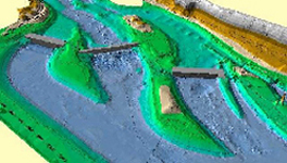
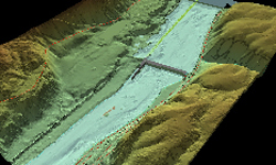
LIDAR
Cartographic Mapping:
-
Composite map compilation
-
Flood plain assessment
-
Master planning
-
3-D digital elevation modeling
-
Riverbooks
A-E Contracting:
-
Project planning and design
-
Specifications writing
-
Contract administration/monitoring
-
Final product review/edit
How to reach us:
Call:
Paul Cedfeldt
(503) 808-4856
Write:
U.S. Army Corps of Engineers
Portland District
ATTN: CENWP-EC-TG
P.O. Box 2946
333 SW First Avenue
Portland OR 97208-2946