Tropical Cyclone Report
Tropical Storm Peter
7 - 11 December 2003
Lixion A. Avila
National Hurricane Center
17 December 2003
Peter became the 16th named tropical
cyclone of the 2003 Atlantic hurricane season. This is the first
time since 1887 that two tropical storms have formed in
December.
a. Synoptic History
A large extratropical gale was located in the far
eastern Atlantic on 5 December. The gale cut off from the
westerlies and moved southward for two days. By 7 December, the
gale began to develop some convection and it is estimated that it
became a subtropical storm at 1800 UTC 7 December. As the cyclone
moved farther south over warmer waters, the convection became
concentrated near the center and it developed well-defined
cyclonically-curved bands of showers suggesting that the cyclone
had acquired tropical characteristics. It is estimated that Peter
became a tropical storm at 0600 UTC 9 December and reached its
maximum winds of 60 knots and a minimum pressure of 990 mb around
1800 UTC 9 December while located about 700 n mi west-northwest of
the Cape Verde Islands. Figure 1 shows Tropical Storm Peter during
its most impressive satellite presentation. By then, Peter was
already moving northward ahead of a strong approaching cold front.
This was the same frontal system that had absorbed
Tropical Storm Odette
a few days earlier. Thereafter, the effects of strong
upper-level winds and cooler sea-surface temperatures caused a
rather rapid weakening of the tropical cyclone. By 0000 UTC on 10
December, the satellite appearance had deteriorated significantly
and by 1200 UTC Peter was a tight swirl of low clouds with
estimated winds of 30 knots. Peter continued to move toward the
north and north-northeastward over cooler waters and became an
extratropical low by 0600 UTC 11 December. A few hours later, the
system was absorbed by a cold front.
The "best track" chart of the tropical cyclone's path
is given in Figure 2,
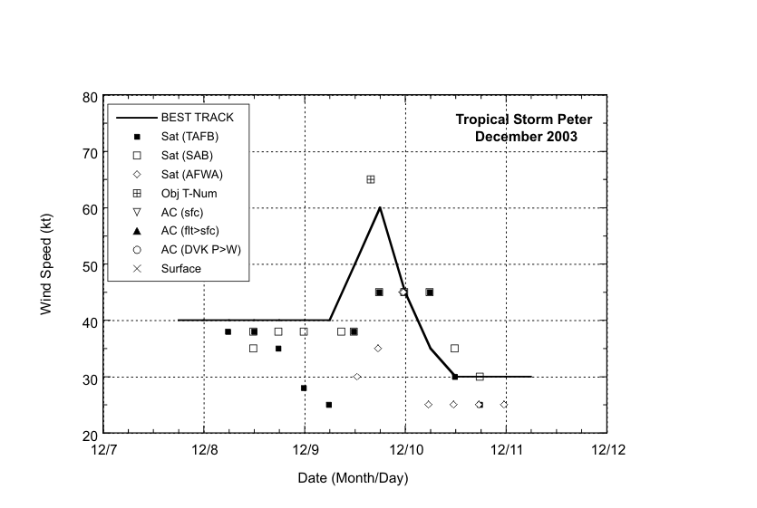
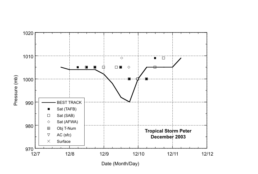
with the wind and pressure histories shown in
Figure 3 and Figure 4, respectively.
The best track positions and
intensities are listed in Table 1.
b. Meteorological Statistics
Observations in Tropical Storm Peter
(Figure 3 and Figure 4)
primarily consist of satellite-based Dvorak technique intensity
estimates from the Tropical Analysis and Forecast Branch (TAFB),
the Satellite Analysis Branch (SAB) and the U.S. Air Force Weather
Agency (AFWA). Visible satellite imagery and microwave data
suggested the development of an eye feature that was best defined
around 1515 UTC 9 December. In general, the presence of an eye
feature on satellite imagery would correspond to a tropical cyclone
of hurricane intensity. In fact, the 3-h average objective Dvorak
T-number was 4.0 during that period. However, the eye feature was
transient and by 1800 UTC it had begun to dissipate. The best
estimate of the maximum winds associated with Peter is 60
knots.
c. Casualty and Damage Statistics
There were no reports of casualties or damage
associated with Peter.
d. Forecast and Warning Critique
Peter was a short-lived tropical cyclone, with too
few forecasts to provide useful verification analysis. Advisories
were initiated when the system became a tropical storm. Previously,
the system was considered a gale center and the forecast
information was included in the Tropical Prediction Center High
Seas Forecast. However, after a post-analysis of satellite imagery,
the system was classified as a subtropical storm for the first 36
hours in the best track. Thereafter, the decision to classify the
cyclone as tropical was heavily based on the satellite
presentation. The cloud pattern was typical of a tropical cyclone
when advisories were initiated. Global models were able to forecast
well in advance, the development of the gale which eventually
became Peter.
Table 1: Best track for
Tropical Storm Peter, 7-11 December 2003.
Date/Time
(UTC) | Position | Pressure
(mb) | Wind Speed
(kt) | Stage |
Lat.
(°N) | Lon.
(°W) |
| 07 / 1800 | 27.5 | 34.5 | 1005 | 40 | subtropical storm |
| 08 / 0000 | 26.1 | 34.8 | 1004 | 40 | " |
| 08 / 0600 | 24.1 | 35.8 | 1004 | 40 | " |
| 08 / 1200 | 22.4 | 36.8 | 1004 | 40 | " |
| 08 / 1800 | 20.7 | 37.9 | 1004 | 40 | " |
| 09 / 0000 | 20.4 | 37.7 | 1002 | 40 | " |
| 09 / 0600 | 20.0 | 37.4 | 998 | 40 | tropical storm |
| 09 / 1200 | 19.5 | 37.2 | 992 | 50 | " |
| 09 / 1800 | 21.0 | 37.0 | 990 | 60 | " |
| 10 / 0000 | 22.2 | 37.0 | 1000 | 45 | " |
| 10 / 0600 | 23.1 | 37.1 | 1005 | 35 | " |
| 10 / 1200 | 23.8 | 37.1 | 1005 | 30 | tropical depression |
| 10 / 1800 | 25.0 | 36.7 | 1005 | 30 | " |
| 11 / 0000 | 26.0 | 36.2 | 1005 | 30 | " |
| 11 / 0600 | 27.5 | 35.0 | 1009 | 30 | extratropical |
| 11 / 1200 | | | | | absorbed by a front |
| 09 / 1800 | 21.0 | 37.0 | 990 | 60 | minimum pressure |

Figure 1:
GOES-12 visible satellite
image of Tropical Storm Peter at 1515 UTC 9 December, 2003. The
image shows the banding-eye feature normally associated with
tropical cyclones of hurricane intensity. However, this feature was
too transient to assume that Peter reached hurricane
status.
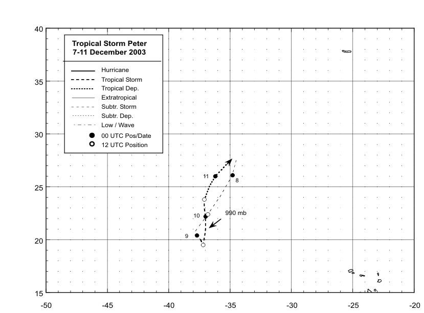
Figure 2:
Best track positions for Tropical Storm
Peter, 7-11 December, 2003.

Figure 3:
Best track maximum sustained surface wind
speed curve for Tropical Storm Peter, 7- 11 December, 2003. See
text for discussion of the peak intensity.

Figure 4:
Best track minimum central pressure curve
for Tropical Storm Peter, 7-11 December, 2003.
|