Tropical Cyclone Report
Tropical Storm Mindy
10 - 14 October 2003
Miles B. Lawrence
National Hurricane Center
14 November 2003
Mindy was a tropical storm with maximum sustained
winds of 40 kt that produced heavy rain over portions of Puerto
Rico and the Dominican Republic.
a. Synoptic History
Mindy originated from a tropical wave that moved from
Africa to the Atlantic Ocean on 1 October. The wave axis neared the
vicinity of the Mona Passage on 9 October where there was a
weakness in the subtropical ridge. On 10 October, in strong
southwesterly vertical shear, the wave acquired a weak low-level
circulation that moved northwestward across the eastern Dominican
Republic. Later that day, the circulation, accompanied by rather
disorganized convection, moved over the Atlantic Ocean and became
Tropical Storm Mindy with 40-kt winds. Mindy turned northward
around the western periphery of the subtropical ridge over the next
two days and gradually weakened in southwesterly to westerly
vertical wind shear of 20 t 25 kt. Mindy weakened to a depression
on 12 October and then turned eastward ahead of an approaching
short-wave trough in the westerlies. Devoid of deep convection, the
remaining swirl of low clouds dissipated early on 14 October while
located about 400 n mi south-southwest of Bermuda.
The center of Mindy passed near the Turks and Caicos
Islands on 11 October, but heavy rain and tropical storm force
winds remained east of these islands.
The "best track" chart of the tropical cyclone's path
is given in Figure 1, with the wind and pressure histories shown in
Figure 2 and Figure 3,
respectively. The best track positions and
intensities are listed in Table 1.
b. Meteorological Statistics
Observations in Mindy (Figure 2 and Figure 3)
include
satellite-based Dvorak technique intensity estimates from the
Tropical Analysis and Forecast Branch (TAFB), the Satellite
Analysis Branch (SAB) and the U. S. Air Force Weather Agency
(AFWA), as well as flight-level observations from flights of the
53rd Weather Reconnaissance Squadron of the U. S. Air
Force Reserve Command. A reconnaissance aircraft flew into the
system as it moved away from the Dominican Republic. At first,
aircraft wind observations at 1500 ft flight level did not show a
closed circulation. By 2146 UTC, a closed circulation was observed,
along with a minimum surface pressure of 1002 mb . The aircraft
data is the basis for identifying Mindy as a tropical cyclone at
1800 UTC. An aircraft-measured wind speed of 54 kt at a flight
level of 1500 ft, along with subjective Dvorak satellite estimates
of 35-45 kt, are the reasons for assigning a wind speed of 40 kt to
Mindy at its inception as a tropical cyclone.
There were no ship reports with tropical storm force
wind speeds in connection with Mindy. Grand Turk reported 27 kt and
1007.1 mb on 11 October as Mindy passed just east of this
location.
c. Casualty and Damage Statistics
Mindy produced periods of heavy rain over portions of
Puerto Rico and the eastern Dominican Republic, but there were no
reports of damages or casualties.
d. Forecast and Warning Critique
Average official track errors (with the number of
cases in parentheses) for Mindy were 40 (12), 95 (10), 184 (8), 292
(6),and 414 (2) n mi for the 12, 24, 36, 48, and 72 h forecasts,
respectively1.
These errors are considerably larger than the average
official track errors for the 10-yr period 1993-2002 (45, 81, 116,
150, and 225 n mi). These large errors were the result of not
correctly forecasting the sharp turn toward the east on 12 October.
The guidance models also had large errors for the same reason.
Mindy did not last long enough to verify any 96 and 120 h
forecasts.
Average official intensity errors were 3, 9, 14, 18,
and 23 kt for the 12, 24, 36, 48, and 72 h forecasts, respectively.
For comparison, the average official intensity errors over the
10-yr period 1993-2002 are 6, 10, 13, 15, and 19 kt,
respectively.
A tropical storm warning was issued for the
Southeastern Bahamas and the Turks and Caicos Islands (Table 2).
However, tropical storm conditions passed just east of the warned
area.
1All forecast verifications in this report include the depression stage of
the cyclone. National Hurricane Center verifications presented in these
reports prior to 2003 did not include the depression stage.
Table 1: Best track for Tropical Storm Mindy, 10-14 October
2003.
Date/Time
(UTC) | Position | Pressure
(mb) | Wind Speed
(kt) | Stage |
Lat.
(°N) | Lon.
(°W) |
| 10/1800 | 19.1 | 68.8 | 1004 | 40 | tropical storm |
| 11/0000 | 20.1 | 69.7 | 1002 | 40 | " |
| 11/0600 | 20.9 | 70.4 | 1003 | 40 | " |
| 11/1200 | 21.8 | 71.3 | 1007 | 35 | " |
| 11/1800 | 22.7 | 71.5 | 1007 | 35 | " |
| 12/0000 | 23.6 | 71.9 | 1006 | 35 | " |
| 12/0600 | 24.0 | 72.4 | 1007 | 30 | tropical depression |
| 12/1200 | 24.7 | 72.2 | 1008 | 30 | " |
| 12/1800 | 25.5 | 72.0 | 1008 | 30 | " |
| 13/0000 | 25.6 | 71.0 | 1008 | 30 | " |
| 13/0600 | 25.7 | 70.3 | 1008 | 30 | " |
| 13/1200 | 25.8 | 69.3 | 1008 | 30 | " |
| 13/1800 | 25.9 | 68.3 | 1007 | 30 | " |
| 14/0000 | 25.9 | 67.7 | 1008 | 25 | " |
| 14/0600 | | | | | dissipated |
| 11/0000 | 20.1 | 69.7 | 1002 | 40 | minimum pressure |
Table 2: Watch and warning summary for Tropical Storm
Mindy, 10-14 October 2003.
| Date/Time | Action | Location |
| 10/2100 | tropical storm warning
issued | southeastern Bahamas and Turks
and Turks and Caicos islandsT |
| 11/1500 | tropical storm warning
discontinued | southeastern Bahamas and Turks
and Turks and Caicos islands |
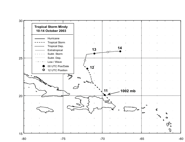
Figure 1: Best track
positions for Tropical Storm Mindy, 10-14 October 2003.
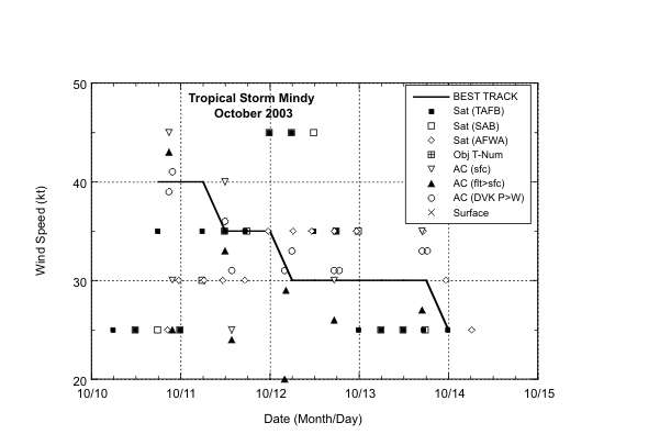
Figure 2:
Selected wind
observations and best track maximum sustained
surface wind speed curve for Tropical Storm Mindy, 10-14 October
2003. Aircraft observations have been adjusted for elevation using
90%, 80%, and 80% reduction factors for observations from 850 mb,
and 1500 ft, respectively.
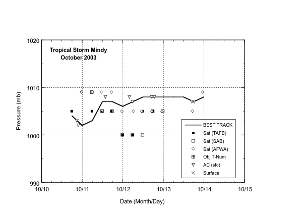
Figure 3:
Selected pressure
observations and best track minimum central
pressure curve for Tropical Storm Mindy, 10-14 October
2003.
|


