Tropical Cyclone Report
Tropical Storm Nicholas
13 - 23 October 2003
Jack Beven
National Hurricane Center
7 January 2004
Nicholas was a long-lived tropical storm that
remained over the Atlantic far from land.
a. Synoptic History
Nicholas developed from a tropical wave that moved
westward from the coast of Africa on 9 October. A broad low
pressure area formed along the wave on 10 October, and convection
slowly became better organized during the following two days. It is
estimated that a tropical depression formed near 0000 UTC 13
October about 790 n mi west-southwest of the southern Cape Verde
Islands. The "best track" chart of the tropical cyclone's path is
given in Figure 1, with the wind and pressure histories shown in
Figure 2 and Figure 3,
respectively. The best track positions and
intensities are listed in Table 1.
The cyclone formed in an area of southerly to
southwesterly vertical wind shear, and it would remain in such an
environment through its lifetime. The system moved slowly
west-northwestward and gradually strengthened, becoming Tropical
Storm Nicholas late on 14 October. It then moved northwestward for
the next three days, reaching a peak intensity of 60 kt on 17
October. A slow and erratic northward motion occurred from 18-20
October while Nicholas gradually weakened due to the shear. The
storm turned west-northwestward later on 20 October and westward on
21 October. This was accompanied by slight re-intensification.
Nicholas again turned northwestward on 22 October and weakening
resumed. The cyclone became a depression on 23 October as it turned
northward, and it became a non-convective remnant low on 24
October. The low merged with a cold front later that day, becoming
extratropical about 505 n mi east-southeast of Bermuda.
The post-tropical cyclone history of Nicholas is
complex. After becoming extratropical, the remnant low made a large
anticyclonic loop from 24-28 October. A subsequent
west-northwestward to westward motion on 28-29 October occurred
while Nicholas moved along the warm front associated with a
non-tropical low to its southwest. A second anticyclonic loop took
place on 29-31 October, which was followed by a small cyclonic loop
early on 1 November while the Nicholas low separated from the
frontal system. The Nicholas remnant was finally absorbed into a
non-tropical low pressure area late that day about 300 n mi
south-southwest of Bermuda. This low, which developed sporadic
bursts of central convection, moved westward to the Florida
Peninsula on 3 November and then northwestward to the northern
coast of the Gulf of Mexico on 5 November.
b. Meteorological Statistics
Observations in Nicholas
(Figure 2 and Figure 3) include
satellite-based Dvorak technique intensity estimates from the
Tropical Analysis and Forecast Branch (TAFB), the Satellite
Analysis Branch (SAB) and the U. S. Air Force Weather Agency
(AFWA). Microwave satellite imagery from the NOAA polar-orbiting
satellites, the NASA Tropical Rainfall Measuring Mission (TRMM),
the NASA QuikSCAT, and the Defense Meteorological Satellite Program
(DMSP) satellites were also useful in tracking Nicholas.
Dvorak satellite intensity estimates from all
agencies suggested that Nicholas could have been a hurricane near
1200 UTC 17 October. However, several microwave images made near
that time showed that the cyclone was still partly sheared, with no
evidence of an eye, an eyewall, or well-defined convective bands.
Thus, it is estimated that Nicholas did not reach hurricane
strength and that the maximum winds were 60 kt.
The remnants of Nicolas became involved in a complex
weather pattern between 27 October and 1 November, and the exact
time of dissipation occurred is uncertain. Operationally, the
non-tropical low that crossed Florida was occasionally referred to
as the remnants of Nicholas in tropical weather outlooks issued by
the National Hurricane Center. Post-analysis suggests instead that
this system absorbed the remnants of Nicholas.
There are no known surface observations of
tropical-storm force or stronger winds associated with
Nicholas.
c. Casualty and Damage Statistics
There were no reports of damages or casualties
associated with Nicholas.
d. Forecast and Warning Critique
Average official track errors (with the number of
cases in parentheses) for Nicholas were 39 (39), 64 (37), 95 (35),
127 (33), 171 (29), 185 (25), and 158 (21) n mi for the 12, 24, 36,
48, 72, 96, and 120 h forecasts, respectively1.
These errors are lower than the average official track
errors for the 10-yr period 1993-20022
(45, 81, 116, 150, 225, 282, and 374 n mi, respectively),
(Table 2). The track forecast errors are also lower than the errors
of the Climatology-Persistence model (44, 83, 125, 171, 305, 455,
and 614 n mi for the 12, 24, 36, 48, 72, 96, and 120 h forecasts,
respectively) including almost 75% lower at 120 h. By this measure,
the track forecasts had significant skill.
Although the track forecast errors are quite small,
the slow and erratic northward motion on 18-20 October was not well
forecast. The track forecasts called for a continuing northwestward
motion, which led to 24 hr track forecast errors of near 125 n mi
and 48 h errors of near 200 n mi during that time.
The official track forecasts were for the most part
better than the model guidance. The average errors of the GFDL
model were generally the lowest of the dynamical models through 48
h and were less than those of the official forecast from 24-72 h.
The GFS model (AVNO) and the medium BAM (BAMM) generally were the
best of the models after 72 h and showed lower mean forecast errors
than the official forecasts at 48-96 h. The consensus model GUNA
had lower average errors than the official forecasts for the 36-72
hr period.
Average official intensity errors were 4, 5, 5, 7, 9,
11, and 15 kt for the 12, 24, 36, 48, 72, 96, and 120 h forecasts,
respectively. For comparison, the average official intensity errors
over the 10-yr period 1993-2002 are 6, 10, 13, 15, 19, 21, and 22
kt, respectively. The average intensity errors for
Climatology-Persistence were 5, 7, 7, 9, 11, 15, and 20 kt,
respectively. For the most part, the intensity forecasts correctly
anticipated that vertical shear would restrict the development of
Nicholas and eventually cause dissipation.
No watches or warnings were issued for Nicholas.
1All forecast verifications in this report include the
depression stage of the cyclone. National Hurricane Center verifications
presented in these reports prior to 2003 did not include the depression
stage.
2Errors given for the 96 and 120 h periods are averages
over the two-year period 2001-2002.
Table 1: Best track
for Tropical Storm Nicholas, 13-23 October 2003.
Date/Time
(UTC) | Position | Pressure
(mb) | Wind Speed
(kt) | Stage |
Lat.
(°N) | Lon.
(°W) |
| 13 / 0000 | 9.5 | 37.0 | 1009 | 25 | tropical
depression |
| 13 / 0600 | 9.5 | 37.7 | 1008 | 25 | " |
| 13 / 1200 | 9.6 | 38.4 | 1008 | 25 | " |
| 13 / 1800 | 9.9 | 38.9 | 1007 | 30 | " |
| 14 / 0000 | 10.2 | 39.5 | 1006 | 30 | " |
| 14 / 0600 | 10.5 | 40.3 | 1006 | 30 | " |
| 14 / 1200 | 10.7 | 41.1 | 1006 | 30 | " |
| 14 / 1800 | 10.9 | 41.9 | 1005 | 35 | tropical
storm |
| 15 / 0000 | 11.2 | 42.5 | 1003 | 40 | " |
| 15 / 0600 | 11.5 | 43.1 | 1000 | 45 | " |
| 15 / 1200 | 11.8 | 43.7 | 1000 | 45 | " |
| 15 / 1800 | 12.2 | 44.3 | 1000 | 45 | " |
| 16 / 0000 | 12.6 | 45.0 | 1000 | 45 | " |
| 16 / 0600 | 13.1 | 45.6 | 1000 | 45 | " |
| 16 / 1200 | 13.5 | 46.0 | 997 | 50 | " |
| 16 / 1800 | 14.0 | 46.6 | 994 | 55 | " |
| 17 / 0000 | 14.4 | 47.2 | 995 | 55 | " |
| 17 / 0600 | 15.0 | 47.6 | 994 | 55 | " |
| 17 / 1200 | 15.5 | 48.0 | 990 | 60 | " |
| 17 / 1800 | 16.1 | 48.1 | 994 | 55 | " |
| 18 / 0000 | 16.3 | 48.1 | 994 | 55 | " |
| 18 / 0600 | 16.3 | 47.9 | 994 | 55 | " |
| 18 / 1200 | 16.5 | 47.8 | 994 | 55 | " |
| 18 / 1800 | 16.7 | 47.7 | 997 | 50 | " |
| 19 / 0000 | 17.0 | 47.6 | 997 | 50 | " |
| 19 / 0600 | 17.3 | 47.4 | 997 | 50 | " |
| 19 / 1200 | 17.6 | 47.3 | 997 | 50 | " |
| 19 / 1800 | 17.6 | 47.5 | 1000 | 45 | " |
| 20 / 0000 | 17.4 | 47.7 | 1000 | 45 | " |
| 20 / 0600 | 17.6 | 47.9 | 1000 | 45 | " |
| 20 / 1200 | 17.8 | 48.1 | 1002 | 40 | " |
| 20 / 1800 | 18.1 | 48.9 | 1005 | 35 | " |
| 21 / 0000 | 18.4 | 49.7 | 1005 | 35 | " |
| 21 / 0600 | 18.6 | 50.3 | 1002 | 40 | " |
| 21 / 1200 | 18.7 | 51.0 | 1000 | 45 | " |
| 21 / 1800 | 18.6 | 52.0 | 1000 | 45 | " |
| 22 / 0000 | 18.5 | 52.9 | 1002 | 40 | " |
| 22 / 0600 | 18.5 | 53.6 | 1005 | 35 | " |
| 22 / 1200 | 18.8 | 54.1 | 1005 | 35 | " |
| 22 / 1800 | 19.5 | 54.6 | 1005 | 35 | " |
| 23 / 0000 | 20.4 | 55.4 | 1005 | 35 | " |
| 23 / 0600 | 21.5 | 56.0 | 1006 | 30 | tropical
depression |
| 23 / 1200 | 22.5 | 56.4 | 1007 | 30 | " |
| 23 / 1800 | 23.6 | 56.9 | 1008 | 30 | " |
| 24 / 0000 | 25.1 | 56.7 | 1009 | 25 | low |
| 24 / 0600 | 27.1 | 56.4 | 1010 | 25 | " |
| 24 / 1200 | 28.8 | 56.1 | 1011 | 25 | " |
| 24 / 1800 | 30.2 | 55.7 | 1012 | 25 | extratropical |
| 25 / 0000 | 31.4 | 54.8 | 1013 | 20 | " |
| 25 / 0600 | 32.2 | 53.5 | 1014 | 20 | " |
| 25 / 1200 | 32.4 | 52.0 | 1014 | 20 | " |
| 25 / 1800 | 32.5 | 50.5 | 1013 | 20 | " |
| 26 / 0000 | 31.9 | 49.5 | 1013 | 20 | " |
| 26 / 0600 | 30.7 | 49.1 | 1012 | 25 | " |
| 26 / 1200 | 29.3 | 49.0 | 1010 | 30 | " |
| 26 / 1800 | 28.3 | 49.6 | 1008 | 30 | " |
| 27 / 0000 | 27.4 | 50.5 | 1007 | 30 | " |
| 27 / 0600 | 26.7 | 52.0 | 1007 | 35 | " |
| 27 / 1200 | 26.4 | 53.7 | 1007 | 35 | " |
| 27 / 1800 | 26.6 | 55.5 | 1007 | 35 | " |
| 28 / 0000 | 27.1 | 57.3 | 1008 | 30 | " |
| 28 / 0600 | 27.9 | 59.1 | 1009 | 30 | " |
| 28 / 1200 | 28.9 | 60.8 | 1009 | 30 | " |
| 28 / 1800 | 29.5 | 62.8 | 1009 | 30 | " |
| 29 / 0000 | 29.4 | 65.1 | 1009 | 25 | " |
| 29 / 0600 | 29.3 | 67.1 | 1009 | 25 | " |
| 29 / 1200 | 29.5 | 68.0 | 1009 | 25 | " |
| 29 / 1800 | 30.1 | 68.0 | 1009 | 25 | " |
| 30 / 0000 | 30.4 | 67.2 | 1009 | 25 | " |
| 30 / 0600 | 30.4 | 66.4 | 1009 | 25 | " |
| 30 / 1200 | 30.0 | 65.8 | 1008 | 30 | " |
| 30 / 1800 | 29.3 | 65.3 | 1008 | 30 | " |
| 31 / 0000 | 28.7 | 65.5 | 1008 | 30 | " |
| 31 / 0600 | 28.3 | 66.0 | 1008 | 30 | low |
| 31 / 1200 | 27.7 | 66.3 | 1007 | 30 | " |
| 31 / 1800 | 27.0 | 66.4 | 1006 | 30 | " |
| 01 / 0000 | 26.4 | 66.3 | 1005 | 30 | " |
| 01 / 0600 | 26.5 | 66.0 | 1005 | 30 | " |
| 01 / 1200 | 27.0 | 66.3 | 1005 | 30 | " |
| 01 / 1800 | 27.7 | 67.0 | 1005 | 30 | " |
| 02 / 0000 | | | | | absorbed by low pressure system |
| 17 / 1200 | 15.5 | 48.0 | 990 | 60 | minimum pressure |
Table 2: Preliminary forecast evaluation (heterogeneous
sample) for Tropical Storm Nicholas, 13-23 October
2003. Forecast errors (n
mi) are followed by
the number of forecasts in parentheses. Errors smaller than the NHC
official forecast are shown in bold-face
type. Verification
includes the depression stage, but does not include the
extratropical stage.
| Forecast Technique | Period (hours) |
| 12 | 24 | 36 | 48 | 72 | 96 | 120 |
| CLP5 | 44 (42) | 83 (40) | 125 (38) | 171 (36) | 305 (32) | 455 (28) | 614 (24) |
| A90E | 44 (42) | 82 (40) | 122 (38) | 167 (36) | 270 (32) | 394 (28) | 496 (24) |
| A98E | 44 (42) | 83 (40) | 120 (38) | 163 (36) | 265 (32) | 387 (28) | 487 (24) |
| A9UK | 42 (20) | 81 (19) | 119 (18) | 166 (17) | 282 (15) | | |
| LBAR | 43 (42) | 75 (40) | 99 (38) | 124
(36) | 238 (32) | 418 (28) | 572 (24) |
| BAMD | 55 (42) | 89 (40) | 112 (38) | 129 (36) | 178 (32) | 239 (28) | 333 (24) |
| BAMM | 45 (42) | 72 (40) | 97 (38) | 117
(36) | 167
(32) | 175
(28) | 187 (24) |
| BAMS | 53 (42) | 88 (40) | 115 (38) | 137 (36) | 190 (32) | 223 (28) | 251 (24) |
| AF1I | 72 (31) | 149 (29) | 236 (27) | 309 (26) | 425 (23) | | |
| AFW1* | 92 (16) | 152 (15) | 239 (14) | 333 (13) | 435 (12) | | |
| GFNI | 44 (30) | 84 (28) | 129 (28) | 178 (26) | 273 (26) | | |
| GFDN* | 46 (15) | 71 (15) | 104 (14) | 152 (14) | 243 (13) | | |
| GFDI | 36
(36) | 58
(35) | 77
(33) | 99
(29) | 162
(26) | 259 (23) | 402 (19) |
| GFDL* | 42 (38) | 58
(37) | 74
(30) | 89
(28) | 145
(25) | 229 (23) | 373 (19) |
| UKMI | 44 (37) | 78 (35) | 106 (33) | 136 (31) | 194 (27) | 231 (23) | 234 (19) |
| UKM* | 58 (19) | 86 (18) | 113 (17) | 135 (16) | 188 (14) | 222 (12) | 247 (10) |
| NGPI | 48 (39) | 96 (37) | 146 (35) | 207 (33) | 315 (30) | 415 (26) | 479 (22) |
| NGPS* | 49 (38) | 92 (36) | 141 (34) | 194 (32) | 304 (30) | 398 (26) | 465 (22) |
| AVNI | 45 (37) | 75 (35) | 99 (33) | 120
(31) | 133
(27) | 137
(23) | 173 (19) |
| AVNO* | 53 (37) | 82 (36) | 105 (34) | 122
(32) | 139
(28) | 148
(24) | 177 (19) |
| AEMI | 52 (19) | 95 (18) | 136 (17) | 164 (16) | 226 (13) | 351 ( 9) | 458 ( 7) |
| AEMN* | 59 (17) | 87 (16) | 116 (15) | 143 (14) | 188 (12) | 235 (9) | 426 (6) |
| GUNS | 37
(34) | 68 (33) | 97 (31) | 128 (29) | 181 (26) | 247 (23) | 307 (19) |
| GUNA | 37
(34) | 65 (33) | 91
(31) | 117
(29) | 155
(26) | 197 (23) | 235 (19) |
| FSSE | 40 (18) | 72 (17) | 97 (16) | 127 (15) | 170
(13) | | |
| OFCI | 40 (38) | 70 (36) | 103 (34) | 133 (32) | 176 (28) | 177
(24) | 157
(20) |
| OFCL | 39 (39) | 64 (37) | 95 (35) | 127 (33) | 171 (29) | 185 (25) | 158 (21) |
| NHC Official (1993-2002 mean) | 45 (2985) | 81 (2726) | 116 (2481) | 150 (2230) | 225 (1819) | 282 (265) | 374 (216) |
*Output
from these models was unavailable at time forecast
issued. |
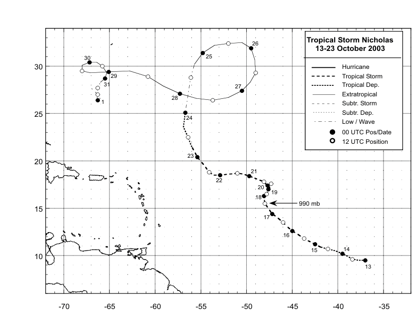
Figure 1:
Best track positions for
Tropical Storm Nicholas, 13-23 October 2003.
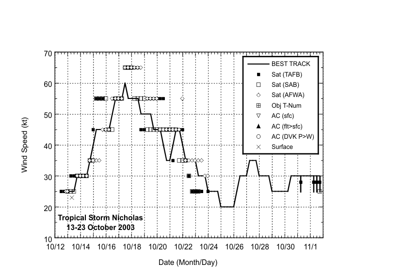
Figure 2:
Selected wind
estimates/observations and best track maximum
sustained surface wind speed curve for Tropical Storm Nicholas,
13-23 October 2003.Solid black bars denote
wind ranges for the Hebert-Poteat subtropical cyclone
technique.
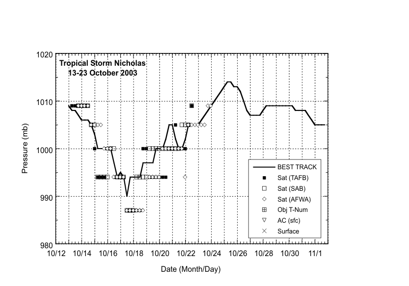
Figure 3:
Selected pressure
estimates and best track minimum central pressure
curve for Tropical Storm Nicholas, 13-23 October 2003.
|


