Tropical Cyclone Report
Tropical Storm Odette
4 - 7 December 2003
James L. Franklin
National Hurricane Center
19 December 2003
Odette was a rare December tropical storm that made
landfall in the Dominican Republic and was responsible for eight
deaths. It was the first December tropical storm on record to form
in the Caribbean Sea.
a. Synoptic History
As the 2003 Atlantic hurricane season came to a
nominal close on 30 November, a stationary front extended across
eastern Cuba southwestward into the southwestern Caribbean Sea. An
area of low pressure developed in the frontal zone on 1 December
just north of Panama, where it remained nearly stationary for a
couple of days while the front gradually retreated northward and
separated from the surface low. During this time, convection
increased and became organized, and by 3 December, a distinct
mid-level circulation had developed about 120 n mi north of the
surface center. A weak tropical wave moved into the area and this
event coincided with an increase in the overall organization of the
system early on 4 December. A tropical depression formed at 1200
UTC that day about 300 n mi south of Kingston, Jamaica.
The "best track" chart of the tropical cyclone's path
is given in Figure 1, with the wind and pressure histories shown in
Figure 2 and Figure 3,
respectively. The best track positions and
intensities are listed in Table 1. The depression strengthened and
became a tropical storm at 1800 UTC 4 December about 285 n mi
south-southeast of Kingston. Moving east-northeastward, Odette
continued to strengthen despite moderate southwesterly shear, and
late in the day microwave imagery indicated a formative eyewall. By
1200 UTC the next day, when the first reconnaissance aircraft
reached the system, the convective structure was deteriorating and
the central pressure was rising. Odette turned north-northeastward
with increased forward speed, and strengthened slightly on 6
December, reaching its peak intensity of 55 kt at 0600 UTC. During
the day the forward speed of the system slowed again although the
convection continued to advance northeastward at a more rapid rate;
this lack of organization vertically was typical of Odette
throughout it lifetime. Odette weakened slightly by the time it
made landfall near Cabo Falso on the Barahona peninsula of the
Dominican Republic around 2300 UTC 6 December.
The circulation center became disrupted during its
overnight passage across the Dominican Republic, but tropical storm
force winds were maintained in the convection east of the center.
Odette accelerated northeastward in advance of an approaching cold
front, and became extratropical when the low became embedded in the
frontal zone near 1800 UTC 7 December. Odette's extratropical
remnant raced northeastward with a distinct circulation for another
two days within the frontal zone before dissipating after 1800 UTC
9 December.
b. Meteorological Statistics
Observations in Odette (Figure 2 and Figure 3)
include
satellite-based Dvorak technique intensity estimates from the
Tropical Analysis and Forecast Branch (TAFB), the Satellite
Analysis Branch (SAB) and the U. S. Air Force Weather Agency
(AFWA), as well as flight-level and dropwindsonde observations from
flights of the 53rd Weather Reconnaissance Squadron of
the U. S. Air Force Reserve Command. On several occasions
dropwindsondes released at the flight-level center of circulation
encountered relatively strong winds at the surface; consequently,
the best track pressure curve does not precisely follow the
aircraft data plotted in Figure 3.
As noted above, microwave imagery indicated a
formative eyewall late on 4 December, but that this feature had
weakened by the time the first reconnaissance aircraft reached the
cyclone. Scatterometer data are also suggestive that Odette may
have been stronger than indicated in the best track on 4 December,
but the data were not consistent from pass to pass and have been
largely discounted.
Ship reports of winds of tropical storm force
associated with Odette are given in Table 2, and selected surface
observations are given in Table 3. There was one report of over 9
inches of rain in the Dominican Republic.
c. Casualty and Damage Statistics
The government of the Dominican Republic attributes 8
deaths and 14 injuries directly to Odette, with most of these from
mud slides or flash floods. There were also 2 indirect deaths (due
to heart attacks) associated with the cyclone. Press reports
indicate that Odette downed trees and power lines, and damaged
buildings, bridges, and large areas of agricultural land.
Approximately 35% of the banana crop was destroyed. Media reports
indicate little apparent impact from the storm in Haiti.
d. Forecast and Warning Critique
Average official track errors (with the number of
cases in parentheses) for Odette were 62 (11), 128 (9), 233 (7),
506 (5), and 1162 (1) n mi for the 12, 24, 36, 48, and 72 h
forecasts, respectively1.
These errors are significantly greater than the average
official track errors for the 10-yr period 1993-2002 (45, 81, 116,
150, and 225 n mi, respectively). Official track forecasts were
also less accurate than virtually all of the objective forecast
guidance (Table 4). The initial forecast for Odette followed the
GFDL model, which greatly over-forecast both the strength and the
northeastward acceleration of the system. Subsequent official
forecasts pulled back on the acceleration, but in general the
forward speed of the cyclone from model guidance was too fast. It
appears as though Odette did not fully respond to the strong
southwesterly flow aloft, and this may have been related to the
poor vertical continuity of Odette's circulation.
Average official intensity errors were 5, 9, 12, 10,
and 0 kt for the 12, 24, 36, 48, and 72 h forecasts, respectively.
For comparison, the average official intensity errors over the
10-yr period 1993-2002 are 6, 10, 13, 15, and 19 kt,
respectively.
Table 5 lists the watches and warnings associated
with Odette.
1All forecast verifications in this report include the
depression stage of the cyclone. National Hurricane Center verifications
presented in these reports prior to 2003 did not include the depression
stage.
Table 1: Best track for Tropical Storm Odette, 4-7 December
2003.
Date/Time
(UTC) | Position | Pressure
(mb) | Wind Speed
(kt) | Stage |
Lat.
(°N) | Lon.
(°W) |
| 04 / 1200 | 12.9 | 76.2 | 1005 | 30 | tropical
depression |
| 04 / 1800 | 13.3 | 75.7 | 1003 | 35 | tropical
storm |
| 05 / 0000 | 13.7 | 75.2 | 1000 | 45 | " |
| 05 / 0600 | 13.9 | 74.8 | 993 | 50 | " |
| 05 / 1200 | 14.1 | 74.4 | 993 | 50 | " |
| 05 / 1800 | 14.3 | 73.8 | 995 | 50 | " |
| 06 / 0000 | 15.0 | 73.0 | 995 | 50 | " |
| 06 / 0600 | 15.9 | 72.5 | 995 | 55 | " |
| 06 / 1200 | 16.6 | 72.2 | 995 | 55 | " |
| 06 / 1800 | 17.2 | 72.0 | 994 | 55 | " |
| 07 / 0000 | 17.9 | 71.4 | 997 | 45 | " |
| 07 / 0600 | 18.9 | 70.6 | 1000 | 40 | " |
| 07 / 1200 | 20.5 | 69.5 | 1003 | 40 | " |
| 07 / 1800 | 22.4 | 68.1 | 1002 | 45 | extratropical |
| 08 / 0000 | 23.5 | 65.9 | 1002 | 45 | " |
| 08 / 0600 | 24.4 | 63.7 | 1004 | 45 | " |
| 08 / 1200 | 25.4 | 61.6 | 1005 | 40 | " |
| 08 / 1800 | 26.3 | 59.5 | 1005 | 40 | " |
| 09 / 0000 | 27.4 | 57.1 | 1005 | 40 | " |
| 09 / 0600 | 28.9 | 54.2 | 1006 | 40 | " |
| 09 / 1200 | 30.4 | 51.1 | 1006 | 40 | " |
| 09 / 1800 | 31.9 | 47.7 | 1006 | 40 | " |
| 10 / 0000 | | | | | absorbed in frontal zone |
| 06 / 2300 | 17.8 | 71.5 | 995 | 50 | landfall near Cabo Falso, Dominican Republic |
| 06 / 0600 | 15.9 | 72.5 | 995 | 55 | maximum wind |
| 05 / 0600 | 13.9 | 74.8 | 993 | 50 | minimum pressure |
Table 2:
Selected ship reports with winds of at least 34 kt
for Tropical Storm Odette, 4-7 December 2003.
| Ship Name or Call Sign | Date/Time (UTC) | Lat.
(°N) | Lon.
(°W) | Wind dir/speed (deg/kt) | Pressure (mb) |
| C6FU9 | 05 / 1200 | 11.8 | 73.9 | 210/37 | 1008.0 |
| MZRS8 | 06 / 0600 | 14.5 | 68.5 | 130/36 | 1006.5 |
| MZRS8 | 06 / 1200 | 15.7 | 67.3 | 130/38 | 1009.0 |
| UCAB | 08 / 1200 | 23.6 | 61.3 | 260/35 | 1009.3 |
|
Table 3: Selected surface observations for Tropical Storm
Odette, 4-7 December 2003.
| | Minimum
Sea-level
Pressure | Maximum Surface Wind Speed
(kt) | |
| Location | Date/
Time
(UTC) | Press.
(mb) | Date/
Time
(UTC) | Sust.
Wind
(kts) | Peak
Gust (kts) | Storm
Surge
(ft) | Storm
Tide
(ft) | Rain
(storm total)
(in) |
| Dominican Republic |
| Santo Domingo | | | 6/23009 | | 50 | | | |
| Isla Saona | | | | | | | | 9.07 |
| Higuey | | | | | | | | 8.54 |
| Valle Nuevo | | | | | | | | 5.55 |
| Moca | | | | | | | | 5.17 |
| Hata Mayor | | | | | | | | 4.65 |
Table 4: Preliminary forecast evaluation (heterogeneous
sample) for Tropical Storm Odette, 4-7 December 2003. Forecast errors (n
mi) are followed by
the number of forecasts in parentheses. Errors smaller than the NHC
official forecast are shown in bold-face
type. Verification
includes the depression stage, but does not include the
extratropical stage.
| Forecast Technique | Period (hours) |
| 12 | 24 | 36 | 48 | 72 | 96 | 120 |
| CLP5 | 57 (11) | 77 (9) | 112 (7) | 128 (5) | 311 (1) | | |
| GFNI | 57 (7) | 58 (5) | 50 (3) | 76 (1) | | | |
| GFDI | 44 (10) | 114 (8) | 188 (6) | 314 (4) | 1150 (1) | | |
| LBAR | 54 (11) | 124 (9) | 200 (7) | 330 (5) | 641 (1) | | |
| AVNI | 70 (9) | 142 (7) | 185 (5) | 202 (3) | | | |
| AEMI | 59 (7) | 106 (5) | 194 (4) | 182 (2) | | | |
| BAMD | 64 (11) | 137 (9) | 215 (7) | 359 (5) | 946 (1) | | |
| BAMM | 52 (11) | 100 (9) | 146 (7) | 185 (5) | 507 (1) | | |
| BAMS | 83 (11) | 129 (9) | 160 (7) | 158 (5) | 70 (1) | | |
| NGPI | 66 (9) | 113 (7) | 115 (5) | 181 (3) | 376 (1) | | |
| UKMI | 47 (10) | 80 (8) | 104 (6) | 121 (4) | | | |
| A98E | 57 (11) | 77 (9) | 122 (7) | 154 (5) | 242 (1) | | |
| A9UK | 49 (6) | 81 (5) | 130 (4) | 181 (3) | 318 (1) | | |
| GUNS | 45 (8) | 81 (6) | 98 (4) | 156 (2) | | | |
| GUNA | 48 (8) | 93 (6) | 117 (4) | 151 (2) | | | |
| OFCL | 62 (11) | 128 (9) | 233 (7) | 506 (5) | 1162 (1) | | |
| NHC Official (1993-2002 mean) | 45 (2985) | 81 (2726) | 116 (2481) | 150 (2230) | 225 (1819) | | |
|
Table 5: Watch and warning summary for Tropical Storm
Odette, 4-7 December 2003.
| Date/Time | Action | Location |
| 4 / 1500 | Tropical Storm Watch issued | Santo Domingo to Haiti/DR Border |
| 4 / 1500 | Tropical Storm Watch issued | Turks and Caicos Is to Southeastern
Bahamas |
| 4 / 1500 | Tropical Storm Warning issued | Haiti |
| 4 / 1800 | Tropical Storm Watch issued | Jamaica |
| 4 / 2100 | Tropical Storm Watch changed to Tropical Storm
Warning | Jamaica |
| 5 / 0300 | Tropical Storm Watch changed to Tropical Storm
Warning | Santo Domingo to Haiti/DR Border |
| 5 / 1500 | Tropical Storm Warning modified | Isla Saona to Haiti/DR Border |
| 5 / 2100 | Tropical Storm Warning discontinued | Jamaica |
| 7 / 0900 | Tropical Storm Watch discontinued | All |
| 7 / 0900 | Tropical Storm Warning discontinued | Haiti |
| 7 / 1200 | Tropical Storm Warning discontinued | All |
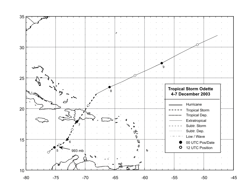
Figure 1:
Best track positions for Tropical Storm Odette, 4-7 December
2003.

Figure 2:
Selected wind observations and best track maximum sustained
surface wind speed curve for Tropical Storm Odette, 4-7 December 2003.
Aircraft observations have been adjusted for elevation using 90%, 80%, and
80% reduction factors for observations from 700 mb, 850 mb, and 1500 ft,
respectively. Dropwindsonde observations include actual 10 m winds (sfc), as
well as surface estimates derived from the mean wind over the lowest 150 m
of the wind sounding (LLM), and from the sounding boundary layer mean (MBL).
Landfall in the Dominican Republic is indicated by the thin vertical
line.
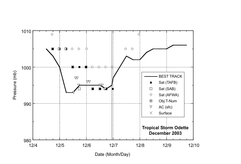
Figure 3:
Selected pressure observations and best track minimum
central pressure curve for Tropical Storm Odette, 4-7 December 2003.Landfall
in the Dominican Republic is indicated by the thin vertical line.On several
occasions dropwindsondes released at the flight-level center of circulation
encountered relatively strong winds at the surface; consequently, the best
track pressure curve does not precisely follow the plotted aircraft
data.
|


