Tropical Cyclone Report
Hurricane Kate
25 September - 7 October 2003
Kate had a long, rather unusual track over the
east-central Atlantic. It became a powerful hurricane at
subtropical latitudes.
a. Synoptic History
A tropical wave crossed the coast of western Africa
on 21 September and moved slowly westward, passing near the Cape
Verde Islands on 23 September. Although the system was not well
organized, meteorologists at the Tropical Analysis and Forecast
Branch (TAFB) and the Satellite Analysis Branch (SAB) identified a
low-level circulation center several hundred miles west-southwest
of the Cape Verde Islands on 24 September. Cloudiness and deep
convection gradually became better organized into curved bands, and
initial Dvorak T-numbers were assigned around 1200 UTC 25
September. It is estimated that a tropical depression formed,
roughly 800 n mi west-southwest of the Cape Verde Islands, at 1800
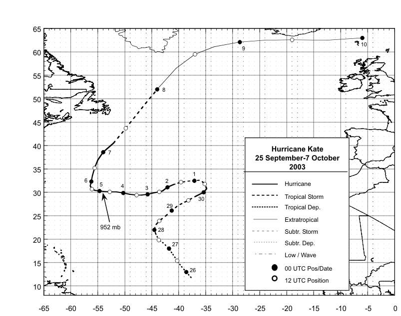
UTC 25 September. The "best track" chart of the tropical cyclone's
path is given in Figure 1, with the wind and pressure histories shown
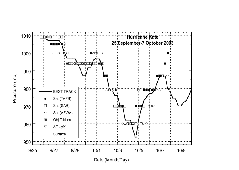
in Figure 2 and Figure 3,
respectively. Table 1 lists the best track
positions and intensities.
The tropical cyclone moved generally northwestward
for a couple of days toward a weakness in the subtropical ridge
over the central Atlantic. Meanwhile, south-southwesterly
upper-level flow caused strong vertical shear over the depression,
and the low-cloud center was intermittently exposed to the
southwest of the main area of deep convection. Around 1800 UTC 27
September, deep convection increased near the center, and
satellite-based estimates indicate that the cyclone became Tropical
Storm Kate. Even though the system continued to experience moderate
southwesterly shearing, it strengthened further over the next two
days while turning northward and northeastward. Kate briefly became
a hurricane, from about 1800 UTC 29 September to 0000 UTC 30
September. Then, while weakening, the cyclone took a hairpin turn
around the eastern side of a mid-tropospheric cyclonic circulation.
By 1 October, Kate was moving west-southwestward on the northern
side of the cyclonic circulation. It also regained hurricane
strength that day. Kate continued west-southwestward for the next
couple of days, guided by the steering flow between an anticyclone
to its north and the cyclonic circulation centered to its south.
There was a relaxation of vertical shear over the area, and as Kate
moved over progressively warmer waters, it strengthened
significantly. By 2 October, a well-defined eye was apparent on
geostationary satellite images. The hurricane moved westward to
west-northwestward over the next couple of days while strengthening
to its peak wind intensity of 110 kt at 1800 UTC 4 October. Kate
was centered about 565 n mi east-southeast of Bermuda at that
time.
Shortly after reaching maximum intensity, the western
portion of the hurricane's central dense overcast became partially
eroded, signifying the beginning of a weakening trend. Also, the
forward speed slowed from 10-11 kt to 6-7 kt as Kate neared the
western periphery of the deep-layer anticyclone that had been
anchored over the north Atlantic for several days. On 5-6 October,
the cyclone turned northward, then accelerated north-northeastward
ahead of a deep-layer trough. Kate was slow to weaken as an eye was
occasionally visible on geostationary satellite imagery. However,
the cyclone finally weakened below hurricane strength on 7 October
while it continued to accelerate north-northeastward over cooler
waters. Kate also began losing tropical characteristics as cold air
clouds wrapped around the center over the southern semicircle, and
the remaining central convection weakened and became disorganized.
The system completed its extratropical transition by 0000 UTC 8
October, but remained a formidable extratropical storm for a couple
more days while moving northeastward to eastward across the
northern Atlantic. It merged with another extratropical low near
Scandinavia on 10 October.
b. Meteorological Statistics
Observations in Hurricane Kate
(Figure 2 and Figure 3)
include satellite-based Dvorak technique intensity estimates from
TAFB, SAB and the U. S. Air Force Weather Agency (AFWA). QuikSCAT
data indicated that Kate had winds of hurricane force from 1800 UTC
29 September to 0000 UTC 30 September. Kate's peak intensity, 110
kt, at 1800 UTC 4 October, is based on a 3-hour average objective
Dvorak T-number of 5.8.
Ship reports of winds of tropical storm force
associated with Hurricane Kate are given in Table 2.
c. Casualty and Damage Statistics
There were no reports of damage or casualties
associated with Kate.
d. Forecast and Warning Critique
Forecasters had a difficult time predicting the path
of this tropical cyclone. Average official track errors (with the
number of cases in parentheses) for Kate were 48 (47), 91 (45), 133
(43), 179 (41), 288 (37), 363 (33), and 406 (29) n mi for the 12,
24, 36, 48, 72, 96, and 120 h forecasts, respectively1.
These errors are greater than the average official
track errors for the 10-yr period 1993-20022
of 45, 81, 116, 150, 225, 282, and 374 n mi,
respectively. Table 3 shows a comparison of the track errors for
various models and the official forecast. Several models, notably
GFDI, AVNI (GFS), and NGPI had lower errors than the official
forecast at practically every forecast period. Interestingly, UKMI,
which is normally an excellent performer, had very large average
errors for Kate. This was due, in part, to a number of UKMI
forecasts thatwhich failed to predict Kate's sharp turn to the
west, and took the system erroneously eastward into the eastern
Atlantic.
Wind speed forecasts for Kate were mostly better than
the long-term means. The average official intensity forecast errors
were 4, 7, 9, 10, 12, 17, and 23 kt for the 12, 24, 36, 48, 72, 96,
and 120 h forecasts, respectively, compared to the average
1993-2002 errors of 6, 10, 13, 15, 19, 21, and 22 kt, respectively.
There was, however, a significant negative bias at 96 and 120
h.
No watches or warnings were required for Kate.
1All forecast verifications in this report include the
depression stage of the cyclone. National Hurricane Center verifications
presented in these reports prior to 2003 did not include the depression
stage.
2 Errors given for the 96 and 120 h periods are averages
over the two-year period 2001-2002.
Table 1: Best track
for Hurricane Kate, 25 September-7 October 2003.
Date/Time
(UTC) | Position | Pressure
(mb) | Wind Speed
(kt) | Stage |
Lat.
(°N) | Lon.
(°W) |
| 25 / 1800 | 11.8 | 37.7 | 1008 | 30 | tropical
depression |
| 26 / 0000 | 12.8 | 38.5 | 1008 | 30 | " |
| 26 / 0600 | 14.0 | 39.4 | 1008 | 30 | " |
| 26 / 1200 | 15.2 | 40.2 | 1007 | 30 | " |
| 26 / 1800 | 16.6 | 41.0 | 1007 | 30 | " |
| 27 / 0000 | 18.0 | 41.8 | 1007 | 30 | " |
| 27 / 0600 | 19.2 | 43.0 | 1007 | 30 | " |
| 27 / 1200 | 20.0 | 43.8 | 1007 | 30 | " |
| 27 / 1800 | 21.0 | 44.2 | 1005 | 35 | tropical
storm |
| 28 / 0000 | 22.0 | 44.5 | 1000 | 45 | " |
| 28 / 0600 | 23.0 | 44.3 | 997 | 50 | " |
| 28 / 1200 | 23.9 | 43.6 | 997 | 50 | " |
| 28 / 1800 | 24.8 | 42.6 | 997 | 50 | " |
| 29 / 0000 | 26.1 | 41.3 | 997 | 50 | " |
| 29 / 0600 | 27.2 | 39.9 | 994 | 55 | " |
| 29 / 1200 | 28.3 | 38.2 | 991 | 55 | " |
| 29 / 1800 | 29.2 | 36.8 | 987 | 65 | hurricane |
| 30 / 0000 | 30.0 | 35.4 | 987 | 65 | " |
| 30 / 0600 | 30.8 | 34.8 | 992 | 55 | tropical
storm |
| 30 / 1200 | 31.8 | 35.1 | 992 | 55 | " |
| 30 / 1800 | 32.6 | 36.0 | 996 | 50 | " |
| 01 / 0000 | 32.5 | 37.1 | 997 | 50 | " |
| 01 / 0600 | 32.4 | 38.3 | 997 | 50 | " |
| 01 / 1200 | 32.2 | 39.6 | 994 | 55 | " |
| 01 / 1800 | 31.7 | 40.9 | 987 | 65 | hurricane |
| 02 / 0000 | 31.1 | 42.1 | 987 | 65 | " |
| 02 / 0600 | 30.3 | 43.0 | 979 | 75 | " |
| 02 / 1200 | 30.1 | 43.6 | 979 | 75 | " |
| 02 / 1800 | 29.9 | 44.7 | 976 | 80 | " |
| 03 / 0000 | 29.6 | 45.8 | 976 | 80 | " |
| 03 / 0600 | 29.4 | 46.9 | 970 | 90 | " |
| 03 / 1200 | 29.4 | 47.8 | 970 | 90 | " |
| 03 / 1800 | 29.6 | 49.1 | 962 | 100 | " |
| 04 / 0000 | 29.9 | 50.3 | 962 | 100 | " |
| 04 / 0600 | 30.1 | 51.6 | 962 | 100 | " |
| 04 / 1200 | 30.1 | 52.8 | 956 | 105 | " |
| 04 / 1800 | 30.2 | 54.0 | 952 | 110 | " |
| 05 / 0000 | 30.3 | 54.7 | 962 | 100 | " |
| 05 / 0600 | 30.4 | 55.5 | 968 | 95 | " |
| 05 / 1200 | 30.7 | 56.1 | 973 | 90 | " |
| 05 / 1800 | 31.4 | 56.4 | 975 | 85 | " |
| 06 / 0000 | 32.3 | 56.2 | 977 | 80 | " |
| 06 / 0600 | 33.5 | 56.0 | 977 | 80 | " |
| 06 / 1200 | 35.2 | 55.6 | 979 | 75 | " |
| 06 / 1800 | 36.9 | 55.0 | 983 | 70 | " |
| 07 / 0000 | 38.6 | 54.0 | 987 | 65 | " |
| 07 / 0600 | 40.5 | 52.1 | 987 | 60 | tropical
storm |
| 07 / 1200 | 43.8 | 49.5 | 987 | 60 | " |
| 07 / 1800 | 47.5 | 47.2 | 980 | 60 | " |
| 08 / 0000 | 52.0 | 44.0 | 978 | 60 | extratropical |
| 08 / 0600 | 56.5 | 40.5 | 974 | 65 | " |
| 08 / 1200 | 59.5 | 37.0 | 974 | 65 | " |
| 08 / 1800 | 61.1 | 33.4 | 970 | 65 | " |
| 09 / 0000 | 62.1 | 28.7 | 970 | 60 | " |
| 09 / 0600 | 62.5 | 24.0 | 972 | 55 | " |
| 09 / 1200 | 62.6 | 19.0 | 973 | 55 | " |
| 09 / 1800 | 62.5 | 12.6 | 976 | 50 | " |
| 10 / 0000 | 63.0 | 6.0 | 980 | 50 | " |
| 10 / 0600 | | | | | merged with extratropical low |
| 04 / 1800 | 30.2 | 54.0 | 952 | 110 | minimum pressure |
Table 2: Selected
ship reports with winds of at least 34 kt for Hurricane Kate, 25
September-7 October 2003.
| Ship Name or Call Sign | Date/Time (UTC) | Lat.
(°N) | Lon.
(°W) | Wind dir/speed (deg/kt) | Pressure (mb) |
| C6QD2 | 28 / 1200 | 23.0 | 42.3 | 180 / 41 | 1008.2 |
| JKES | 07 / 0000 | 36.9 | 52.4 | 180 / 33 | 1007.5 |
| JKES | 07 / 0300 | 37.2 | 53.3 | 220 / 39 | 1007.0 |
| HP6038 | 07 / 0900 | 46.4 | 48.4 | 150 / 35 | 1009.6 |
| VEP717 | 07 / 0900 | 46.7 | 48.7 | 170 / 39 | 1009.1 |
| 3FPK7 | 07 / 0900 | 46.7 | 48.0 | 160 / 40 | 1010.2 |
| 3EXS4 | 07 / 1200 | 40.2 | 50.3 | 250 / 37 | 1008.0 |
| CG2959 | 07 / 1200 | 42.0 | 46.9 | 150 / 35 | 1011.7 |
| ZCBN5 | 07 / 1200 | 43.6 | 44.0 | 150 / 35 | 1015.5 |
| UCTZ | 07 / 1200 | 44.5 | 52.8 | 320 / 39 | 1001.5 |
| HP6038 | 07 / 1200 | 46.4 | 48.4 | 130 / 38 | 1005.6 |
| VEP717 | 07 / 1200 | 46.7 | 48.7 | 160 / 45 | 1004.0 |
| UIC0 | 07 / 1200 | 43.4 | 51.7 | 300 / 33 | 993.3 |
| 3FPK7 | 07 / 1200 | 46.7 | 48.0 | 150 / 40 | 1006.9 |
| 44140 | 07 / 1300 | 43.8 | 51.8 | 300 / 37 | 998.6 |
| 44140 | 07 / 1400 | 43.8 | 51.8 | 300 / 39 | 1002.8 |
| HP6038 | 07 / 1500 | 46.4 | 48.4 | 090 / 50 | 992.1 |
| VEP717 | 07 / 1500 | 46.7 | 48.7 | 120 / 38 | 993.1 |
| 3FPK7 | 07 / 1500 | 46.7 | 48.0 | 120 / 50 | 996.1 |
| 44140 | 07 / 1600 | 43.8 | 51.8 | 300 / 35 | 1008.8 |
| 44551 | 07 / 1600 | 48.4 | 42.4 | 160 / 35 | 1015.3 |
| 44551 | 07 / 1700 | 48.4 | 42.4 | 140 / 35 | 1013.3 |
| ZCBN5 | 07 / 1800 | 43.4 | 42.1 | 150 / 40 | 1016.0 |
| HP6038 | 07 / 1800 | 46.4 | 48.4 | 280 / 44 | 991.7 |
| 3FPK7 | 07 / 1800 | 46.7 | 48.0 | 240 / 40 | 988.9 |
| 44551 | 07 / 1800 | 48.5 | 42.3 | 150 / 39 | 1011.1 |
| 44551 | 07 / 1900 | 48.5 | 42.3 | 130 / 45 | 1008.0 |
| 44551 | 07 / 2000 | 48.6 | 42.3 | 140 / 49 | 1004.9 |
| VEP717 | 07 / 2100 | 46.7 | 48.7 | 320 / 51 | 1006.0 |
| 3FPK7 | 07 / 2100 | 46.7 | 48.0 | 290 / 48 | 1007.8 |
| 44551 | 07 / 2100 | 48.6 | 42.3 | 150 / 47 | 1003.6 |
| 44551 | 07 / 2200 | 48.6 | 42.3 | 190 / 47 | 1004.7 |
| 44551 | 07 / 2300 | 48.6 | 42.3 | 180 / 45 | 1005.2 |
|
Table 3:
Preliminary forecast evaluation (heterogeneous sample) for
Hurricane Kate, 25 September-7 October
2003. Forecast
errors (n mi) are
followed by the number of forecasts in parentheses. Errors smaller
than the NHC official forecast are shown in bold-face
type. Verification
includes the depression stage, but does not include the
extratropical stage, if any.
| Forecast Technique | Period (hours) |
| 12 | 24 | 36 | 48 | 72 | 96 | 120 |
| CLP5 | 71 (47) | 156 (45) | 264 (43) | 383 (41) | 586 (37) | 801 (33) | 1012 (29) |
| GFNI | 46 (34) | 90 (34) | 121 (32) | 138 (30) | 160 (26) | | |
| GFDI | 39 (39) | 62 (38) | 79 (36) | 92 (33) | 193 (29) | 325 (25) | 355 (21) |
| GFDL | 39 (47) | 60 (40) | 70 (36) | 76 (33) | 138 (29) | 264 (25) | 329 (20) |
| GFDN | 52 (21) | 79 (19) | 112 (17) | 137 (16) | 145 (14) | | |
| LBAR | 56 (47) | 109 (45) | 174 (43) | 258 (41) | 524 (37) | 833 (32) | 966 (26) |
| AVNI | 42 (46) | 75 (44) | 99 (42) | 118 (40) | 167 (36) | 260 (32) | 375 (28) |
| AVNO | 47 (47) | 71 (45) | 92 (43) | 105 (41) | 146 (37) | 228 (33) | 326 (29) |
| AEMI | 46 (27) | 81 (27) | 119 (27) | 167 (26) | 283 (23) | 333 (19) | 534 (14) |
| BAMD | 53 (47) | 101 (45) | 158 (43) | 226 (41) | 538 (37) | 994 (33) | 1615 (28) |
| BAMM | 58 (47) | 102 (45) | 145 (43) | 185 (41) | 295 (37) | 520 (33) | 837 (29) |
| BAMS | 71 (47) | 125 (45) | 177 (43) | 226 (41) | 344 (37) | 540 (33) | 773 (29) |
| NGPI | 50 (43) | 87 (41) | 123 (39) | 145 (37) | 161 (33) | 223 (29) | 329 (24) |
| NGPS | 56 (44) | 82 (42) | 120 (40) | 148 (38) | 189 (34) | 241 (30) | 321 (25) |
| UKMI | 67 (44) | 128 (43) | 200 (41) | 289 (39) | 479 (35) | 691 (27) | 902 (23) |
| UKM | 69 (23) | 121 (22) | 175 (21) | 241 (20) | 411 (18) | 580 (14) | 836 (12) |
| A98E | 59 (47) | 116 (45) | 164 (43) | 249 (41) | 510 (37) | 873 (33) | 1351 (29) |
| A9UK | 50 (22) | 120 (22) | 171 (21) | 263 (20) | 475 (18) | | |
| GUNS | 43 (36) | 77 (35) | 110 (33) | 148 (31) | 244 (27) | 373 (21) | 425 (16) |
| GUNA | 41 (36) | 72 (35) | 99 (33) | 132 (31) | 214 (27) | 336 (21) | 415 (16) |
| OFCL | 48 (47) | 91 (45) | 133 (43) | 179 (41) | 288 (37) | 363 (33) | 406 (29) |
| NHC Official (1993-2002 mean) | 45 (2985) | 81 (2726) | 116 (2481) | 150 (2230) | 225 (1819) | 282 (265) | 374 (216) |
|

Figure 1:
Best track positions for
Hurricane Kate, September/October 2003. Track during the
extratropical stage is based on analyses from the
NOAA Ocean
Prediction Center.
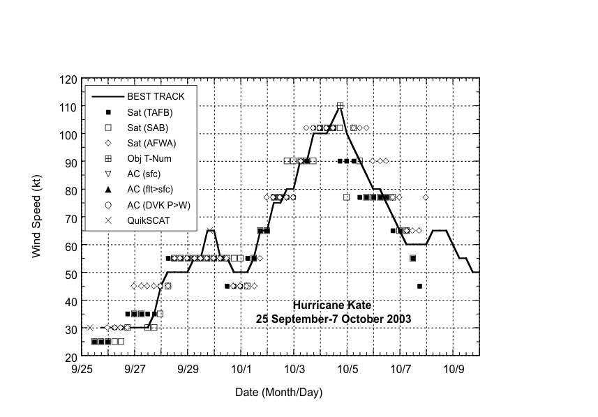
Figure 2:
Selected wind
observations and best track maximum sustained surface wind speed
curve for Hurricane Kate, 25 September - 7 October 2003. Objective
Dvorak estimates represent linear averages over a three-hour period
centered on the nominal observation time. Estimates during the
extratropical stage are based on analyses from the
NOAA Ocean
Prediction Center.

Figure 3:
Selected pressure
observation s and best track minimum central pressure curve for
Hurricane Kate, 25 September - 7 October 2003. Objective Dvorak
estimates represent linear averages over a three-hour period
centered on the nominal observation time. Estimates during the
extratropical stage are based on analyses from the
NOAA Ocean
Prediction Center.
|