Tropical Cyclone Report
Hurricane Juan
24 - 29 September 2003
Lixion. A. Avila
National Hurricane Center
7 November 2003
Revised: 12 May 2004
Juan made landfall near Halifax, Nova Scotia as a
category two hurricane on the Saffir-Simpson Hurricane Scale, and
will be recorded as one of the most damaging tropical cyclones in
modern history for Halifax.
a. Synoptic History
The formation of Hurricane Juan was rather complex.
Its origin was a large tropical wave accompanied by a broad area of
low pressure that moved off the coast of Africa on 14 September and
continued westward over the tropical Atlantic. On 20 September, the
shower activity increased significantly but remained disorganized.
By then, the wave was located about 600 n mi east of the Lesser
Antilles and interacting with the circulation of a large
upper-level low. This low was partially associated with the outflow
of powerful Hurricane Isabel, then located well to the northwest,
and the mid-oceanic upper-level trough. The wave spawned a
middle-level circulation that moved northwestward away from the
Lesser Antilles around the upper-low and then interacted with a
frontal zone. A low-level circulation developed late on the
23rd, but there was not enough organized convection to
classify the system as a tropical depression. The disturbance had
some extratropical characteristics since it appeared to be attached
to the frontal zone. However, it made the transition to a tropical
cyclone, when the deep convection increased near the center and the
cyclone developed banding features with a distinct outflow. It is
estimated that a tropical depression formed at 1200 UTC 24
September, about 300 n mi southeast of Bermuda. The cyclone reached
tropical storm status by 0000 UTC September 25. The cloud pattern
continued to organize and the cyclone developed an eye, becoming a
hurricane by 1200 UTC 26 September.
Juan moved toward the north and then toward the
northwest as the subtropical ridge to the northeast of the cyclone
briefly expanded westward. The cyclone gradually intensified and
reached its maximum intensity of 90 knots, with a minimum pressure
of 969 mb, at 1800 UTC 27 September. Juan then turned northward
again, with an increase in forward speed, and made landfall near
Halifax, Nova Scotia, between Prospect and Peggy's Cove around 0300
UTC 29 September with estimated 1-min sustained winds of 85 knots
and a minimum pressure of 973 mb. The cyclone weakened, but it
crossed Nova Scotia as a hurricane and retained its tropical
characteristics as it moved over Prince Edward Island. It became
absorbed by a large extratropical low by 1800 UTC 29 September in
the Gulf of St. Lawrence.
The "best track" chart of the tropical cyclone's path
is given in Figure 1,
with the wind and pressure histories shown in
Figure 2 and Figure 3,
respectively. The best track positions and
intensities are listed in Table 1.
b. Meteorological Statistics
Observations in Hurricane Juan
(Figure 2 and Figure 3)
primarily consists of satellite-based Dvorak technique intensity
estimates from the Tropical Analysis and Forecast Branch (TAFB),
the Satellite Analysis Branch (SAB) and the U.S. Air Force Weather
Agency (AFWA). Ship and buoy observations and surface reports of
winds of tropical storm force or higher associated with Juan are
given in Table 2 and Table 3, respectively.
A post-analysis of satellite imagery, scatterometer
winds, AMSU data, ship and drifting buoy observations indicate that
Juan had reached tropical storm strength by 0000 UTC 25 September.
Data from a QuikSCAT pass at 0925 UTC 25 September (indicated by an
X in Figure 2) suggest that the winds associated with Juan were
between 40 and 45 knots. AMSU data were used to classify the
cyclone as tropical since it showed a weak warm core at the mid- to
upper levels of the cyclone. In addition, as the developing center
passed near the drifting buoy 41537, the surface pressure dropped
to 992.6 mb at 2000 UTC from 996.6 mb at 1800 UTC. This suggested
that Juan had the tight inner core of a tropical cyclone.
Operationally, Juan was upgraded to hurricane status based on the
development of an eye feature on both visible and infrared
satellite imagery, and AMSU data that suggested winds of 66 knots
and a minimum pressure of 985 mb. However, because the convection
was not very deep at such high latitude, the Dvorak intensity
estimates did not support 65 knots at that time (Figure 2).
The center of Juan passed over a Canadian buoy
(44142) between 2300 UTC 28 September and 0000 UTC 29 September,
producing a wind change from the east at 54 knots to the southwest
at 37 knots. The buoy pressure dropped to 974.7 mb.
The estimated intensity of 85 knots at landfall was
primarily based on a report from McNab's Island, a small piece of
land in Halifax Harbor. An anemometer at this location reported
2-min sustained wind of 81 knots. While the instrument is located
at 10 m above the surface, the station elevation is 17 m above sea
level. It is therefore possible that this measurement may not be
fully representative of a surface winds. In addition, there was on
an oil rig observation (not included on Table 3) in Halifax Harbor
of sustained winds near 99 knot but at an elevation of 62 m. The
instrument stopped recording at 99 knots. The intensity at landfall
of 85 knots is in agreement with the estimates obtained by
meteorologists from the Canadian Hurricane Center (CHC).
It is interesting to note that the wind field
associated with Juan was not symmetric, probably because the
transition to extratropical was beginning to take place. Wind
reports provided by CHC indicate that wind gusts west of the track
of Juan were half values of those to the right of its track. Radar
observations from Halifax indicate that the eye diameter at
landfall was 18 n mi.
c. Casualty and Damage Statistics
The last time that the city of Halifax was hit by the
eyewall of a hurricane was 22 August, 1893. Juan will be recorded
as one of the most damaging tropical cyclones in modern history for
Halifax, N.S. Damage included widespread falling trees, power
outages and damaged homes.
Hundred of Maritimers in Nova Scotia and Prince
Edward Island lost power.
There were four direct deaths (two inland and two marine) associated with
Juan. In addition, four indirect deaths occurred in the aftermath.
Halifax Harbor recorded an all time record
water level of 4.9 feet above the normal tide levels, which
resulted in extensive flooding of the Halifax and Dartmouth
waterfront properties. The building where the CHC is located was
also damaged.
d. Forecast and Warning Critique
The average official track errors for Juan were 38,
63, 87, 108, 61 and 129 n mi for the 12, 24, 36, 48, 72 and 96 h
forecasts, respectively1.
Juan did not last long enough to verify any 120-h
forecasts. These errors are much lower than the average official
track errors for the 10-yr period 1993-20022 of 45, 81,
116, 150, 225 and 282 n mi, respectively. Table 4 includes a
summary of track guidance during Juan.
Average official intensity errors were 8, 13,16, 20,
20 and 10 kt for the 12, 24, 36, 48, 72 and 96 h forecasts,
respectively. The intensity errors were a bit higher than the
average official intensity errors over the 10-yr period
1993-20022 of 6, 10, 13, 15, 19 and 21 kt,
respectively.
It is rather difficult to determine accurately if a
cyclone is tropical, subtropical or extratropical when
characteristics of these various cyclone types are present, and
Juan was no exception. The decision to classify the cyclone
tropical was heavily based on AMSU data which showed a weak warm
core at the mid- to upper levels of the cyclone. Advisories on the
tropical depression were initiated on 25 September. Operationally,
there was not enough evidence of a closed circulation and
organization to start advisories on the 24th. However, a
post-analysis using scatterometer data from 0925 UTC 25 September,
suggested that Juan had a well-defined closed circulation at that
time. This data has led us to assume that there was enough
circulation for Juan to be classified as a tropical depression on
the 24th, as indicated in the best track
Juan was forecast to reach Nova Scotia as a 65- to
70-kt hurricane. However, it did so with 85 knots. The fact that
Juan maintained its tropical characteristics longer than
anticipated continues to reflect the uncertainties and the limited
skill in predicting the timing of the extratropical transition.
Historically, most of the tropical cyclones affecting Nova Scotia
are in their transition to an extratropical low. It was stated in
the tropical cyclone discussions from the time of Juan's formation
that the cyclone would likely retain its tropical characteristics
at landfall. This was because Juan was forecast to spend little
time over cool waters as it moved rapidly toward Nova Scotia .
A tropical storm warning was issued for Bermuda at
21,00 UTC 25 September and was discontinued at 1800 UTC 26
September. The CHC does not issue coastal hurricane warnings.
Instead, a rain and high wind warning was issued for portions of
Nova Scotia, Prince Edward Island and the marine areas.
Acknowledgments:
Most of the data and damage reports have been
provided by meteorologists from the Canadian Hurricane center. A
more detailed of the local effects in Nova Scotia can be found the
web page of the Environment Canada Hurricane Center at:
http://www.atl.ec.gc.ca/weather/hurricane/index_e.html
1
All forecast verifications in this report include the depression stage of the
cyclone. National Hurricane Center verifications presented in these reports
prior to 2003 did not include the depression stage.
2
Errors given for the 96 h periods are averaged over the two-year
period 2001-2002.
Table 1: Best track for Hurricane Juan, 24-29 September
2003.
Date/Time
(UTC) | Position | Pressure
(mb) | Wind Speed
(kt) | Stage |
Lat.
(°N) | Lon.
(°W) |
| 24 / 1200 | 28.2 | 62.4 | 1009 | 25 | tropical
depression |
| 24 / 1800 | 28.3 | 62.2 | 1007 | 30 | " |
| 25 / 0000 | 28.4 | 62.0 | 1006 | 35 | tropical
storm |
| 25 / 0600 | 28.8 | 61.7 | 1002 | 40 | " |
| 25 / 1200 | 29.2 | 61.4 | 1000 | 45 | " |
| 25 / 1800 | 30.4 | 61.6 | 996 | 50 | " |
| 26 / 0000 | 30.9 | 61.8 | 992 | 55 | " |
| 26 / 0600 | 31.1 | 61.8 | 990 | 60 | " |
| 26 / 1200 | 31.8 | 62.0 | 987 | 65 | hurricane |
| 26 / 1800 | 32.5 | 62.0 | 987 | 70 | " |
| 27 / 0000 | 33.3 | 62.0 | 984 | 75 | " |
| 27 / 0600 | 34.4 | 62.2 | 981 | 75 | " |
| 27 / 1200 | 35.2 | 62.8 | 979 | 75 | " |
| 27 / 1800 | 35.5 | 63.2 | 969 | 90 | " |
| 28 / 0000 | 36.3 | 63.6 | 970 | 90 | " |
| 28 / 0600 | 37.1 | 64.0 | 970 | 90 | " |
| 28 / 1200 | 38.5 | 64.1 | 970 | 90 | " |
| 28 / 1800 | 40.2 | 64.1 | 970 | 90 | " |
| 29 / 0000 | 42.8 | 63.9 | 972 | 85 | " |
| 29 / 0600 | 46.0 | 63.8 | 982 | 65 | " |
| 29 / 1200 | 49.8 | 62.4 | 995 | 45 | tropical
storm |
| 29 / 1800 | | | | | absorbed |
| 27 / 1800 | 35.5 | 63.2 | 969 | 90 | minimum pressure |
| 29 / 0300 | 44.4 | 63.8 | 973 | 85 | landfall near Halifax, Nova Scotia |
Table 2: Selected ship and buoy reports with winds of at
least 34 kt for Hurricane Juan, 24-29 September 2003.
| Ship Name or Call Sign | Date/Time (UTC) | Lat.
(°N) | Lon.
(°W) | Wind dir/speed (deg/kt) | Pressure (mb) |
| 41537 | 24 / 2110 | 30.3 | 61.5 | *** / 47 | 1014.9 |
| 41537 | 25 / 0310 | 30.3 | 61.5 | *** / 43 | 1014.8 |
| 41537 | 25 / 0410 | 30.3 | 61.5 | | 1014.3 |
| 41537 | 25 / 0810 | 30.4 | 61.6 | *** / 51 | 1011.4 |
| 41537 | 25 / 1510 | 30.4 | 61.6 | *** / 52 | 007.9 |
| WCY533 | 28 / 1800 | 43.8 | 60.3 | 120 / 36 | 1019.2 |
| WCY533 | 28 / 2100 | 43.8 | 60.3 | 120 / 38 | 1017.2 |
| 44137 | 28 / 2200 | 42.3 | 62.0 | 130 / 35 | 1009.2 |
| 44142 | 28 / 2200 | 42.5 | 64.0 | 080 / 41 | 995.8 |
| 44137 | 28 / 2300 | 42.3 | 62.0 | 130 / 35 | 1007.9 |
| 44142 | 28 / 2300 | 42.5 | 64.0 | 090 / 54 | 981.0 |
| WCY533 | 29 / 0000 | 43.8 | 60.3 | 120 / 45 | 1015.2 |
| 44137 | 29 / 0000 | 42.3 | 62.0 | 150 / 41 | 1008.3 |
| 44142 | 29 / 0000 | 42.5 | 64.0 | 210 / 37 | 974.7 |
| 44137 | 29 / 0100 | 42.3 | 62.0 | 170 / 37 | 1009.8 |
| 44142 | 29 / 0100 | 42.5 | 64.0 | 220 / 37 | 993.3 |
| 44258 | 29 / 0200 | 44.5 | 63.4 | 070 / 39 | 1000.8 |
| VOCJ | 29 / 0300 | 44.7 | 63.6 | 130 / 49 | 982.9 |
| 44258 | 29 / 0300 | 44.5 | 63.4 | 100 / 47 | |
| VOCJ | 29 / 0400 | 44.7 | 63.6 | 160 / 48 | 981.1 |
| VOGT | 29 / 0600 | 46.1 | 61.5 | 130 / 60 | 1006.5 |
|
Table 3: Selected surface observations for Hurricane Juan,
24-29 September, 2003
| | Minimum
Sea-level
Pressure | Maximum Surface Wind Speed
(kt) | |
| Location | Date/
Time
(UTC) | Press.
(mb) | Date/
Timea
(UTC) | Sust.
Windb
(kts) | Peak
Gust (kts) | Storm
Surgec
(ft) | Storm
Tided
(ft) | Rain
(storm total)
(in) |
| Nova Scotia, Canada |
| Shearwater | 29/0400 | 987.5 | 29/0349 | 54 | 70 | 4.9 | 9.5 | 2.20 |
| McNabs's Island | 29/0400 | 982.1 | 29/0324 | 81 | 95 | | | |
| Halifax Int. Air | 29/0400 | 987.4 | 29/0404 | 54 | 77 | | | 2.90 |
| Beaver Island | 29/0440 | 998.3 | 29/0440 | 55 | 71 | | | |
| Lunenburg | 29/0400 | 990.2 | 29/02002320 | 36 | 57 | | | |
| Caribou Point | 29/0546 | 996.3 | 29/0546 | 46 | 64 | | | 0.70 |
| Confederation Bridge | 29/0600 | 984.9 | 29/0600 | 60 | 74 | | | |
| Hart Island, NS | 29/0600 | 1010.1 | 29/06403737 | 46 | | | | |
| CHC (West of CYAW) | 29/0310 | 984.3 | | | | | | 3.40 |
| Prince Edward Island, Canada |
| North Cape | 29/0800 | 989.6 | 29/0700 | 37 | 48 | | | |
| Charlottetown | 29/0700 | 991.2 | 29/0617 | 50 | | 4.1 | 9.6 | 0.80 |
| East Point | 29/0700 | 1000.8 | 29/0700 | 36 | 52 | | | 0.25 |
| | | | | | | | |
| Iles de la Madeleine | 29/0800 | 1000.6 | 29/0900 | 40 | 58 | | | |
aDate/time is for wind gust when both sustained and gust are listed.
bExcept as noted, sustained wind averaging periods for C-MAN and land-based ASOS reports are
2 min; buoy averaging periods are 8 min.
cStorm surge is water height above normal astronomical tide level.
dStorm tide is water height above National Geodetic Vertical Datum (1929 mean sea level).
aDate/time is for sustained wind when both sustained and gust are
listed.
breports is 2- min sustained.
cStorm surge is water height
above normal astronomical tide level.
dStorm
tide is water height above National Geodetic Vertical Datum (1929
mean sea level). |
Table 4: Preliminary forecast evaluation (heterogeneous
sample) for Hurricane Juan, 24-29 September.
Forecast errors (n mi) are followed by
the number of forecasts in parentheses. Errors smaller than the NHC
official forecast are shown in bold-face type.
Verification includes the depression stage, but does not
include the extratropical stage.
| Forecast Technique | Period (hours) |
| 12 | 24 | 36 | 48 | 72 | 96 | 120 |
| CLP5 | 67 (16) | 165 (14) | 255 (12) | 330 (10) | 532 (6) | 746 (2) | |
| GFNI | 30 (10) | 64 (10) | 109 (9) | 157 (7) | 133 (3) | | |
| GFDI | 31 (12) | 49 (12) | 63 (10) | 83 (8) | 105 (4) | 146 (1) | |
| GFDL | 31
(15) | 47 (13) | 51 (11) | 59 (9) | 74 (5) | 165 (1) | |
| GFDN | 33 (7) | 48 (6) | 67 (5) | 125 (4) | 81 (2) | | |
| LBAR | 39 (16) | 78 (14) | 91 (12) | 98 (10) | 200 (6) | 608 (2) | |
| AVNI | 33 (12) | 48 (11) | 52 (9) | 70 (7) | 95 (3) | | |
| AVNO | 47 (14) | 58 (12) | 58 (10) | 54 (8) | 87 (4) | | |
| AEMI | 42 (7) | 81 (7) | 89 (6) | 240 (4) | 429 (2) | 857 (1) | |
| BAMD | 44 (16) | 72 (14) | 87 (12) | 88 (10) | 107 (6) | 218 (2) | |
| BAMM | 40 (16) | 66 (14) | 72
(12) | 76
(10) | 177 (6) | 343 (2) | |
| BAMS | 45 (16) | 80 (14) | 101 (12) | 140 (10) | 264 (6) | 469 (2) | |
| NGPI | 28
(13) | 67 (11) | 110 (9) | 125 (7) | 155 (3) | | |
| NGPS | 29 (14) | 49 (12) | 84 (10) | 111 (8) | 99 (4) | | |
| UKMI | 44 (12) | 90 (12) | 148 (10) | 188 (8) | 336 (4) | | |
| UKM | 88 (8) | 123 (7) | 137 (6) | 198 (4) | 247 (3) | 1021 (1) | |
| A98E | 47 (16) | 91 (14) | 88 (12) | 88 (10) | 147 (6) | 485 (2) | |
| A9UK | 41 (9) | 91 (8) | 115 (7) | 146 (6) | 260 (4) | | |
| GUNS | 29 (11) | 60 (11) | 98 (9) | 120 (7) | 109 (3) | | |
| GUNA | 27 (11) | 49 (11) | 81 (9) | 92 (7) | 75 (3) | | |
| OFCL | 38 (15) | 63 (13) | 87 (11) | 108 (9) | 61 (5) | 229 (1) | |
| NHC Official (1993-2002 mean) | 45 (2985) | 81 (2726) | 116 (2481) | 150 (2230) | 225 (1819) | 282 (265) | |
|
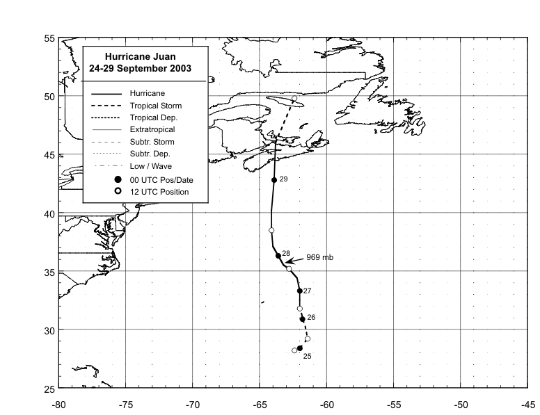
Figure 1: Best track
positions for Hurricane Juan, 24-29 September, 2003. Track after
landfall was based on analyses from the Canadian Hurricane
Center.
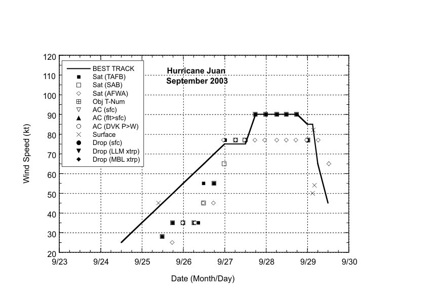
Figure 2: Selected wind
observations and best track maximum sustained surface wind speed
curve for Hurricane Juan, 24-29 September, 2003.
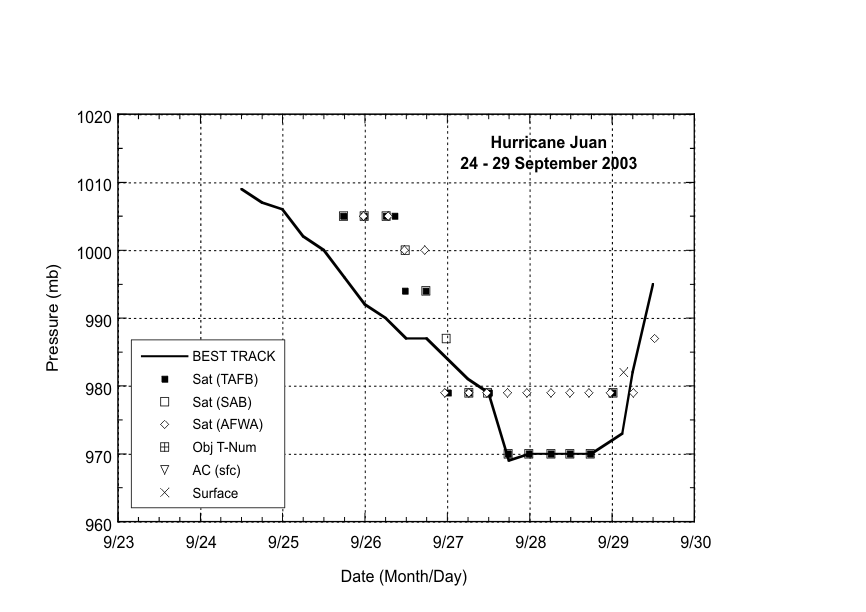
Figure 3: Selected pressure
observations and best track minimum central pressure curve for
Hurricane Juan, 24-29 September, 2003.
|


