Tropical Cyclone Report
Hurricane Erika
14 - 17 August 2003
James L. Franklin
National Hurricane Center
17 November 2003
Erika made landfall in extreme northeastern Mexico
shortly after reaching hurricane strength. The hurricane was
responsible for two deaths.
a. Synoptic History
Erika's origin was non-tropical. A weak surface low
detached from a decaying frontal system about 1000 n mi east of
Bermuda on 8 August. This low moved southwestward, and late on 9
August convection flared up when the surface system passed
underneath the northern portion of an upper-level cold low about
650 n mi southeast of Bermuda. The two systems appeared to revolve
around a common center while the complex moved generally westward,
and by 11 August, the surface low had become a trough/vorticity
maximum located to the south of the upper-level low about 400 n mi
south of Bermuda. This configuration was maintained as the
disturbed weather continued westward at 15-20 kt over the next
three days. During this time, most of the deep convection was
occurring well north of the low-level vorticity maximum near the
center of the upper low. This distribution of convection, along
with the rapid motion of the system, helped prevent the development
of a closed surface circulation.
Late on 13 August, when the system was just east of
the northwestern Bahamas, there was a substantial increase in
convection around the center of the upper low. The low built
downward to the middle levels, developing an anticyclone aloft as
it became better organized. Near 0000 UTC 14 August, there was an
unofficial report of a 51 kt wind gust on Abaco Island. Convection
remained vigorous while the system neared Florida during the
morning of 14 August, and a closed circulation nearly developed
down to the surface in the southern part of the system east of Key
Largo around 0800 UTC that day. However, this feature weakened,
while convection was being maintained in the northern, mid-level
portion of the disturbance as it moved across the Florida
peninsula. It was out of this mid-level circulation that a closed
surface low finally formed near 1800 UTC, about 75 n mi west of Ft.
Myers, Florida. With winds already of tropical storm strength, the
system immediately became Tropical Storm Erika.
The "best track" chart of Erika's path is given in
Figure 1,
with the wind and pressure histories shown in
Figure 2 and Figure 3,
respectively. The best track positions and intensities are
listed in Table 1. A strong deep-layer high pressure system over
the south-central United States helped initially steer Erika
westward at about 22 kt. As the cyclone's central convection
intensified and the low-level circulation became better defined
late on 14 August, Erika strengthened. Gradual strengthening
continued on 15 August while Erika's forward speed began to slow
and its convection took on a more banded structure. By late in the
day, an eye was visible in land-based radar imagery and Erika's
winds neared hurricane strength. Erika began to outpace the
deep-layer high, which had also been moving westward, and early on
16 August Erika's forward speed slowed further, to about 13 kt.
Erika became a hurricane and reached its maximum intensity at
landfall near1030 UTC 16 August about 40 miles south of Matamoros,
Mexico, near Boca San Rafael. The hurricane weakened rapidly after
landfall and dissipated shortly after 0000 UTC 17 August over the
mountains of northeastern Mexico.
b. Meteorological Statistics
Observations in Erika (Figure 2 and Figure 3)
include
satellite-based Dvorak technique intensity estimates from the
Tropical Analysis and Forecast Branch (TAFB), the Satellite
Analysis Branch (SAB) and the U. S. Air Force Weather Agency
(AFWA), as well as flight-level and dropwindsonde observations from
flights of the 53rd Weather Reconnaissance Squadron of
the U. S. Air Force Reserve Command.
Despite an impressive and organized appearance on
satellite imagery, the rapid westward motion of the pre-Erika
disturbance hindered the development of a closed surface
circulation. Data from reconnaissance aircraft, including
dropsondes, were instrumental in determining when the disturbance
had finally become a tropical cyclone. Around 0800 UTC 14 August,
aircraft flight-level data at 850 mb indicated the presence of a
closed circulation just east of Key Largo, Florida. However a
dropsonde revealed that the west winds measured by the aircraft
were not present below flight level and advisories were not
initiated until later in the day, when a new low-level circulation
formed within the system over the eastern Gulf of Mexico.
Erika was never upgraded to a hurricane
operationally. The highest flight-level observations from
reconnaissance aircraft were 67 and 66 kt at 0213 UTC and 0820 UTC
16 August, respectively. These observations were made at 700 mb,
and correspond to a surface wind of about 60 kt (the operational
landfall intensity). Tropical Cyclone Discussions issued at the
time of landfall mentioned strong winds being observed by the
Brownsville Doppler radar, and suggested the possibility that Erika
had reached hurricane strength prior to landfall. A post-storm
review of the Doppler data revealed winds in excess of 85 kt over
an area several miles across, in the eastern and northeastern (over
water) portion of the eyewall near the time of landfall, from
around 1000-1200 UTC at an elevation of about 2500 ft. Adjustment
of these (85 kt) winds to the surface using the mean eyewall wind
profile gives a surface wind estimate of 65 kt. Unfortunately,
there were no aircraft reconnaissance observations in this part of
the cyclone after 0820 UTC. However, on the basis of the radar
observations, Erika has been posthumously upgraded to a hurricane.
A pressure fall of at least 5 mb after the time of the 67 kt
flight-level wind also suggests that Erika likely reached hurricane
intensity. The estimated minimum pressure (986 mb) was determined
by extrapolation of the pre-landfall deepening rate to the time of
landfall.
Marine reports of winds of tropical storm force
associated with Erika are given in Table 2, and selected surface
observations from land stations and data buoys are given in
Table 3.
As is normally the case, land observations were inadequate to
document Erika's highest winds. The strongest sustained wind
observed over land was 35 kt (10-min mean) at San Fernando, Mexico,
with a gust to 55 kt. In south Texas, sustained tropical storm
force winds were observed in Brownsville.
In Magueyes, Mexico, 6.71 in of rain was recorded. A
number of other sites reported storm total rainfall of 3 in or
more. In south Texas, official and co-operative observing sites
reported rainfall totals of less than 2 in, although unofficial
reports of 2-3 in were also received from the Brownsville area.
Doppler radar estimated isolated accumulations of 4-6 in in Kenedy
and Brooks counties.
c. Casualty and Damage Statistics
Two persons died in Montemorelos, Mexico, when they
tried to cross a bridge that was partially under water and their
truck was swept away by flood waters. Damage to roofs and cars was
reported in Matamoros, and numerous highways in northeastern Mexico
were blocked by mud slides.
Only isolated minor damage was reported in south
Texas. Minor coastal flooding and beach erosion occurred on South
Padre Island, and there was also a report of one roof being
damaged. There were no injuries or fatalities reported in the
United States.
d. Forecast and Warning Critique
Forecast accuracy for Erika was better than the
long-term average. Average official track errors (with the number
of cases in parentheses) for Erika were 31 (8), 59 (6), 73 (4), and
102 (2) n mi for the 12, 24, 36, and 48h forecasts,
respectively1.
These errors are considerably lower that the average
official track errors for the 10-yr period 1993-2002 (45, 81, 116,
and 150 n mi, respectively). Average official intensity errors were
3, 4, 9, and 15 kt for the 12, 24, 36, and 48 h forecasts,
respectively. For comparison, the average official intensity errors
over the 10-yr period 1993-2002 are 6, 10, 13, and 15 kt,
respectively.
Table 4 lists the watches and warnings associated
with Erika. A hurricane watch was issued at 0300 UTC 15 August,
about 31 hours prior to landfall. A hurricane warning was issued at
1500 UTC 15 August, or about 19 hours prior to landfall. The center
of Erika came ashore roughly in the center of the hurricane warning
area.
Acknowledgments:
The Meteorological Service of Mexico, as well as the
National Weather Service Forecast Offices in Brownsville and Corpus
Christi contributed observations included in this report. Colin
McAdie of the Tropical Prediction Center performed the analysis of
the Doppler radar data that resulted in Erika's upgrade to a
hurricane.
1All forecast verifications in this report include the
depression stage of the cyclone. National Hurricane Center verifications
presented in these reports prior to 2003 did not include the depression
stage.
Table 1: Best track for Hurricane Erika, 14-17 August
2003.
Date/Time
(UTC) | Position | Pressure
(mb) | Wind Speed
(kt) | Stage |
Lat.
(°N) | Lon.
(°W) |
| 14 / 1800 | 26.4 | 83.3 | 1011 | 35 | tropical
storm |
| 15 / 0000 | 26.6 | 85.7 | 1008 | 40 | " |
| 15 / 0600 | 26.4 | 88.3 | 1008 | 40 | " |
| 15 / 1200 | 26.1 | 90.5 | 1007 | 45 | " |
| 15 / 1800 | 26.0 | 92.5 | 1001 | 50 | " |
| 16 / 0000 | 25.9 | 94.4 | 995 | 55 | " |
| 16 / 0600 | 25.6 | 96.2 | 988 | 60 | " |
| 16 / 1200 | 25.2 | 97.6 | 988 | 65 | hurricane |
| 16 / 1800 | 24.8 | 98.9 | 1003 | 35 | tropical
storm |
| 17 / 0000 | 24.7 | 100.3 | 1008 | 25 | tropical
depression |
| 17 / 0600 | | | | | dissipated |
| 16 / 1030 | 25.3 | 97.4 | 986 | 65 | landfall near Boca San Rafael, Mexico, and minimum pressure |
Table 2: Selected ship reports with winds of at least 34 kt
for Hurricane Erika, 14-17 August 2003.
| Ship Name or Call Sign | Date/Time (UTC) | Lat.
(°N) | Lon.
(°W) | Wind dir/speed (deg/kt) | Pressure (mb) |
| WGXO | 15 / 0200 | 28.2 | 86.8 | 070 / 38 | 1016.2 |
| WGXO | 15 / 0300 | 28.1 | 86.4 | 080 / 37 | 1016.4 |
| HP9685 | 15 / 0900 | 27.2 | 90.8 | 020 / 35 | 1013.9 |
| HP9685 | 15 / 1200 | 27.2 | 90.8 | 080 / 40 | 1010.6 |
|
Table 3: Selected surface observations for Hurricane Erika,
14-17 August 2003.
| | Minimum
Sea-level
Pressure | Maximum Surface Wind Speed
(kt) | |
| Location | Date/
Time
(UTC) | Press.
(mb) | Date/
Timea
(UTC) | Sust.
Windb
(kts) | Peak
Gust (kts) | Storm
Surge
(ft) | Storm
Tide
(ft) | Rain
(storm total)
(in) |
| Texas |
| Brownsville
(BRO) | 16/10043 | 1002.6 | 16/0947 | 34 | 41 | | | 1.11 |
| Valley Intl Airpt (HRL) | 16/1143 | 1007.2 | 16/1143 | 27 | 35 | | | 0.52 |
| McAllen/Miller (MFE) | 16/1113 | 1009.7 | 16/0954 | 27 | 35 | | | 1.15 |
| Bayview (PIL) | 16/0930 | 1005.3 | 16/0956 | 30 | 38 | | | 0.82 |
| Los Fresnos (Co-op) | | | | | | | | 1.65 |
| Port Mansfield (Co-op) | | | | | | | | 1.46 |
| Raymondville (Co-op) | | | | | | | | 1.58 |
| Sarita (Co-op) | | | | | | | | 1.05 |
| Falfurrias (Co-op) | | | | | | | | 1.09 |
| Buoys |
| 42020 | 16/1000 | 1009.4 | 16/0600 | | 41 | | | |
| 42002 | 16/0100 | 1009.3 | 16/0030 | 34 | 42 | | | |
| Texas Coastal Oceanic Observing Network |
| Bob Hall Pier | | | 16/1400 | | 35 | | | |
| Bird Island | | | 16/1300 | | 35 | | | |
| Baffin Bay | | | 16/1300 | | 34 | | | |
| Port Isabel | | | 16/0800 | | 44 | | | |
| S. Padre Is. CG Stn | | | 16/0800 | 36d | 46 | | | |
| Texas Tech Tower |
| Port Isabel | | | 16/0903 | 32 | 41 | | | |
| Mexico |
| Matamoros | 16/1010 | 1002.3 | 16/0900 | 28c | 39 | | | 0.32 |
| San
Fernando | | | 16/1350 | 35c | 55 | | | 2.76 |
| El Cuchillo | | | | | | | | 0.83 |
| Magueyes | | | | | | | | 6.71 |
| Presa Cerro Prieto | | | | | | | | 4.02 |
| Camacho | | | | | | | | 3.54 |
| Presa La Boca | | | | | | | | 3.47 |
| Monterrey Obs | | | | | | | | 3.42 |
| El Barretal | | | | | | | | 2.93 |
aDate/time is for sustained wind when both
sustained and gust are listed.
bExcept
as noted, sustained wind averaging periods for C-MAN and land-based
ASOS reports are 2 min; buoy averaging periods are 8 min.
c10-min average.
dAveraging period unknown. |
Table 4: Watch and warning summary for Hurricane Erika,
14-17 August 2003.
| Date/Time | Action | Location |
| 15 / 0300 | Hurricane Watch issued | Brownsville to Port O'Connor |
| 15 / 0300 | Hurricane Watch issued | Boca Santa Maria to US/MX border |
| 15 / 0900 | Tropical Storm Warning issued | Brownsville to Port O'Connor |
| 15 / 0900 | Hurricane Watch modified | Soto La Marina to US/MX border |
| 15 / 1500 | Tropical Storm Warning modified | Baffin Bay to Port O'Connor |
| 15 / 1500 | Hurricane Watch discontinued | All |
| 15 / 1500 | Hurricane Warning issued | Brownsville to Baffin Bay |
| 15 / 1500 | Hurricane Warning issued | La Pesca to US/MX border |
| 16 / 1300 | Tropical Storm Warning discontinued | All |
| 16 / 1300 | Hurricane Warning discontinued | Brownsville to Baffin Bay |
| 16 / 1500 | Hurricane Warning changed to Tropical Storm
Warning | La Pesca to US/MX border |
| 16 / 1800 | Tropical Storm Warning discontinued | All |
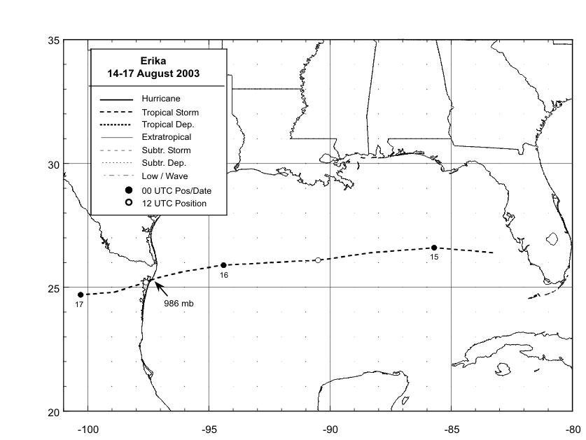
Figure 1:
Best track
positions for Hurricane Erika, 14-17 August 2003.
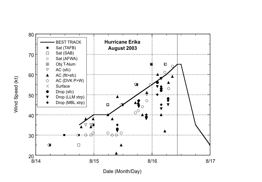
Figure 2:
Selected wind
observations and best track maximum sustained
surface wind speed curve for Hurricane Erika, 14-17 August 2003.
Aircraft observations have been adjusted for elevation using 90%,
80%, and 80% reduction factors for observations from 700 mb, 850
mb, and 1500 ft, respectively. Dropwindsonde observations include
actual 10 m winds (sfc), as well as surface estimates derived from
the mean wind over the lowest 150 m of the wind sounding (LLM), and
from the sounding boundary layer mean (MBL). The time of landfall is indicated by the solid vertical
line.
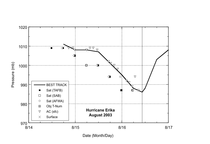
Figure 3:
Selected pressure
observations and best track minimum central
pressure curve for Hurricane Erika, 14-17 August 2003.The time of landfall is
indicated by the solid vertical line.
|


