Tropical Cyclone Report
Hurricane Claudette
8 - 17 July 2003
Jack Beven
National Hurricane Center
9 September 2003
Hurricane Claudette made landfall in Texas as a
Category 1 hurricane on the Saffir-Simpson Hurricane Scale and on
the northeastern Yucatan Peninsula of Mexico as a tropical storm.
It maintained tropical storm status for more than 24 hours after
landfall in Texas.
a. Synoptic History
Claudette formed from a tropical wave that moved
westward from the coast of Africa on 1 July. The wave first showed
signs of convective organization on 6 July. By 7 July satellite
imagery indicated sufficient organization to possibly classify the
system as a tropical depression near the Windward Islands. However,
the wave was moving westward at 20-25 kt at the time, and neither
surface observations nor an investigation flight by the Air Force
Reserve Hurricane Hunters indicated that the system had a closed
circulation. The aircraft did report flight-level winds of
tropical-storm force north of the vorticity maximum that passed
near Barbados and St. Lucia.
The wave continued rapidly westward with a further
increase in organization. Satellite intensity estimates suggested
the system was near tropical storm strength by 1500 UTC 8 July.
However, a second investigative flight could not find a closed
center at that time. Finally, near 1800 UTC the plane found a small
area of southwesterly winds and a pressure of 1006 mb. The wave
became Tropical Storm Claudette at that time. The "best track"
chart of the tropical cyclone's path is given in Figure 1, with the
wind and pressure histories shown in
Figure 2 and Figure 3, respectively.
The best track positions and intensities are listed in Table 1.
Claudette continued quickly westward through 9 July,
then it turned northwestward with some deceleration on the next
day. A continued northwestward motion brought Claudette to its
first landfall, on the northeastern Yucatan Peninsula of Mexico
near 1000 UTC 11 July.
During this period, Claudette underwent two notable
fluctuations in intensity. The first occurred around 0300-0400 UTC
9 July, when flight-level winds reported by an Air Force Reserve
Hurricane Hunter aircraft northeast of the center suggested that
Claudette might have reached hurricane strength. Subsequent data
shortly thereafter showed much lower winds, and it is estimated
that Claudette did not become a hurricane at that time.
A second noteworthy sequence of intensity changes
occurred on 10 July. An increase in convective organization and
strengthening began between 0000-0600 UTC. A Hurricane Hunter
flight near 1200 UTC reported a 10-n mi wide eye (also apparent in
visible and microwave satellite imagery), along with flight-level
winds, dropsonde winds, and pressures that indicated Claudette had
become a hurricane. The cyclone maintained hurricane intensity
through 1600 UTC. The central core then completely collapsed during
the next two hours. The aircraft could not fix the center at 1800
UTC due to the poor definition of both the wind field and the
convective pattern. While it is possible the aircraft did not
sample the maximum winds on the attempted 1800 UTC penetration,
rapid weakening was clearly underway.
Claudette then proceeded to become very disorganized.
The center became broad and poorly defined, and multiple low-level
centers were seen several times in satellite imagery between 1800
UTC 10 July and 0000 UTC 12 July. The convection was displaced well
to the north and east by southwesterly shear, with aircraft and
ship data indicating tropical storm-force winds in the convective
area. Much of the motion during this time may be due to reformation
of the center caused by convective bursts. The best track shows
45-50 kt winds during this period, but there is much greater than
normal uncertainty about both the winds and the central pressure
due to the disorganized nature of the storm.
The storm moved northwestward into the southern Gulf
of Mexico on 11 July. A north-northwestward jog occurred on 12 July
while Claudette became a little better organized. The storm
meandered erratically northwestward on 13 July, then turned
northward later that day. These track changes were likely due to a
combination of 1) weakening of a mid/upper-level ridge along the
northern Gulf coast caused by a developing trough over the eastern
United States, and 2) reformation of the center caused by strong
but asymmetric convection to the northeast. This change in motion
was accompanied by some decrease in the shear, and while the center
remained mostly exposed, Claudette slowly and unsteadily
strengthened on 13 July.
A building deep-layer ridge over the western United
States and the western Gulf coast states forced Claudette to
gradually turn west-northwestward late on 14 July. This brought the
storm to an area of lighter shear, which allowed an eyewall to form
and for Claudette to again become a hurricane at 0600 UTC 15 July.
A faster west-northwestward motion brought the center of Claudette
to the Texas coast at Matagorda Island (just east of Port O'Connor)
at 1530 UTC that day. Strengthening continued up to landfall, with
estimated maximum winds increasing to 80 kt and the central
pressure falling to 979 mb.
Claudette turned westward just after landfall and
weakened to a tropical storm at 0000 UTC 16 July. It then turned
west-northwestward again while moving into northern Mexico later
that day. This motion would continue until dissipation. Claudette
was slow to lose organization, as the radar and satellite
presentations of its structure remained distinct for more than 24
hr after landfall. Surface data indicates the system maintained
tropical storm strength until 0000 UTC 17 July. The low-level
circulation dissipated over the mountains of northwestern Mexico
later that day. However, the mid- and upper-level moisture and
vorticity continued west-northwestward, eventually crossing
southern California into the Pacific.
b. Meteorological Statistics
Observations in Claudette (Figure 2 and Figure 3)
include satellite-based Dvorak technique intensity estimates from the
Tropical Analysis and Forecast Branch (TAFB), the Satellite
Analysis Branch (SAB) and the U. S. Air Force Weather Agency
(AFWA), as well as flight-level and dropwindsonde observations from
flights of the 53rd Weather Reconnaissance Squadron of
the U. S. Air Force Reserve Command and the NOAA Aircraft
Operations Center. Surface data from ships and land stations are
included as well (Table 2 and Table 3).
Microwave data from the TRMM,
DMSP, and NOAA satellites, and data from the WSR-88D Doppler radars
in Houston, Corpus Christi, and Del Rio, Texas also played a
significant role in determining the best track of Claudette.
The Air Force Hurricane Hunters made 52 fixes during
Claudette's life, while the NOAA Hurricane Hunters made 4. The
maximum flight-level winds observed by the aircraft were 85 kt at
0334 UTC 9 July (1500 ft) and at 1517 UTC 15 July (700 mb) - the
latter as the eye of Claudette was crossing the Texas coast. Global
Positioning System (GPS) dropsondes deployed by the aircraft
reported surface winds of 73 kt at 1526 UTC 10 July and 70 kt at
1516 UTC 15 July. The latter dropsonde recorded a 96 kt wind at the
976 mb level.
At the time of the first occurrence of 85 kt winds on
9 July, the aircraft reported a central pressure of 1001 mb. Two
hours later, a pass through the same part of the storm at 850 mb
showed winds of only 56 kt. Based on this, it is estimated that
Claudette remained a tropical storm and the best track will show 60
kt at 0600 UTC 9 July. However, there is greater than normal
uncertainty about the value.
The 73-kt dropsonde surface winds on 10 July occurred
during Claudette's short-lived intensification into a hurricane
over the northwestern Caribbean. The aircraft reported a minimum
pressure of 988 mb at 1201 UTC, then reported 76-kt flight-level
winds at 700 mb at 1526 UTC. During the aborted attempt to fix the
center two hours later, the maximum 700- mb winds were only 51 kt.
The aircraft reported a minimum pressure of 1005 mb at the time,
but this was likely not at the center and the actual central
pressure is speculative. However, the weather officer on the
aircraft reported that the pressure near the center was about 10 mb
higher that 2 h earlier.
Aircraft and surface data indicate hurricane
conditions occurred over portions of the middle Texas coast. The
maximum sustained winds reported by an official observing site was
a 10-min average of 65 kt at the Remote Automated Weather Stations
(RAWS) site on Matagorda Island, Texas (Table 3). The Texas Coastal
Ocean Observation Network (TCOON) station at Port O'Connor reported
a 6-min average sustained wind 62 kt with a gust to 78 kt in the
western eyewall. Victoria, Texas, reported 54-kt sustained winds
with a gust to 72 kt, although that data is incomplete due to a
power failure. Tropical storm conditions occurred along much of the
middle and upper Texas coast and extended well inland across
southern Texas. Cotulla, Texas, reported sustained winds of 36 kt
with a gust to 46 kt at 0246 UTC 16 July, while Del Rio, Texas,
reported a gust to 47 kt.
Tropical-storm force winds also occurred well inland
over portions of southwestern Texas, including 38-kt sustained
winds with a gust to 50 kt at the Terrell County airport at 1658
UTC 16 July. While this station is at an elevation of 2300 ft,
there is no evidence that mountainous terrain enhanced the winds,
and this report is the basis for keeping Claudette a tropical storm
through 1800 UTC 16 July. Other reports of tropical storm wind
gusts occurred at Mt. Locke in the Davis Mountains, and at
Guadalupe Pass and The Bowl in the Guadalupe Mountains. These winds
were likely enhanced by mountainous terrain.
Tropical storm conditions likely occurred over
portions of the northeastern Yucatan Peninsula, but there were no
reports of tropical-storm winds from that area. Winds gusted to
tropical-storm force at Montego Bay, Jamaica. Winds also gusted to
tropical-storm force on St. Lucia during the passage of the
pre-Claudette tropical wave.
Many unofficial observations were received from the
landfall area, with a selection included in Table 3.
A storm chaser
(Tony Whitener) in Port O'Connor reported 83-kt sustained winds
with a gust to 93 kt measured at the top of a vehicle with good
exposure. While this observation is included in Table 3, it is
notable that the winds are 15-20 kt higher than the nearby TCOON
station and thus appear unrepresentative. A report from Seadrift
indicated 84-kt sustained winds with a gust to 96 kt. However, an
inspection of the site by National Weather Service (NWS) personnel
showed that the anemometer placement may have caused funneling of
the winds across the instrument. Thus, the report is not included
in Table 3.
The 84-kt and 83-kt unofficial observations suggest
the possibility that Claudette strengthened to a Category 2
hurricane as it was making landfall. This was not supported by the
aircraft data, which suggest maximum sustained winds of 75-80 kt as
the eye crossed the coast. Data from the NWS WSR-88D Doppler radars
indicated winds of 95-105 kt between 5,000-10,000 ft in the
northwest eyewall after Claudette made landfall. It is uncertain
how to convert these winds to sustained surface winds over land.
However, reduction factors derived from GPS dropsonde data
over water suggest 85-90 kt sustained
surface winds. A further reduction for land friction would reduce
the radar winds to at or below the 75-80 kt range suggested by the
aircraft data.
Damage surveys were conducted by the staffs of NWS
forecast offices in Corpus Christi and Houston in order to help
define the surface winds at landfall. These surveys concluded the
damage was consistent with Category 1 sustained winds. Unpublished
information from a damage survey by a wind engineering expert with
the commercial engineering firm Haag Engineering supports this
determination.
Based on the surveys, the data, and uncertainties (i.e.,
the possibility that the aircraft did not sample the strongest
winds), the landfall intensity of Claudette is estimated to be 80
kt - at the high end of Category 1 on the Saffir-Simpson Hurricane
Scale.
Several ships encountered Claudette during its life
(Table 2). The most significant observations included: 1) the
Explorer of the Seas, which reported 49-kt
sustained winds in the Yucatan Channel at 0356 UTC 11 July; 2) the
Rhapsody of the Seas, which reported 56-kt
sustained winds at 0600 UTC 14 July; 3) the James
N. Sullivan, which reported 55 kt winds at 1500 UTC 14 July;
and 4) the Galveston Bay, which reported
54-kt sustained winds at 2100 UTC 14 July. Several oil rigs in the
northwestern Gulf of Mexico reported hurricane-force winds 100-200
ft above the surface (Table 3). Not included in Table 3 is a wind
gust of 119 kt reported at the rig C337 which appears
unrealistic.
The lowest pressure reported by reconnaissance
aircraft was 979 mb just before landfall at 1414 UTC 15 July. The
lowest observed pressure on land was 980.0 mb observed by the Port
O'Connor storm chaser when the eye passed over.
Storm-surge flooding of 3-6 ft above normal tide
levels occurred near where the eye of Claudette made landfall.
Storm tides (storm surge plus astronomical tide) of 6-9 ft were
measured in the Galveston-Freeport area (Table 3). Tides were 1-2
ft above normal as far north as the southwestern Louisiana coast
and as far south as the Baffin Bay, Texas area.
Claudette moved quickly westward after landfall,
which limited rainfall totals. The highest storm-total rainfall was
6.5 in four miles south-southeast of Tilden, Texas
(Table 3a), and
there are other reports of 3-6 in amounts along the storm track.
NWS WSR-88D radar data estimates that as much as 8 in may have
fallen in some areas. These rains caused minor flooding in southern
Texas and some flash flooding in southwestern Texas. Rainfalls of
1-3 in also occurred over portions of the Yucatan Peninsula and the
Cayman Islands, with 3.22 in reported in Cancun.
Two tornadoes were reported during Claudette. One was
an F1 that damaged several buildings in Palacios, Texas. The other
touched down in Port Lavaca, Texas, causing damage to some
homes.
c. Casualty and Damage Statistics
Claudette is responsible for one direct and two
indirect deaths. The direct death was a 13-year old boy crushed by
a falling tree in Jourdanton, Texas. The first indirect death was a
33-year old woman who was hit by a falling limb after the storm was
over. The second indirect death was at Navarre Beach, Florida when
a 71-yr old man died after being pulled from surf generated by
Claudette. Press reports suggest the man suffered a heart attack
while swimming.
The American Insurance Services Group reported that
Claudette caused $90 million in damage to insured property in the
United States. The total damage estimate is twice this or $180
million. The damage includes five stations of the TCOON and Texas
Automated Buoy System (TABS) networks destroyed by the hurricane.
No significant damage was reported from Mexico, the Cayman Islands,
or Jamaica. Minor damage was reported in St. Lucia from the
pre-Claudette tropical wave.
d. Forecast and Warning Critique
The track forecast errors for Claudette were
generally small compared to normal. Average official track errors
(with the number of cases in parentheses) were 36 (30), 57 (30), 89
(28), 117 (26), 140 (22), 154 (18), and 154 (14) n mi for the 12,
24, 36, 48, 72, 96, and 120 h forecasts,
respectively1.
These errors are much lower than the average official
track errors for the 10-yr period
1993-20022
(45, 81, 116, 150, 225, 282, and 374 n mi, respectively)
(Table 4). These errors are also much lower than those of the
Climatology-Persistence methods, indicating the track forecasts had
considerable skill. The track forecast philosophy was quite good
overall. From Claudette's beginnings, the storm was forecast to
move westward to the western Caribbean, northwestward into the Gulf
of Mexico, and then westward toward the western Gulf coast.
However, the extent of the northward motion over the Gulf was not
fully anticipated, nor was the westward acceleration as Claudette
approached the western Gulf coast.
The intensity forecast errors for Claudette were also
well below the long-term means. Average official intensity errors
were 5, 7, 7, 9, 9, 8, and 8 kt for the 12, 24, 36, 48, 72, 96, and
120 h forecasts, respectively. For comparison, the average official
intensity errors over the 10-yr period 1993-2002 are 6, 10, 13, 15,
19, 21 , and 22 kt, respectively. The intensity forecast errors
were lower than those of the Statistical Hurricane Intensity
Forecast System (8, 11, 14, 17, 22, 19, and 16 kt for the 12, 24,
36, 48, 72, 96, and 120 h forecasts, respectively), indicating that
the intensity forecasts had considerable skill. The intensity
forecasts were generally correct in anticipating that southwesterly
vertical shear would slow development until Claudette was near the
western Gulf coast. However, significant overforecasts occurred
when Claudette briefly reached hurricane intensity on 10 July, as
the intensity forecasts at the time incorrectly called for
continued strengthening. Additionally, the amount of
intensification near the Texas coast was underforecast by 5-10
kt.
Table 5 lists the watches and warnings associated
with Claudette. Hurricane warnings for the Texas coast were issued
about 24 h before the center made landfall. A hurricane watch was
issued for the area from Port O'Connor southward about 48 h before
Claudette made landfall, while a hurricane watch was issued for the
remainder of the landfall area about 30 h before the center made
landfall. The first tropical storm warnings for the northeastern
Yucatan Peninsula were issued 37 h before the center made landfall.
Hurricane warnings issued on 10 July for the Yucatan Peninsula
proved unnecessary, because Claudette weakened rapidly after being
a hurricane for a few hours.
1
All forecast verifications in this report include the depression stage of the
cyclone. National Hurricane Center verifications presented in these reports
prior to 2003 did not include the depression stage.
2
Errors given for the 96 and 120 h periods are averages over the two-year
period 2001-2002.
Acknowledgements
Much of the data from the affected area was provided
by the NWS Weather Forecast Offices at Houston, Corpus Christi, San
Antonio, and Midland, Texas, and Lake Charles, Louisiana. NOS data
were provided by the NOAA National Ocean Service. RAWS data were
provided by the National Interagency Fire Center. TCOON data were
provided by the Division of Nearshore Research at Texas A&M
University-Corpus Christi. TABS data were provided by the
Geochemical and Environmental Research Group of Texas A&M
University. Other data were provided by the NOAA Forecast Systems
Laboratory and the Weather Underground web site. Data from Mexico,
the Cayman Islands, and Jamaica were provided by the meteorological
services of those countries.
Table 1: Best track
for Hurricane Claudette, 8-17 July 2003.
Date/Time
(UTC) | Position | Pressure
(mb) | Wind Speed
(kt) | Stage |
Lat.
(°N) | Lon.
(°W) |
| 07 / 0000 | 11.1 | 53.5 | 1010 | 25 | tropical wave |
| 07 / 0600 | 11.8 | 55.3 | 1010 | 30 | " |
| 07 / 1200 | 12.6 | 57.5 | 1010 | 30 | " |
| 07 / 1800 | 13.2 | 59.8 | 1010 | 35 | " |
| 08 / 0000 | 13.7 | 62.0 | 1009 | 35 | " |
| 08 / 0600 | 14.0 | 64.8 | 1009 | 40 | " |
| 08 / 1200 | 14.4 | 67.6 | 1009 | 40 | " |
| 08 / 1800 | 14.8 | 70.0 | 1006 | 45 | tropical
storm |
| 09 / 0000 | 15.0 | 72.0 | 1001 | 50 | " |
| 09 / 0600 | 15.1 | 74.4 | 1003 | 60 | " |
| 09 / 1200 | 15.3 | 76.5 | 1004 | 55 | " |
| 09 / 1800 | 15.8 | 78.6 | 1002 | 55 | " |
| 10 / 0000 | 16.1 | 80.3 | 1002 | 55 | " |
| 10 / 0600 | 16.6 | 81.7 | 998 | 55 | " |
| 10 / 1200 | 17.5 | 82.8 | 988 | 70 | hurricane |
| 10 / 1800 | 18.6 | 84.1 | 1003 | 55 | tropical
storm |
| 11 / 0000 | 19.7 | 85.5 | 1010 | 50 | " |
| 11 / 0600 | 20.4 | 86.3 | 1009 | 50 | " |
| 11 / 1200 | 21.1 | 87.2 | 1009 | 50 | " |
| 11 / 1800 | 21.8 | 88.2 | 1009 | 45 | " |
| 12 / 0000 | 22.6 | 89.2 | 1008 | 45 | " |
| 12 / 0600 | 23.3 | 90.2 | 1007 | 45 | " |
| 12 / 1200 | 23.9 | 90.7 | 1006 | 45 | " |
| 12 / 1800 | 24.6 | 90.9 | 1008 | 45 | " |
| 13 / 0000 | 24.9 | 91.5 | 1003 | 45 | " |
| 13 / 0600 | 24.9 | 91.9 | 1005 | 45 | " |
| 13 / 1200 | 25.1 | 92.1 | 999 | 50 | " |
| 13 / 1800 | 25.3 | 92.2 | 995 | 50 | " |
| 14 / 0000 | 25.6 | 92.2 | 991 | 55 | " |
| 14 / 0600 | 26.0 | 92.3 | 993 | 55 | " |
| 14 / 1200 | 26.7 | 92.6 | 991 | 55 | " |
| 14 / 1800 | 27.3 | 93.0 | 989 | 60 | " |
| 15 / 0000 | 27.7 | 93.6 | 988 | 60 | " |
| 15 / 0600 | 27.9 | 94.6 | 987 | 65 | hurricane |
| 15 / 1200 | 28.3 | 95.5 | 982 | 75 | " |
| 15 / 1800 | 28.6 | 96.9 | 984 | 70 | " |
| 16 / 0000 | 28.5 | 98.2 | 995 | 50 | tropical
storm |
| 16 / 0600 | 28.5 | 99.4 | 999 | 40 | " |
| 16 / 1200 | 28.8 | 100.8 | 1003 | 35 | " |
| 16 / 1800 | 29.3 | 102.6 | 1007 | 35 | " |
| 17 / 0000 | 29.9 | 104.3 | 1014 | 30 | tropical
depression |
| 17 / 0600 | 30.5 | 106.0 | 1016 | 25 | remnant low |
| 17 / 1200 | 30.9 | 107.7 | 1016 | 25 | " |
| 17 / 1800 | | | | | dissipated |
| 15 / 1530 | 28.3 | 96.2 | 979 | 80 | minimum pressure |
| 11 / 1000 | 20.8 | 86.9 | 1009 | 50 | landfall at Puerto Morelos, Mexico |
| 15/ 1530 | 28.3 | 96.2 | 979 | 80 | landfall at Matagorda Island, Texas |
Table 2: Selected
ship reports with winds of at least 34 kt for Hurricane Claudette,
8-17 July 2003.
| Ship Name or Call Sign | Date/Time (UTC) | Lat.
(°N) | Lon.
(°W) | Wind dir/speed (deg/kt) | Pressure (mb) |
| R. Hal Dean | 09 / 0300 | 16.9 | 72.3 | 090 / 40 | 1014.5 |
| R. Hal Dean | 09 / 0600 | 16.6 | 72.0 | 090 / 36 | 1012.0 |
| Explorer of the Seas | 11 / 0356 | 21.2 | 86.2 | 080 / 50 | 1009.6 |
| Saudi Abha | 11 / 2100 | 26.1 | 87.6 | 120 / 35 | 1017.2 |
| C6FM7 | 13 / 2100 | 25.6 | 89.6 | 060 / 41 | 1014.0 |
| Discoverer Spirit | 14 / 0000 | 27.3 | 91.1 | 095 / 55 gust 67 | N / A |
| Cleveland | 14 / 0600 | 26.6 | 90.8 | 090 / 37 | 1009.0 |
| Rhapsody of the Seas | 14 / 0600 | 28.1 | 92.8 | 050 / 56 | 1010.0 |
| Rhapsody of the Seas | 14 / 0900 | 27.6 | 92.0 | 010 / 53 | 1006.0 |
| Ocean Valiant | 14 / 1100 | 27.3 | 92.0 | 180 / 40 gust 53 | N / A |
| Sargasso | 14 / 1200 | 27.1 | 90.8 | 150 / 44 | 1010.6 |
| Cleveland | 14 / 1200 | 27.9 | 92.6 | 090 / 37 | 1008.0 |
| Sargasso | 14 / 1500 | 27.0 | 90.5 | 150 / 44 | 1013.0 |
| James N.
Sullivan | 14 / 1500 | 27.6 | 92.8 | 080 / 55 | 1003.7 |
| Discoverer
Deep Seas | 14 / 1800 | 27.2 | 90.8 | 140 / 40 | 1012.8 |
| Overseas New
Orleans | 14 / 1800 | 28.1 | 91.2 | 120 / 38 | 1012.0 |
| James N.
Sullivan | 14 / 2100 | 27.5 | 92.6 | 150 / 50 | 999.7 |
| Galveston Bay | 14 / 2100 | 28.3 | 93.1 | 080 / 54 | 1005.0 |
| Celebration | 15 / 1200 | 26.4 | 94.0 | 200 / 35 | 1008.0 |
|
Table 3: Selected surface observations for Hurricane
Claudette 8-17 July 2003.
| | Minimum
Sea-level
Pressure | Maximum Surface Wind Speed
(kt) | |
| Location | Date/
Time
(UTC) | Press.
(mb) | Date/
Timea
(UTC) | Sust.
Windb
(kts) | Peak
Gust (kts) | Storm
Surgec
(ft) | Storm
Tided
(ft) | Rain
(storm total)
(in) |
| Texas |
| Alice (KALI) | 15/2242 | 1003.3 | 15/21033 | | 35 | | | 0.36 |
| Angleton (KLBX) | 15/1253 | 1005.6 | 15/1331 | | 43 | | | 2.60 |
| Aransas
RAWS | | | 15/1857 | | 64 | | | 4.67 |
| Bay City
(KBYY) | 15/1448 | 1002.1 | 15/1528 | 36 | 50 | | | 1.67 |
| Clear Lake TCOON | | | | | | | 5.63 | |
| Copano Bay TCOON | | | | | | | 2.43 | |
| Colorado River Bypass USGS | | | | | | | 5.56 | |
| Corpus Christi Airport (KCRP) | 15/2031 | 1004.2 | 15/2018 | | 34 | | | 0.38 |
| Corpus Christi NAS (KNGP) | | | 15/2141 | | 36 | | | 0.65 |
| Corpus Christi Bob Hall Pier NOS | | | 16/0800 | | 44 | 2.75 | | |
| Cotulla
(KCOT) | 16/0146 | 997.9 | 16/0246 | 36 | 46 | | | 1.81 |
| Del Rio (KDRT) | | | 16/1253 | 31 | 47 | | | |
| Eagle Point NOS | 15/0924 | 1008.8 | 15/1124 | 38 | 46 | 4.22 | | |
| East Matagorda Bay TCOONe | | | 15/1500 | 51 | 71 | | | |
| Freeport
NOS | | | | | | 5.14 | | |
| Freeport TCOON | | | 15/1354 | 40 | 56 | | | |
| Freeport USGS | | | 15/1200 | | 44 | | 9.15 | |
| Galveston Bay/Moses Lake USGS | | | | | | | 4.90 | |
| Galveston Airport (KGLS) | 15/1052 | 1008.7 | 15/1253 | 38 | 47 | | | 2.01 |
| Galveston North Jetty NOS | 15/1224 | 1007.6 | 15/0830 | 40 | 54 | 4.00 | | |
| Galveston Pier 21 NOS | 15/1224 | 1008.6 | | | | 3.71 | | |
| Galveston Pleasure Pier NOS | 15/1030 | 1007.3 | 15/1048 | 42 | 54 | 5.28 | | |
| Galveston South Jetty TCOONe | | | 15/0600 | 35 | 52 | | 8.74 | |
| George West RAWS | | | 15/2218 | | 55 | | | 2.86 |
| Guadalupe Pass (KGDP) | | | 17/0451 | 38 | 45 | | | |
| Highland Bayou Diversion Channel USGS | | | | | | | 6.15 | |
| Highland Bayou/Hitchcock USGS | | | | | | | 5.77 | |
| Hondo (KHDO) | 16/0151 | 1008.4 | 16/0625 | | 44 | | | |
| Houston Clover Field (KLVJ) | 15/0853 | 1010.0 | 15/0942 | | 34 | | | |
| Houston Hobby Airport (KHOU) | 15/1153 | 1010.6 | 15/1104 | | 35 | | | 1.10 |
| Houston Port
USGS | | | | | | | 7.40 | |
| Ingleside TCOONe | | | 15/1900 | | 39 | | 2.54 | |
| Jamaica Beach NWS COOP | 15/1215 | 1008.0 | 15/0744 | 36 | 48 | | 5.70 | 2.49 |
| Kemah USGS | | | 15/1200 | | 35 | | 5.94 | |
| LaMarque USGS | | | | | | | 5.00 | |
| Marfa (KMRF) | | | 16/2115 | | 36 | | | |
| Matagorda Colorado River Locks* | | | | | | | 8.00 | |
| Matagorda
RAWS | | | 15/1800 | 65 | | | | |
| McMullen Cnty | | | 16/0218 | | 53 | | | |
| Mesquite Point TCOONe | | | 15/1000 | 31 | 38 | | 3.74 | |
| Morgans Point NOS | 15/1118 | 1009.8 | 15/1148 | 39 | 46 | 4.96 | | |
| Mt. Locke | | | 16/1820 | | 46 | | | |
| NWS Station 1 TCOON | 15/1642 | 1002.7 | 15/1912 | | 47 | | | |
| Orange
Grove | | | 15/2245 | | 35 | | | |
| Palaciose (KPSX) | 15/1153 | 1003.1 | 15/1153 | | 35 | | | |
| Pearland (KLVJ) | 15/1053 | 1010.0 | 15/1039 | | 34 | | | 1.66 |
| Port Aransas TCOONe | | | 15/1748 | | 37 | | 3.40 | |
| Port O'Connor TCOON | | | 15/1506 | 62 | 78 | | 6.13 | |
| Rockport (KRKP) | 15/1800 | 999.7 | 15/1800 | | 36 | | | 2.01 |
| Rockport NOS | | | | | | 1.83 | | |
| Rollover Pass TCOON | | | | | | | 3.69 | |
| Round Point TCOONe | 15/1100 | 1009.8 | 15/1200 | | 40 | | 5.25 | |
| S. Bird Island TCOONe | | | 16/0800 | | 35 | | | |
| Sabine Pass North NOS | | | | | | 2.55 | | |
| San Antonio Stinson Arpt (KSSF) | | | 16/0053 | | 42 | | | |
| San Bernard RAWS | | | 15/1200 | 35 | | | | 2.65 |
| Seadrift
TCOONe | | | 15/1600 | 41 | 53 | | 3.66 | |
| Terrell County Arpt (K6R6) | | | 16/1658 | 38 | 50 | | | |
| The Bowl | | | 17/0604 | | 61 | | | |
| Victoriae (KVCT) | 15/1800 | 994.9 | 15/1818 | 54 | 72 | | | |
| Victoria RAWS | | | 15/1830 | 53 | 71 | | | |
| West Galveston Bay TCOON | 15/1100 | 1004.4 | 15/0848 | 41 | 58 | | 5.23 | |
| White Point
TCOON | | | 15/2006 | | 38 | | 2.23 | |
| Louisiana |
| Cameron USGSe | | | 15/1000 | | 37 | | 2.98 | |
| Jamaica |
| Montego Bay | | | 09/1622 | | 40 | | | |
| Buoy/C-MAN |
| NOAA Buoy 42001 | 14/0800 | 1011.4 | 12/1710 | 36g | 50 | | | |
| NOAA Buoy 42019 | 15/1100 | 990.3 | 15/0810 | 47g | 60 | | | |
| NOAA Buoy 42035 | 15/0900 | 1008.0 | 15/0700 | 37 | 49 | | | |
| NOAA Buoy 42041 | | | 14/1117 | | 39 | | | |
| Port Aransas C-MAN (PTAT2) | 15/2000 | 1003.8 | 15/1930 | 33g | 44 | | | |
| Sea Rim State Park C-MAN (SRST1) | 15/1000 | 1010.7 | 15/1000 | 45 | 54 | | | |
| TABS Buoy Nf | 14/2009 | 1007.9 | 14/2039 | | 56 | | | |
| TABS Buoy Vf | 14/1709 | 1010.6 | 14/1609 | | 46 | | | |
| Oil Rigsh |
| East Cameron 312 | | | 14/1830 | 65 | | | | |
| East Cameron 377 | | | 14/1830 | 74 | | | | |
| ENSCO 7500 | | | 14/0600 | 39 | | | | |
| Eugene Island 322A | | | 14/1100 | 65 | 83 | | | |
| Garden Banks 128 | | | 14/1545 | 65 | 80 | | | |
| Garden Banks 298 | | | 14/1830 | 80 | | | | |
| Garden Banks 426 | | | 14/1300 | 68 | 74 | | | |
| Garden Banks 657 | | | 14/2000 | 40 | 48 | | | |
| Green Canyon 158 | | | 14/1203 | 36 | | | | |
| KW60 | | | 14/1700 | 40 | 44 | | | |
| Texas Unofficial Reports |
| Bloomington Dow Chemical | | | 15/1650 | 60 | | | | |
| Brazos TXDOT | | | 15/1430 | 38 | | | | |
| Clear Creek TXDOT | | | 15/1400 | 35 | | | | |
| Clear Creek at Seabrook | | | | | | | 5.67 | |
| Fort Davis Weather Underground | | | 15/2208 | | 37 | | | |
| Galveston Causeway TXDOT | | | 15/1100 | 37 | | | | |
| Hartman TXDOT | | | 15/1200 | 34 | | | | |
| Kemah TXDOT | | | 15/0830 | 47 | | | | |
| Long Mott Dow Chemical | | | 15/1827 | 68 | 83 | | | |
| Point Comfort Formosa Plastics | | | 15/1545 | 70 | 87 | | | |
| Port Lavaca Co-op | | | 15/1800 | | 63 | | | |
| Port O'Connor (Whitener) | 15/ N/A | 980.0 | 15/ N/A | 83 | 93 | | | |
| Rawlings Bait Camp | | | | | | | 3.40 | |
| Schroeder Skinner Ranch Weather Underground | 15/1900 | 993.1 | 15/1900 | 37 | 57 | | | 3.20 |
| Tivoli Co-op | | | 15/ N/A | | 57 | | | |
| Victoria (Sudduth) | | | 15/ N/A | 54 | 65 | | | |
| Wadsworth South Texas Nuclear Plant | | | 15/1400 | 44 | 73 | | | |
*Colorado
River Locks at Matagorda reading was taken from a high water mark
in a boat house referenced to mean lower low water
(MLLW)
aDate/time is for sustained wind when both
sustained and gust are listed.
bExcept
as noted, sustained wind averaging periods for C-MAN and land-based
ASOS reports are 2 min; buoy averaging periods are 8 min; NOS and
TCOON stations averaging periods are 6 min; RAWS stations report 10
min average sustained winds.
cStorm
surge is water height above normal astronomical tide
level.
dStorm
tide from TCOON stations is water height above MLLW. For other
stations it is water height above National Geodetic Vertical Datum
(1929 mean sea level) unless noted.
eIncomplete record - more extreme values may have
occurred
f Station destroyed -
more extreme values may have occurred
g10-min average
hOil rig anemometer
heights are generally 100-200 ft; wind averaging periods are
unknown |
Table 3a: Selected
storm rainfalls for Texas from Hurricane Claudette, 8-17 July
2003.
| Station | Storm-total Rainfall (in) |
| Texas |
| Big Wells 2W | 3.20 |
| Campbellton 3NE | 4.50 |
| Charlotte 5NNW | 3.10 |
| Derby - Frio
River | 3.10 |
| Dilly | 4.89 |
| Edna | 3.48 |
| Falls City 7WSW | 3.10 |
| Floresville | 3.05 |
| Fowlerton | 3.48 |
| Galveston CG | 3.70 |
| Goliad 1SE | 3.01 |
Table 4:
Preliminary forecast evaluation (heterogeneous sample) for
Hurricane Claudette, 8-17 July 2003.
Forecast errors (n mi) are followed by
the number of forecasts in parentheses. Errors smaller than the NHC
official forecast are shown in bold-face type.
Verification includes the depression stage.
| Forecast Technique | Period (hours) |
| 12 | 24 | 36 | 48 | 72 | 96 | 120 |
| CLP5 | 43 (29) | 89 (29) | 145 (27) | 191 (25) | 262 (21) | 334 (17) | 381 (14) |
| A90E | 40 (21) | 77 (21) | 135 (19) | 174 (17) | 221 (13) | 220 (8) | 368 (8) |
| A98E | 43 (27) | 79 (27) | 127 (25) | 159 (23) | 208 (19) | 245 (15) | 347 (14) |
| A9UK | 36 (14) | 67 (14) | 107 (13) | 142 (12) | 227 (10) | | |
| LBAR | 40 (27) | 65 (27) | 99 (25) | 124 (23) | 119
(19) | 138
(15) | 251 (14) |
| BAMS | 44 (27) | 77 (27) | 110 (25) | 142 (23) | 235 (19) | 356 (15) | 443 (14) |
| BAMM | 37 (27) | 61 (27) | 82
(25) | 96
(23) | 145 (19) | 217 (15) | 292 (14) |
| BAMD | 43 (27) | 73 (27) | 104 (25) | 118 (23) | 146 (19) | 209 (15) | 335 (14) |
| COAI | 25
(4) | 42
(4) | 99 (4) | 177 (4) | | | |
| COAL* | 30
(5) | 49
(5) | 63 (2) | 116 (2) | | | |
| COEI | 40 (22) | 77 (22) | 125 (20) | 167 (19) | | | |
| COCE* | 39 (14) | 72 (14) | 101 (14) | 142 (13) | | | |
| AF1I | 80 (23) | 168 (23) | 270 (23) | 358 (21) | 499 (19) | | |
| AFW1* | 100 (13) | 172 (13) | 276 (12) | 385 (11) | 532 (10) | | |
| GFNI | 41 (26) | 75 (26) | 115 (24) | 152 (22) | 220 (18) | | |
| GFDN* | 40 (14) | 67 (14) | 106 (13) | 146 (12) | 213 (10) | | |
| GFDI | 32
(25) | 56
(25) | 86
(23) | 119 (20) | 163 (15) | 226 (9) | 273 (8) |
| GFDL* | 43 (26) | 64 (25) | 87
(22) | 122 (19) | 160 (15) | 191 (10) | 289 (8) |
| UKMI | 33
(26) | 56
(26) | 81
(24) | 93
(21) | 120
(18) | 171 (14) | 295 (10) |
| UKM* | 42 (14) | 59 (14) | 79
(14) | 88
(13) | 93
(11) | 163 (9) | 262 (7) |
| NGPI | 36 (29) | 60 (29) | 89 (27) | 112
(25) | 127
(21) | 143
(14) | 203 (12) |
| NGPS* | 40 (29) | 60 (29) | 83
(28) | 114
(26) | 133
(22) | 124
(14) | 175 (12) |
| AVNI | 38 (27) | 65 (27) | 92 (25) | 120 (23) | 188 (19) | 249 (15) | 299 (11) |
| AVNO* | 43 (26) | 66 (26) | 93 (25) | 122 (23) | 180 (20) | 229 (13) | 275 (10) |
| AEMI | 37 (18) | 70 (18) | 85
(16) | 92
(15) | 133
(13) | | |
| AEMN* | 58 (12) | 80 (12) | 103 (12) | 119 (11) | 133
(9) | | |
| GUNS | 29
(23) | 48
(23) | 73
(21) | 88
(17) | 110
(13) | 136
(7) | 177 (6) |
| GUNA | 29
(23) | 50
(23) | 73
(21) | 92
(17) | 122
(13) | 147
(7) | 191 (6) |
| FSSE | 34
(13) | 59 (13) | 82
(13) | 103
(12) | 135
(9) | | |
| OFCI | 36 (29) | 62 (29) | 93 (27) | 118 (25) | 147 (21) | 156 (17) | 155 (13) |
| OFCL | 36 (30) | 57 (30) | 89 (28) | 117 (26) | 140 (22) | 154 (18) | 154 (14) |
| NHC Official (1993-2002 mean) | 45 (2985) | 81 (2726) | 116 (2481) | 150 (2230) | 225 (1819) | 282 (265) | 374 (216) |
*Output from these models was unavailable at time
forecast issued. |
Table 5: Watch and
warning summary for Hurricane Claudette, 8-17 July
2003.
| Date/Time | Action | Location |
| 8 / 2100 | Tropical Storm Watch
issued | Cayman
Islands |
| 8 / 2100 | Tropical Storm Warning
issued | Jamaica |
| 9 / 0300 | Tropical Storm Warning
issued | Grand Cayman |
| 9 / 1500 | Hurricane Watch
issued | Chetumal to Cabo Catoche,
Mexico |
| 9 / 2100 | Tropical Storm Warning
issued | Chetumal to Cabo Catoche,
Mexico |
| 10 / 0000 | Tropical Storm Warning
discontinued | Jamaica |
| 10 / 1500 | Hurricane Warning
issued | Chetumal to Cabo Catoche,
Mexico |
| 10 / 1500 | Tropical Storm Warning
extended westward | Cabo Catoche to Campeche,
Mexico |
| 10 / 1500 | Tropical Storm Warning
issued | Belize City to Belize/Mexico
Border |
| 10 / 2100 | Tropical Storm Warning
extended westward | Progreso to Campeche,
Mexico |
| 10 / 2100 | Hurricane Warning changed to
Tropical Storm Warning | Chetumal to Progreso,
Mexico |
| 11 / 0300 | All coastal watches/warnings
discontinued | Cayman
Islands |
| 11 / 0300 | Hurricane Warning changed to
Tropical Storm Warning | Chetumal to Campeche,
Mexico |
| 11 / 0300 | Tropical Storm Warning
discontinued | Belize coast |
| 11 / 1500 | Tropical Storm Warning
discontinued | West of Progreso, Mexico and
south of Tulum, Mexico |
| 11 / 2100 | Tropical Storm Warning
discontinued | Mexican
coast |
| 13 / 1500 | Hurricane Watch
issued | Rio San Fernando to US/MX
border, Mexico, and Port O'Connor to Brownsville, Texas |
| 14 / 0900 | Tropical Storm Watch
issued | Matagorda to High Island,
Texas |
| 14 / 0900 | Hurricane Watch extended
northward | Port O'Connor to Matagorda,
Texas |
| 14 / 1500 | Hurricane Warning
issued | Baffin Bay to San Luis Pass,
Texas |
| 14 / 1500 | Tropical Storm Warning
issued | San Luis Pass, Texas to
Cameron, Louisiana |
| 14 / 1500 | Hurricane Watch
discontinued | Rio San Fernando to US/MX
border, Mexico |
| 14 / 2100 | Hurricane Warning extended
northward | San Luis Pass to High Island,
Texas |
| 14 / 2100 | Tropical Storm Warning
extended eastward | Cameron to Intracoastal City,
Louisiana |
| 14 / 2100 | Hurricane Warning
modified | Baffin Bay to High
Island |
| 15 / 1500 | Tropical Storm Warning
discontinued | Louisiana
coast |
| 15 / 1500 | Hurricane Watch
discontinued | Brownsville to Baffin Bay,
Texas |
| 15 / 2100 | Hurricane Warning changed to
Tropical Storm Warning | Port Aransas to Freeport,
Texas |
| 15 / 2100 | Tropical Storm Warning
discontinued | East of Freeport, Texas and
south of Port Aransas, Texas |
| 16 / 0300 | All coastal warnings
discontinued | Texas coast |
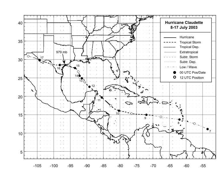
Figure 1:
Best track positions for
Hurricane Claudette, 8-17 July 2003.
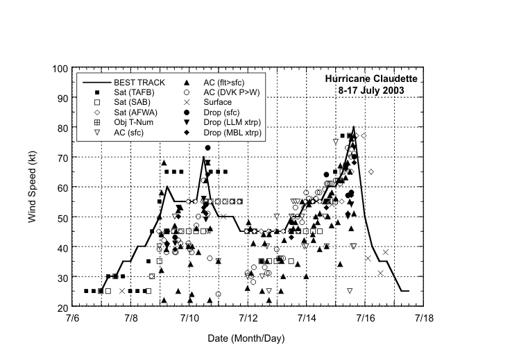
Figure 2:
Selected wind
observations and best track maximum sustained surface wind speed
curve for Hurricane Claudette, 8-17 July 2003. Aircraft
observations have been adjusted for elevation using 90%, 80%, and
80% reduction factors for observations from 700 mb, 850 mb, and
1500 ft, respectively. Dropwindsonde observations include actual 10
m winds (sfc), as well as surface estimates derived from the mean
wind over the lowest 150 m of the wind sounding (LLM), and from the
sounding boundary layer mean (MBL).
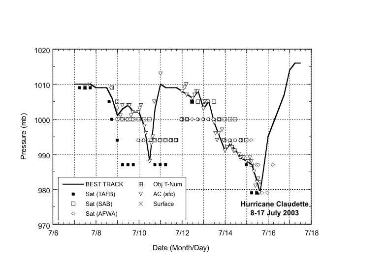
Figure 3:
Selected pressure
observations and best track minimum central pressure curve for
Hurricane Claudette, 8-17 July 2003.
|


