Tropical Cyclone Report
Tropical Storm Bill
29 June - 2 July 2003
Lixion A. Avila
National Hurricane Center
30 July 2003
Revised: 8 December 2003
Bill made landfall on the Louisiana coast just west of
Cocodrie as a 50-kt tropical storm.
a. Synoptic History
The interaction of a tropical wave with a mid- to
upper-level low resulted in the formation of a surface low pressure
area over the Yucatan Peninsula on 28 June. This system was
accompanied by a large area of cloudiness and thunderstorms that
extended eastward over the northwestern Caribbean Sea. Upper-level
winds were marginally favorable for development but the interaction
with land inhibited tropical cyclone formation. As soon as the low
moved toward the north-northwest away from Yucatan, the convection
became better organized. It is estimated that a tropical depression
formed at 0600 UTC 29 June and reached tropical storm status by
1200 UTC on the same day.
Bill moved on a north-northwesterly to northerly
track and, as the shear relaxed, the storm gradually intensified.
It then turned to the north-northeast and reached its peak
intensity of 50 knots, with a minimum pressure of 997 mb, at 1800
UTC 30 June when the cyclone's center was very near the coast.
Initially, the convection and stronger winds were located to the
northeast of the center due to wind shear from the southwest. Near
landfall time, the wind field and convection became a little more
symmetric as the shear relaxed. Bill made landfall near King Lake,
about 20 miles west of Cocodrie on the south coast of Louisiana at
its peak intensity around 1900 UTC 30 June. Thereafter, Bill
weakened to a tropical depression as it moved toward the northeast
over Central Mississippi and Alabama. It became an extratropical
low near the border of Tennessee and Virginia by 1800 UTC 2 July
and was absorbed by a frontal system by 0600 UTC 3 July.
The "best track" chart of the tropical cyclone's path is given in
Figure 2, with the wind and pressure histories shown in
Figure 3a and Figure 3b, respectively.
The best track positions and intensities are
listed in Table 1. To see radar and satellite loops at landfall
click on Figure 1a and Figure 1b below:

Figure 1a:
Radar loop for Tropical Storm Bill, 29 June - 2 July,
2003. (Note: large file 3.3MB)

Figure 1b:
Satellite loop for Tropical Storm Bill, 29 June- 2 July,
2003. (Note: large file 3.1MB)
b. Meteorological Statistics
Observations in Tropical Storm Bill (Figure 3a and Figure 3b)
include satellite-based Dvorak technique intensity estimates from the
Tropical Analysis and Forecast Branch (TAFB), the Satellite
Analysis Branch (SAB) and the U. S. Air Force Weather Agency
(AFWA), as well as flight-level observations from flights of the
53rd Weather Reconnaissance Squadron of the U.S. Air
Force Reserve Command. Ship reports of winds of tropical storm
force associated with Bill are given in Table 2, and selected
surface observations from land stations and data buoys are given in
Table 3.
Bill reached tropical storm status based on a report of 38 knots
from the ship HG3Q located to the northeast of the developing
center at 1200 UTC 29 June. Bill's peak intensity of 50 knots and
minimum pressure of 997 mb were based on a report from a
reconnaissance plane of 66 knots at 850 mb and a reliable minimum
pressure of 997 mb surface observation from Lumcon Marine Center,
near Cocodrie, respectively.
c. Casualty and Damage Statistics
There were four deaths associated with Bill. A
10-year old boy drowned in Holly Spring Creek in Raleigh, North
Carolina, a man was killed by a falling tree in Atlanta, Georgia,
and two swimmers drowned at Panama City Beach, Florida in rip
currents produced by Bill. The wind damage was confined to downed
branches and trees across the eastern portion of southeast
Louisiana and coastal Mississippi where there were power outages.
The most significant storm surge flooding was noted in coastal
sections of southeast Louisiana primarily in southern Terrebone
Parish where the local levee was breached and overtopped in the
Montegut area. This resulted in some homes being flooded. An F1
(Fujita Scale) tornado touched down in Reserve, Louisiana around
1710 UTC 30 June, hitting a private school and causing significant
damage to several buildings. It then hit a mobile home park
damaging at least 20 homes. The Property Claim Services Division of
the Insurance Service Office reports that insured losses due to
Bill totaled 22 million dollars in Louisiana.
Total losses for Louisiana and Mississippi are estimated at $50
million.
d. Forecast and Warning Critique
Advisories on the tropical cyclone were initiated
when early morning visible images confirmed the presence of a
well-defined center of circulation. Concurrently, a report from a
ship indicated that the winds had reached tropical storm
strength-hence there were no tropical depression advisories. This
transition can occur when a strong pressure gradient prevails
before a system in formative stage develops a closed circulation.
However, a post-analysis suggests that a tropical depression may
have formed six hours earlier, as indicated in the best track.
Bill was a short-lived tropical cyclone and the
number of forecasts is quite small. The average official track
errors were 54, 96,146 and 189 n mi for the 12, 24, 36, 48 h
forecasts, respectively1.
These errors are greater than the average official
track errors for the 10-yr period 1993-2002 of 45, 81, 116, 150 n
mi, respectively, Table 4 includes a summary of all track guidance
during Bill. Average official intensity errors were 4, 6, 3 and 1
kt for the 12, 24, 36, 48 h forecasts, respectively. For
comparison, the average official intensity errors over the 10-yr
period 1993-2002 are 6, 10, 13, and 15 kt, respectively.
Table 5 lists the watches and warnings associated
with Tropical Storm Bill.
The weather activity that became Tropical Storm Bill
was first described in the Tropical Weather Outlook issued at 1130
am EDT June 24, more than 6 days prior to landfall. After genesis,
the potential for intensification was stated in all the public and
forecast advisories. The tropical storm warning was issued 22 hours
prior to landfall. Although Bill made landfall within the area of
warning, it is always difficult to precisely forecast the point of
landfall. Figure 4 shows the track guidance available at 0600 UTC
30 June. Note that none of the models captured the
north-northeastward turn of Bill prior to landfall.
1All forecast verifications in this report include the
depression stage of the cyclone. National Hurricane Center verifications
presented in these reports prior to 2003 did not include the depression
stage.
Table 1: Best track for Tropical Storm Bill, 29 June-2 July 2003.
Date/Time
(UTC) | Position | Pressure
(mb) | Wind Speed
(kt) | Stage |
Lat.
(°N) | Lon.
(°W) |
| 28 / 0600 | 19.5 | 89.0 | 1009 | 20 |
low |
| 28 / 1200 | 20.0 | 89.3 | 1008 | 20 |
" |
| 28 / 1800 | 20.3 | 89.4 | 1008 | 20 |
" |
| 29 / 0000 | 21.0 | 89.8 | 1008 | 20 |
" |
| 29 / 0600 | 22.0 | 90.0 | 1007 | 30 | tropical depression |
| 29 / 1200 | 23.4 | 90.5 | 1007 | 35 | tropical
storm |
| 29 / 1800 | 24.6 | 91.1 | 1009 | 40 |
" |
| 30 / 0000 | 25.9 | 91.3 | 1008 | 45 |
" |
| 30 / 0600 | 27.1 | 91.5 | 1007 | 45 |
" |
| 30 / 1200 | 28.2 | 91.5 | 1002 | 50 |
" |
| 30 / 1800 | 29.1 | 91.0 | 997 | 50 |
" |
| 01 / 0000 | 30.4 | 90.3 | 998 | 45 |
" |
| 01 / 0600 | 31.6 | 89.3 | 1003 | 30 | tropical depression |
| 01 / 1200 | 32.7 | 88.4 | 1004 | 25 |
" |
| 01 / 1800 | 33.6 | 87.0 | 1007 | 20 |
" |
| 02 / 0000 | 34.1 | 86.0 | 1007 | 20 |
" |
| 02 / 0600 | 35.0 | 84.5 | 1007 | 20 |
" |
| 02 / 1200 | 35.6 | 83.5 | 1009 | 20 |
" |
| 02 / 1800 | 36.5 | 82.0 | 1009 | 20 |
extratropical |
| 03/ 0000 | 37.3 | 79.5 | 1009 | 20 |
" |
| 03/ 0600 | | | | | absorbed by a front |
| 30 / 1800 | 29.1 | 91.0 | 997 | 50 | minimum pressure |
| 30 / 1900 | 29.3 | 91.0 | 997 | 50 | landfall at King Lake, LA or 20 miles W of
Cocodrie, LA. |
Table 2: Selected ship reports with winds of at least 34 kt for Tropical
Storm Bill, 29 June-2 July 2003.
| Ship Name or Call Sign | Date/Time (UTC) | Lat.
(°N) | Lon.
(°W) | Wind dir/speed (deg/kt) | Pressure (mb) |
| H3GQ | 29 / 1200 | 24.2 | 88.9 | 150 / 38 | 1013.0 |
| C6FM7 | 29 / 1500 | 25.0 | 90.0 | 130 / 40 | 1014.0 |
| C6FM7 | 29 / 1800 | 25.4 | 89.7 | 140 / 40 | 1014.0 |
| H3GQ | 29 / 1800 | 25.6 | 90.3 | 130 / 35 | 1012.0 |
| BURL1 | 29 / 2000 | 28.9 | 89.4 | 180 / 36 | 1017.5 |
| C6FM7 | 29 / 2100 | 24.9 | 89.2 | 150 / 40 | 1013.0 |
| MZFR9 | 30 / 0000 | 25.6 | 89.5 | 140 / 45 | 1012.1 |
| H3GQ | 30 / 0000 | 27.1 | 91.9 | 080 / 35 | 1011.0 |
| MZFR9 | 30 / 0300 | 26.0 | 90.1 | 140 / 36 | 1013.0 |
| HP9685 | 30 / 0300 | 27.3 | 90.8 | 100 / 38 | 1011.5 |
| MZFR9 | 30 / 0600 | 26.5 | 90.7 | 190 / 37 | 1012.6 |
| HP9685 | 30 / 0700 | 27.3 | 90.8 | 150 / 35 | 1010.3 |
| MZFR9 | 30 / 0900 | 27.0 | 91.3 | 250 / 37 | 1009.5 |
| HP9685 | 30 / 1800 | 27.3 | 90.8 | 200 / 40 | 1009.1 |
| DPIA1 | 01 / 0105 | 30.2 | 88.1 | 140 / 39 | 1012.7 |
|
Table 3: Selected surface observations for Tropical Storm Bill, 29 June-2
July, 2003
| | Minimum
Sea-level
Pressure | Maximum Surface Wind Speed
(kt) | |
| Location | Date/
Time
(UTC) | Press.
(mb) | Date/
Timea
(UTC) | Sust.
Windb
(kts) | Peak
Gust (kts) | Storm
Surgec
(ft) | Storm
Tided
(ft) | Rain
(storm total)
(in) |
| Lousiana |
| Slidell | 1/0009 | 1001.7 | 1/0006 | 36 | 45 | | | 6.26 |
| Boothville | 30/2223 | 1008.0 | 30/1901 | 32 | 45 | | | |
| New Orleans Lakefront | 30/2314 | 1000.7 | 30/2340 | 38 | 46 | | | 6.12 |
| New Orleans Int. Air | 30/2246 | 998.3 | 30/2247 | 35 | 40 | | | 3.51 |
| Rigolets | | | 30/2320 | 40 | 48 | 3.08 | | |
| Mandeville | | | 01/0110 | 43 | 54 | 5.04 | | |
| Mid Lake Causeway | | | 30/2110 | 38 | 51 | 2.91 | | |
| Belle Chase Naval Air St. | | | 30/2145 | | 36 | | | |
| Industrial Canal | | | | | | 4.80 | | |
| South Shore Harbor | | | | | | 3.75 | | |
| Frenier | | | | | | 4.47 | | |
| Caillou Bayou | | | | | | 4.36 | | |
| Grand Isle | | | | | | 3.12 | | |
| Lumcon Marine Center | 30/1720 | 997.7 | 30/1746 | 43 | | | | |
| Lumcon Ponchartrain | 1/0008 | 996.0 | 30/2208 | 41 | 54 | | | |
| Terrebone Bay | 30/19449 | 997.8 | 30/1994 | 50 | 58 | | | |
| Turtle Cove | | | 30/2345 | 38 | 44 | | | |
| Southeast | | | 30/2354 | | 42 | | | |
| Citrus | | | 30/2004 | | 48 | | | |
| Venice | | | 30/1459 | 34 | | | | |
| Houma | | | 30/1003 | 39 | | | | |
| Mississippi |
| Keesler Air Force | | | 30/0307 | | 45 | 4.05 | | |
| Gulfport | | | 1/0054 | 37 | 45 | | | 4.10 |
| Pascagoula | | | 1/0221 | | 36 | | | 3.94 |
| Point Cadete | | | | | | 4.64 | | |
| Waveland | | | | | | 4.99 | | |
| Bayou Bienvenue | | | | | | 5.54 | | |
| Bayou Dupre | | | | | | 5.27 | | |
| NOAA buoy and Cman |
| 42007 | | | 1/0250 | 34 | 46 | | | |
| 42040 | | | 30/20500220 | 36 | 49 | | | |
| BURL1 | | | 30/1840020 | 49 | 67 | | | |
| GDIL1 | | | 30/20501714 | 36 | 49 | | | |
| LA Offshore Oil Porte | | | 30/2025 | 56f | 67 | | | |
aDate/time is for wind gust when both sustained and gust are listed.
bExcept as noted, sustained wind averaging periods for C-MAN and land-based ASOS reports are
2 min; buoy averaging periods are 8 min.
cStorm surge is water height above normal astronomical tide level.
dStorm tide is water height above National Geodetic Vertical Datum (1929 mean sea level).
e150 feet above sea level.
f5-min average wind. |
Table 4: Preliminary forecast
evaluation (heterogeneous sample) for Tropical Storm Bill, 29 June-
2 July. Forecast errors (n mi)
are followed by the number of forecasts in parentheses. Errors
smaller than the NHC official forecast are shown in bold-face
type. Verification includes the depression
stage, but does not include the extratropical stage.
| Forecast Technique | Period (hours) |
| 12 | 24 | 36 | 48 | 72 | 96 | 120 |
| CLP5 | 55 (9) | 107 (8) | 205 (6) | 332 (4) | | | |
| GFDI | 65 (6) | 111 (6) | 178 (4) | 267 (2) | | | |
| GFDL | 76 (5) | 136 (5) | 173 (5) | 247 (3) | | | |
| LBAR | 51 (9) | 100 (8) | 162 (6) | 218 (4) | | | |
| AVNI | 48 (7) | 91 (6) | 181 (4) | 196 (2) | | | |
| AVNO | 52 (7) | 89 (7) | 149 (4) | 214 (3) | | | |
| AEMI | 50 (4) | 115 (3) | 160 (2) | | | | |
| BAMD | 55 (9) | 97 (8) | 147 (6) | 222 (4) | | | |
| BAMM | 66 (9) | 128 (8) | 229 (6) | 330 (4) | | | |
| BAMS | 84 (9) | 172 (8) | 297 (6) | 404 (4) | | | |
| UKMI | 35 (8) | 61 (7) | 100 (5) | 109 (3) | | | |
| UKM | 39 (4) | 39 (4) | 82 (3) | 104 (2) | | | |
| A98E | 56 (9) | 87 (8) | 144 (6) | 194 (4) | | | |
| A9UK | 54 (4) | 93 (3) | 139 (3) | 188 (2) | | | |
| OFCL | 54 (9) | 96 (8) | 146 (6) | 189 (4) | | | |
| NHC Official (1993-2002 mean) | 45 (2985) | 81 (2726) | 116 (2481) | 150 (2230) | | | |
|
Table 5: Watch and warning summary for Tropical Storm Bill, 29 June-2
July.
| Date/Time | Action | Location |
| 29 / 1500 | Tropical Storm Watch issued | San Luis Pass to Morgan City |
| 29 / 2100 | Tropical Storm Watch discontinued | All |
| 29 / 2100 | Tropical Storm Warning issued | High Island to Pascagoula, including Lake
Ponchartrain |
| 30 / 0300 | Hurricane Watch issued | Intercoastal City to Morgan City |
| 30 / 1800 | Tropical Storm Warning modified | Cameron to Pascagoula |
| 30 / 1800 | Hurricane Watch discontinued | All |
| 30 / 2100 | Tropical Storm Warning modified | Intercoastal City to Pascagoula |
| 1 / 0000 | Tropical Storm Warning modified | Grand Isle to Pascagoula |
| 1 / 0300 | Tropical Storm Warning modified | Mississippi River to Pascagoula |
| 1 / 0600 | Tropical Storm Warning discontinued | All |

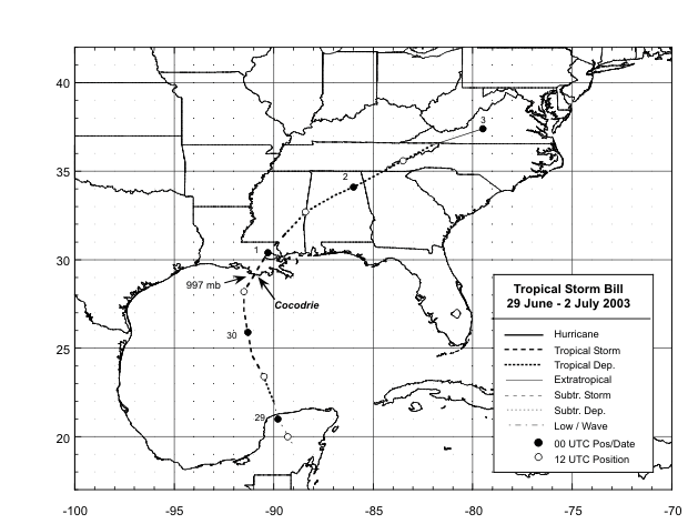
Figure 2:
Best track positions for Tropical Storm Bill, 29 June- 2 July,
2003. Track after landfall is based on analyses from the NOAA
Hydrometeorological Prediction Center.
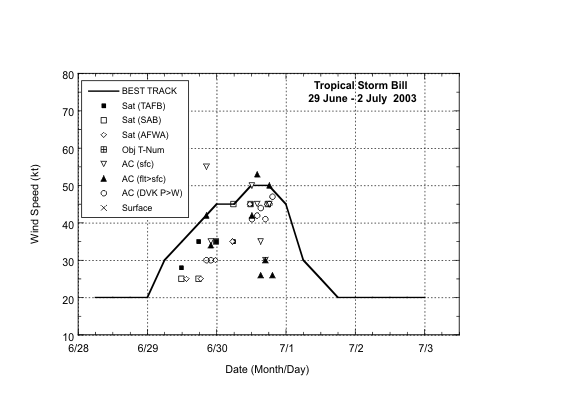
Figure 3a:
Selected wind observations and best track maximum sustained surface
wind speed curve for Tropical Storm Bill, 29 June-2 July, 2003.
Aircraft observations have been adjusted for elevation using 90%,
80%, and 80% reduction factors for observations from 700 mb, 850
mb, and 1500 ft, respectively. Estimates after landfall are based
on analyses from the NOAA Hydrometeorological Prediction
Center.

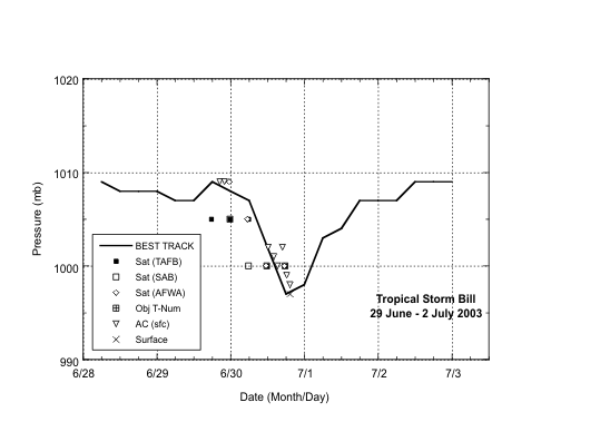
Figure 3b:
Selected pressure observations and best track minimum central
pressure curve for Tropical Storm Bill, 29 June-2 July, 2003.
Estimates after landfall are based on analyses from the NOAA
Hydrometeorological Prediction Center.

Figure 4:
Available track guidance
for Bill at 0600 UTC 30 June. The best track is given by the
easternmost gray line with positions given at 6 h intervals. Note
that 12 hour prior to landfall, none of the models indicated the
north-northeastward turn of Bill.
|