- Info
Malaria Modeling: OVERVIEW
Introduction, Objectives, and Benefits
Concept Design
Objective 1: Larval Habitat Detection
Objective 2: Dynamic Tranmission Modelling
Objective 3: Early Warning Modelling
Introduction, Objectives, and Benefits The Greater Mekong Subregion (GMS), which consists of Thailand, Myanmar, Cambodia, Laos, Vietnam, and the Yunnan Province of China, is the world's epicenter of multi-drug resistant falciparum malaria. Falciparum malaria accounts for approximately 50% of all malaria cases in Thailand, and approximately 80-90% of all cases in the countries surrounding Thailand. In the Malaria Modeling and Surveillance project, we have 3 objectives: - Identification of potential larval habitats
- Dynamic transmission modeling
- Prediction of malaria cases
The benefits are: - Reduced morbidity and mortality for the local populations
- Reduced damage to the environment
- Reduced likelihood of larvicide, insecticide, and drug resistance
| 
|
Concept Design We use NASA satellites, ground measurements, and commercial satellites data in this project. Results from NASA’s climate forecast model are also used for risk prediction. |  |
Objective 1: Larval Habitat Detection While the potential larval habitats with larger footprints can be easily identified in remotely sensed imagery data, it is more difficult to detect smaller larval habitats. We have developed textural-contextual techniques that can significantly improve classification accuracy of smaller habitats when satellite data with very high spatial resolution are used. |  |
| For example, irrigation and drainage ditches are important larval habitats of Anopheles sinensis. Our techniques can accurately identify these potential larval habitats. This particular test site is in Korea. |  |
Objective 2: Dynamic Transmission Modelling Our dynamic transmission model takes into the account of the detailed interactions among the vector life cycle, sporogonic cycle, and human disease cycle, under the influence of all external factors. | 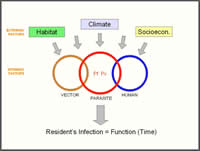 |
| An example for modeling is given here – a hamlet with 23 houses and 2 cattle sheds, which are surrounded by 24 larval breeding sites. Each household has 4 residents; and each resident has his or her own activity and immunity. This hypothetical hamlet is approximately 1/7 of a real test site. |  |
| These figures show what may happen over 1,000 days. Normally there are 2 transmission peaks per year in Thailand. A single, broad peak is used in this example to differentiate dry and wet seasons. Each color represents a different mosquito loading. The actual Entomological Inoculation Rate in Thailand is lower than what are shown here. |  |
| Mean and mean±1σ of these two variables are shown in these figures. |  |
| Our transmission model will be validated with field data collected at Ban Kong Mong Tha, an AFRIMS test site in Thailand. |  |
Objective 3: Early Warning Modelling Our risk prediction model uses meteorological parameters derived from satellite or ground-based measurements. In this example, precipitation is from a Tropical Rainfall Measuring Mission (TRMM) product. |  |
| Surface temperature shown in these figures is from a Moderate-Resolution Imaging Spectroradiometer (MODIS) product. |  |
| Tak Province often ranks highest in malaria case rates in Thailand. Here we use 8 years of meteorological and environmental data along with malaria cases to train a nonparametric model. The trained model is then used to hindcast the malaria cases in the following two years. It is seen that meteorological and environment variables may not account for all the variations. |  |
| Socioeconomic, political, and medical factors all have important roles in malaria transmission. For Thailand, non-Thai populations may be an important factor in maintaining the endemicity in the overall population. As shown in this figure, displaced and migrant populations account for a significant portion of the Tak population. |  |
| Located at the Thai-Myanmar border, the Tak Province has a number of refugee camps. Mae La Camp, with approximately 30,000 refugees, is the largest camp in Thailand. The health care in the refugee camps is provided by Non-Governmental Organizations (NGOs). Registered migrant workers are entitled to health care at Thai government’s facilities. |  |


