
Travis County
Maps
NEW! Use the interactive map on the Google Maps web site to find your commissioner's precinct.
FEMA releases
preliminary Flood Insurance Rate Maps and Flood Insurance Studies for Travis
County. More...
Travis County Department of Transportation and Natural Resources
Water and Wastewater
Service Providers
|
 |
 |
Travis County Downtown Complex
Precinct/Road Maps
Interactive Map of Travis County
(On Google Maps web site)
Capital Improvement Projects
CIP Project Details Maps
Airport Boulevard Offices
The Tax Office and some divisions of the County Clerk's Office have moved from their downtown locations to 5501 Airport Blvd.
Tax Office Satellite Locations
The Tax Office has also established satellite offices
in other parts of the county.
4011 McKinney Falls Parkway - Map
8656 Hwy 71W - Map
15822 Foothill Farms Loop, Pflugerville - Map
4705 Heflin Lane - Map
See locations
video.
Services for the Deaf & Hard of Hearing
Counseling and Education Services
Reagan Map
Service Center Map
(The intake center has moved to 1101 Nueces. See the downtown
map for details.
Endangered Species Habitat and Potential Preserve System
Countywide habitat map |
Quadrants links will take you to the specified quadrant's map. New quadrant maps are created and made available as requested. For more information contact BCCP coordinator Jennifer Brown . These files require Adobe Acrobat Reader to view or print. The reader can be downloaded free from Adobe. |
||||||||||||||||||||||
|


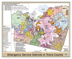
Emergency Services
Emergency
Services Districts Map
Library Districts
East Travis Gateway Library District
Municipal Jurisdictions
 There
are 22 distinct municipal jurisdictions in Travis County.
There
are 22 distinct municipal jurisdictions in Travis County.
Municipal Jurisdictions Map - 2.7 Mb
This file requires Adobe Acrobat Reader to view or print. The reader can be downloaded free from Adobe.