| 600 |  |
Lieutenant Edward J. Brown with portable pendulum gravity measuring apparatus. |
|
601 |  |
Working at the Cheltenham Magnetic Observatory. |
|
602 |  |
Field magnetic observations. |
1930 ca. |
603 |  |
Strong motion seismograph for use in earthquakes so strong as to wreck the more sensitive ordinary seismograph. Only six in U.S. They will record through any disturbance unless the building collapses. Gives data on earthquakes near epicenter. Observers carry special police cards to allow going into dangerous areas to take readings. |
1930 ca. |
604 |  |
Chief Survey Technician removing seawater from Nansen bottle for analsyis. |
1965 ca. |
605 |  |
C&GS Atlantic Marine Center ship base prior to renovation. |
Virginia, Norfolk 1961 March 14 |
606 |  |
Current meter. |
|
607 |  |
Operating portable 808 Fathometer recording system on survey launch. Human recorder is entering depths as called out by fathometer operator and also records navigational information called out by left and right anglemen not seen in picture. |
1950 ca. |
608 |  |
Instrument racks, teletypes, and computer tapes (including paper tapes) on C&GS vessel circa 1970. Survey technician entering data or instructions for computer. Hydrographic survey operations. Box in upper right is navigational interface for medium frequency navigation system such as Raydist or HiFix. |
1970 ca. |
609 |  |
Shoran ground station at West Point on Puget Sound near Seattle. This installation was used during some of the calibration work on Shoran during the early part of 1946. |
|
610 |  |
That's the spirit! Proud ship's cook displays 162nd anniversary of Coast and Geodetic Survey cake at Norfolk Atlantic Marine Center. |
Virginia, Norfolk 1969 February 10 |
611 |  |
One of a sequence in the erection of a Shoran Mast at Ground Station RAN on Murder Point, west of Massacre Bay, Attu Island, |
Alaska, Attu Island, Aleutians 1945 September |
612 |  |
Components of an early electronic navigation system. Possibly Shoran. |
|
613 |  |
Shoran antenna secured on radar antenna. |
Alaska, Aleutian Islands 1945 September |
614 |  |
Personnel from NOAA's Atlantic Marine Center update the hydrography and evaluate sounding data on the nautical chart for the Cooper River. |
South Carolina, Charleston 1971 ca. |
615 |  |
Radio operator Paul Scott on the NOAA Ship WHITING. |
Atlantic Ocean 1971 October |
616 |  |
Taking the sounding when the leadline is vertical. Sounding chair extended from top of deckhouse. See image theb2128. Sounding taken off C&GS Ship WESTDAHL. |
Alaska, Southeast 1936 ca. |
617 |  |
Plotting the field data in the ship's office. Note uniform of both officer and petty officer. Possibly on the C&GS Ship BACHE. |
Virginia, Norfolk 1916 July |
618 |  |
Upper- landing on Necker Island, Northwest Hawaiian Islands, during World Longitude Campaign, 1928. See theb0556. Lower - Signal built by C&GS on shoal used for visual navigation offshore survey of shoal areas. C&GS Ship HYDROGRAPHER (the first) to right of signal. |
United States Atlantic coast 1935 ca. |
619 |  |
Wiredrag operations on the C&GS Ships WAINWRIGHT and HILGARD. |
United States Atlantic coast 1955 ca. |
620 |  |
Wiredrag operations on the C&GS Ships WAINWRIGHT and HILGARD. |
United States Atlantic coast 1955 ca. |
621 | 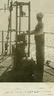 |
Deep sea sounding with electrically driven drum. |
1920 ca. |
622 |  |
120-foot hydrographic signal used on the Atlantic coast. |
United States Atlantic coast 1916 ca. |
623 |  |
Recovering a buoy during wiredrag operations on the C&GS Ships WAINWRIGHT and HILGARD. |
United States Atlantic coast 1955 ca. |
624 |  |
Hydrographic survey operations on the USS (aka USC&GS) BACHE. Note cgs00622 and cgs00627. Tall signal on dune used for offshore navigation by three-point sextant fix. |
Virginia 1916 |
625 |  |
Deep sea sounding gear rigged for work. Note cgs00626. |
1920 ca. |
626 |  |
Launch from the USC&GSS WESTDAHL taking soundings at Taku Glacier. |
Alaska, Taku Inlet 1937 |
627 |  |
Launch catamaran on hydrographic survey. Crew in action. Off C&GS Ship WESTDAHL, H. Arnold Karo, Chief of Party. |
Alaska, Stephens Passage. 1937 |
628 |  |
Artist's conception of fathometer sounding. |
1930 ca. |
629 |  |
Checking for index error of sextant prior to beginning hydrographic survey operations. |
1965 ca. |
630 |  |
Magnetic observations at sea from the USC&GSS BACHE. While steaming in a circle, first to the right and then to the left, the ship is steadied successive ly on 8 or 16 equi-distant headings while the sun's magnetic bearing is observed with the standard compass and the dip and total intensity are determined with a Lloyd-Creak dip circle. |
United States Atlantic coast 1916. |
631 |  |
Sounding by means of depth recorder demonstrated by Captain Clarence Burmister, USC&GS. Ca. 1945. |
1945 ca. |
632 |  |
Lowering transducer of portable 808 Fathometer system. |
Virginia, Norfolk 1940 ca. |
633 |  |
Wiredrag work in Alaska by the Coast and Geodetic Survey Ship EXPLORER. |
Alaska 1925 ca. |
634 |  |
Aerial view of Communipaw, Jersey City, New Jersey showing rail lines, piers, and ferry terminal (at lower right of photo.) |
New Jersey, Communipaw 1930 ca. |
635 |  |
Diagram of buoy for deploying Roberts Radio Current Meter. |
1960 ca. |
636 |  |
Buoy for deploying Roberts Radio Current Meter. |
1960 ca. |
637 |  |
Ground station equipment setup for calibration of Shoran. Operations off USC&GS Ship PIONEER. |
California, Oakland 1948 ca. |
638 |  |
Operating Shoran electronic navigation equipment. |
1950 ca. |
639 |  |
Checking 808 Fathometer recorder. |
1947 ca. |
640 |  |
Shoran installation on radar tower. First use of Shoran by USC&GS and first use of fully electronic navigation system. Shoran was modified from an aerial bombing navigation system called GEE, developed during WWII. Operations off of USC&GS Ship EXPLORER. |
Alaska, Agattu Island, Aleutians. 1945 |
641 |  |
Unhooking launch from ship. |
1960 ca. |
642 |  |
Newspaper article from the Virginian-Pilot detailing the development of automated hydrography. Commander Clinton D. Upham, a key figure in the development of early automated survey systems is on ESSA Launch 1257, a high-speed hydrographic survey launch. |
Virginia, Norfolk 1969 July 13 |
643 |  |
Different view of Saugerties Lighthouse than image cgs00569. |
New York, Hudson River, Esopus Creek 1910 ca. |
644 |  |
The tide gage at Anchorage at low tide. Staff is graduated in feet. |
Alaska, Anchorage 1910 ca. |
645 |  |
The tide gage at Anchorage at high tide. Staff is graduated in feet. |
Alaska, Anchorage 1910 ca. |
646 |  |
Ground station equipment set up in truck for calibration of Shoran. Operations off of USC&GS Ship PIONEER. |
California, Oakland 1948 ca. |
647 |  |
Ground station equipment set up in truck for calibration of Shoran. Operations off of USC&GS Ship PIONEER. |
California, Oakland 1948 ca. |
648 |  |
First whole operational season using Shoran electronic navigation system. Work accomplished by USC&GS Ships EXPLORER and SURVEYOR. Dotted lines are ship tracks controlled by Shoran. |
Alaska, Attu Island, Aleutians 1946 |
649 |  |
Shoran installation on radar tower. First use of Shoran by USC&GS and first use of fully electronic navigation system. Shoran was modified from an aerial bombing navigation system called GEE, developed during WWII. Operations off of USC&GS Ship EXPLORER. |
Alaska, Agattu Island, Aleutians. 1945 |

