| 2600 |  |
The camp at Alva. Triangulation party of Carl I. Aslakson |
Alva, Oklahoma Mid-December 1934 |
2601 |  |
Still a lot of tents but more and more trailers. The camp at Benjamin Triangulation party of Carl I. Aslakson |
Benjamin, Texas May 1935 |
2602 |  |
An all trailer camp - date and time unidentified. The days of the tent camps in the Lower 48 were over. |
|
2603 |  |
Comparison between tent camps and trailer camps. An overnight innovation - trailers became the only way to go in 1935. Triangulation party of Carl I. Aslakson |
April 1934 to May 1935 |
2604 |  |
Shorty and Novak at rest waiting for night observations. Camp on Gulf of Mexico |
1954 |
2605 |  |
Camp on the Porcupine River |
1955 |
2606 |  |
Camp on the Porcupine River |
1955 |
2607 |  |
Astro camp at Pop Lake, Alaska |
1955 |
2608 |  |
Camp at Wide Bay, Alaska |
|
2609 |  |
Taking a shower - Alaska style |
|
2610 |  |
Bear bait - sometimes this was the best that could be done for a camp |
|
2611 |  |
Birdseye view of an orderly campsite |
|
2612 |  |
Bob Pryce - the well-dressed field man |
|
2613 |  |
Camping in the mountains |
|
2614 |  |
Camping in the bush |
|
2615 | 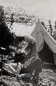 |
Waiting for dinner at the end of a long day |
|
2616 |  |
Camp in the thickets |
Alaska Peninsula 1944 |
2617 |  |
Camp at Bettles, Alaska. Just above the Arctic Circle |
Bettles, Central Alaska 1955 |
2618 |  |
Camp at Bettles, Alaska. Just above the Arctic Circle |
Bettles, Central Alaska 1955 |
2619 |  |
Camp haircut at Pop Lake |
Alaska 1955 |
2620 |  |
Beach erosion studies. As property values increased, beach erosion studies became important. Raymond Stanton Patton, Director of C&GS 1929-1938, was a pioneer in this field |
Atlantic coast 1930 |
2621 |  |
Beach erosion studies. As property values increased, beach erosion studies became important. Raymond Stanton Patton, Director of C&GS 1929-1938, was a pioneer in this field |
Atlantic coast 1930 |
2622 |  |
Tsunami inundating Hilo, Hawaii. Note man on pier. This disaster provided impetus for C&GS to establish tsunami warning system |
Hilo, Hawaii April 1946 |
2623 |  |
Tsunami warning station established at Dutch Harbor, Alaska. Many warning stations established at permanent tide station installations |
1949 |
2624 |  |
Time lines for tsunami paths from various epicenters to Hawaii. |
|
2625 |  |
Earthquake uplift at McLeod Harbor, Montague Island. C&GS surveys followed Good Friday Alaska earthquake of 1964. 31 feet of uplift necessitated resurveys of many areas. Investigations off of HODGSON |
Montague Island, Alaska 1964 |
2626 |  |
Current buoys with lights, radar reflectors, and F.M. transceivers. C&GS surveys followed Good Friday Alaska earthquake of 1964. Current surveys conducted with hydrographic surveys. Investigations off of HODGSON |
Alaska 1964 |
2627 |  |
Landslide scar at Hanning Bay. C&GS surveys followed Good Friday Alaska earthquake of 1964. Earthquake triggered landslide in Hanning Bay. Investigations off of HODGSON |
Hanning Bay, Montague Island 1964 |
2628 |  |
Gravity observations with Worden Gravimeter. This instrument used for land ties for marine gravity surveys. Off of LESTER JONES |
Juneau, Alaska 1964 |
2629 |  |
Deployment of experimental deepsea tide gauge. Off the EXPLORER in the Gulf Stream |
Cape Hatteras area July 1966 |
2630 |  |
Deployment of experimental deepsea tide gauge. Off the EXPLORER in the Gulf Stream |
Cape Hatteras area July 1966 |
2631 |  |
IXTOC 1 oil well blowout in Bay of Campeche. Oil spill studied by RESEARCHER |
Bay of Campeche, Mexico 1979 |
2632 |  |
IXTOC 1 oil well blowout from helicopter platform on RESEARCHER |
Bay of Campeche, Mexico September 21, 1979 |
2633 |  |
Snarled anchor cable and current meter cables. Sometimes things go seriously wrong. Current studies in SE Alaska |
Southeast Alaska 1910? |
2634 |  |
Current pole on the PATTERSON. |
Alaska 1913 |
2635 |  |
Price Current Meter used on the SURVEYOR. |
Alaska 1922 |
2636 |  |
Ekman Current Meter used on the SURVEYOR. |
Alaska 1922 |
2637 |  |
Albert J. "Hoskie" Hoskinson helping deploy bi-filar current meter. Current party of Ralph W. Woodworth, lower left. Current studies in Boston Harbor. Newspaper clipping from Boston Post, June 20, 1926 |
Boston, Massachusetts 1926 |
2638 |  |
Scaling the tapes from recording current meters. Working on the OCEANOGRAPHER. |
North Carolina coast 1940 |
2639 |  |
Test designs for buoys for Roberts Radio Current Meters. Buoy designs by Elliott B. Roberts. Tests conducted on LESTER JONES |
Puget Sound, Washington 1941 |
2640 |  |
Simulated 10.8 knot current as buoy streamed from bow of test vessel. Buoy design for Roberts Radio Current Meter. Tests conducted on LESTER JONES |
Puget Sound, Washington 1941 |
2641 |  |
Simulated 6.4 knot current as buoy streamed from bow of test vessel. Buoy design for Roberts Radio Current Meter. Tests conducted on LESTER JONES |
Puget Sound, Washington 1941 |
2642 |  |
Components of Roberts Radio Current Meter. This meter was invented by Elliott B. Roberts. It was the first current system to telemeter current information. Buoy telemetry was an outgrowth of RAR radio-sono-buoy technology. Tests conducted on LESTER JONES |
Puget Sound, Washington 1942 |
2643 |  |
Roberts Radio Current Meter ready to be deployed. This meter was invented by Elliott B. Roberts. It was the first current system to telemeter current information. Buoy telemetry was an outgrowth of RAR radio-sono-buoy technology. Tests conducted on LESTER JONES |
Puget Sound, Washington 1942 |
2644 |  |
Streamlined buoy and Roberts Radio Current Meter ready for deployment. This meter was invented by Elliott B. Roberts. It was the first current system to telemeter current information. Buoy telemetry was an outgrowth of RAR radio-sono-buoy technology. Tests conducted on LESTER JONES |
Puget Sound, Washington 1942 |
2645 |  |
Preparing a streamlined buoy for planting with Roberts Radio Current Meter. Inventor Elliott B. Roberts kneeling next to buoy. It was the first current system to telemeter current information. Buoy telemetry was an outgrowth of RAR radio-sono-buoy technology. Tests conducted on LESTER JONES |
Puget Sound, Washington 1942 |
2646 |  |
Different configurations of Roberts Radio Current Meter. This meter was invented by Elliott B. Roberts. It was the first current system to telemeter current information. Buoy telemetry was an outgrowth of RAR radio-sono-buoy technology. Tests conducted on LESTER JONES |
Puget Sound, Washington 1942 |
2647 |  |
Streamlined buoy with Roberts Radio Current Meter. This meter was invented by Elliott B. Roberts. It was the first current system to telemeter current information. Buoy telemetry was an outgrowth of RAR radio-sono-buoy technology. Tests conducted on LESTER JONES |
Puget Sound, Washington 1942 |
2648 |  |
Oops!!! Buoy pulled under by strong currents under Golden Gate Bridge. In spite of the best laid plans, sometimes things go awry. Photo #1 of sequence |
Golden Gate, San Francisco, California 1949 |
2649 |  |
There!!! That's better. This time the buoy is staying above water. Buoy in Golden Gate - Alcatraz Island in background. Photo #2 of sequence |
Golden Gate, San Francisco, California 1949 |

