| 1450 |  |
Beginning the measurement of the Salt Lake City Base. Perhaps last use of Eimbeck base bar apparatus. Figure No. 7, Appendix No. 12. Part II, Report of the Superintendent ... 1897, p. 774 |
Salt Lake City, Utah 1897 |
1451 |  |
Duplex bar No. 15 on its trestles. Figure No. 5, Appendix No. 11. Part II, Report of the Superintendent ... 1897, p. 483. |
1897 |
1452 |  |
Duplex bars of Eimbeck base measuring instrument in contact. Figure No. 4, Appendix No. 11. Part II, Report of the Superintendent ... 1897, p. 483. |
1897 |
1453 | 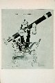 |
30 centimeter theodolite. Plate I, Fig. No. 7, Appendix No. 8, Report of Superintendent ... 1894, p. 276 |
1894 |
1454 |  |
Meridian and equal altitude instrument for astronomic observations. Fig. No. 28, Report of Superintendent ... 1867 |
1867 |
1455 |  |
Sorenson's engraving pantograph. Fig. No. 27, Report of Superintendent ... 1867 |
1867 |
1456 |  |
20 centimeter theodolite. Plate II, Fig. No. 8, Appendix No. 8, Report of Superintendent ... 1894, p. 276 |
1894 |
1457 |  |
Tidal indicator erected at Reedy Island on the Delaware River, Delaware. Figure No. 5, Appendix No. 9. Part II, Report of the Superintendent ... 1897, p. 483. This and two other indicators at New York and San Francisco built by C&GS. Face is thirty feet in diameter |
Reedy Island, Delaware River, Delaware 1897 |
1458 |  |
Stierle gauge as modified by the Coast and Geodetic Survey. Figure No. 4, Appendix No. 9. Part II, Report of the Superintendent ... 1897, p. 482 |
1897 |
1459 |  |
Stierle gauge as modified by the Coast and Geodetic Survey. Figure No. 3, Appendix No. 9. Part II, Report of the Superintendent ... 1897, p. 482 |
1897 |
1460 |  |
Avery's one-roller tide gauge. Figure 2, Appendix No. 9. Part II, Report of the Superintendent ... 1897, p. 481 |
1897 |
1461 |  |
Saxton self-registering tide gauge - model of 1853. Figure 1, Appendix No. 9. Part II, Report of the Superintendent ... 1897, p. 481 |
1897 |
1462 |  |
Clock-face view of modified Stierle tide gauge, model of 1896. Plate No. 5 of Appendix No. 7. Part II, Report of the Superintendent ... 1897, p. 318 |
1897 |
1463 |  |
Modified stierle tide gauge, model of 1896. Plate No. 4 of Appendix No. 7. Part II, Report of the Superintendent ... 1897, p. 318 |
1897 |
1464 |  |
Saxton self-registering tide gauge, model as of 1897. Plate No. 3 of Appendix No. 7. Part II, Report of the Superintendent ... 1897, p. 318 |
1897 |
1465 |  |
Magnetic declination and dip station. Observations at Boundary Marker No. 1. This was at the northernmost point on the Alaska-Canada Boundary. Party of J. T. Watkins - transportation by Coast Guard Cutter Bear |
Demarcation Point, Alaska August 15, 1921 |
1466 |  |
Magnetic observations by party of J. T. Watkins. Station was about 10 miles west of East Cape, Siberia. Transportation by Coast Guard Cutter Bear |
Near Whalen, Siberia August, 1921 |
1467 |  |
Magnetic observations by party of M. L. Cleven. |
Nome, Alaska Early summer 1947 |
1468 |  |
Magnetic observations by party of M. L. Cleven in east-central Alaskan Arctic. |
Saganavirktok River, Alaska Early summer 1947 |
1469 |  |
Observing magnetics with transit magnetometer at Station Mir 2. Party off of EXPLORER |
Amchitka Island, Aleutian Islands, Alaska June 12, 1949 |
1470 | 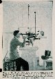 |
Observing absolute value of horizontal component of the Earth's magnetic field. |
Cheltenham Observatory, Maryland 1931 |
1471 |  |
Measuring absolute value of declination with a declinometer. |
Cheltenham Observatory, Maryland 1931 |
1472 |  |
Co-tidal lines of the world. |
1916 |
1473 |  |
Making magnetic observations for declination. |
Near Washington, D.C. 1931 |
1474 |  |
Chart showing isogonic lines for year 1900. Isogonic lines are lines of equal declination |
|
1475 |  |
Magnetic station near El Misti Volcano, Peru. Party of James Baden |
Arequipo, Peru 1947 |
1476 |  |
Transit magnetometer station. |
Southeast Alaska Ca. 1980 |
1477 |  |
Transit magnetometer station. Party off of PATHFINDER |
Island of Hawaii, Hawaii 1970 |
1478 |  |
Using compass declinometer for magnetic observations. Lt. Benjamin H. Rigg observing. Accompanied MacMillan Arctic Expedition. |
Greenland 1926 |
1479 | 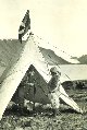 |
Lt. B. H. Rigg making magnetic observations in Canadian Arctic. Accompanied MacMillan Arctic Expedition |
Eastern Canadian Arctic 1926 |
1480 |  |
Lt. B. H. Rigg preparing to make magnetic observations in Canadian Arctic. Accompanied MacMillan Arctic Expedition |
Eastern Canadian Arctic 1926 |
1481 |  |
A Z-Variometer. Instrument measures relative changes in vertical component of Earth's magnetism |
1954 |
1482 |  |
Magnetic station at Hobhouse Inlet. Party of Joel Campbell |
Devon Island, Canadian Arctic 1946 |
1483 |  |
Lt. Charles A. Schoene observing magnetics at Little America IV. Schoene accompanied Operation High Jump |
Antarctica February 1947 |
1484 |  |
Magnetic observatory at Little America IV. Tent used for absolute observations while center building used for variation |
Antarctica February 1947 |
1485 |  |
Chart showing isogonic lines for year 1900. Isogonic lines are lines of equal declination |
|
1486 |  |
Brown Gravity Meter - a pendulum apparatus. |
Ca. 1935 |
1487 |  |
Brown Gravity Meter pendulum apparatus. |
Ca. 1935 |
1488 |  |
Observing gravity inside the cave at Station Jaggar. Party of E. J. Brown |
Summit of Mauna Loa, Hawaii 1927 |
1489 |  |
Gravity and radio apparatus on Necker Island. Observations as part of World Longitude Network. Party of E. J. Brown |
Necker Island, Hawaiian Islands 1928 |
1490 |  |
Lt. Joseph Lushene observing gravity in Bahamas. Cooperative project with the Navy and F. A. Vening Meinesz |
White Point, Bahamas Islands 1932 |
1491 |  |
Lt. Carl Aslakson observing gravity during South American expedition. |
Somewhere in South America 1941 |
1492 |  |
Measurements in strain in rock at Dugway Proving Ground. |
Dugway Proving Ground, Utah 1952 |
1493 |  |
Why the rock was being strained. 1/2 scale explosion at Dugway Proving Ground |
Dugway Proving Ground, Utah 1952 |
1494 |  |
Triangulation observations following major earthquake. |
Dixie Valley, Nevada 1955 |
1495 |  |
Triangulation observations following major earthquake. |
Dixie Valley, Nevada 1955 |
1496 |  |
Lieutenant Harley Nygren conducting gravity observations for Sandia Corporation. |
New Mexico 1955 |
1497 |  |
Reproduction of first map showing magnetic declination in the United States. First published by the Coast Survey in 1856 |
1856 |
1498 |  |
Underground magnetic observatory built at the University of Wisconsin in 1870's. Built under direction of Coast Survey. Observations made to Coast Survey specifications. One of many academic geophysical observatories built under guidance of C&GS |
Madison, Wisconsin 1879 |
1499 |  |
Magnetic observations along the Yukon River. |
Yukon River, Alaska Ca. 1924 |

