|
|
The National Soils Program Leader assists field specialists in attaining the Chief's soil priorities and managing resources from a healthy ecosystem perspective. The program focus is on soil productivity, sustainability,
and inventories.
The history of every nations is eventually written
in the way it cares for its soil
Franklin D. Roosevelt
|
 |
Soil Spot Light
Using Woody Biomass to Produce Bio-oil and BioChar - Briefing Paper: Stay tuned!
Dig It -- Soil Secrets @ the Smithsonian: Taking it on the Road
Travel Campaign PDF 976 KB
NRCS Newsletter
NRCS (Natural Resources Conservation Service) newsletters are available online.
The February 2009 issue provides information on the 2009 National Cooperative Soil Survey Conference in Las Cruces, New Mexico
Soil Management Around the World: National Geographic Article (html) September 2008
Soil Makes the Big Screen..."Dirt - The Movie"
Dirt - The Movie is a Sundance 2009 official selection. Miss Sundance? Check out the clips online
Narrated by Jamie Lee Curtis. "A story of heart and soil"
Contact the Directors and see if you can host the movie in your community -- great outreach and environmental education opportunity.
Naturally Occurring Asbestos
The National Field Soil Scientist Award
Deborah Page-Dumroese, Thomas Rice & Ann Abbott
Moscow Forest and Woodlands Program - Rocky Mountain Research Station
Debbie, Tom, and Ann were nominated by three Regions, and are recognized for their leadership and field efforts to scientifically standardize soil quality monitoring procedures. Their work includes the crafting the National Soil Disturbance Monitoring Protocol, developing the Soil Disturbance Field Guide, and designing the soil monitoring corporate database. Their field training sessions in five Regions ground-truthed the collaborative methodology, while their briefings with senior leadership insured the protocol was on course to address land management concerns.
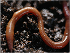
Invasive Earthworms
Add WORMS to your invasive species concerns list - it isn't just plants and mussels or snake head fish. Invading exotic earthworms are causing big problems. Note from National Soil Program Leader, Randy Davis, " I had no idea that earthworms could be a bad thing, but apparently in some parts of the country they have proven to be just such a thing. My understanding is that they decompose plant litter and denude the surface soil thereby increasing the risk of accelerated soil erosion." Minnesota, for example, has no native earthworms. The Minnesota ecosystem evolved without earthworms as part of their decomposition process.
More information...
Smithsonian Institute: Dig It! The Secrets of Soil
The Smithsonian Institute's Soil Exhibit: Dig It! The Secrets of Soil opened in the National Natural History Museum (NNHM) on July 19, 2008. Already thousands of visitors have visited the exhibit over the initial weekend. The exhibit will run for eighteen months in the NNHM then will travel across the United States for three years or more. The exhibit is cosponsored by the Soil Science Society of America with USDA the major federal partner in funding and guiding the development of the "first of its kind" soil exhibit. The floor plan and the fact sheet offer an overview of the exhibit's contents.
Inventory
- Earth Day, Wetlands Maps – One Year Later: April 22, 2009
The Fish and Wildlife Service maps of its National Wetlands Inventory are available for viewing on Google Earth. Since its launch one year ago, over 1.4 million maps of wetlands data have been downloaded using this versatile, fast program. If you don't have Google Earth, the Service’s Wetlands Mapper, a separate site, fully integrates digital data with printable customized maps.
- National Hierarchy on Ecological Units
- Forest Service Strategy; SRI TEUI Completion Briefing (pdf 19 KB)
- Explains what the map is portraying as a national strategy to complete initial SRI/TEUI on all NFS lands
- Forest Service FLAG Map (pdf 149 KB)
- Federal Land Advisory Group (FLAG). The map is a concept for completing the initial SRI/TEUI on the remaining areas of NFS lands.
- Natural Resource Conservation Service: Web Soil Survey
- LIDAR for soil resource inventory ppt (19 MB)
- TEUI Technical Guide and the TEUI Geospatial Toolkit:
The TEUI-Geospatial Toolkit is a comprehensive and innovative resource-mapping application designed to implement the mapping standards in the Forest Service Terrestrial Ecological Unit Inventory (TEUI) Technical Guide. TEUI is a land-survey system used by the Forest Service to classify and map ecological types that provide baseline information for resource management. The TEUI-Geospatial Toolkit directly supports field units, streamlines the collection of standard inventory, and provides management with a cost savings alternative to traditional inventory methods. It provides non-technical resource specialists the efficient ability to access geospatial data, visualize landscapes, delineate ecological units, characterize environmental conditions, and migrate final products to NRIS-Terra. As baseline data are migrated into NRIS-Terra, resource planners have access to consistent resource information for identifying ecosystem capabilities, determining sustainable production levels, and communicating sustainable management practices.
Technical Guide: US Department of Agriculture, Forest Service. 2005g. Terrestrial Ecological Unit Inventory Technical Guide. September 2005 GTR WO-68. pp.104. (pdf 2.74 MB)
Toolkit is available through USFS RSAC - FSWeb internal site
TEUI Briefing Paper - Posted 05/01/09: 293 KB PDF
- National Hierarchy on Ecological Units
Monitoring
Research
- Spot Lighted Research Articles
- Amacher, Michael C.; O’Neil, Katherine P.; Perry, Charles H. 2007. Soil vital signs: A new Soil Quality Index (SQI) for assessing forest soil health. Res. Pap. RMRS-RP-65WWW. Fort Collins, CO: U.S. Department of Agriculture, Forest Service, Rocky Mountain Research Station. 12 p.
Available through USFS Rocky Mountain Research Station/Tree Search
- Eldridge, D.J., W.G. Whitford. 2009. Badger (Taxidea taxus) disturbances increase soil heterogeneity in a degraded shrub-steppe ecosystem. Elsevier: Journal of Arid Environments (available to USDA employees through DigiTop). 73 (2009) 66-73. For purchase, visit Elsevier.
- Critical Loads Resources for Federal Land Managers
- Boerne, Ralph. 2008. Earth and Fire: Forests Rely on Healthy Soils for a Well-rounded Diet. Fire Science Brief (25)
- Soils Under Fire: Soils Research and the Joint Fire Science Program
USFS PNW-GTR 759
- * Bowker, M. A., J. Belnap, V. B. Chaudhary, N. C. Johnson. 2008. Revisiting classic water erosion models in drylands: The strong impact of biological soil crusts. Soil Biology and Biochemistry 40(9):2309-2316. pdf 577 KB
- * Bowker, M.A., M. E. Miller, J. Belnap, T. D. Sisk, and N. C. Johnson.
Prioritizing Conservation Effort through the Use of Biological Soil Crusts as Ecosystem Function Indicators in an Arid Region. (Not Yet Published) Conservation Biology Volume xx, No. x, 2008
pdf 452 KB
Soil Crust Photograph Gallery
- * Trumbore, S. E., and C. I. Czimczik. An Uncertain Future for Soil Carbon.
www.sciencemag.org, Science; vol. 321, 12 September 2008; 1455 - 1456. pdf 306 KB
- * Brantley, S. L. Understanding Soil Time.
www.sciencemag.org, Science; vol. 321, 12 September 2008; 1454 - 1455. pdf 172 KB
- Acid deposition effects on soil chemistry and forest growth on the Monongahela National Forest. Thesis. Patricia E. Elias. July 2008. Virginia Polytechnic Institute & State University.
pdf 3.06 MB
- New Progress In Soil Ecology
Science Daily News Article: 11.06.2008
The loss of organic matter is a threat to soil quality. Agricultural soils as well as mountain soils are both at risk. Both function as carbon sinks, and, under the impact of climate warming, could become sources greenhouse gas emissions. Near-infrared spectroscopy is a very promising avenue able to quantify the build-up of carbon in the soils at a large scale.
- Earthworm Activity Can Alter Forests' Carbon-carrying Capabilities
Science Daily News Article: 11.06.08
Earthworms can change the chemical nature of the carbon in North American forest litter and soils, potentially affecting the amount of carbon stored in forests. Scientists want to determine the earthworms' effect on forest chemistry by comparing carbon composition in forests that vary in earthworm activity.
* USDA Employees can access journal articles through DigiTop. Request a proxy and access on the road or at home.
Subject Matter Expertise (SME)
- LIDAR Training - Internal Geotraining website
- Introduction to Lidar: http://fsweb.geotraining.fs.fed.us/tutorials/lidar_intro/
- Fusion Tutorial: http://fsweb.geotraining.fs.fed.us/tutorials/fusion/
- USGS Lichen Field Guide Available
"A Field Guide to Biological Soil Crust of Western US Drylands - Common Lichens and Bryophytes"
This guide contains pictures, keys and distribution maps for 65+ species commonly encountered. It is intended for field use and thus the keys emphasize characteristics distinguishable in the field, rather than those needing a microscope. This field guide can be obtained by emailing cparry"at"usgs.gov, and is also posted as a PDF.
Down load USGS Field Guide
- The Ecology and Management of Biological Soil Crusts - Training
The Role of Biological Soil Crusts in Range Health: BLM-TC-1730-41
Biological Soil Crusts - Ecology and Management: BLM-TC-1730-41
BLM Training - http://doilearn.gov - search the Public Catalog
Dates: April 29-May 1, 2009
Location: Moab, Utah
Tuition: $250 for non-BLM Empoyees
Contact: Mark Phillips, 602-906-5552
More information
- Geospatial, instructor-led courses are being offered at the Forest Service's Eastern-Southern National University (ESNU). ESNU is taking place in Columbus, OH, March 16-27. Following Geospatial trainings are the being offered:
- Introduction to ArcGIS 9.2
- Deriving Natural Resource Information from Imagery
- Fire Incident Mapping Tools for ArcGIS
- Understanding and Exploring Lidar Data for Natural Resource Applications
- Data Production and Editing Techniques using ArcGIS
- Using Your Aerial Photography
- Automated Information Extraction from High-resolution Natural Resource Imagery
- Principles of Modeling
- Mapping-grade GPS for Natural Resource Applications
- ArcGIS Desktop III: GIS Workflows and Analysis
- Using the Terrestrial Ecological Unit Inventory (TEUI) Toolkit
- Managing Workflows in USFS Enterprise Geodatabases (ArcSDE and the FS Data Center)
- Conducting and Automating Geospatial Analysis Using ArcGIS and ModelBuilder
- Policies and Procedures for Accurate USFS Motor Vehicle Use Map (MVUM) Production
Contact: Stu Gregory, Geospatial Training, Geospatial Service and Technology Center,
US Forest Service, 801-975-3833, sgregory01"at"fs.fed.us
- GPS for Natural Resource Applications - Training. An Introductory course for use of GPS in resource work is available through RSAC/GSTC. It is a free Internal FS on-line course; you have to register before starting. FS employees - visit Internal FS WFW Soil page for link.
- De-compacting soil on the Bitterroot National Forest by Joel Gallob - Ravalli Republic
- USFS Tree Search: Forest Service Research Publications - use the search engine
- Forest Service Long Term Soil Productivity Brochure. Long Term Soil Productivity Research:
A National Program in Sustaining Forest Ecosystems
- Links
pdf: list of soil URLs
- Forest Service Articles on Sustainability. Articles: A Rationale For Forest Service Involvement In Sustainable Development; Sustainable Forest Management Questions; Criteria And Indicators For Sustainable Forest Management; An Approach to Working with Sustainability; A Discussion of Indicators of Sustainable Forest Management
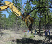 |
Photographs of Equipment featured in the article
"De-compacting soil on the Bitterroot NF"
|
|
The amount of decompaction is impressive.
Article correction:
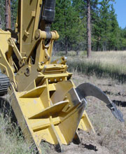
Tool created on the
Umpqua NF.
|
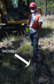 |
The second picture shows a treated area and the depth the shovel was easily inserted!
|
|
The 'thumb' can be used to scatter slash on disturbed areas.
|
 |
Administration
Conferences
|
|
- 2008 Western Regional Soil Survey Conference
- 2008 North American Forest Soil Conference
|
- 11th International Symposium on Wetland Biogeochemistry Biogeochemical Connections
June 23-25, 2009 Madison, Wisconsin
In this first year with Society of Wetland Scientists (SWS), the Symposium is being hosted at the annual SWS meeting, which runs June 22-26. Future Wetland Biogeochemistry Symposia may be held separate from the SWS annual meeting.
Abstract submission deadline is on Friday, February 27, 2009
Wetland Biogeochemical Flyer (pdf 45 KB)
More information...
Definitions
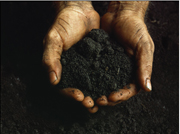
- Long Term Soil Productivity. Long-term monitoring and periodic sampling of soils provide information to adjust management practices that ensure the continued productivity of National Forest System lands.
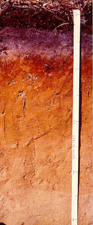
- Soil Inventories. Soil scientists collect, analyze and map basic soils and landscape information so that they can accurately assess land capability and suitability and evaluate impacts of natural disturbances and planned management activities.
Photos
|
![[Header with links to]: USDA Forest Service](https://webarchive.library.unt.edu/eot2008/20090510200712im_/http://www.fs.fed.us/biology/images/header_fs01.gif)