Tropical Cyclone Report
Hurricane Isidore
14 - 27 September 2002
Lixion A. Avila
National Hurricane Center
20 December 2002
Hurricane Isidore was a slow-moving tropical cyclone that hit
western Cuba as a category 1 hurricane (on the Saffir-Simpson
Hurricane Scale) and the northern Yucatan Peninsula as a category 3
hurricane. It made landfall on the Louisiana coast as a strong
tropical storm.
a. Synoptic History
A tropical wave moved off the coast of Africa on 9 September
accompanied by a large area of thunderstorms. The convective
activity decreased significantly as the system moved toward the
west-southwest during the next few days, but the wave maintained a
good low-cloud signature and cyclonic rotation. As the wave
approached 50 West, the shower activity began to increase and an
upper-level anticyclone became evident over the system. By 1800 UTC
14 September, there was enough convection and rotation to classify
the system as a tropical depression as it approached Trinidad and
the northern coast of Venezuela. The depression moved
west-northwestward and its development was halted by its
interaction with land. By 1800 UTC 15 September, the system had
degenerated into a tropical wave in the eastern Caribbean Sea.
However, as the wave entered the western Caribbean Sea, it
redeveloped a closed circulation and regained tropical depression
status at 1200 UTC 17 September, about 120 n mi south of Kingston,
Jamaica.
The depression became Tropical Storm Isidore around 0600 UTC 18
September, and, embedded within a weak steering current, the
tropical cyclone moved very slowly toward the northwest, passing
just west of Jamaica. Isidore then moved very slowly toward the
west-northwest across the Cayman Islands and became a hurricane at
1800 UTC 19 September. Its winds reached 90 knots around 0600 UTC
20 September as it was nearing the southwest coast of the Isle of
Youth, Cuba. Although the minimum pressure continued to drop,
Isidore's winds decreased a little bit and the hurricane made
landfall near Cabo Frances in western Cuba at 2100 UTC 20 September
with maximum winds of 75 knots. For more than 12 hours, Isidore
relentlessly pounded western Cuba. The hurricane then moved west
and southwestward toward the Yucatan Peninsula. Isidore
re-strengthened and reached its maximum intensity of 110 knots at
1800 UTC 21 September. However, its minimum central pressure of 934
mb occurred at 1200 UTC 22 September, just before landfall near
Puerto Telchac on the north coast of Yucatan.
Isidore meandered for 24 to 36 hours over northern Yucatan and
weakened to a minimal tropical storm. It then moved northward over
the Gulf of Mexico where the circulation expanded but the cyclone
never redeveloped an inner core of strong winds. Isidore made
landfall with winds of 55 knots and a minimum pressure of 984 mb
just west of Grand Isle, Louisiana at 0600 UTC 26 September. Once
it moved inland, Isidore weakened to a tropical depression and
moved north-northeastward across the southeastern United States,
producing torrential rains. It became an extratropical storm over
southwestern Pennsylvania at 1800 UTC 27 September, and was then
absorbed into a frontal zone.
The "best track" chart of the tropical cyclone's path is given
in Figure 1a and Figure 1b,
with the wind and pressure histories shown in
Figure 2and Figure 3,
respectively. The best track positions and
intensities are listed in Table 1.
b. Meteorological Statistics
Observations in Isidore (Figure 2 and Figure 3)
include satellite-based
Dvorak technique intensity estimates from the Tropical Analysis and
Forecast Branch (TAFB), the Satellite Analysis Branch (SAB) and the
U. S. Air Force Weather Agency (AFWA), as well as flight-level and
dropwindsonde observations from flights of the 53rd
Weather Reconnaissance Squadron of the U. S. Air Force Reserve
Command and the NOAA hurricane reconnaissance plane. Fixes from
various Cuban radars, as well as data from the Cancun radar
received at the NHC in real time were very useful in tracking
Isidore. Data from the NOAA high altitude jet was used to analyze
the environment surrounding the hurricane and was ingested by
numerical models.
Isidore was upgraded to tropical depression status based on a
fix provided by a reconnaissance plane. It was a report of a poorly
defined center of 1009 mb with 20 to 25 knot southwesterly winds at
1500 feet around 1800 UTC 14 September. It was downgraded to a
tropical wave in the eastern Caribbean Sea the next day, when a
reconnaissance plane could not find a closed circulation.
Isidore moved very close to the south of Cayman Brac, which
reported sustained winds of 42 knots with gusts to 61 knots at 0325
UTC 19 September. During the time Isidore was moving nearby the
Isle of Youth, the eye contracted to 8 n mi, and based on data from
a dropsonde in the eyewall, surface winds were near 90 knots.
Thereafter, there was a slight weakening as suggested by data from
a reconnaissance aircraft. In fact, the official best track over
Cuba was adjusted with data provided by the Cuban Weather Service.
Surface observations from Cuba and a post-analysis of aircraft and
dropsonde data suggest that Isidore crossed Cuba with 75-knot winds
and not with the 85 knots indicated operationally. The minimum
pressure measured in western Cuba was 970 mb at Isabel Rubio, and
that station experienced gusts to 75 knots at 2140 UTC 20 September
and about 554 mm (21.7 in) of rain. Several locations in the area
reported the calm of the eye. There was a strong storm surge along
the south coast of Cuba in Playa Cajio, south of Habana and in
Ensenada de Cortes, Pinar del Rio. When Isidore was already in the
Gulf of Mexico, rainbands over Cuba produced a wind gust of 86
knots in an isolated tornado in the town of Candelaria at 1600 UTC
23 September.
Isidore's peak intensity of 110 knots at 1800 UTC 21 September,
was a compromised between adjusted aircraft flight-level winds and
satellite estimates. Although the winds remained unchanged, the
central pressure continued to drop to a minimum of 934 mb at 1200
UTC 22 September. At this time, the cloud pattern looked the best
one imagery and the three satellite agencies reported T-numbers of
6.5 on the Dvorak scale, corresponding to 127 knots. However,
aircraft data did not support such intensity.
The maximum winds reported by a station in Yucatan were gusts to
70 knots, with a minimum pressure of 969.9 mb at Merida around 2350
UTC 22 September as the western eyewall moved through the area.
Figure 4a and Figure 4b are radar images
showing the eye of Isidore making
landfall in western Cuba and Yucatan, respectively.
Later, when a weakened Isidore was heading for Louisiana, it
reached 55-knot winds based on data from the "Deepwater
Pathfinder", which reported sustained winds of 56 knots with
gusts to 71 knots and 20 ft waves at 1743 UTC 27 September. Because
Isidore was a large tropical cyclone, there were numerous
observations from ships of tropical storm force winds. Some of
these observations are given in Table 2
The Belle Chase Naval Air Station in Louisiana experienced
northeast winds of 50 knots with gusts 60 knots at 0155 UTC 26
September. This is the highest wind reported by any station as
Isidore made landfall in the Louisiana coast. The highest storm
surge reported along the U.S. coast was 8.3 feet and occurred at
Rigoletes, Louisiana and at Gulfport Harbor, Mississippi.
Additional selected surface observations from land stations and
data buoys are given in Table 3 and Table 4.
c. Casualty and Damage Statistics
Press reports indicate that there were 2 indirect deaths
attributable to Isidore in Merida, Mexico. One was electrocuted by
a downed power line, another died in a weather-related car crash.
Four direct and one indirect deaths occurred in the United States.
One was a marine fatality drowning from a rip current near Port
Fourchon, LA on 22 September when Isidore was still over Yucatan,
another one was a drowning in a vehicle parked near a casino in
Mississippi when storm surge inundated the parking lot. A third
died when a tree fell across his car in eastern Mississippi, and
the forth one died after driving into 10 feet of water in
Clarksville, Tennessee. The indirect death occurred in Mississippi
when a man suffered from a cardiac arrest and could not be reached
by rescuers due to floodwaters.
Damage from Isidore in Jamaica was mainly related to torrential
rains. Western Cuba and Yucatan were severely damaged by the
hurricane primarily the agriculture and cattle industry. According
to Tropical Cyclone Reports from the weather services of Cuba and
Mexico, numerous houses and power lines were damaged by wind.
In the United States, the Property Claim Services Division of
the Insurance Services Office reports that insured losses due to
Isidore totaled 165 million dollars. Using a two to one factor for
insured to overall damage gives a total damage estimate of $330
million. Most of the damage occurred in Louisiana.
d. Forecast and Warning Critique
Average official track errors (with the number of cases in
parentheses) for Isidore were 32 (31), 55 (31), 73 (29), 101 (27), and
177 (23) n mi for the 12, 24, 36, 48, and 72 h forecasts,
respectively. These errors are lower than the average official
track errors for the 10-yr period 1992-2001 of 43, 81, 115, 148,
and 222, respectively. Table 5 which includes the track model
errors indicates that the NCEP global model (GFS) performed
remarkably well with errors lower than the official forecast
errors. Furthermore, the U.S. Navy global model (NGPS), which has
been upgraded this hurricane season, performed even better than the
GFS. These two global models captured the anomalous southward track
of Isidore over Yucatan. This uncommon southward track was not
taken into consideration in the official forecast and may have been
the cause of errors larger than these two models.
Average official intensity errors were 9, 16, 22, 30, and 46 kt
for the 12, 24, 36, 48, and 72 h forecasts, respectively. These
errors are higher than the average official intensity errors over
the 10-yr period 1992-2001 which are: 7, 11, 14, 16, and 19 kt,
respectively. Because the official track forecast kept Isidore over
water a continued strengthening was indicated. Instead, Isidore
moved over Yucatan and weakened, causing large intensity errors.
Tthe official intensity forecasts were correct in not predicting a
rapid intensification after Isidore moved back over the Gulf of
Mexico and headed for Louisiana.
Due to Isidore's track near many land areas, a large number of
watches and warnings were issued and coordinated with various
countries from the Caribbean region. They are summarized in
Table 6.
Table 1: Best track for Hurricane Isidore, 14-27 September,
2002. Positions and pressures given during the tropical wave stage
are representative values for the low-level vorticity center.
Date/Time
(UTC) | Position | Pressure
(mb) | Wind Speed
(kt) | Stage |
Lat.
(°N) | Lon.
(°W) |
| 14 / 1800 | 10.0 | 60.5 | 1009 | 25 | tropical depression |
| 15 / 0000 | 10.2 | 62.4 | 1009 | 25 | " |
| 15 / 0600 | 10.6 | 64.3 | 1009 | 25 | " |
| 15 / 1200 | 11.2 | 66.4 | 1009 | 25 | " |
| 15 / 1800 | 12.3 | 68.5 | 1009 | 25 | tropical wave |
| 16 / 0000 | 14.2 | 70.5 | 1009 | 20 | " |
| 16 / 0600 | 15.0 | 71.9 | 1008 | 20 | " |
| 16 / 1200 | 15.5 | 73.2 | 1008 | 20 | " |
| 16 / 1800 | 15.7 | 74.5 | 1008 | 20 | " |
| 17 / 0000 | 15.8 | 75.3 | 1008 | 25 | " |
| 17 / 0600 | 15.8 | 76.1 | 1008 | 25 | " |
| 17 / 1200 | 15.9 | 76.8 | 1008 | 30 | tropical depression |
| 17 / 1800 | 16.3 | 77.4 | 1006 | 30 | " |
| 18 / 0000 | 16.7 | 77.7 | 1006 | 30 | " |
| 18 / 0600 | 17.1 | 78.1 | 1006 | 35 | tropical storm |
| 18 / 1200 | 17.7 | 78.5 | 1004 | 40 | " |
| 18 / 1800 | 18.7 | 78.6 | 1001 | 45 | " |
| 19 / 0000 | 19.3 | 79.3 | 998 | 50 | " |
| 19 / 0600 | 19.7 | 80.4 | 990 | 50 | " |
| 19 / 1200 | 19.9 | 80.9 | 990 | 60 | " |
| 19 / 1800 | 20.4 | 81.7 | 983 | 65 | hurricane |
| 20 / 0000 | 20.7 | 82.3 | 979 | 75 | " |
| 20 / 0600 | 21.1 | 83.0 | 967 | 90 | " |
| 20 / 1200 | 21.5 | 83.5 | 966 | 85 | " |
| 20 / 1800 | 21.8 | 84.0 | 965 | 75 | " |
| 21 / 0000 | 22.1 | 84.3 | 964 | 75 | " |
| 21 / 0600 | 22.3 | 85.1 | 964 | 85 | " |
| 21 / 1200 | 22.0 | 85.8 | 955 | 100 | " |
| 21 / 1800 | 21.9 | 86.1 | 946 | 110 | " |
| 22 / 0000 | 22.1 | 86.5 | 947 | 110 | " |
| 22 / 0600 | 22.0 | 87.4 | 936 | 110 | " |
| 22 / 1200 | 21.9 | 88.2 | 934 | 110 | " |
| 22 / 1800 | 21.6 | 88.9 | 935 | 110 | " |
| 23 / 0000 | 21.0 | 89.4 | 950 | 100 | " |
| 23 / 0600 | 20.6 | 89.6 | 952 | 70 | " |
| 23 / 1200 | 20.1 | 89.6 | 960 | 60 | tropical storm |
| 23 / 1800 | 20.3 | 89.4 | 968 | 50 | " |
| 24 / 0000 | 20.5 | 89.3 | 980 | 35 | " |
| 24 / 0600 | 21.0 | 89.5 | 985 | 45 | " |
| 24 / 1200 | 21.7 | 89.7 | 987 | 50 | " |
| 24 / 1800 | 22.1 | 89.8 | 988 | 50 | " |
| 25 / 0000 | 23.0 | 89.7 | 987 | 50 | " |
| 25 / 0600 | 24.2 | 89.7 | 987 | 50 | " |
| 25 / 1200 | 25.4 | 90.2 | 990 | 50 | " |
| 25 / 1800 | 26.3 | 90.4 | 988 | 55 | " |
| 26 / 0000 | 27.5 | 90.3 | 989 | 55 | " |
| 26 / 0600 | 29.1 | 90.3 | 984 | 55 | " |
| 26 / 1200 | 30.0 | 89.9 | 985 | 55 | " |
| 26 / 1800 | 32.2 | 89.8 | 988 | 40 | " |
| 27 / 0000 | 33.0 | 89.0 | 992 | 20 | tropical depression |
| 27 / 0600 | 35.0 | 86.5 | 995 | 20 | " |
| 27 / 1200 | 39.1 | 82.9 | 998 | 20 | " |
| 27 / 1800 | 40.9 | 79.5 | 999 | 20 | extratropical |
| 28 / 0000 | | | | | absorbed |
| 22 / 1200 | 21.9 | 88.2 | 934 | 110 | minimum pressure |
| 20/ 2100 | 22.0 | 84.1 | 964 | 75 | landfall at Cabo Frances, Western Cuba. |
| 22/ 2100 | 21.3 | 89.3 | 936 | 110 | landfall at Puerto Telchac, Yucatan, Mexico. |
| 26/ 0600 | 29.1 | 90.3 | 984 | 55 | landfall just west of Grand Isle, LA. |
Table 2: Selected ship reports with
winds of at least 34 kt for Isidore, 14-27 September, 2002.
| Ship Name or Call Sign | Date/Time (UTC) | Lat.
(°N) | Lon.
(°W) | Wind dir/speed (deg/kt) | Pressure (mb) |
| PFRO | 19/0600 | 18.6 | 78.8 | 150/46 | 1004.0 |
| ELWX5 | 20/0200 | 25.0 | 80.0 | 140/33 | 1012.8 |
| C6FM7 | 20/0600 | 22.7 | 87.4 | 100/35 | 1006.0 |
| PDHU | 20/2100 | 24.5 | 83.4 | 080/37 | 1005.0 |
| ZCAQ8 | 20/2100 | 20.2 | 81.1 | 230/35 | 1005.1 |
| C6MF5 | 21/0600 | 23.1 | 80.6 | 100/40 | 1010.2 |
| LAZK4 | 21/0900 | 23.4 | 86.9 | 030/37 | 1002.0 |
| PCAW | 21/1200 | 20.8 | 83.8 | 150/39 | 1002.0 |
| LAZK4 | 21/1200 | 24.1 | 87.7 | 050/38 | 1002.0 |
| PFOH | 22/0000 | 21.5 | 84.7 | 180/39 | 1000.0 |
| C6YE | 22/0300 | 24.3 | 86.4 | 070/44 | 1000.5 |
| C6YE | 22/0900 | 23.4 | 85.7 | 100/44 | 999.4 |
| C6FM6 | 22/1200 | 25.0 | 89.7 | 050/42 | 1003.0 |
| C6YE | 22/1500 | 22.0 | 85.6 | 120/36 | 1001.4 |
| PGFE | 23/0600 | 19.8 | 95.2 | 310/39 | 1005.8 |
| PGFE | 23/0900 | 19.9 | 95.3 | 320/39 | 1005.8 |
| WPPO | 23/1200 | 26.6 | 89.5 | 090/40 | 1005.5 |
| VSCX4 | 23/1200 | 26.2 | 89.2 | 080/34 | 1007.5 |
| VSCX4 | 23/1500 | 26.7 | 90.1 | 070/37 | 1010.4 |
| PGFE | 23/1500 | 20.0 | 95.5 | 320/45 | 1006.9 |
| PGFE | 23/1800 | 19.9 | 95.6 | 310/41 | 1005.0 |
| PGFE | 23/2100 | 20.0 | 95.7 | 310/39 | 1004.2 |
| VSCX4 | 23/2100 | 27.6 | 92.0 | 050/35 | 1010.0 |
| PGFE | 24/0000 | 20.0 | 95.8 | 320/45 | 1004.5 |
| PGFE | 24/0600 | 19.9 | 95.6 | 310/45 | 1007.2 |
| PGFE | 24/0900 | 19.6 | 95.1 | 290/45 | 1005.0 |
| DGNB | 24/1100 | 25.0 | 84.9 | 130/35 | 1007.3 |
| C6FM6 | 24/1200 | 26.9 | 88.5 | 050/53 | 1006.0 |
| PGFE | 24/1200 | 19.5 | 94.7 | 290/41 | 1004.2 |
| H3GQ | 24/1200 | 27.2 | 90.5 | 040/44 | - |
| PGFE | 24/1500 | 19.6 | 94.6 | 300/45 | 1005.8 |
| PGFE | 24/1800 | 19.6 | 94.5 | 290/41 | 1005.1 |
| WGMJ | 24/1800 | 27.7 | 89.0 | 090/44 | 1005.5 |
| 3FZQ7 | 24/1800 | 28.2 | 88.4 | 040/34 | 1006.0 |
| PGFE | 24/2100 | 19.7 | 94.4 | 280/47 | 1002.7 |
| H3GQ | 24/2300 | 26.1 | 87.5 | 120/38 | - |
| DA367 | 25/0300 | 27.9 | 92.4 | 040/37 | 1005.0 |
| DGNB | 25/0300 | 27.0 | 90.2 | 070/35 | 1002.7 |
| DGNB | 25/0400 | 27.0 | 90.5 | 070/37 | 1002.7 |
| H3GQ | 25/0600 | 25.7 | 86.1 | 130/39 | 1005.0 |
| PGFE | 25/0600 | 20.0 | 94.0 | 290/39 | 1006.0 |
| DGNB | 25/0700 | 27.3 | 91.4 | 050/37 | 1001.2 |
| PGFE | 25/0900 | 20.0 | 93.9 | 290/44 | 1004.1 |
| DGNB | 25/1200 | 27.4 | 92.8 | 010/39 | 1001.4 |
| PGFE | 25/1200 | 20.1 | 93.9 | 290/41 | 1006.0 |
| VSXC4 | 25/1200 | 28.4 | 94.5 | 030/35 | 1010.4 |
| CGJN | 25/1200 | 29.2 | 87.5 | 100/35 | 1004.8 |
| DGNB | 25/1300 | 27.5 | 93.0 | 340/41 | 1001.4 |
| DGNB | 25/1400 | 27.5 | 93.1 | 340/39 | 1001.9 |
| PGFE | 25/1500 | 20.5 | 93.7 | 290/39 | 1007.1 |
| DGNB | 25/1500 | 27.6 | 93.1 | 320/43 | 1002.7 |
| VSCX4 | 25/1500 | 27.5 | 94.4 | 030/35 | 1006.5 |
| DGNB | 25/1600 | 27.6 | 93.2 | 340/37 | 1002.6 |
| DGNB | 25/1800 | 27.6 | 93.4 | 350/37 | 1002.3 |
| WRFJ | 25/1800 | 27.6 | 85.1 | 130/37 | 1008.3 |
| H3GQ | 25/1800 | 22.8 | 85.1 | 160/40 | 1005.0 |
| C6JN | 25/1800 | 29.0 | 87.3 | 120/39 | 1003.4 |
| C6YE | 25/1800 | 23.3 | 86.5 | 180/44 | 1002.0 |
| DGNB | 25/1900 | 27.7 | 93.6 | 350/37 | 1002.3 |
| DGNB | 25/2000 | 27.7 | 93.8 | 350/37 | 1002.1 |
| DGNB | 25/2100 | 27.7 | 94.0 | 350/39 | 1002.3 |
| C6FM7 | 25/2100 | 27.8 | 94.1 | 080/35 | 999.0 |
| C6JN | 25/2100 | 28.9 | 87.2 | 120/39 | 1000.0 |
| LANR5 | 25/2100 | 27.0 | 94.2 | 010/37 | 1001.9 |
| DGNB | 25/2300 | 27.6 | 94.4 | 350/35 | 1003.0 |
| 3FZQ7 | 25/2300 | 26.9 | 86.4 | 160/45 | 992.0 |
| C6JN | 26/0000 | 28.8 | 87.1 | 110/50 | 998.3 |
| PFAS | 26/0000 | 27.5 | 87.5 | 130/37 | 995.6 |
| C6YE | 26/0000 | 25.3 | 87.0 | 180/45 | 1008.5 |
| WRFJ | 26/0000 | 27.7 | 85.8 | 130/38 | 1002.7 |
| DGNB | 26/0200 | 27.5 | 94.9 | 340/35 | 1004.9 |
| C6JN | 26/0300 | 28.8 | 87.1 | 120/50 | 995.4 |
| GOVL | 26/0300 | 25.5 | 85.9 | 170/34 | 1002.5 |
| PEBP | 26/0600 | 26.6 | 84.4 | 140/41 | 1006.8 |
| WRFJ | 26/0600 | 28.0 | 85.4 | 130/42 | 1003.5 |
| GOVL | 26/0600 | 25.8 | 86.6 | 180/34 | 1000.8 |
| C6JN | 26/0600 | 28.8 | 87.0 | 140/49 | 995.0 |
| C6YE | 26/1200 | 29.2 | 87.6 | 150/36 | 994.0 |
| C6JN | 26/1500 | 28.6 | 87.0 | 200/40 | 997.0 |
| C6JN | 26/2100 | 30.1 | 88.6 | 220/38 | 995.4 |
|
Table 3: Table 3. Selected buoy and C-MAN observations for Isidore 14-27
September.
| | Minimum
Sea-level
Pressure | Maximum Surface Wind Speed
(kt) | |
| Location | Date/
Time
(UTC) | Press.
(mb) | Date/
Timea
(UTC) | Sust.
Windb
(kts) | Peak
Gust (kts) | Storm
Surgec
(ft) | Storm
Tided
(ft) | Rain
(storm total)
(in) |
| Gulf of Mexico |
| 42002 (25.2N 94.4W) | | | 25/2000 | 34 | 42 | | | |
| 42003 (25.9N 86.0W) | 25/2100 | 1000.2 | 26/0000 | 38 | 48 | | | |
| 42039 (28.8N 86.1W) | 26/0800 | 998.0 | 26/0800 | 38 | 45 | | | |
| 42040 (29.2N 88.2W) | 26/0900 | 989.5 | 26/0030 | 39e | 51 | | | |
| 42041 (27.5N 90.5W) | 26/0500 | 988.6 | 26/0700 | 34 | 40 | | | |
| 42007 (30.1N 88.8W) | 26/1200 | 987.1 | 26/0310 | 46e | 58 | | | |
| CSBF1 (29.7N 85.4W) | 26/1300 | 1001.1 | 26/0800 | 40 | 50 | | | |
| BURL1 (28.9N 89.4W) | 26/0900 | 984.7 | 25/2300 | 46 | 59 | | | |
| DPIA1 (30.3N 88.1W) | 26/0900 | 989.5 | 26/1000 | 42 | 52 | | | |
| GDIL1 (29.3N 90.0W) | 26/0900 | 986.6 | 26/0440 | 37e | 62 | | | |
aDate/time is for wind gust when both sustained and gust are listed.
bExcept as noted, sustained wind averaging periods for C-MAN and land-based ASOS reports are
2 min; buoy averaging periods are 8 min.
cStorm surge is water height above normal astronomical tide level.
dStorm tide is water height above National Geodetic Vertical Datum (1929 mean sea level).
e10-min |
Table 4: Table 4. Selected surface observations for Isidore, 14-27
September, 2002.
| | Minimum
Sea-level
Pressure | Maximum Surface Wind Speed
(kt) | |
| Location | Date/
Time
(UTC) | Press.
(mb) | Date/
Timea
(UTC) | Sust.
Windb
(kts) | Peak
Gust (kts) | Storm
Surgec
(ft) | Storm
Tided
(ft) | Rain
(storm total)
(in) |
| Jamaica |
| Kingston | 18/0900 | 1007.5 | 18/1045 | | 41 | | | |
| Cotton Tree Gully | | | | | | | | 27.2 |
| Mount Nelson | | | | | | | | 18.9 |
| Cedar Valley | | | | | | | | 18.9 |
| Cayman Islands |
| Cayman Brac | 19/0325 | 1001.0 | 19/0325 | 42 | 61 | | | |
| Isla de la Juventud, Cuba |
| 78324 Punta del Este | 20/1000 | 1000.6 | 20/1310 | 50 | 71 | | | 24.6 |
| 78321 La Fe | 20/1500 | 999.9 | 20/1045 | 54 | 72 | | | 19.6 |
| 78309 Cuba-Francia | 20/1100 | 999.5 | 20/1235 | 43 | 71 | | | 13.9 |
| 78221 Nueva Gerona | 20/1100. | 1004.2 | 20/1200 | 45 | 67 | | | 17.9 |
| Pinar del Rio, Cuba |
| 78310 Cabo San
Antonio | 21/0600 | 991.4 | | 37 | 57 | | | 14.6 |
| 78315 Pinar del Rio | 21/2100 | 990.9 | 20/2150 | 46 | 63 | | | 13.9 |
| 78317 Paso Real | 21/2220 | 995.7 | 21/1745 | 38 | 50 | | | 14.0 |
| 78313 Isabel Rubio | 21/2140 | 970.0 | 22/0030 | 54 | 74 | | | 21.7 |
| 78312 Santa Lucia | 21/0000. | 992.6 | | | | | | 6.3 |
| 78316 La Palma | 21/0000 | 993.6 | 22/0130 | | 53 | | | |
| 78318 Bahia Honda | 21/0000 | 1001.9 | 22/1540 | 53 | | | | 6.0 |
| 78314 San Juan | 21/2140 | 990.4 | 21/0045 | 37 | 58 | | | 17.6 |
| 78311 La Bajada | | | | | | | | 22.3 |
| Yucatan, Mexico |
| Merida | 23/0000 | 969.9 | 22/2350 | 43 | 70 | | | 5.8 |
| Alabama |
| Dauphin Island | 26/1300 | 989.5 | | | | | | |
| Mobile State Docks | | | | | | | 5.9 | |
| Middle Bay Light House | | | | | | | 6.1 | |
| Brookley Field | 26/1343 | 992.0 | 26/1129 | 40 | 50 | | | |
| Bay Minette | | | | | | | | 11.0 |
| Mobile | 26/1410 | 991.0 | 26/1226 | 42 | 50 | | | 8.7 |
| Semmes | 26/1345 | 991.0 | | | | | | 11.9 |
| Louisiana |
| Belle Chasse Naval Air | 26/1053 | 985.1 | 26/0155 | 50 | 60 | 7.48 | | |
| New
Orleans | 26/1207 | 985.1 | 26/0525 | 35 | 42 | | | |
| New Orleans Int. Airp. | 26/1147 | 985.8 | 26/0757 | 40 | 47 | | | 7.5 |
| Bootheville | 26/0953 | 985.8 | 26/0440 | | 37 | | | 5.3 |
| East Lake Pontchartrain | | | 26/0510 | | 36 | | | |
| Slidell | 26/1226 | 985.1 | | | | | | 4.4 |
| Rigoletes | | | | | | 8.3 | | |
| Sea Rim State Park | | | 25/2144 | | 35 | | | |
| Mississippi |
| Gulfport | 26/1359 | 987.1 | 26/0725 | | 43 | 8.26 | | 5.5 |
| Pascagoula | 26/1316 | 989.9 | 26/1310 | | 35 | | | 4.8 |
| Kessler | 26/1200 | 987.1 | 26/0155 | | 41 | | | |
| Point Cadet | | | | | | | | |
| Florida |
| Pensacola | 26/1153 | 995.0 | 26/0258 | | 44 | | 5.2 | 9.1 |
| Pensacola Naval Air (NPA) | | | 26/1256 | | 43 | | | 6.7 |
| Destin | | | 26/1221 | 35 | 45 | | | 6.1 |
| Eglin Air Force (VPS) | | | 26/1340 | | 46 | | | |
| Hurlburt Field (HRT) | | | 26/0839 | | 49 | | | |
| Pensacola Beach | | | 26/0130 | | 55 | | | |
| Perdido Key | | | 26/0330 | | 47 | | | |
| Pensacola Escambia | | | 26/0830 | | 49 | | | |
| Fort Walton Beach | | | 26/0807 | | 44 | | | |
| Apalachicola (ASOS) | | | 26/1258 | | 38 | | | |
| Panama City (ASOS) | | | 26/0653 | | 35 | | | |
aDate/time is for wind gust when both sustained and gust are listed.
bExcept as noted, sustained wind averaging periods for C-MAN and land-based ASOS reports are
2 min; buoy averaging periods are 8 min.
cStorm surge is water height above normal astronomical tide level.
dStorm tide is water height above National Geodetic Vertical Datum (1929 mean sea level). |
Table 5: Preliminary forecast evaluation
(heterogeneous sample) for Isidore, 14-27 September, 2002. Forecast
errors for tropical storm and hurricane stages (n mi) are followed
by the number of forecasts in parentheses. Errors smaller than the
NHC official forecast are shown in bold-face type.
| Forecast Technique | Period (hours) |
| 12 | 24 | 36 | 48 | 72 |
| CLP5 | 44 (30) | 96 (28) | 164 (26) | 240 (24) | 384 (20) |
| GFDI | 33 (32) | 58 (30) | 87 (28) | 115 (26) | 188 (22) |
| GFDL | 34 (29) | 52 (27) | 85 (25) | 119 (23) | 164 (20) |
| LBAR | 38 (30) | 84 (28) | 137 (26) | 201 (24) | 327 (20) |
| AVNI | 27 (30) | 43 (28) | 55 (26) | 68 (24) | 116 (20) |
| AVNO | 35 (30) | 45 (28) | 63 (26) | 75 (24) | 122 (20) |
| AEMI | 28 (26) | 49 (25) | 73 (23) | 99 (22) | 155 (19) |
| BAMD | 38 (30) | 67 (28) | 91 (26) | 133 (24) | 242 (20) |
| BAMM | 46 (30) | 77 (28) | 99 (26) | 139 (24) | 247 (20) |
| BAMS | 57 (30) | 95 (28) | 123 (26) | 161 (24) | 256 (20) |
| NGPI | 42 (33) | 60 (31) | 80 (29) | 100 (27) | 133 (23) |
| NGPS | 34 (33) | 45 (31) | 57 (29) | 78 (27) | 105 (23) |
| UKMI | 38 (32) | 74 (30) | 101 (28) | 132 (26) | 209 (22) |
| UKM | 31 (16) | 50 (15) | 100 (14) | 121 (13) | 194 (11) |
| A98E | 42 (30) | 74 (28) | 98 (26) | 131 (24) | 258 (20) |
| A9UK | 45 (15) | 77 (14) | 118 (13) | 158 (12) | 283 (10) |
| GUNS | 31 (33) | 53 (31) | 72 (29) | 95 (27) | 151 (23) |
| GUNA | 29 (32) | 47 (30) | 64 (28) | 85 (26) | 140 (22) |
| OFCL | 32 (31) | 55 (31) | 73 (29) | 101 (27) | 177 (23) |
| NHC Official (1992-2001 mean) | 43 (2199) | 81 (1965) | 115 (1759) | 148 (1580) | 222 (1272) |
| *Output from these models was unavailable at time of forecast issuance. |
Table 6: Watch and warning summary for Isidore, 14-27 September,
2002.
| Date/Time | Action | Location |
| 18/0300 | Tropical storm warning issued | Jamaica |
| 18/0300 | Tropical storm watch issued | Cayman Islands |
| 18/1500 | Tropical storm warning issued | Little Cayman and Cayman Brac |
| 18/1500 | Hurricane watch | Cuba from Villa Clara westward
including the Isle of Youth. |
| 18/1800 | Tropical storm warning extended | Grand Cayman |
| 19/0000 | Hurricane warning issued | Cienfuegos and Villa Clara westward
including the Isle of Youth. |
| 19/0000 | Hurricane watch extended | to include Santic-Spiritus and Ciego
de Avila |
| 19/0900 | Tropical Storm warning
discontinued | Jamaica |
| 19/2100 | Tropical storm watch issued | Lower Florida Keys west of the seven
mile bridge including Dry Tortugas. |
| 19/2100 | Hurricane watch discontinued | Cuba east of Matanzas |
| 20/1100 | Tropical storm warning
discontinued | Cayman Islands |
| 20/1500 | Tropical sorm watch discontinued | Lower Florida Keys west of the
seven |
| 20/1500 | Tropical storm warning and a
hurricanes watch | Yucatan from Progreso to Tulum
including Cozumel |
| 21/0900 | Hurricane warning issued | Cabo Catoche to Progreso and
Cozumel |
| 21/1100 | Hurricane warning extended | Tulum to Cabo Catoche |
| 21/1200 | All warnings discontinued | except for Pinar del Rio and the Isle
of Youth |
| 22/1000 | Hurricane warning extended | Yucatan from Progreso to
Campeche |
| 22/1500 | all warnings discontinued | Cuba for Pinar del Rio and the Isle
of Youth. |
| 23/0545 | Tropical Storm warning issued | Mexico from Campeche to
Veracruz |
| 23/0545 | Hurricane warning discontinued | Mexico from Tulum to Cabo
Catoche |
| 23/1500 | Hurricane warning replaced by
tropical storm warning | Cabo Catoche to Veracruz |
| 24/1500 | Hurricane watch issued | Cameron Louisiana to Pascagoula
Mississippi. |
|
24/1500 | Tropical storm warning issued | High Island Texas to Destin
Florida. |
| 24/2100 | Tropical storm warning
discontinued | Mexico west of Campeche |
| 25/1500 | Tropical storm warning extended | along the Florida coast to St.
Marks |
| 25/1500 | all warnings
discontinued | Yucatan |
| 26/0900 | Hurricane watch discontinued | Cameron to Pascagoula |
| 26/1500 | Tropical storm warning
discontinued | west of Morgan City, Louisiana |
| 26/1800 | Tropical storm warning
discontinued | west of the mouth of the Mississippi
River. |
| 26/2100 | All coastal warnings
discontinued | mouth of the of the Mississippi River
to St. Marks |
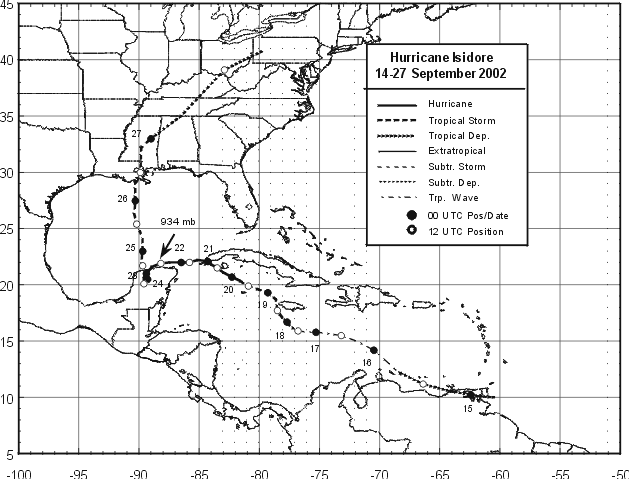
Figure 1a:
Best track positions for Isidore, 14- 27 September 2002. Track after 0000 UTC
27 September is based on analyses from NOAA Hydrometeorological
Prediction Center.

Figure 1b:
Best track positions for Isidore, 14- 27
September 2002 denoting the landfall points.
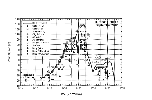
Figure 2:
Selected wind observations and best track
maximum sustained surface wind speed curve for Isidore, 14-27
September 2002. Aircraft observations have been adjusted for
elevation using 90%, 80%, and 80% reduction factors for
observations from 700 mb, 850 mb, and 1500 ft, respectively.
Dropwindsonde observations include actual 10 m winds (sfc), as well
as surface estimates derived from the mean wind over the lowest 150
m of the wind sounding (LLM), and from the sounding boundary layer
mean (MBL).
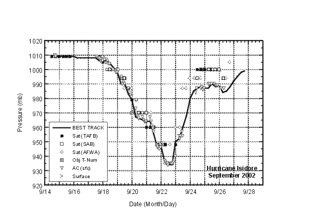
Figure 3:
Selected pressure observations and best
track minimum central pressure curve for Isidore, 14-27 September,
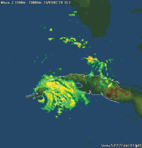
Figure 4a:
Image from Havana radar provided by
the Instituto de Meteorologia, Cuba during the time Isidore was
making landfall in western Cuba
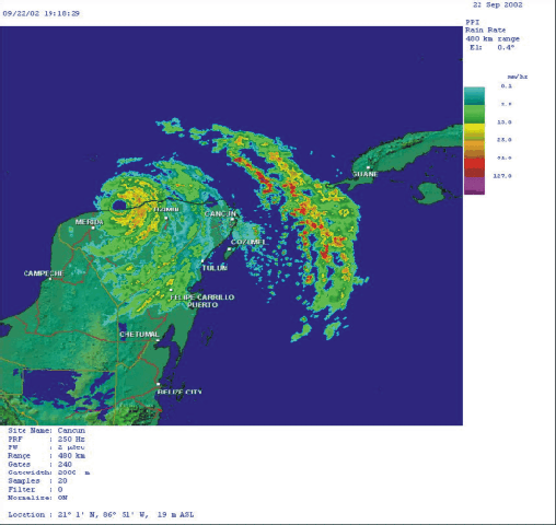
Figure 4b:
Image from Cancun radar provided by the Servicio Meterorologico
Nacional of Mexico during the time Isidore was making landfall near
Puerto Telchac, Yucatan.
|


