Tropical Cyclone Report
Tropical Storm Dolly
29 August - 4 September 2002
Lixion. A. Avila
National Hurricane Center
12 October 2002
Dolly was the first Atlantic basin tropical cyclone to develop
in the deep tropics in 2002.
a. Synoptic History
Dolly developed from a tropical wave that moved off the west
coast of Africa on 27 August. As the wave moved westward, ship
observations indicated that the wave was accompanied by an area of
low pressure and satellite images showed increasing thunderstorm
activity. The system moved west and west-southwest and became a
tropical depression at 1200 UTC 29 August about 550 n mi southwest
of the westernmost Cape Verde Islands. The depression quickly
became better organized, developing well-defined cyclonically
curved convective bands and good outflow in all quadrants. It
became a tropical storm by 1800 UTC on the same day and reached its
peak intensity of 50 knots and a minimum pressure of 997 mb at 1200
UTC 30 August. Dolly moved toward the west and west-northwest
around the periphery of a subtropical ridge for a couple of days.
Thereafter, tropical cyclone curved to the northwest and then north
ahead of a mid-level trough with a minor fluctuation in intensity
at 0000 UTC 3 September when convection decreased. It finally
became a remnant low late on 4 September when strong shear removed
most of the convection, and ultimately became absorbed by the
trough.
The "best track" chart of the tropical cyclone's path is given
in Figure 1,
with the wind and pressure histories shown in Figure 2
and Figure 3,
respectively. The best track positions and intensities are
listed in Table 1.
b. Meteorological Statistics
Observations in Dolly (Figure 2 and Figure 3)
include satellite-based
Dvorak technique intensity estimates from the Tropical Analysis and
Forecast Branch (TAFB), the Satellite Analysis Branch (SAB) and the
U. S. Air Force Weather Agency (AFWA). Operationally, the maximum
winds in Dolly were 55 knots at 1200 UTC 30 August based on a 3.5
Dvorak classification. However, a post-analysis of visible images
showed that the low level-center was not embedded completely within
the deep convection. This suggested that Dolly was a weaker
tropical cyclone and the maximum winds have been adjusted to 50
knots in the best track.
c. Casualty and Damage Statistics
There were no reports of damage or casualties associated with
Dolly.
d. Forecast and Warning Critique
Average official track errors (with the number of cases in
parentheses) for Dolly were 48 (21), 83 (19), 121 (17), 155 (15),
and 240 (11) n mi for the 12, 24, 36, 48, and 72 h forecasts,
respectively. These errors are slightly larger than the average
official track errors for the 10-yr period 1992-2001 which are 43,
81, 115, 148, and 222 n mi respectively. However, they are smaller
than nearly all of the numerical guidance models. A comparison of
the official forecast track errors with selected numerical guidance
is given in Table 2.
Average official intensity errors were 4, 8, 11, 14, and 15 kt
for the 12, 24, 36, 48, and 72 h forecasts, respectively. For
comparison, the average official intensity errors over the 10-yr
period 1992-2001 are 7, 11, 14, 16, and 19 kt, respectively.
Initially, Dolly was forecast to become a hurricane when it was
located in the deep tropics and the environment appeared to be
favorable. However, the cyclone turned northward into a shearing
environment and weakened instead.
Table 1: Best track for Tropical Storm Dolly, 29 August- 4
September.
Date/Time
(UTC) | Position | Pressure
(mb) | Wind Speed
(kt) | Stage |
Lat.
(°N) | Lon.
(°W) |
| 29 / 1200 | 9.5 | 31.2 | 1007 | 30 | tropical depression |
| 29 / 1800 | 9.7 | 32.2 | 1005 | 35 | tropical storm |
| 30 / 0000 | 9.7 | 33.1 | 1002 | 40 | " |
| 30 / 0600 | 10.0 | 34.5 | 1000 | 45 | " |
| 30 / 1200 | 10.3 | 36.3 | 997 | 50 | " |
| 30 / 1800 | 10.8 | 37.7 | 1000 | 50 | " |
| 31 / 0000 | 11.5 | 39.1 | 1000 | 45 | " |
| 31 / 0600 | 12.1 | 40.9 | 1002 | 40 | " |
| 31 / 1200 | 12.8 | 42.9 | 1005 | 35 | " |
| 31 / 1800 | 13.2 | 44.9 | 1005 | 35 | " |
| 01 / 0000 | 13.6 | 46.8 | 1005 | 35 | " |
| 01 / 0600 | 14.1 | 48.4 | 1005 | 35 | " |
| 01 / 1200 | 14.8 | 49.9 | 1005 | 35 | " |
| 01 / 1800 | 15.6 | 51.2 | 1002 | 40 | " |
| 02 / 0000 | 16.4 | 52.0 | 1001 | 40 | " |
| 02 / 0600 | 17.1 | 52.5 | 1001 | 40 | " |
| 02 / 1200 | 17.9 | 52.9 | 1000 | 45 | " |
| 02 / 1800 | 18.5 | 53.3 | 1002 | 45 | " |
| 03 / 0000 | 19.3 | 53.7 | 1002 | 40 | " |
| 03 / 0600 | 19.6 | 53.7 | 1000 | 45 | " |
| 03 / 1200 | 21.0 | 52.9 | 1000 | 45 | " |
| 03 / 1800 | 22.2 | 52.4 | 1001 | 45 | " |
| 04 / 0000 | 23.1 | 52.4 | 1001 | 45 | " |
| 04 / 0600 | 23.5 | 52.4 | 1005 | 35 | " |
| 04 / 1200 | 23.5 | 52.5 | 1009 | 25 | tropical depression |
| 04 / 1800 | 24.0 | 52.5 | 1009 | 20 | remnant low |
| 30 / 1200 | 10.3 | 36.3 | 997 | 50 | minimum pressure |
Table 2: Preliminary forecast evaluation
(heterogeneous sample) for Dolly, 29 August-4 September, 2002.
Forecast errors for tropical storm and hurricane stages (n mi) are
followed by the number of forecasts in parentheses. Errors smaller
than the NHC official forecast are shown in bold-face type.
| Forecast Technique | Period (hours) |
| 12 | 24 | 36 | 48 | 72 |
| CLP5 | 60 (21) | 110 (19) | 174 (17) | 239 (15) | 355 (11) |
| GFDI | 64 (21) | 122 (19) | 165 (17) | 230 (15) | 342 (11) |
| GFDL | 59 (21) | 109 (18) | 159 (16) | 212 (14) | 314 (10) |
| LBAR | 51 (21) | 77 (19) | 103 (17) | 137 (15) | 194 (11) |
| AVNI | 54 (21) | 96 (19) | 157 (17) | 223 (14) | 343 ( 7) |
| AVNO | 56 (21) | 87 (19) | 139 (17) | 192 (14) | 285 ( 6) |
| AEMI | 71 (14) | 145 (12) | 249 (11) | 73 ( 4) | |
| BAMD | 56 (21) | 92 (19) | 134 (17) | 186 (15) | 274 (11) |
| BAMM | 49 (21) | 88 (19) | 119 (17) | 167 (15) | 261 (11) |
| BAMS | 65 (21) | 129 (19) | 193 (17) | 262 (15) | 392 (11) |
| NGPI | 60 (20) | 99 (18) | 144 (16) | 199 (14) | 297 (10) |
| NGPS | 68 (21) | 96 (19) | 131 (17) | 188 (15) | 308 (11) |
| UKMI | 64 (20) | 88 (18) | 118 (16) | 157 (14) | 243 (11) |
| UKM | 58 (10) | 92 ( 9) | 99 ( 8) | 118 ( 7) | 200 ( 5) |
| A98E | 60 (21) | 94 (19) | 134 (17) | 197 (15) | 313 (11) |
| A9UK | 52 (10) | 89 ( 9) | 141 ( 8) | 223 ( 7) | 330 ( 5) |
| GUNS | 58 (19) | 97 (17) | 130 (15) | 182 (13) | 265 (10) |
| GUNA | 55 (19) | 92 (17) | 131 (15) | 179 (12) | 205 ( 6) |
| OFCL | 48 (21) | 83 (19) | 121 (17) | 155 (15) | 240 (11) |
| NHC Official
(1992-2001 mean) | 43 (2199) | 81 (1965) | 115 (1759) | 148 (1580) | 222 (1272) |
| *Output from these models was unavailable at time of forecast issuance. |
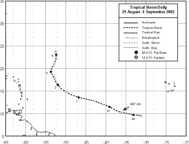
Figure 1:
Best track positions for Tropical Storm Dolly,
29 August - 4 September 2002.

Figure 2:
Selected wind observations and best track
maximum sustained surface wind speed curve for Tropical Storm
Dolly, 29 August- 4 September, 2002.
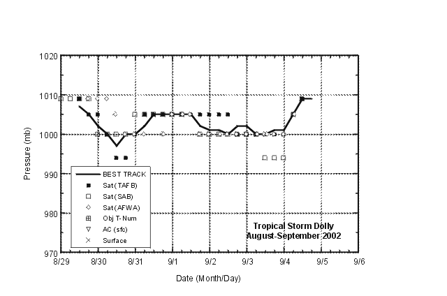
Figure 3:
Selected pressure observations and best
track minimum central pressure curve for Tropical Storm Dolly, 29
August- 4 September.
|


