Tropical Cyclone Report
Tropical Storm Arthur
14 - 16 July 2002
Miles B. Lawrence
National Hurricane Center
20 August 2002
Arthur was a tropical storm, with wind speeds up to 50 kt, that
moved east-northeastward across the western North Atlantic
Ocean.
a. Synoptic History
The origin of Arthur was a weak low-level circulation first
detected in the eastern Gulf of Mexico on July 9th. This
system was likely associated with a decaying frontal zone that had
persisted in the area for several days. The circulation and
associated low pressure meandered for a few days, then accelerated
northeastward across the southeastern U.S. on the 13th.
This was in response to a mid-level trough amplifying southward
along the U.S. east coast.
The circulation moved along the coast of South and North
Carolina on the 14th. By 1800 UTC of the
14th, the circulation and its associated convection were
well enough organized to become Tropical Depression One, centered
about 40 n mi west-southwest of Hatteras, North Carolina. The "best
track" of the tropical cyclone's path begins on the 14th
and is plotted in Figure 1. Figure 2 and Figure 3
are graphs of the wind
and pressure histories as a function of time. Best track positions
and intensities, every six hours, are listed in Table 1.
A mid-level low cut off from the westerlies and deepened as it
dropped southward over the Canadian Maritimes. The depression
responded by accelerating east-northeastward and slowly
strengthening. It became a tropical storm on the 15th
when its winds increased to 35 kt. By the time Arthur strengthened
to its estimated peak winds of 50 kt on the 16th, it was
centered about 350 n mi south of Nova Scotia and its forward speed
was increasing to 35 kt. Arthur turned northward late on the
16th around the above-mentioned low and became
extratropical as it moved northward over eastern Newfoundland.
Thereafter, the extratropical storm was tracked until the
19th as it slowed and became nearly stationary between
Newfoundland and Greenland and weakened below gale strength.
b. Meteorological Statistics
The best-track values of maximum 1-min, 10-m wind speeds, every
six hours, are plotted in Table 2, along with satellite-based
Dvorak technique wind speed estimates from the Tropical Analysis
and Forecast Branch (TAFB), the Satellite Analysis Branch (SAB) and
the U. S. Air Force Weather Agency (AFWA). Best-track minimum
central pressures are plotted in Table 3, along with Dvorak
technique pressure estimates. Selected ship and data buoy
observations are also plotted in Figure 2 and Figure 3.
In addition,
several non-rain-contaminated ocean surface wind speeds in the 45-
to 48-kt range were observed within Arthur's circulation by the
QuikSCAT scatterometer on the 15th and 16th.
A Canadian data buoy 44141 observed a pressure of 997.5 mb as the
center passed about 40 n mi to its south and also reported an 8-min
wind speed of 39 kt with a gust to 52 kt as the center passed. The
ship WESTON reported 44 kt on the
16th while located about 140 n mi south-southeast of the
center of Arthur. Ship reports of wind speeds of 34 knots or
greater are listed in Table 2.
Before Arthur became a tropical cyclone, its originating low
pressure system spread heavy rain across portions of north Florida,
Georgia and South Carolina on the 13th. Later, Arthur's
extratropical stage produced rainfall over Newfoundland on the
17th ranging up to about one inch. Wind speeds along
Newfoundland's east coast reached 34 kt at Bonavista on the
17th.
c. Casualty and Damage Statistics
There were no casualties or damage reported in association with
Arthur.
d. Forecast and Warning Critique
Arthur was a tropical storm for less than 48 hours. Average
official track forecast errors (number of cases in parentheses) for
Arthur are 80 (5), 138 (3), and 184 (1) nautical miles for the 12-,
24-, and 36-hour forecast periods, respectively. These errors are
considerably larger than the average official track errors for the
10-year period 1992-2001 of 43, 80, and 115 nautical miles. This is
due primarily to the large increase in forward speed which was not
correctly anticipated by the primary track guidance models nor by
the official forecast.
Average official intensity forecast errors were 4, 7, and 5
knots for the 12-, 24-, and 36-hour forecasts, respectively. For
comparison, the average official intensity forecast errors for the
10-year period 1992-2001 were 7, 11, and 14 knots.
Table 1: Best track for Tropical Storm Arthur, 14-16
July 2002.
Date/Time
(UTC) | Position | Pressure
(mb) | Wind Speed
(kt) | Stage |
Lat.
(°N) | Lon.
(°W) |
| 14 / 1800 | 34.3 | 76.8 | 1009 | 30 | tropical depression |
| 15 / 0000 | 35.0 | 75.1 | 1008 | 30 | " |
| 15 / 0600 | 35.5 | 73.3 | 1006 | 35 | tropical storm |
| 15 / 1200 | 36.1 | 71.0 | 1004 | 45 | " |
| 15 / 1800 | 36.8 | 68.2 | 1002 | 45 | " |
| 16 / 0000 | 37.9 | 65.1 | 1000 | 50 | " |
| 16 / 0600 | 38.6 | 61.7 | 998 | 50 | " |
| 16 / 1200 | 40.5 | 57.9 | 998 | 50 | " |
| 16 / 1800 | 42.5 | 54.5 | 997 | 50 | " |
| 17 / 0000 | 44.5 | 53.0 | 998 | 50 | extratropical |
| 17 / 0600 | 46.5 | 53.9 | 999 | 45 | " |
| 17 / 1200 | 48.0 | 54.0 | 1002 | 40 | " |
| 17 / 1800 | 49.0 | 53.0 | 1001 | 40 | " |
| 18 / 0000 | 50.5 | 52.5 | 999 | 40 | " |
| 18 / 0600 | 53.0 | 52.5 | 997 | 40 | " |
| 18 / 1200 | 55.5 | 53.0 | 995 | 35 | " |
| 18 / 1800 | 58.0 | 53.0 | 992 | 35 | " |
| 19 / 0000 | 57.0 | 52.0 | 996 | 35 | " |
| 19 / 0600 | 56.5 | 51.5 | 1000 | 35 | " |
| 19 / 1200 | 56.0 | 51.0 | 1005 | 35 | " |
| 16 / 1800 | 42.5 | 54.5 | 997 | 50 | minimum pressure |
Table 2: Selected ship reports with winds of at least 34 knots
for Tropical Storm Arthur, 14-16 July 2002.
| Ship Name or Call Sign | Date/Time (UTC) | Lat.
(°N) | Lon.
(°W) | Wind dir/speed (deg/kt) | Pressure (mb) |
| WESTON | 16/0000 | 35.7 | 64.1 | 200/44 | 1011.5 |
| MAESK SANTES | 16/0000 | 36.2 | 67.3 | 270/36 | 1011.0 |
| BETSY | 16/1800 | 39.8 | 53.2 | 220/37 | 1011.1 |
| P6038 | 17/0600 | 46.4 | 48.4 | 100/35 | 1017.0 |
| ALGOFAX | 17/1800 | 45.7 | 59.9 | xxx/41 | 1011.0 |
|
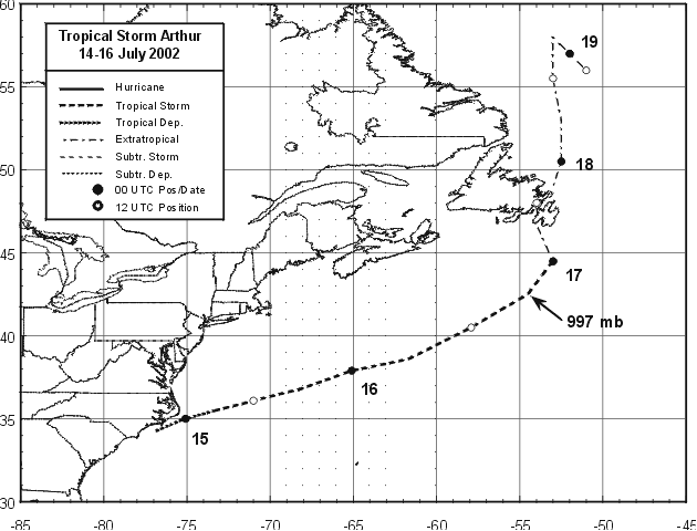
Figure 1:
Best track positions for Tropical Storm Arthur, 14-16
July 2002. Arthur's extratropical stage track positions for 16-19
July are also plotted.
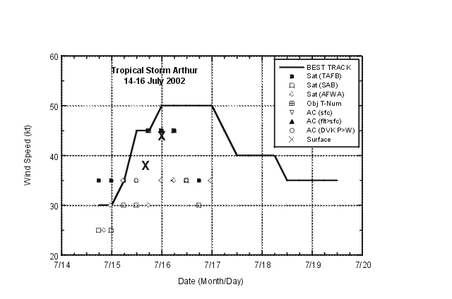
Figure 2:
Selected wind speed observations and estimates and best-track maximum
sustained surface wind speed curve for Tropical Storm Arthur, 14-16 July
2002. Arthur's extratropical stage best-track wind speeds for 16-19 July are
also plotted.
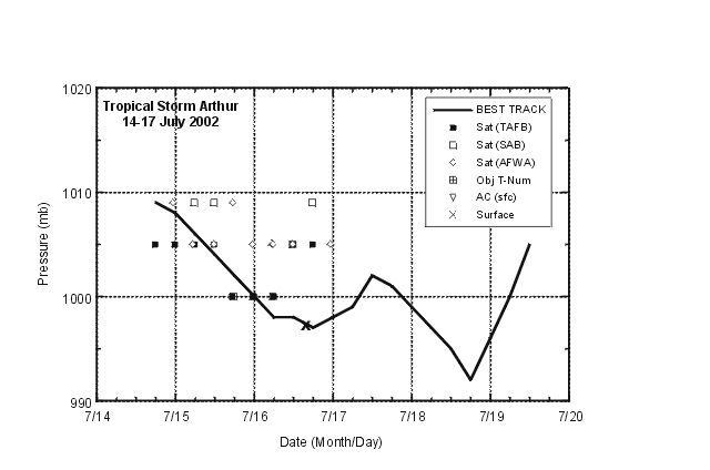
Figure 3:
Selected pressure observations and estimates and best
track minimum central pressure curve for Tropical Storm Arthur,
14-16 July 2002. Arthur's extratropical stage pressures for 16-19
July are also plotted.
|


