Tropical Cyclone Report
Tropical Storm Fay
5 - 11 September 2002
Stacy R. Stewart
National Hurricane Center
14 December 2002
Revised: 23 June 2003
Tropical Storm Fay was a short-lived cyclone that made landfall
along the central Texas producing widespread heavy rainfall and
inland flooding.
a. Synoptic History
Tropical Storm Fay developed from an area of disturbed weather
that included a broad, non-tropical low pressure system over the
northwestern Gulf of Mexico. During the first few days of
September, a broad mid- to upper-level trough moved southward from
the United States and became stationary across the northern Gulf of
Mexico. Thunderstorms developed along a surface low pressure trough
that hugged the northern Gulf of Mexico coastal areas. Gradually,
the trough and a series of weak low pressure systems drifted
southward over the warm waters (sea-surface temperatures
> 30° C) of the Gulf. A low in the northwestern
Gulf of Mexico became the dominant circulation and developed
persistent deep convection near the low-level center by 4
September. On 5 September, an Air Force Reserve Reconnaissance
aircraft investigated the system when it was centered about 85 n mi
southeast of Galveston, Texas. During the flight, a broad, closed
circulation and sufficient winds were found to estimate that a
tropical depression had formed at 1800 UTC. The "best track" chart
of the tropical cyclone's path is given in Figure 1, with the wind
and pressure histories shown in Figure 2 and Figure 3,
respectively. The
best track positions and intensities are listed in Table 1.
The depression moved steadily south-southwestward and
strengthened fairly quickly. The depression became Tropical Storm
Fay at 0000 UTC 6 September about 110 n mi southeast of Galveston.
Fay moved south-southwestward for 12 hours before turning toward
the west where it reached a peak intensity of 50 kt by 1200 UTC
that day about 125 n mi southeast of Galveston. Shortly thereafter,
Fay turned and moved erratically in a general west-northwestward
direction and maintained its 50 kt intensity for nearly 24 hours
until landfall occurred at 0900 UTC 7 September on the southern
Matagorda Peninsula about 10 n mi east of Port O'Connor, Texas.
After making landfall, the broad circulation reformed farther
north, about 25 n mi northwest of Palacios. Fay then made a sharp
turn toward the west and accelerated to about 15 kt. With more of
the circulation being over land, the faster forward speed hastened
the weakening process and by 0600 UTC 8 September, Fay had
degenerated into a remnant low pressure system about 30 n mi
southwest of Hondo, Texas. However, the rather tenacious remnant
low meandered across southern Texas and northeastern Mexico for
another 3 days producing copious amounts of rainfall before finally
dissipating about 65 n mi northwest of Monterrey, Mexico.
b. Meteorological Statistics
Observations in Fay (Figure 2 and Figure 3)
include satellite-based
Dvorak technique intensity estimates from the Tropical Analysis and
Forecast Branch (TAFB), the Satellite Analysis Branch (SAB) and the
U. S. Air Force Weather Agency (AFWA), as well as flight-level
observations from flights of the 53rd Weather
Reconnaissance Squadron of the U. S. Air Force Reserve Command.
There were no ship reports of tropical storm force winds
associated with Fay. Selected surface observations from land
stations and data buoys are given in Table 2.
Fay's peak intensity of 50 kt from 1200 UTC 6 September to 0900
UTC 7 September (near landfall) is based on a blend of a
reconnaissance flight-level spot wind report of 68 kt and larger
area of 60 kt wind, which convert to surface wind values of 54 kt
and 48 kt, respectively, and a pressure-wind relationship surface
wind estimate of approximately 43 kt (Figure 2).
This lower maximum
wind speed is believed to be more representative of Fay's overall
circulation since the isolated peak flight-level wind speed of 68
kt was well removed from the circulation center. In addition, after
the center of Fay moved inland, the converted
flight-level-to-surface wind speed estimate of 62 kt (Figure 2)
that was observed over land on 7 September was not considered to be
representative since it was associated with a large nocturnal
thunderstorm complex and little or no thunderstorm activity existed
over water. The minimum pressure of 998 mb at 0000 UTC 7 September
was based on a reconnaissance aircraft extrapolated surface
pressure from 1500 ft.
The 50 kt surface wind value at landfall along the central Texas
coast is consistent with previous flight-level-to surface wind
conversions when the center of Fay was still offshore and is close
to the pressure-wind relationship value of 47 kt. The interpolated
landfall minimum pressure of 999 mb is based on a reconnaissance
aircraft extrapolated (from 1500 ft) surface pressure of 999.9 mb
that was reported approximately 40 n mi northeast of the
center.
Maximum storm surge values were generally around 2 -3 ft all
along the Texas coast. Along the Louisiana coast, west of Cameron,
storm surge values ranged from 1.5 to 2.5 ft and caused minor beach
erosion and coastal highway flooding.
Rainfall totals across the San Antonio metropolitan area ranged
from 4 to 8 in with some isolated reports in excess of 11 in.
Across the remainder of south-central Texas, rainfall totals
exceeded 9 to 12 in at several locations (Figure 4),
with a total of 17.29 in reported at Fowlerton.
Twelve tornadoes occurred in association with Tropical Storm Fay. Six
of the tornadoes developed across the upper Texas coastal area on 6 and 7
September, while the remaining six tornadoes were reported over the coastal
plain of south-central Texas on 8 September. A funnel cloud was also
sighted 3 miles west of Belmont, Texas during the early evening of 6
September.
c. Casualty and Damage Statistics
While Fay was only a moderate tropical storm, a combination of
the long duration of tropical storm force winds and isolated
tornadoes resulted in damage to more than 800 single-family homes,
100 multi-family buildings, and nearly 100 businesses in Brazoria
County. Some coastal floods and beach erosion caused $3.5 million
in damage to public roads, bridges, and recreational areas along
the upper Texas coast, especially in Galveston County. Farther
south, though, only minor beach erosion occurred.
Heavy rainfall and widespread inland freshwater flooding
occurred across the upper Texas coastal area, north of where the
center of Fay passed. Rainfall totals across the Upper Texas coast
and in the Houston metropolitan area ranged from 8 to 12 in in many
areas, with some estimated rainfall totals of 20 to 24 in near the
town of Sweeney. Severe floods occurred across much of the upper
Texas coastal area. In Galveston County, 135 residential structures
were affected by Fay, with 23 receiving major damage that totaled
about $500,000 in losses. In Brazoria county, more than 1500 homes
and nearly 500 cars were flooded. In Matagorda County, 130
single-family homes and 32 businesses were damaged by flood waters.
In addition, over $1 million in damage was done to public
facilities, including roads, bridges, and public buildings. In
Wharton County, nearly 200 single-family homes were damaged or
destroyed by flood waters.
After moving inland and dissipating as a tropical cyclone, the
remnant low generated widespread showers and thunderstorms which,
in turn, produced torrential rainfall and widespread flooding
across the region. Some homes and businesses across the area were
damaged due to the floods. Ten homes were damaged due to floods in
La Coste in Medina County, while another 20 homes were damaged in
Pearsall in Frio County. Widepread minor damage also occurred to
roads and bridges across Bexar, Medina, Wilson, Atascosa, Frio,
Comal, and Guadeloupe Counties due to the floods. In contrast, the
remnants of Fay brought much needed rainfall to help alleviate
water shortage problems in the drought-stricken regions of
west-central and south Texas.
Several tornadoes were spawned by Fay before and after the system
moved inland. Late on 6 September, the first tornado destroyed a beach house
in Surfside; a second tornado damaged a home in Matagorda County near Van
Vleck. Shortly after midnight on 7 September, a third tornado hit west
Columbia knocking down numerous trees along Highway 36; the fourth tornado
touched down in Wharton County and destroyed a mobile home, and damaged 3
other mobile homes and a barn near Boling; the fifth and most significant
tornado (F1 intensity) touched down in extreme eastern Fort Bend County
destroying one mobile home and injuring 3 people; this same thunderstorm
later crossed the San Bernard River into Wharton County and produced a sixth
tornado that caused minor damage near Hungerford. During the morning and
early afternoon of 8 September, a total of 6 weak tornadoes (all F0)
occurred in Jim Wells (2 tornadoes), Bee, Live Oak, and Goliad (2 tornadoes)
Counties, but produced no damage.
No deaths were reported in association with Fay. Insured losses
did not meet the $25 million threshold in order to be recorded by
the American Insurance Services Group and total flood-related
damages are not available at this time. No monetary damage figures
are available from Mexico.
d. Forecast and Warning Critique
No meaningful track and wind forecast
statistics are available due to the limited period for which Fay
was a tropical storm. However, a tropical storm warning was issued
at 2100 UTC 5 September, which resulted in about 36 hours of lead
time.
Table 3 lists the watches and warnings
associated with Fay.
Acknowledgments
Some of the data in this report was furnished
by National Weather Service Offices in Brownsville, Corpus Christi,
Ft. Worth, Houston, San Angelo, and San Antonio, Texas, and Lake Charles,
Louisiana.
Table 1: Best track for Tropical Storm Fay, 5-11 September
2002.
Date/Time
(UTC) | Position | Pressure
(mb) | Wind Speed
(kt) | Stage |
Lat.
(°N) | Lon.
(°W) |
| 05 / 1800 | 28.0 | 93.8 | 1009 | 30 | tropical depression |
| 06 / 0000 | 27.8 | 93.9 | 1006 | 35 | tropical storm |
| 06 / 0600 | 27.6 | 94.1 | 1005 | 45 | " |
| 06 / 1200 | 27.7 | 94.5 | 1001 | 50 | " |
| 06 / 1800 | 27.8 | 94.7 | 999 | 50 | " |
| 07 / 0000 | 27.9 | 95.0 | 998 | 50 | " |
| 07 / 0600 | 28.1 | 95.6 | 999 | 50 | " |
| 07 / 1200 | 29.1 | 96.9 | 1002 | 30 | tropical depression |
| 07 / 1800 | 28.9 | 98.5 | 1002 | 25 | " |
| 08 / 0000 | 28.9 | 98.9 | 1003 | 20 | " |
| 08 / 0600 | 28.7 | 99.3 | 1007 | 15 | remnant low inland |
| 08 / 1200 | 29.0 | 99.5 | 1007 | 10 | " |
| 08 / 1800 | 28.9 | 99.1 | 1008 | 10 | " |
| 09 / 0000 | 28.5 | 99.2 | 1008 | 10 | " |
| 09 / 0600 | 28.3 | 99.2 | 1008 | 10 | " |
| 09 / 1200 | 28.1 | 99.4 | 1009 | 10 | " |
| 09 / 1800 | 27.8 | 99.6 | 1009 | 10 | " |
| 10 / 0000 | 27.4 | 99.5 | 1008 | 10 | " |
| 10 / 0600 | 27.0 | 99.3 | 1008 | 10 | " |
| 10 / 1200 | 26.8 | 99.8 | 1008 | 10 | " |
| 10 / 1800 | 26.6 | 100.4 | 1008 | 10 | " |
| 11 / 0000 | 26.5 | 101.0 | 1007 | 10 | " |
| 11 / 0600 | | | | | dissipated inland |
| 07 / 0900 | 28.5 | 96.3 | 999 | 50 | landfall just east of Port O'Connor, TX |
| 07 / 0000 | 27.9 | 95.0 | 998 | 50 | minimum pressure |
Table 2: Selected surface observations for Tropical Storm Fay,
5-11 September 2002.
| | Minimum
Sea-level
Pressure | Maximum Surface Wind Speed
(kt) | |
| Location | Date/
Time
(UTC) | Press.
(mb) | Date/
Timea
(UTC) | Sust.
Windb
(kts) | Peak
Gust (kts) | Storm
Surgec
(ft) | Storm
Tided
(ft) | Rain
(storm total)
(in) |
| Louisiana |
| Lafayette Arpt (KLFT) | 06/2329 | 1010.2 | 07/0156 | 14 | 17 | | | 0.03 |
| Lake Charles (KLCH) | 07/0321 | 1009.8 | 06/1604 | 24 | 29 | | | 0.31 |
| Texas |
| Angleton Arpt (KLBX) | 06/1811 | 1002.4 | 07/0008 | 28 | 37 | | | 4.43 |
| Angleton Courthouse | | | | | | | | 10.00 |
| Aransas Co. Arpt (KRKP) | 07/1059 | 1004.2 | 06/1851 | 23 | 28 | | | 2.16 |
| Austin (Bergstrom Arpt) | | | | | | | | 1.54 |
| Austin/(Georgetown Arpt) | | | | | | | | 3.53 |
| Austin/Great Hills | | | | | | | | 5.11 |
| Austin/Lake Georgetown | | | | | | | | 3.79 |
| Austin/Leander 5SW | | | | | | | | 4.94 |
| Bay City | | | | | | | | 6.39 |
| Bay City Coop | | | | | | | | 8.95 |
| Beaumont Arpt (KBPT) | 07/0035 | 1008.1 | 07/0215 | 21 | 26 | | | 0.32 |
| Bertram 3N (Burnet Co.) | | | | | | | | 5.58 |
| Boerne (Kendall Co.) | | | | | | | | 5.86 |
| Bulverde | | | | | | | | 2.93 |
| Brownsville WFO | | | | | | | | 0.38 |
| Camp Verde 3W | | | | | | | | 4.00 |
| Canyon Lake Dam | | | | | | | | 3.94 |
| Cheapside (Gonzales Co.) | | | | | | | |
3.93 |
| Clute (TECQ site) | | | 06/1945 | 42g | 62 | | | |
| Clute (TECQ site) | | | 06/2020 | | 72 | | | |
| Derby/Frio River | | | | | | | | 8.68 |
| Devine 6SSE | | | | | | | |
8.12 |
| Dilley (Frio Co.) | | | | | | | | 10.13 |
| E. Matagorda (TCOONf) | | | 07/0354 | 30 | 41 | | | |
| Elgin (Bastrop Co.) | | | | | | | | 4.35 |
| Evant | | | | | | | | 2.59 |
| Falcon Dam | | | | | | | | 4.31 |
| Folwerton Coop (FWTT2) | | | | | | | | 17.29 |
| Freeport Army COE | | | | | | | | 10.00 |
| Freeport Dow Chemical | | | | | | | | 10.27 |
| Freeport/Hwy 36 Bridge | | | 06/1943 | 41g | | | | 12.91 |
| Freeport RTNS(TCOONf) | | | 07/0354 | 50 | | | | |
| Freeport RTNS (TCOONf) | | | 07/0512 | 45 | 65 | | | |
| Galveston Arpt (KGLS) | 06/1307 | 1004.4 | 06/1923 | 33 | 40 | | |
4.09 |
| Galveston Causeway/I-45 | | | 06/2009 | 32g | 49 | | | 4.96 |
| Goliad 1SE Coop (GLIT2) | | | | | | | | 9.03 |
| Harlingen | | | | | | | | 3.28 |
| Hewitt | | | | | | | | 2.74 |
| Houston Hobby (KHOU) | 06/2011 | 1005.1 | 06/1946 | 25 | 32 | | | 1.25 |
| Houston IAP (KIAH) | 06/2314 | 1006.4 | 06/2221 | 23 | 26 | | | 3.37 |
| Karnes City 2N | | | | | | | | 6.92 |
| Kelly AFB (KSKF) | | | | | | | | 10.86 |
| La Grange/Colorado River | | | | | | | | 3.87 |
| Lane City | | | | | | | | 8.30 |
| Laredo Arpt (KLRD) | | | | | | | | 3.80 |
| Luling 12NE | | | | | | | | 3.46 |
| Jamaica Beach Coop | 06/1345 | 1004.4 | 06/2037 | 33 | 44 | | | 5.76 |
| Mason | | | | | | | | 2.11 |
| McAllen | | | | | | | | 3.28 |
| McGregor | | | | | | | | 2.20 |
| Mercedes | | | | | | | | 3.86 |
| New Braunfels 3ENE | | | | | | | | 3.22 |
| Galv. N. Jetty (TCOONf) | 07/0100 | 1004.0 | 07/0500 | 33 | | | | |
| Galv. N. Jetty (TCOONf) | 07/0600 | 1004.0 | 07/0600 | | 41 | | | |
| Galv. S. Jetty (TCOONf) | 07/0000 | 1003.4 | 06/1718 | 34 | | | | |
| Galv. N. Jetty (TCOONf) | | | 06/2245 | | 44 | | | |
| Palacios Arpt (KPSX) | 06/1959 | 999.7 | 06/1959 | 38 | 50 | | | |
| Pearsall 9E (Frio Co.) | | | | | | | | 12.00 |
| Pearsall (Frio Co.) | | | | | | | | 9.92 |
| Galv. Pleasure Pier (NOS) | 07/0100 | 1003.5 | 06/2248 | 39 | 45 | | | |
| Port Aransas | | | | | | 2.0 | | |
| Port O'Connor (TCOONf) | | | 07/0200 | | 35 | | | |
| Raymondville | | | | | | | |
6.03 |
| Refugio 2NW (GOIT2) | | | | | | | |
7.30 |
| Refugio 3SW (REFT2) | | | | | | | | 6.20 |
| Rio Grande City | | | | | | | | 6.03 |
| Round Rock | | | | | | | |
3.77 |
| Sabinal (Uvalde Co.) | | | | | | | | 6.79 |
| San Antonio Arpt (KSAT) | | | | | | | | 4.44 |
| San Antonio/Five Palms | | | | | | | | 11.09 |
| San Antonio/Loop 410 | | | | | | | | 6.67 |
| San Antonio/New Dawn | | | | | | | | 11.80 |
| San Saba | | | | | | | | 3.51 |
| Seguin 8S | | | | | | | |
6.53 |
| South Padre Island | | | | | | | | 2.91 |
| Taylor Ranch/San Saba | | | | | | | | 3.30 |
| Tow 10ESE (Llano co.) | | | | | | | | 6.23 |
| Yorktown | | | | | | | |
3.89 |
| Victoria Arpt (KVCT) | 07/0956 | 1001.7 | 06/1954 | 25 | 31 | | | |
| W. Galv. Bay (TCOONf) | 07/0700 | 1001.3 | 07/0518 | 42 | 55 | | | |
| Zapata | | | | | | | | 4.03 |
| NOAA National Data Buoy Center buoys |
| 42019 (27.9N 95.4W) | 07/0100 | 999.6 | 06/2000 | 36 | 45 | | | |
| 42035 (29.3N 94.4W) | 07/0000 | 1003.9 | 07/0300 | 33 | 41 | | | |
| NOAA National Data Buoy Center C-MAN stations |
| PTAT2 (27.8N
97.1W) | 07/0900 | 1004.3 | 08/1000 | 29e | 34 | | | |
| SRST2 (29.7N 94.1W) | 07/0000 | 1006.9 | 07/2110 | 29e | 38 | | | |
aDate/time is for wind gust when both sustained and gust are listed.
bExcept as noted, sustained wind averaging periods for C-MAN and land-based ASOS reports are
2 min; buoy averaging periods are 8 min.
cStorm surge is water height above normal astronomical tide level.
dStorm tide is water height above National Geodetic Vertical Datum (1929 mean sea level).
e10-min average.
fTCOON -- Texas Coastal Oceanic Observing Network,
Texas A&M Univ. Corpus Christi, TX
g5-min average. |
Table 3: Watch and warning summary for Tropical Storm Fay, 5-11
September 2002.
| Date/Time | Action | Location |
| 05 / 2100 | Tropical Storm Warning Issued | Matagorda, TX to Intracoastal City,
LA |
| 06 / 1500 | Tropical Storm Warning Extended | Matagorda, TX south to Port Aransas,
TX |
| 06 / 1500 | Tropical Storm Warning in Effect | Port Aransas to Intracoastal City |
| 06 / 1500 | Hurricane Watch Issued | Port O'Connor, TX to High Island, TX |
| 07 / 1200 | Hurricane Watch Discontinued | |
| 07 / 1500 | Tropical Storm Warning
Discontinued | |
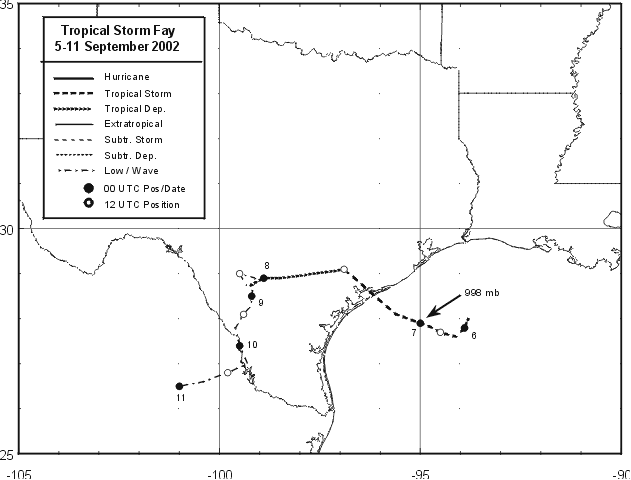
Figure 1:
Best track positions for Tropical Storm Fay, 5-11 September 2002, with
minimum central pressure.

Figure 2:
Selected wind observations and best track maximum sustained surface wind
speed curve for Tropical Storm Fay, 5-11 September 2002. Aircraft
observations have been adjusted for elevation using 75% and 80% reduction
factors for observations from 925 mb and 1500 ft, respectively.

Figure 3:
Selected pressure observations and best track minimum central
pressure curve for Tropical Storm Fay, 5-11 September 2002.
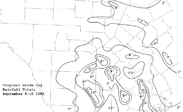
Figure 4:
South Texas rainfall totals 6-10 September 2002 associated with
Tropical Storm Fay and its remnant low pressure system (Map courtesy of WFO
San Antonio, TX).
|


