Tropical Cyclone Report
Tropical Depression Ten
7 - 9 September 2004
Richard J. Pasch
National Hurricane Center
21 November 2004
This depression originated from a tropical
wave that crossed the coast of Africa on 29 August. The wave was
accompanied by a well-organized area of disturbed weather that
passed just north of the Cape Verde Islands early on 30 August. The
disturbance moved westward over the eastern Atlantic for a couple
of days, and then turned northwestward, northward, and
northeastward while becoming less organized. However, on 7
September, a low-level circulation was evident, and although
southwesterly shear was displacing most of the thunderstorms from
the center, the deep convection was sufficiently close to the
center to qualify the system as a tropical depression by 1200 UTC
that day, while centered about 630 n mi southwest of the
westernmost Azores. The cyclone did not strengthen significantly,
since deep convection continued to be sheared northeastward from
the center. Early on 9 September, the depression's motion became
slow and erratic. Meanwhile, deep convection had become sheared far
enough away from the center to cause the system to degenerate to a
remnant low by 1200 UTC that day. The low turned southeastward and
east-southeastward, and dissipated around 1800 UTC 10 September,
about 230 miles west-southwest of the southernmost Azores. Table 1
lists the "best track" of this tropical cyclone, and
Figure 1 displays this best track.
Table 1: Best track for Tropical Depression
Ten, 7-9 September 2004.
Date/Time
(UTC) | Position | Pressure
(mb) | Wind Speed
(kt) | Stage |
Lat.
(°N) | Lon.
(°W) |
| 07 / 1200 | 31.5 | 39.7 | 1009 | 25 | tropical
depression |
| 07 / 1800 | 31.7 | 39.3 | 1009 | 25 | " |
| 08 / 0000 | 32.0 | 38.7 | 1010 | 25 | " |
| 08 / 0600 | 32.3 | 38.1 | 1011 | 25 | " |
| 08 / 1200 | 32.8 | 37.1 | 1012 | 25 | " |
| 08 / 1800 | 33.8 | 36.0 | 1012 | 25 | " |
| 09 / 0000 | 35.3 | 35.0 | 1012 | 30 | " |
| 09 / 0600 | 36.2 | 34.3 | 1013 | 30 | " |
| 09 / 1200 | 36.5 | 33.6 | 1013 | 30 | remnant low |
| 09 / 1800 | 36.0 | 33.4 | 1014 | 30 | " |
| 10 / 0000 | 35.7 | 32.3 | 1014 | 30 | " |
| 10 / 0600 | 35.5 | 31.0 | 1015 | 25 | " |
| 10 / 1200 | 35.3 | 29.5 | 1016 | 20 | " |
| 10 / 1800 | | | | | dissipated |
| 07 / 1200 | 31.5 | 39.7 | 1009 | 25 | minimum pressure |
| 09 / 0000 | 35.3 | 35.0 | 1012 | 30 | maximum intensity |
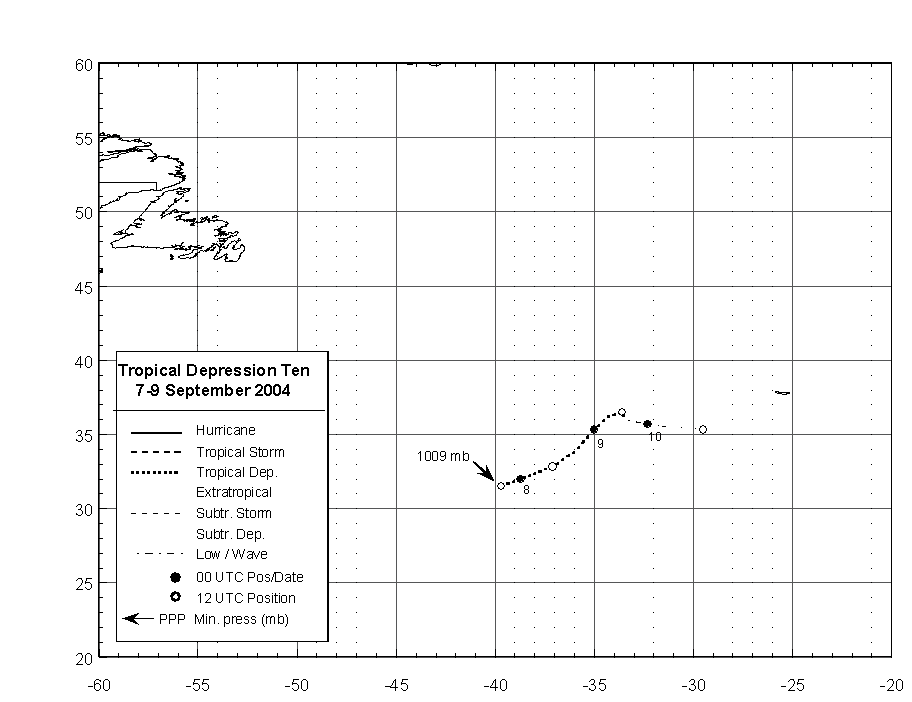
Figure 1:
Best track positions for Tropical
Depression Ten, 7-9 September 2004.
|


