Tropical Cyclone Report
Hurricane Lisa
19 September - 3 October 2004
Lisa was a long-lived tropical cyclone that
reached hurricane strength north of 40°N latitude.
a. Synoptic History
Lisa developed from a tropical wave that
crossed the African coast on 16 September. Early on 19 September
the wave showed enough organization to warrant a Dvorak
classification, and by 1800 UTC that day the system had developed
into a tropical depression, about 450 n mi west-southwest of the
Cape Verde Islands. The "best track" chart of the tropical
cyclone's path is given in Figure 1, with the wind and pressure
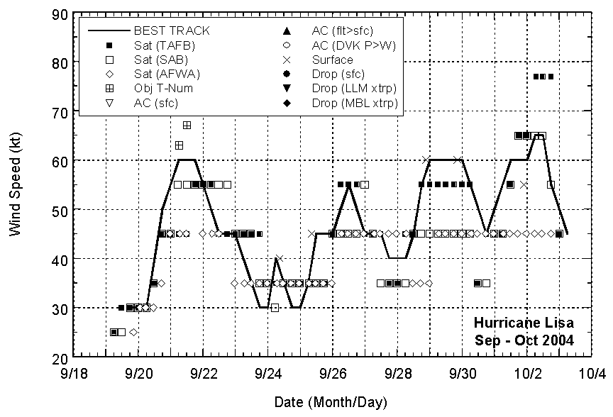
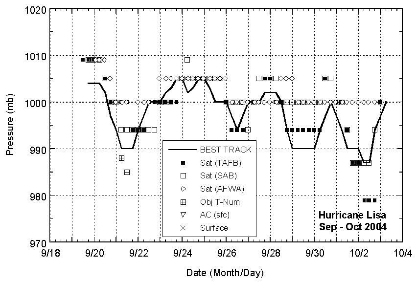
histories shown in Figure 2 and Figure 3,
respectively. The best track
positions and intensities are listed in Table 1.
The depression moved westward initially at
about 10 kt. The synoptic-scale environment was not particularly
favorable for development - the depression was located between
Hurricane Karl about 650 n mi to its west-northwest and a large and
convectively active tropical wave just a few hundred miles to its
southeast. Despite outflow from Hurricane Karl impinging on the
depression from the north, a small organized core developed and the
depression rapidly strengthened on 20 September, becoming a
tropical storm by 1200 UTC and reaching an estimated intensity of
60 kt 18 h later. The northerly shear prevailed, however, and Lisa
gradually weakened over the next couple of days. Meanwhile, the
wave disturbance was approaching Lisa from the east, and the two
systems began a Fujiwhara interaction. Lisa turned southward on 22
September and then eastward the next day as the convection from the
two systems became hard to distinguish. Although Lisa weakened to a
tropical depression on 23 September, it was able to maintain a
small but distinct low-level circulation throughout its merger with
the disturbance. Lisa completed its cyclonic loop early on 24
September and briefly re-attained tropical storm strength before
northerly shear again separated the cyclone from its deep
convection.
On 25 September Lisa turned sharply
northward ahead of a deep mid- to upper-level trough moving
southeastward into the central Atlantic. The northerly shear abated
and Lisa became a tropical storm for the third time at 0600 UTC,
about 925 miles east of the Lesser Antilles. Lisa moved northward
for five days as a tropical storm, nearly reaching hurricane
intensity on 29 September when an upper-level trough in the
westerlies cut off to the southwest of Lisa, reducing the
southwesterly shear over the storm. During this time satellite
imagery showed a ragged eye ringed by shallow convection. The
following day Lisa crossed some cooler water upwelled by
Hurricane Karl,
convection diminished, and the cyclone's winds dropped to 45
kt, even though the eye feature remained distinct.
On 1 October, Lisa turned northeastward and
accelerated ahead of an approaching short-wave trough in the
westerlies. Southwesterly shear diminished and Lisa re-strengthened
over 25°C waters. Early on 2 October, cloud
tops cooled significantly around the eye and Dvorak estimates
reached as high as 77 kt. Based on the satellite classifications,
it is estimated that Lisa became a hurricane, after 13 days of
existence as a tropical cyclone, at 0600 UTC 2 October, about 625 n
mi southeast of Cape Race, Newfoundland. At this time, water
temperatures under the cyclone were close to 23°C.
Lisa was a hurricane for less than 12 hours before
the cloud pattern began to deteriorate rapidly. Lisa lost tropical
characteristics by 0600 UTC 3 October, and was absorbed into a
frontal zone a few hours later, about 1000 n mi east-southeast of
Cape Race.
b. Meteorological Statistics
Observations in Lisa (Figure 2 and Figure 3)
include satellite-based Dvorak technique intensity estimates from
the Tropical Analysis and Forecast Branch (TAFB), the Satellite
Analysis Branch (SAB) and the U. S. Air Force Weather Agency
(AFWA), as well as microwave satellite imagery from NOAA
polar-orbiting satellites, the NASA Tropical Rainfall Measuring
Mission (TRMM), the NASA QuikSCAT, and Defense Meteorological
Satellite Program (DMSP) satellites.
Lisa's estimated maximum intensity of 65 kt
represents a blend of widely varying Dvorak intensity estimates on
2 October (Figure 2). As noted above, Lisa was over cool waters at
this time and it is unclear whether hurricane force winds actually
reached the surface. Operationally, Lisa was upgraded to a
hurricane at 2100 UTC 1 October. However, a QuikSCAT pass shortly
thereafter suggests that Lisa's winds were not as strong as
indicated by the satellite classifications at that time, and the
best track does not show Lisa becoming a hurricane until the
following day. Conversely, a careful examination of QuikSCAT passes
late on 28 and 29 August (Figure 2) suggests that during that period
Lisa was stronger than indicated by satellite techniques.
Ship reports of winds of tropical storm
force associated with Lisa are given in Table 2.
c. Casualty and Damage Statistics
There were no reports of damage or casualties associated with Lisa.
d. Forecast and Warning Critique
Average official track errors are given in Table 3.
Official errors for Lisa were very close to the average
official track errors for the 10-yr period 1994-2003[1].
The GFS model performed very
well for Lisa. Among the consensus models, GUNA provided better
guidance than either CONU or the FSU super-ensemble (FSSE).
Average official intensity errors were 7,
9, 13, 13, 14, 15, and 15 kt for the 12, 24, 36, 48, 72, 96, and
120 h forecasts, respectively. For comparison, the average official
intensity errors over the 10-yr period 1994-2003 are 6, 10, 12, 15,
19, 20, and 21 kt, respectively.
[1]Errors given
for the 96 and 120 h periods are averages over the three-year
period 2001-3.
Table 1: Best track for Hurricane Lisa, 19
Sept. - 3 Oct. 2004.
Date/Time
(UTC) | Position | Pressure
(mb) | Wind Speed
(kt) | Stage |
Lat.
(°N) | Lon.
(°W) |
| 19 / 1800 | 13.3 | 32.4 | 1004 | 30 | tropical depression |
| 20 / 0000 | 13.3 | 33.3 | 1004 | 30 | " |
| 20 / 0600 | 13.4 | 34.3 | 1004 | 30 | " |
| 20 / 1200 | 13.5 | 35.4 | 1002 | 40 | tropical
storm |
| 20 / 1800 | 13.7 | 36.4 | 997 | 50 | " |
| 21 / 0000 | 13.7 | 37.4 | 994 | 55 | " |
| 21 / 0600 | 13.9 | 38.3 | 990 | 60 | " |
| 21 / 1200 | 14.1 | 39.1 | 990 | 60 | " |
| 21 / 1800 | 14.3 | 39.7 | 990 | 60 | " |
| 22 / 0000 | 14.4 | 40.2 | 994 | 55 | " |
| 22 / 0600 | 14.4 | 40.6 | 997 | 50 | " |
| 22 / 1200 | 14.2 | 41.1 | 1000 | 45 | " |
| 22 / 1800 | 13.9 | 41.5 | 1000 | 45 | " |
| 23 / 0000 | 13.2 | 41.4 | 1000 | 45 | " |
| 23 / 0600 | 13.0 | 40.6 | 1002 | 40 | " |
| 23 / 1200 | 13.1 | 40.0 | 1003 | 35 | " |
| 23 / 1800 | 14.3 | 40.5 | 1005 | 30 | tropical depression |
| 24 / 0000 | 14.3 | 41.7 | 1005 | 30 | " |
| 24 / 0600 | 13.8 | 42.4 | 1002 | 40 | tropical storm |
| 24 / 1200 | 13.9 | 43.2 | 1003 | 35 | " |
| 24 / 1800 | 14.0 | 43.8 | 1005 | 30 | tropical depression |
| 25 / 0000 | 14.3 | 44.4 | 1005 | 30 | " |
| 25 / 0600 | 14.9 | 44.9 | 1003 | 35 | tropical
storm |
| 25 / 1200 | 15.7 | 45.4 | 1000 | 45 | " |
| 25 / 1800 | 16.7 | 45.7 | 1000 | 45 | " |
| 26 / 0000 | 17.4 | 45.8 | 1000 | 45 | " |
| 26 / 0600 | 18.0 | 45.9 | 997 | 50 | " |
| 26 / 1200 | 18.7 | 46.0 | 994 | 55 | " |
| 26 / 1800 | 19.2 | 46.0 | 997 | 50 | " |
| 27 / 0000 | 19.6 | 46.0 | 1000 | 45 | " |
| 27 / 0600 | 20.0 | 46.1 | 1000 | 45 | " |
| 27 / 1200 | 20.6 | 46.2 | 1000 | 45 | " |
| 27 / 1800 | 21.3 | 46.2 | 1002 | 40 | " |
| 28 / 0000 | 22.0 | 46.4 | 1002 | 40 | " |
| 28 / 0600 | 23.0 | 46.5 | 1002 | 40 | " |
| 28 / 1200 | 24.3 | 46.5 | 1000 | 45 | " |
| 28 / 1800 | 25.4 | 46.5 | 994 | 55 | " |
| 29 / 0000 | 26.4 | 46.4 | 990 | 60 | " |
| 29 / 0600 | 27.5 | 46.2 | 990 | 60 | " |
| 29 / 1200 | 28.9 | 45.8 | 990 | 60 | " |
| 29 / 1800 | 30.1 | 45.8 | 990 | 60 | " |
| 30 / 0000 | 31.1 | 46.1 | 990 | 60 | " |
| 30 / 0600 | 32.0 | 46.7 | 994 | 55 | " |
| 30 / 1200 | 32.4 | 47.3 | 997 | 50 | " |
| 30 / 1800 | 33.1 | 47.8 | 1000 | 45 | " |
| 01 / 0000 | 34.1 | 47.8 | 997 | 50 | " |
| 01 / 0600 | 35.1 | 47.6 | 994 | 55 | " |
| 01 / 1200 | 36.3 | 47.0 | 990 | 60 | " |
| 01 / 1800 | 37.7 | 45.8 | 990 | 60 | " |
| 02 / 0000 | 38.9 | 43.8 | 990 | 60 | " |
| 02 / 0600 | 40.3 | 41.6 | 987 | 65 | hurricane |
| 02 / 1200 | 41.6 | 39.1 | 987 | 65 | " |
| 02 / 1800 | 42.8 | 36.0 | 994 | 55 | tropical
storm |
| 03 / 0000 | 43.8 | 33.0 | 997 | 50 | " |
| 03 / 0600 | 44.5 | 30.0 | 1000 | 45 | extratropical |
| 03 / 1200 | | | | | absorbed into frontal zone |
| 02 / 0600 | 40.3 | 41.6 | 987 | 65 | minimum pressure |
Table 2: Selected marine reports with
winds of at least 34 kt for Hurricane Lisa, 19 Sept. - 3 Oct.
2004.
| Ship Name or Call Sign | Date/Time (UTC) | Lat.
(°N) | Lon.
(°W) | Wind dir/speed (deg/kt) | Pressure (mb) |
| 13602 | 26 / 2100 | 19.8 | 44.0 | 100 / 38 | 1010.1 |
| GQUK | 27 / 0900 | 20.4 | 42.9 | 130 / 35 | 1011.7 |
| 41595 | 28 / 0940 | 24.5 | 43.5 | / 43 | 1014.2 |
| ZCGH | 29 / 1200 | 28.3 | 46.6 | 320 / 47 | 1008.3 |
| ZCGH | 29 / 1800 | 28.5 | 44.8 | 260 / 41 | 1010.3 |
| WGMJ | 02 / 1300 | 45.9 | 45.1 | 040 / 35 | 1014.4 |
| WGMJ | 02 / 2100 | 47.1 | 42.3 | 050 / 40 | 1013.9 |
|
Table 3: Preliminary forecast evaluation
(heterogeneous sample) for Hurricane Lisa, 19 Sept. - 3 Oct. 2004.
Forecast errors (n mi) are followed by the number of forecasts in
parentheses. Errors smaller than the NHC official forecast are
shown in bold-face type. Verification includes the depression
stage, but does not include the extratropical stage.
| Forecast Technique | Period (hours) |
| 12 | 24 | 36 | 48 | 72 | 96 | 120 |
| CLP5 | 54 (52) | 107 (50) | 163 (48) | 214 (46) | 283 (42) | 399 (38) | 523 (34) |
| GFNI | 54 (51) | 93 (49) | 123 (47) | 152 (44) | 199 (35) | 235 (30) | 352 (26) |
| GFDI | 47 (51) | 85 (49) | 123 (47) | 165 (45) | 231 (41) | 246 (37) | 287 (33) |
| GFDL | 46 (51) | 82 (49) | 113 (47) | 151 (45) | 230 (41) | 257 (37) | 276 (33) |
| GFDN | 56 (51) | 95 (49) | 128 (47) | 149 (42) | 201 (34) | 229 (30) | 335 (25) |
| GFSI | 49 (48) | 76 (38) | 101 (36) | 125 (34) | 176 (28) | 186 (19) | 163 (11) |
| GFSO | 52 (47) | 85 (41) | 104 (35) | 124 (33) | 174 (28) | 194 (18) | 191 (12) |
| AEMI | 49 (51) | 80 (46) | 116 (44) | 149 (39) | 208 (31) | 244 (24) | 285 (19) |
| NGPI | 59 (51) | 105 (49) | 145 (47) | 180 (45) | 280 (40) | 363 (33) | 456 (28) |
| NGPS | 63 (52) | 109 (50) | 148 (48) | 184 (46) | 261 (40) | 320 (32) | 441 (29) |
| UKMI | 60 (47) | 106 (45) | 146 (43) | 216 (41) | 319 (35) | 478 (33) | 686 (27) |
| UKM | 61 (26) | 94 (24) | 125 (23) | 166 (22) | 266 (18) | 416 (18) | 617 (15) |
| A98E | 50 (52) | 95 (50) | 136 (48) | 183 (46) | 317 (42) | 424 (38) | 523 (34) |
| A9UK | 51 (26) | 94 (25) | 131 (24) | 172 (23) | 301 (21) | | |
| BAMD | 52 (52) | 91 (50) | 129 (48) | 166 (46) | 262 (42) | 343 (38) | 423 (34) |
| BAMM | 53 (51) | 90 (49) | 130 (47) | 174 (45) | 268 (41) | 325 (37) | 381 (33) |
| BAMS | 64 (52) | 118 (50) | 179 (48) | 247 (46) | 399 (42) | 548 (38) | 665 (34) |
| CONU | 47 (51) | 82 (49) | 108 (47) | 138 (45) | 198 (41) | 260 (37) | 354 (33) |
| GUNA | 48 (44) | 74 (37) | 93 (35) | 126 (33) | 174 (25) | 222 (17) | 388 (9) |
| FSSE | 44 (43) | 75 (41) | 109 (39) | 153 (36) | 215 (30) | 272 (22) | 412 (12) |
| OFCL | 44 (52) | 75 (50) | 99 (48) | 130 (44) | 199 (42) | 246 (38) | 325 (34) |
| NHC Official (1994-2003 mean) | 44 (3172) | 78 (2894) | 112 (2636) | 146 (2368) | 217 (1929) | 248 (421) | 319 (341) |
|
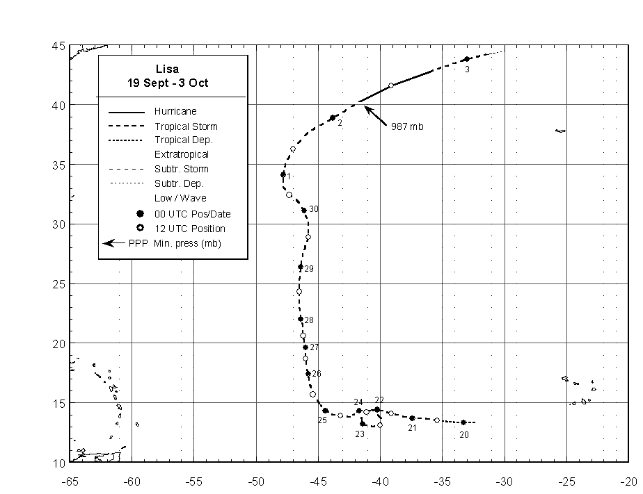
Figure 1:
Best track positions for Hurricane
Lisa, 19 Sept. - 3 Oct. 2004.

Figure 2:
Selected wind observations and best
track maximum sustained surface wind speed curve for Hurricane
Lisa, 19 Sept. - 3 Oct. 2004. Surface observations (denoted by X's)
represent QuikSCAT estimates of the maximum wind. Objective Dvorak
estimates represent linear averages over a three-hour period
centered on the nominal observation time.

Figure 3:
Selected pressure observations
and best track minimum central pressure curve for Hurricane Lisa,
19 Sept. - 3 Oct. 2004. Objective Dvorak estimates represent linear
averages over a three-hour period centered on the nominal
observation time.
|