Tropical Cyclone Report
Subtropical Storm Nicole
10 - 11 October 2004
Nicole was a short-lived subtropical storm
that passed near Bermuda.
a. Synoptic History
Nicole's genesis appears to be associated
with an upper-tropospheric trough and a decaying frontal system
that were over the southwestern North Atlantic during the first
week of October. There was also a persistent low-level trough
extending northward from the Lesser Antilles; analysis of satellite
images and surface data, however, suggest that the tropical trough
was a distinct feature unrelated to the development of this
subtropical cyclone. By 8 October, a broad area of surface low
pressure became evident about 400 n mi southeast of Bermuda, and
although it lacked a single, well-defined center of circulation,
this system began to produce gale force winds. These gales affected
Bermuda on 9 October. Around 0000 UTC 10 October, a better-defined
low-level circulation had formed about 140 n mi to the south of
Bermuda, with a band of clouds over the northern portion of the
circulation. This cloud band did not have much curvature, however.
Shortly thereafter, a distinctly curved cloud band developed over
the northwestern semicircle of the system, although there was no
deep convection over the center. Moreover, the strongest winds,
which were about 40 kt, were occurring more than 100 n mi from the
center. Based on the cloud pattern and wind field, it is estimated
that subtropical storm Nicole formed at 0600 UTC 10 October,
centered about 120 n mi to the southwest of Bermuda.
During 10 October, the cyclone's heading
turned from northwestward to northward, and then northeastward
heading due to the presence of a mid-tropospheric trough that was
moving off the northeast coast of the United States. Nicole's
center passed about 50 n mi to the northwest of Bermuda around 0000
UTC 11 October. Early on 11 October, some deep convection developed
closer to Nicole's center, suggesting that the system was trying to
acquire fully tropical characteristics. Deep convection failed to
wrap around the center, however, and strong upper-level
southwesterly flow sheared the deep convection away from the
center. The storm did not strengthen significantly while it
accelerated northeastward to north-northeastward, and it soon came
under the influence of a strong extratropical cyclone that was just
south of Nova Scotia. Nicole was absorbed by this cyclone shortly
after 1800 UTC 11 October.
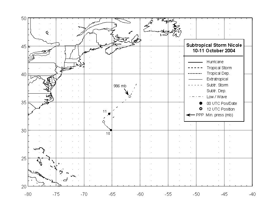
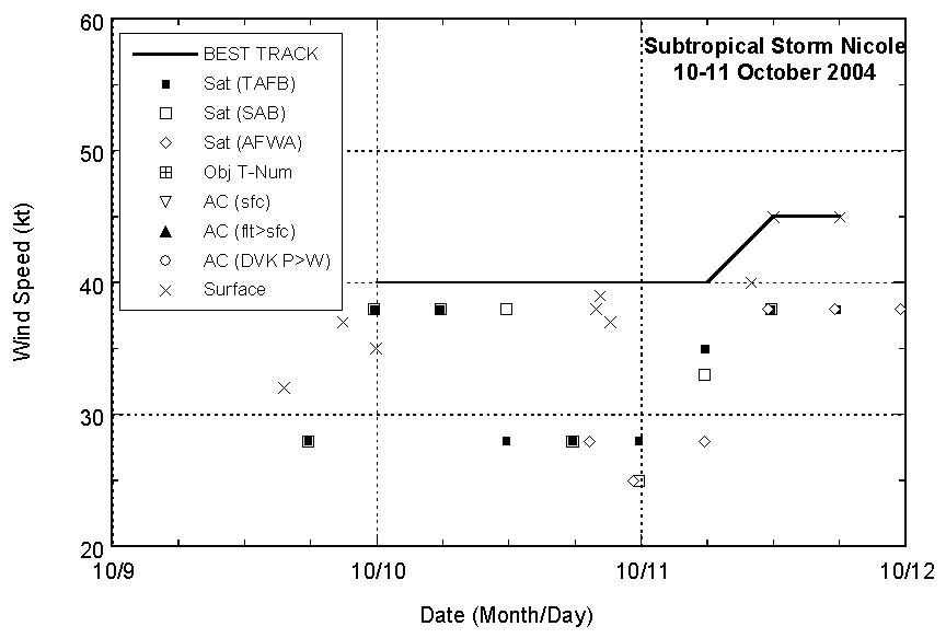
The "best track" chart of Nicole's path is
given in Figure 1, with the wind and pressure histories shown in
Figure 2 and Figure 3, respectively.
The best track positions and
intensities are listed in Table 1.
b. Meteorological Statistics
Observations in Nicole (Figure 2 and Figure 3)
include satellite-based Hebert-Poteat and Dvorak technique
intensity estimates from the Tropical Analysis and Forecast Branch,
the Satellite Analysis Branch, and the U. S. Air Force Weather
Agency, as well as surface observations from ships and Bermuda, and
NASA QuikSCAT data. Microwave data from NOAA polar-orbiting
satellites were also useful for monitoring the storm.
On 9 October, before Nicole formed, its
predecessor low pressure area caused gale force winds at Bermuda.
At 2055 UTC on that day, sustained winds of 37 kt with a gust to 52
kt were observed at the island. After Nicole's genesis, sustained
winds at Bermuda reached 39 kt with a gust to 48 kt at 2018 UTC 10
October.
Ship reports of 34 kt or greater winds
associated with Nicole are given in Table 2.
c. Casualty and Damage Statistics
There were no reported damages or
casualties associated with Nicole.
d. Forecast and Warning Critique
Since Nicole existed for less than 48
hours, there is no meaningful sample of forecasts to verify for
this cyclone. The few official forecasts that were issued had a
slightly left of track bias, and generally called for slightly more
strengthening than actually occurred.
The Bermuda Weather Service issued a gale
warning for Bermuda at 0230 UTC 9 October, which was more than a
day before Nicole formed. Additionally, they issued a tropical
storm watch for Bermuda at 0830 UTC 10 October. Both the gale
warning and the tropical storm watch were discontinued at 0830 UTC
11 October.
Table 1: Best track for subtropical storm
Nicole, 10-11 October 2004.
Date/Time
(UTC) | Position | Pressure
(mb) | Wind Speed
(kt) | Stage |
Lat.
(°N) | Lon.
(°W) |
| 10 / 0000 | 30.0 | 65.2 | 1000 | 40 | extratropical |
| 10 / 0600 | 31.0 | 66.3 | 1000 | 40 | subtropical
storm |
| 10 / 1200 | 31.5 | 66.5 | 1000 | 40 | " |
| 10 / 1800 | 32.1 | 66.5 | 998 | 40 | " |
| 11 / 0000 | 32.9 | 65.5 | 994 | 40 | " |
| 11 / 0600 | 34.3 | 63.9 | 992 | 40 | " |
| 11 / 1200 | 36.0 | 61.8 | 986 | 45 | " |
| 11 / 1800 | 38.5 | 60.5 | 986 | 45 | " |
| 12 / 0000 | | | | | absorbed |
| 11 / 1200 | 36.0 | 61.8 | 986 | 45 | minimum pressure |
Table 2: Selected ship and drifting buoy
reports with winds of at least 34 kt for Subtropical Storm Nicole,
10-11 October 2004.
| Ship Name or Call Sign | Date/Time (UTC) | Lat.
(°N) | Lon.
(°W) | Wind dir/speed (deg/kt) | Pressure (mb) |
| 41590 | 09 / 2200 | 26.5 | 59.2 | / 36 | 1013.1 |
| KSPH | 10 / 0600 | 33.3 | 68.1 | 360 / 38 | 1005.7 |
| KSPH | 10 / 0900 | 33.3 | 67.7 | 000 / 36 | 1002.5 |
| 41539 | 10 / 1700 | 25.6 | 69.0 | / 41 | 1012.6 |
| A8DM9 | 11 / 0300 | 33.3 | 67.7 | 320 / 39 | 1017.1 |
| WDB548 | 11 / 0600 | 38.1 | 69.6 | 290 / 43 | 1007.5 |
| KSDF | 11 / 1200 | 35.3 | 61.2 | 190 / 45 | |
| WDB548 | 11 / 1200 | 38.3 | 67.4 | 320 / 38 | 1003.5 |
| PFBE | 11 / 1800 | 39.4 | 57.1 | 170 / 35 | 998.0 |
| DNFA | 11 / 1800 | 40.9 | 55.9 | 150 / 43 | 1003.1 |
| 44141 | 12 / 0000 | 43.0 | 58.0 | 140 / 35 | 994.6 |
|

Figure 1:
Best track positions for Subtropical
Storm Nicole, 10-11 October 2004.

Figure 2:
Selected wind observations and
best track maximum sustained surface wind speed curve for
Subtropical Storm Nicole, 10-11 October
2004.
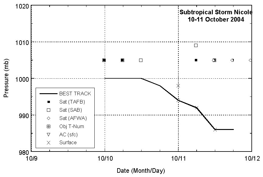
Figure 3:
Selected pressure observations
and best track minimum central pressure curve for
Subtropical Storm Nicole, 10-11 October
2004.
|