Tropical Cyclone Report
Tropical Storm Hermine
27 - 31 August 2004
Lixion A. Avila
National Hurricane Center
20 October 2004
Tropical Storm Hermine affected southeast
Massachusetts as a weakening tropical cyclone.
a. Synoptic History
Hermine developed from a nearly stationary
frontal zone over the subtropical Atlantic, the same frontal system
that spawned Tropical Storm Gaston. On 25 August, satellite imagery
showed that cloudiness and showers began to increase along the
frontal zone south of Bermuda. The activity became detached from
the front and began to show signs of cyclonic rotation at the
middle levels on 26 August. On the next day, visible satellite
images suggested that a weak surface circulation had developed and
is estimated that a tropical depression formed at 1800 UTC 27
August about 200 n mi south of Bermuda. The intensity of the
convection fluctuated during the following couple of days as the
depression moved toward the west-northwest, but the overall
organization increased. The system reach tropical storm status at
1200 UTC 29 August and reached its peak intensity of 50 knots and a
minimum pressure of 1002 mb at 0600 UTC 30 August. Hermine moved
northward and began to gradually weaken under strong northerly
shear caused by the outflow of
Tropical Storm Gaston located over
the eastern United States. The low-level center became detached
from the thunderstorm activity, and Hermine reached the southern
coast of Massachusetts near New Bedford as a 35-knot tropical storm
at 0600 UTC 31 August. Thereafter, it continued northward and
weakened rapidly while becoming extratropical. It became absorbed
by a frontal zone by 1800 UTC 31 August.
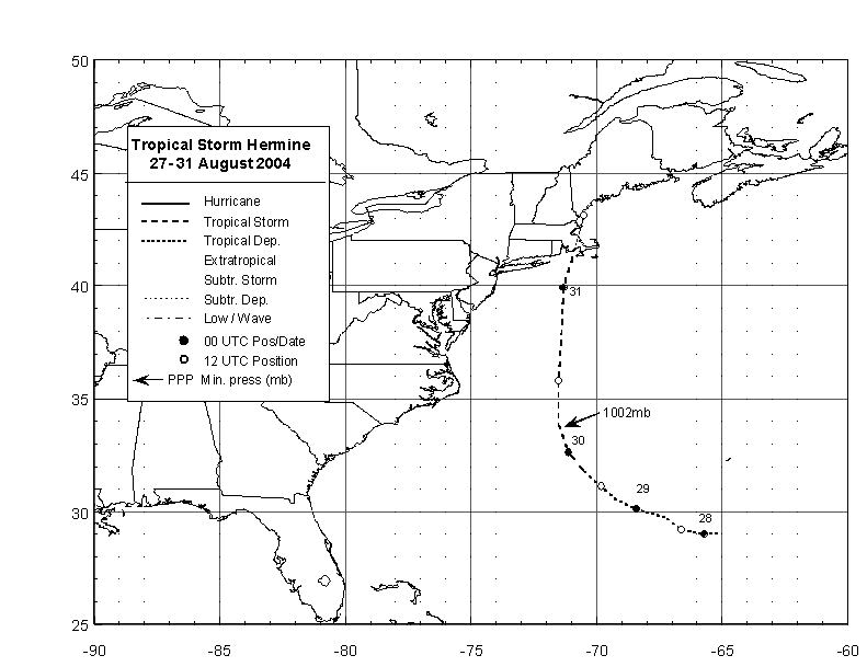
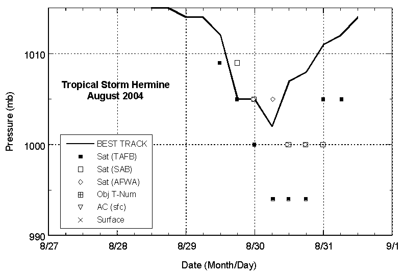
The "best track" chart of the tropical
cyclone's path is given in Figure 1, with the wind and pressure
histories shown in Figure 2 and Figure 3,
respectively. The best track
positions and intensities are listed in Table 1.
b. Meteorological Statistics
Observations in Hermine (Figure 2 and Figure 3)
include satellite-based Dvorak technique intensity estimates from
the Tropical Analysis and Forecast Branch (TAFB), the Satellite
Analysis Branch (SAB) and the U. S. Air Force Weather Agency
(AFWA). Microwave satellite imagery from NOAA polar-orbiting
satellites, the NASA Tropical Rainfall Measuring Mission (TRMM),
the NASA QuikSCAT, and Defense Meteorological Satellite Program
(DMSP) satellites were also useful in tracking Hermine. Based on
post-analysis of satellite images it is estimated that Hermine's
genesis occurred two days earlier than analyzed operationally. The
peak intensity, which occurred at 0600 UTC on the 30 August, was
based on a later QuikSCAT pass at 0947 UTC showing 45 to 50 knots
to the southeast of the center.
Hermine developed within a high pressure
environment. Therefore, pressures in the best track are a higher
than the usual pressures obtained from applying the Dvorak
technique pressure-wind relationship.
Hermine brought a few bands of heavy rains
and wind gusts to tropical storm force over eastern Massachusetts,
but no tropical storm force sustained winds were measured in the
area. Rainfall over Cape Cod and the adjacent islands was mostly
less than 0.5 inches. However, rainbands from Tropical Storm Gaston
began to spread over the area shortly after Hermine moved off Cape
Cod. This made it difficult to separate the rainfall amounts
between these two cyclones.
c. Casualty and Damage Statistics
There were no reports of damage or
casualties associated with Hermine.
d. Forecast and Warning Critique
Hermine was a short-lived tropical cyclone
and there were just a few official forecasts to verify.
Neverthereless, the average official track errors (with the number
of cases in parentheses) for Hermine were 32(5), 110(3), and 158
(1) n mi for the 12, 24, 36 h forecasts, respectively. With the
exception of the 12 h forecast, these errors are larger than the
average official track errors for the 10-yr period 1994-2003 of 44,
78, and 112 n mi, respectively.
Average official intensity errors were 3, 5
and 10 kt for the 12, 24, and 36 h forecasts, respectively. For
comparison, the average official intensity errors over the 10-yr
period 1994-2003 are 6, 10, and 12 kt, respectively.
A tropical storm warning was issued for
southeastern Massachusetts from Wood Hole to Plymouth, including
Martha's Vineyard and Nantucket, at 1700 UTC 30 August. The warning
was discontinued at 0900 UTC 31 August.
Table 1: Best track for Hermine, 27-31 August, 2004.
Date/Time
(UTC) | Position | Pressure
(mb) | Wind Speed
(kt) | Stage |
Lat.
(°N) | Lon.
(°W) |
| 27 / 1800 | 29.0 | 65.2 | 1016 | 25 | tropical depression |
| 28 / 0000 | 29.0 | 65.7 | 1016 | 25 | " |
| 28 / 0600 | 29.1 | 66.2 | 1016 | 25 | " |
| 28 / 1200 | 29.2 | 66.6 | 1015 | 30 | " |
| 28 / 1800 | 29.7 | 67.2 | 1015 | 30 | tropical
depression |
| 29 / 0000 | 30.1 | 68.4 | 1014 | 30 | " |
| 29 / 0600 | 30.5 | 69.2 | 1014 | 30 | " |
| 29 / 1200 | 31.1 | 69.8 | 1012 | 35 | tropical
storm |
| 29 / 1800 | 31.8 | 70.5 | 1005 | 40 | " |
| 30 / 0000 | 32.6 | 71.1 | 1005 | 40 | " |
| 30 / 0600 | 33.8 | 71.5 | 1002 | 50 | " |
| 30 / 1200 | 35.8 | 71.5 | 1007 | 45 | " |
| 30 / 1800 | 37.6 | 71.4 | 1008 | 45 | " |
| 31 / 0000 | 39.9 | 71.3 | 1010 | 35 | " |
| 31 / 0600 | 41.5 | 70.9 | 1011 | 35 | " |
| 31 / 1200 | 43.1 | 70.5 | 1014 | 25 | extratropical |
| 31/ 1800 | | | | | Absorbed by a cold front |
| 31/ 0600 | 41.5 | 70.9 | 1011 | 35 | Landfall near New Bedford, Mass. |
| 30 / 0600 | 33.8 | 71.5 | 1002 | 50 | minimum pressure |

Figure 1:
Best track positions for Hermine, 27-31 August, 2004.
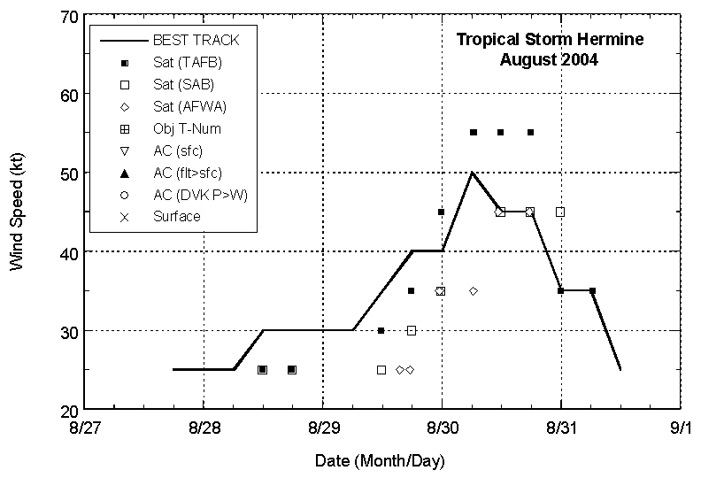
Figure 2:
Selected wind observations and
best track maximum sustained surface wind speed curve for Hermine,
27-31 August, 2004.

Figure 3:
Selected pressure observations
and best track minimum central pressure curve for Hermine, 27-31
August, 2004.
|