Tropical Cyclone Report
Hurricane Alex
31 July - 6 August 2004
James L. Franklin
National Hurricane Center
26 October 2004
Alex brought category 1 hurricane
conditions to the North Carolina Outer Banks as its center passed
just offshore, and later strengthened to a category 3 hurricane
while near 38°N latitude. Only one other
hurricane (Ellen of 1973) reached major hurricane status farther
north than Alex.
a. Synoptic History
Three distinct weather systems may have
played a role in the genesis of Alex. On 26 July, shower activity
increased several hundred miles to the east of the northwestern
Bahamas. This activity was associated with a weak surface trough,
likely of mid-latitude origin. Disorganized showers persisted just
to the east of the Bahamas, in the diffluent region to the east of
an upper-level low, for the next couple of days. On 28 July, when a
tropical wave reached the area, the extent and organization of the
convection began to increase. Analyses show that a broad area of
surface low pressure formed early on 30 July just northeast of the
central Bahamas. The low moved northwestward and over the next 36
hours the circulation slowly became better defined. By 1800 UTC 31
July, when the low center was located about 175 n mi east of
Jacksonville, the system had enough convective organization to be
classified as a tropical depression.
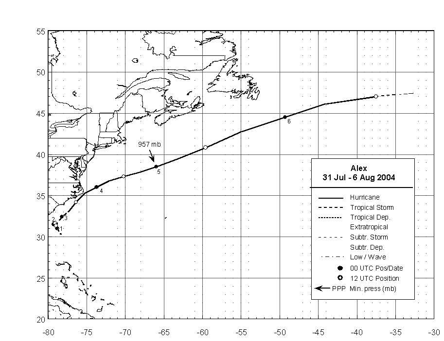
The "best track" chart of the tropical
cyclone's path is given in Figure 1, with the wind and pressure
histories shown in Figure 2 and Figure 3,
respectively. The best track
positions and intensities are listed in Table 1. As the depression
approached a break in the subtropical ridge early on 1 August, its
forward motion slowed, and the cyclone remained nearly stationary
for the next day or so about 115 n mi east-southeast of Savannah.
The depression remained poorly organized initially, due to
northeasterly shear and an environment characterized by subsidence
and dry air. However, an upper-level trough was approaching from
the west, and in advance of this trough the northeasterly flow over
the cyclone began to relax. During this transition the depression
was able to strengthen, and it became a tropical storm at 1800 UTC
1 August.
Alex began to move northeastward early on 2
August, taking a track that would slowly approach the coastline of
the Carolinas over the next 36 hours. The northeasterly shear
continued to diminish during the day as upper-level southwesterlies
approached. The deep convection, which had previously been confined
to the southwest quadrant of the circulation, was now able to
organize in bands to the east of the center. Alex strengthened,
becoming a hurricane near 0600 UTC 3 August, when it was centered
about 65 n mi south-southeast of Cape Fear.
Aided by warm Gulf Stream waters and light
shear, Alex continued to strengthen on 3 August as it neared the
North Carolina Outer Banks. The hurricane's maximum sustained winds
reached 85 kt (category 2 on the Saffir-Simpson Hurricane Scale) at
1200 UTC, and the minimum pressure fell to 972 mb at 1800 UTC. Alex
made its closest approach to land near 1700 UTC, with its center
located about 9 n mi southeast of Cape Hatteras, while the western
eyewall of the hurricane raked the Outer Banks with sustained
Category 1 hurricane force winds.
After passing the Outer Banks, Alex turned
away from land and accelerated as it became embedded in a deep
layer of west-southwesterly flow. Alex strengthened and became a
major hurricane (Category 3) at 0000 UTC 5 August, with winds of
105 kt and a minimum pressure of 957 mb. At this time Alex was at
38.5° N (385 n mi south-southwest of
Halifax, Nova Scotia), moving east-northeastward at 20-25 kt, and
over waters just above 26°C - not factors
normally associated with major hurricanes. Only Hurricane Ellen of
1973 attained major hurricane status farther north. While the basic
environmental current surrounding Alex was low in shear, the cause
of this unexpected strengthening remains unknown.
By late on 5 August Alex had moved north of
the Gulf Stream over sub-20°C waters and
was weakening rapidly. Moving at 40-45 kt, Alex weakened to a
tropical storm after 0600 UTC 6 August and became extratropical a
few hours later about 830 n mi east of Cape Race Newfoundland. The
circulation of Alex was absorbed into a larger extratropical low by
0000 UTC 7 August.
b. Meteorological Statistics
Observations in Alex (Figure 2 and Figure 3)
include satellite-based Dvorak technique intensity estimates from
the Tropical Analysis and Forecast Branch (TAFB), the Satellite
Analysis Branch (SAB) and the U. S. Air Force Weather Agency
(AFWA), as well as flight-level and dropwindsonde observations from
flights of the 53rd Weather Reconnaissance Squadron of
the U. S. Air Force Reserve Command. Other data sources include
microwave satellite imagery from NOAA polar-orbiting satellites,
the NASA Tropical Rainfall Measuring Mission (TRMM), the NASA
QuikSCAT, and Defense Meteorological Satellite Program (DMSP)
satellites. Ship reports of winds of tropical storm force
associated with Alex are given in Table 2, and selected surface
observations from land stations and data buoys are given in
Table 3
Alex reached its estimated maximum
intensity after all reconnaissance flights had ended; the peak wind
estimate of 105 kt is based on a blend of objective and subjective
Dvorak numbers. At the time of closest approach to land, Alex's
maximum sustained winds are estimated to be 85 kt, based largely on
dropsonde surface observations of 77 and 87 kt. The highest
observed flight-level wind was 105 kt. This would normally
correspond to a surface wind of about 95 kt, but a lower value has
been used here because this observation occurred in a
non-convective portion of the circulation.
Although the center of Alex remained
offshore (and therefore Alex technically did not make landfall),
the western portion of the eyewall passed over the North Carolina
Outer Banks on 3 August. There was a relatively high density of
surface observations in the area for this event, and these
observations generally indicate that category 1 sustained winds
were experienced in the Outer Banks. The highest gust accepted as
accurate was an unofficial report from a storm chaser of 91 kt in
Hatteras Village at 1814 UTC, with a maximum sustained wind report
of 67 kt at about the same time. A five-minute mean wind of 65 kt
was reported from a 10-m anemometer at Avon Pier. An unofficial
gust report of 104 kt at the Ocracoke Ferry office is believed to
be in error, based on nearby storm-chaser observations as well as
the nature of the damage.
The highest estimated surge values, near 6
ft, occurred on the sound (west) side of the Outer Banks at Buxton
and Ocracoke Village. Flooding of this magnitude had not occurred
on Ocracoke Island since Hurricane Gloria in 1985. Waters rose to
2-4 ft above normal levels along the lower reaches of the Neuse and
Pamlico rivers.
The highest measured rainfall amount
associated with Alex, 7.55 in, occurred at Ocracoke, with 5.62 in
reported in Beaufort. Doppler radar data indicated a large area of
4-8 in accumulations across extreme southeastern Craven county,
eastern Carteret county northeastward across Hyde and Dare
counties.
c. Casualty and Damage Statistics
A 26 year-old male was drowned in strong
waves and residual rip currents off of Nags Head, North Carolina,
two days after the passage of Alex.
Storm surge damage and beach erosion was
significant in Dare and Hyde counties on the Outer Banks.
Significant wind and water damage occurred from Buxton southward
and across Ocracoke Island, where hundreds of vehicles and homes
were flooded from sound-side surge. Hurricane force winds produced
minor structural damage to homes and businesses and caused
extensive damage to trees and power lines.
There was insufficient wind damage
associated with Alex to meet the $25 million reporting level
threshold of the American Insurance Services Group. Insured damage
from flooding is estimated to be about $2 million. The total damage
from Alex is estimated to be not more than $5 million.
d. Forecast and Warning Critique
The disturbance that ultimately developed
into Alex was first mentioned in the Atlantic Tropical Weather
Outlook on 27 July, 4 days prior to genesis. Outlooks began
indicating the possibility of tropical cyclogenesis 2 days in
advance.
Average official track errors (OFCL) are
given in Table 4. OFCL errors for Alex were generally close to the
average official track errors for the 10-yr period
1994-2003[1]. Through 48 h, a number of models
had lower errors than the official forecast, including GFSI, BAMD,
and the consensus models GUNA and FSSE. Official forecasts were
generally better than the objective guidance beyond 48 h.
Average official intensity errors were 10,
14, 20, 28, 40, 43, and 43 kt for the 12, 24, 36, 48, 72, 96, and
120 h forecasts, respectively, considerably above the long-term
mean errors of 6, 10, 12, 15, 19, 20, and 21 kt, respectively. The
initial strengthening to 85 kt near Cape Hatteras was
under-forecast by about 40 kt from 36 h out and beyond, although it
was correctly noted in Tropical Cyclone Discussions that there
would be an opportunity for strengthening once the northeasterly
shear abated. The intensification to major hurricane status at the
northern latitudes was not anticipated.
Table 5 lists the watches and warnings
associated with Alex. A hurricane warning was issued at 2100 UTC 2
August, roughly 20 hours prior to the onset of hurricane force
winds on the Outer Banks - somewhat less lead time than is
desirable. The initial warning for the Outer Banks, issued at 1500
UTC 1 August, was a tropical storm warning. At this time all the
objective intensity guidance, as well as the official forecast,
called for Alex to remain below hurricane strength. Strengthening
to a hurricane was first forecast in the advisory issued at 1500
UTC 2 August, but it was felt at that time that hurricane force
winds would remain offshore.
Acknowledgments
NWS/WFOs in Newport, Wilmington,
Charleston, and Wakefield contributed many of the observations
contained in this report. The highest winds observations over land
were provided by Mark Sudduth and Weatherflow, Inc.
[1]Errors given
for the 96 and 120 h periods are averages over the three-year
period 2001-3.
Table 1: Best track for Hurricane Alex, 31
July - 6 August.
Date/Time
(UTC) | Position | Pressure
(mb) | Wind Speed
(kt) | Stage |
Lat.
(°N) | Lon.
(°W) |
| 31 / 1800 | 30.3 | 78.3 | 1010 | 25 | tropical
depression |
| 01 / 0000 | 31.0 | 78.8 | 1009 | 25 | " |
| 01 / 0600 | 31.5 | 79.0 | 1009 | 25 | " |
| 01 / 1200 | 31.6 | 79.1 | 1009 | 30 | " |
| 01 / 1800 | 31.6 | 79.2 | 1009 | 35 | tropical
storm |
| 02 / 0000 | 31.5 | 79.3 | 1007 | 35 | " |
| 02 / 0600 | 31.4 | 79.4 | 1005 | 40 | " |
| 02 / 1200 | 31.3 | 79.0 | 992 | 50 | " |
| 02 / 1800 | 31.8 | 78.7 | 993 | 50 | " |
| 03 / 0000 | 32.4 | 78.2 | 987 | 60 | " |
| 03 / 0600 | 33.0 | 77.4 | 983 | 70 | hurricane |
| 03 / 1200 | 34.2 | 76.4 | 974 | 85 | " |
| 03 / 1800 | 35.3 | 75.2 | 972 | 85 | " |
| 04 / 0000 | 36.0 | 73.7 | 974 | 80 | " |
| 04 / 0600 | 36.8 | 72.1 | 973 | 80 | " |
| 04 / 1200 | 37.3 | 70.2 | 973 | 85 | " |
| 04 / 1800 | 37.8 | 68.3 | 965 | 95 | " |
| 05 / 0000 | 38.5 | 66.0 | 957 | 105 | " |
| 05 / 0600 | 39.5 | 63.1 | 957 | 105 | " |
| 05 / 1200 | 40.8 | 59.6 | 962 | 100 | " |
| 05 / 1800 | 42.7 | 55.0 | 970 | 90 | " |
| 06 / 0000 | 44.5 | 49.3 | 978 | 75 | " |
| 06 / 0600 | 46.1 | 44.2 | 984 | 65 | " |
| 06 / 1200 | 47.0 | 37.5 | 987 | 50 | tropical
storm |
| 06 / 1800 | 47.4 | 32.7 | 992 | 30 | extratropical |
| 07 / 0000 | | | | | absorbed |
| 05 / 0000 | 38.5 | 66.0 | 957 | 105 | minimum pressure |
Table 2: Selected ship and drifting buoy
reports with winds of at least 34 kt for Hurricane Alex, 31 July -
6 August.
| Ship Name or Call Sign | Date/Time (UTC) | Lat.
(°N) | Lon.
(°W) | Wind dir/speed (deg/kt) | Pressure (mb) |
| 30408 | 02 / 1200 | 32.5 | 78.7 | 010 / 37 | 1003.0 |
| 30408 | 03 / 0000 | 32.5 | 78.7 | 010 / 37 | 1003.0 |
| C6JT | 04 / 0000 | 33.0 | 72.3 | 180 / 50 | 1010.0 |
| WAUY | 04 / 1500 | 35.9 | 67.3 | 260 / 35 | 1006.0 |
| WAUY | 04 / 1800 | 36.0 | 67.9 | 240 / 40 | 1004.1 |
| WAUY | 04 / 2100 | 36.4 | 68.3 | 240 / 40 | 1003.5 |
| WAUY | 05 / 0000 | 36.8 | 68.8 | 280 / 35 | 1005.0 |
| VRWF2 | 05 / 1200 | 35.7 | 59.9 | 220 / 36 | 1012.6 |
| KHRH | 05 / 1500 | 39.3 | 55.9 | 210 / 40 | 1015.8 |
| KHRH | 05 / 1800 | 39.3 | 56.5 | 230 / 35 | 1007.1 |
| 4XFC | 05 / 1800 | 39.7 | 48.3 | 200 / 37 | 1014.0 |
| P3ZY6 | 05 / 2100 | 37.7 | 56.5 | 230 / 35 | 1011.0 |
| ELYD5 | 06 / 1200 | 43.0 | 42.3 | 240 / 40 | 1010.5 |
|
Table 3: Selected surface observations for
Hurricane Alex, 31 July - 6 August.
| | Minimum
Sea-level
Pressure | Maximum Surface Wind Speed
(kt) | |
| Location | Date/
Time
(UTC) | Press.
(mb) | Date/
Timea
(UTC) | Sust.
Windb
(kts) | Peak
Gust (kts) | Storm
Surgec
(ft) | Storm
Tided
(ft) | Rain
(storm total)
(in) |
| North Carolina |
| Wilmington (ILM) | 03/0932 | 1003.7 | 03/1001 | 18 | 26 | | | |
| Cape Hatteras (HSE) | 03/1551 | 991.2g | 03/1623 | 38g | 53 | | | |
| Beaufort (MRH) | 03/1356 | 999.2 | 03/1336 | 35 | 46 | | | 5.62 |
| Ocracoke | | | | | | | | 7.55 |
| Newport | | | | | | | | 2.88 |
| Buxton | | | | | | 6 | | |
| Ocracoke Village | | | | | | 6 | | |
| N.C. (Unofficial) |
| Wrightsville Bch. Pier | | | 03/? | | 34 | | | |
| Hatteras Village | 03/1810 | 981 | 03/1814 | 67 | 91 | | | |
| Avon | | | 03/1715 | | 76g | | | |
| Avon Pier | | | 03/1735 | 65f | 78 | | | |
| Avon (Sound) | | | 03/1900 | 64f | 80 | | | |
| Kure Beach | | | 03/0900 | | 34 | | | |
| Bald Head Island | | | 03/? | | 37 | | | |
| Buoys and CMAN sites |
| 41025 | 03/1600 | 990.7g | 03/1600 | 47g | 62 | | | |
| 41013 | 03/0750 | 994.9 | 03/0710 | 35 | 45 | | | |
| CLKN7
(Cape Lookout) | 03/1300 | 994.7 | 03/1400 | 51 | 56 | | | |
| FPSN7 (Frying Pan Shls) | 03/1300 | 994.8 | 03/0900 | 33 | 45 | | | |
| DUCN7 (Duck) | 03/2100 | 1002.7 | 03/1900 | 39 | 43 | | 5.12h | |
| 44140 | 05/2200 | 979.3 | | | | | | |
aDate/time is for sustained wind when both sustained and
gust are listed.
bExcept as noted, sustained
wind averaging periods for C-MAN and land-based ASOS reports are 2
min; buoy averaging periods are 8 min.
cStorm surge is water height
above normal astronomical tide level.
dStorm tide is water height
above National Geodetic Vertical Datum (1929 mean sea level).
e2 min average
f5 min average
gRecord incomplete due to instrument failure.
hWater height above mean lower low water. |
Table 4: Preliminary forecast evaluation
(heterogeneous sample) for Hurricane Alex, 31 July - 6 August.
Forecast errors (n mi) are followed by the number of forecasts in
parentheses. Errors smaller than the NHC official forecast are
shown in bold-face type. Verification includes the depression
stage, but does not include the extratropical stage.
| Forecast Technique | Period (hours) |
| 12 | 24 | 36 | 48 | 72 | 96 | 120 |
| CLP5 | 60 (22) | 144 (20) | 238 (18) | 305 (16) | 505 (12) | 740 (8) | 817 (4) |
| GFNI | 62 (19) | 101 (17) | 138 (15) | 209 (13) | 338 (6) | 254 (1) | |
| GFDI | 44 (22) | 80 (20) | 127 (18) | 180 (16) | 339 (10) | 215 (1) | |
| LBAR | 45 (22) | 97 (20) | 144 (18) | 163 (16) | 254 (11) | 376 (8) | 178 (3) |
| FSSE | 34 (18) | 45 (16) | 75 (14) | 138 (12) | 331 (7) | 266 (1) | |
| GFSI | 34 (21) | 58 (19) | 88 (17) | 142 (15) | 349 (11) | 286 (7) | 543 (1) |
| AEMI | 37 (22) | 61 (20) | 89 (18) | 143 (16) | 353 (12) | 470 (8) | 586 (3) |
| BAMD | 42 (22) | 68 (20) | 88 (18) | 121 (16) | 246 (12) | 366 (8) | 512 (4) |
| BAMM | 58 (22) | 99 (20) | 143 (18) | 203 (16) | 352 (12) | 293 (8) | 233 (4) |
| BAMS | 87 (22) | 160 (20) | 232 (18) | 306 (16) | 507 (12) | 615 (8) | 1009 (4) |
| NGPI | 57 (22) | 98 (20) | 118 (18) | 155 (16) | 381 (12) | 590 (8) | 715 (4) |
| UKMI | 45 (18) | 69 (18) | 91 (16) | 187 (14) | 390 (10) | 915 (6) | 612 (2) |
| A98E | 45 (22) | 97 (20) | 150 (18) | 173 (16) | 359 (12) | 659 (8) | 537 (4) |
| A9UK | 49 (11) | 95 (10) | 146 (9) | 174 (8) | 343 (6) | | |
| CONU | 46 (22) | 78 (20) | 109 (18) | 159 (16) | 339 (11) | 499 (7) | 645 (3) |
| GUNA | 34 (18) | 64 (18) | 87 (16) | 140 (14) | 353 (9) | 540 (1) | |
| OFCL | 44 (22) | 74 (20) | 104 (18) | 163 (16) | 257 (12) | 260 (8) | 222 (2) |
| NHC Official (1994-2003 mean) | 44 (3172) | 78 (2894) | 112 (2636) | 146 (2368) | 217 (1929) | 248 (421) | 319 (341) |
|
Table 5: Watch and warning summary for
Hurricane Alex, 31 July - 6 August.
| Date/Time | Action | Location |
| 31 / 2100 | Tropical Storm Watch issued | Edisto Beach to Cape Hatteras |
| 1 / 1500 | Tropical Storm Watch modified to | Edisto Beach to Cape Fear |
| 1 / 1500 | Tropical Storm Warning issued | Cape Fear to Cape Hatteras |
| 1 / 2100 | Tropical Storm Watch modified to | Edisto Beach to South Santee River |
| 1 / 2100 | Tropical Storm Watch issued | Cape Hatteras to Oregon
Inlet |
| 1 / 2100 | Tropical Storm Warning modified to | South Santee River to Cape Hatteras |
| 2 / 1500 | Tropical Storm Watch discontinued | All |
| 2 / 1500 | Tropical Storm Warning modified to | South Santee River to Oregon Inlet |
| 2 / 2100 | Tropical Storm Warning modified to | Oregon Inlet to NC/VA border |
| 2 / 2100 | Hurricane Warning issued | Cape Lookout to Oregon Inlet |
| 3 / 0900 | Tropical Storm Warning modified to | Cape Fear to Cape Lookout |
| 3 / 1500 | Tropical Storm Warning modified to | Surf City to Cape Lookout |
| 3 / 2100 | Tropical Storm Warning discontinued | Surf City to Cape Lookout |
| 4 / 0000 | Tropical Storm Warning discontinued | All |
| 4 / 0000 | Hurricane Warning discontinued | All |

Figure 1:
Best track positions for
Hurricane Alex, 31 July - 6 August.
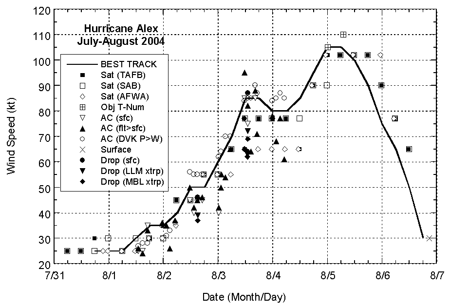
Figure 2:
Selected wind observations and
best track maximum sustained surface wind speed curve for Hurricane
Alex, 31 July - 6 August. Aircraft observations have been adjusted
for elevation using 90%, 80%, and 80% reduction factors for
observations from 700 mb, 850 mb, and 1500 ft, respectively.
Dropwindsonde observations include actual 10 m winds (sfc), as well
as surface estimates derived from the mean wind over the lowest 150
m of the wind sounding (LLM), and from the sounding boundary layer
mean (MBL). Objective Dvorak estimates represent linear averages
over a three-hour period centered on the nominal observation
time.
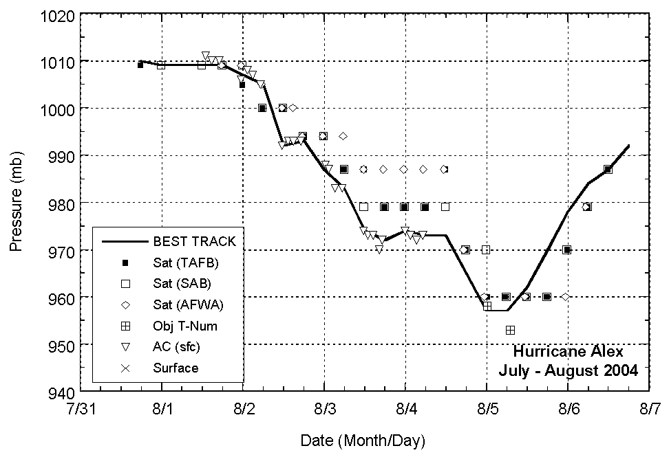
Figure 3:
Selected pressure observations
and best track minimum central pressure curve for Hurricane Alex,
31 July - 6 August. Objective Dvorak estimates represent linear
averages over a three-hour period centered on the nominal
observation time.
|