

 NCDC / Climate Monitoring / Climate of 2004 / October / Help NCDC / Climate Monitoring / Climate of 2004 / October / Help
|
| Climate of 2004 October in Historical Perspective National Climatic Data Center
|
Contents of this Report:Major HighlightsGlobal AnalysisGlobal Hazards and Significant EventsNational OverviewUnited States DroughtU.S. Pre-instrumental PerspectiveU.S. Climate Extremes |
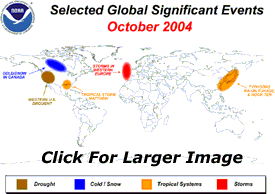 |

Major HighlightsNOAA REPORTS DRY CONDITIONS RETURN IN THE EAST, RECORD WET IN PARTS OF THE WEST. ABOVE AVERAGE TEMPERATURES IN THE SOUTH.October was the eighth wettest on record averaged across the contiguous United States, with wetter than average conditions across much of the nation, except the east coast. After a record or near record wet September for most states along the eastern seaboard due to rainfall from multiple tropical systems, October was drier than average for many of those same states. Louisville, Kentucky had its longest dry stretch (39 days) on record. In contrast, record wet conditions were widespread across parts of the far West. Nevada had its wettest October on record and California it's second wettest. The first major Pacific storm of the season came ashore in California on October 19th.The weather station at the Santa Ana fire station received 3.15 inches of rain on October 20th, more rain in one day than the previous October monthly record of 1.89 inches set in 1957. Rainfall amounts of one to four inches were common along much of California's coastline and also into the Sierra Nevada Mountains where the precipitation fell as snow. A second large storm during the last week of October brought more rain and snow to California allowing ski-slopes to open early in parts of the Sierra Nevada. Wet conditions during October, resulting in part from Tropical Storm Matthew, also prevailed in the Mississippi Valley following a dry September. Snowfall disrupted travel in Colorado and parts of the Rockies in October with areas of the Front Range receiving over a foot of snow on October 31st/November 1st. Over two inches of snow was recorded in Denver and approximately four inches in Boulder. The precipitation in the West helped alleviate drought conditions that have persisted for six years in some locations. However, the recent rain and snow will not eliminate the long-term drought in the region. At the end of October, 18.4 percent of the western U. S. was in moderate-to-extreme drought, compared with 59.3 percent for September and 80.1 percent for last year at this time, based on a widely used measure of drought, the Palmer Drought Index. NOAA scientists report that the average temperature for the contiguous United States for October (based on preliminary data) was 56.3°F (13.5°C), which was 1.5°F (0.8°C) above the 1895-2003 mean, and the 16th warmest October on record. The mean temperature in 18 states was significantly above average, with an additional seven southern states averaging much warmer than the long-term mean, including Louisiana, which had its third warmest October since at least 1895. Alaska, which experienced a record warm summer, was again warmer than average in October with a statewide temperature of 5.5°F (3.1°C) above the 1971-2000 mean. The average global temperature anomaly for combined land and ocean surfaces during October 2004 (based on preliminary data) was 1.15°F (0.64°C) above the 1880-2003 long-term mean. This was the second warmest September since 1880 (the beginning of reliable instrumental records). Land surface temperatures ranked record warm for October and were anomalously warm throughout much of the globe, with notably cooler-than-average conditions in central Canada and northeastern Russia, while the global ocean surface temperature was the third warmest on record for October. |
|
Report Index
|
|
|