|
Use these links to access detailed analyses of Global and U.S. data. 
|


  |
Sea-Surface Temperatures (SSTs) and
Mixed-Layer Conditions:
SST anomalies remained above normal in December across the central equatorial Pacific, although there was a slight increase in the monthly averaged Ni�o 3.4 index. Above average ocean temperatures were also observed in the mixed-layer, with the largest temperature anomalies reaching 3�C at approximately 100 m depth near 120�W. In addition, the depth of the 20�C isotherm increased in December. In the central equatorial Pacific, above normal SST anomalies remained during December, which were reflected in the monthly averaged SST anomalies in the Ni�o 3.4 Index. The western Pacific SST anomaly warmed slightly in December, as observed in the Ni�o 4 Index (map of Ni�o regions). For the most recent ocean surface temperature conditions, please see the loop of satellite-derived weekly SST anomalies for December 2004. Above average SST anomalies across the equatorial Pacific have persisted over the past several months, and this can be seen in the data from NCDC's Extended Reconstructed Sea Surface Temperature dataset (ERSST version 2). For December, the Ni�o 3.4 Index decreased slightly to +0.81�C (+1.46�F) above normal, and the 3-month running mean of the Ni�o 3.4 Index was well above +0.5�C. (NOTE: A running 3-month mean SST anomaly above +0.5�C in the Ni�o 3.4 region is one indicator that an El Ni�o is occurring. For the official NOAA classification scheme, please see NOAA's El Ni�o/La Ni�a Index Definition and see the CPC ENSO Diagnostic Discussion for their latest official assessment of ENSO conditions.) |
  |
Equatorial Zonal Winds (U-Component Winds) and Sea-Level Topography:
The easterly trade winds were below normal across much of the western equatorial Pacific basin during December, with westerly zonal wind anomalies developing the western Pacific during the month. The anomalous westerly flow during the month weakened equatorial upwelling, which led to a slight increase in the monthly averaged SST anomaly across the western equatorial Pacific region. Despite the below average zonal wind field from Indonesia eastward past the dateline to 150�W, moderate trade wind flow and above average easterly zonal wind anomalies were present from the central Pacific to the South American coast. Satellite altimetry of ocean surface topography from the NASA/JPL Jason-1 satellite over the Pacific basin and global oceans is shown to the left. Anomalous westerly wind activity in December appears to have generated another oceanic Kelvin wave in the mixed-layer that propogated eastward during the month. The most recent Pacific overpass of the Jason-1 satellite shows the sea level rise associated with this Kelvin wave in the central equatorial Pacific at the end of December (see both the 12 December 2004 and 27 December 2004 overpasses). |


|
Outgoing Longwave Radiation (OLR):
The map to the left shows the spatial pattern of global OLR (in W m-2) observed by satellite in December. In general, the majority of the equatorial Pacific region had near-normal OLR and only small departures from the 1979-1995 base period during December. The 3-month averaged OLR anomalies were also near-normal or slightly positive along the equator from the dateline to the South American coast. The monthly averaged OLR Index value switched signs again in December, resulting in a monthly index value of +0.5 averaged across the region centered over the dateline in the western Pacific between 160� E and 160� W. The shift in sign of the OLR Index from a negative value in November to a positive one in December reflected the lack of persistence in the OLR Index this past year, during which the index shifted several times between positive and negative values. Therefore, the convective response of the atmosphere to the above average SST anomalies in the western and central equatorial Pacific has been limited, since the OLR Index has shown no consistent trend throughout all of 2004. Note that high frequency variability in OLR is typically associated with the Madden-Julian Oscillation (MJO) (MJO related convective activity propagates west to east in the near-equatorial region from the Indian Ocean into the Pacific Ocean approximately every 30-60 days). The latest MJO activity can be seen in CPC's graphs of Daily MJO Indices. |
 |
Southern Oscillation Index (SOI): The standardized SOI remained negative for the seventh consecutive month in December, with an average index value of -0.9 for the month. Negative SOI values are consistent with ENSO warm event (i.e. El Ni�o) conditions. The trend in SOI during the past six months has fluctuated several times between a near-neutral value and a more negative index associated with warm event conditions, which suggests that the atmosphere has lagged behind the ocean in response to the above average SSTs during the past few months. Therefore, El Ni�o conditions in the equatorial Pacific remained weak at the end of the year. |
 NOVEMBER
SST anomaly exceeds 0.5 �C for 5th consecutive month in Ni�o 3.4 region
  |
Sea-Surface Temperatures (SSTs) and
Mixed-Layer Conditions:
SST anomalies remained above normal in November across the central equatorial Pacific, which led to a slight increase in the monthly averaged Ni�o 3.4 index. Above average ocean temperatures were also observed in the mixed-layer, with the largest temperature anomalies reaching 3�C at approximately 100 m depth between 160�W and 140�W. In addition, the depth of the 20�C isotherm increased in November. In the central equatorial Pacific, above normal SST anomalies also increased during November, which were reflected in the monthly averaged SST anomalies in the Ni�o 3.4 index. The western Pacific SST anomaly cooled slightly in November, as reflected in the Ni�o 4 index (map of Ni�o regions). For the most recent ocean surface temperature conditions, please see the loop of satellite-derived weekly SST anomalies for November. The SSTs across the equatorial Pacific have increased over the past several months, and this can be seen in the data from NCDC's Extended Reconstructed Sea Surface Temperature dataset (ERSST version 2). For November, the Ni�o 3.4 index increased slightly to +0.89�C (+1.6�F) above normal, and the 3-month running mean of the Ni�o 3.4 index was well above +0.5�C. (NOTE: A running 3-month mean SST anomaly above +0.5�C in the Ni�o 3.4 region is one indicator that an El Ni�o is occurring. For the official NOAA classification scheme, please see NOAA's El Ni�o/La Ni�a Index Definition and see the CPC ENSO Diagnostic Discussion for their latest official assessment of ENSO conditions.) |
  |
Equatorial Zonal Winds (U-Component Winds) and Sea-Level Topography:
The easterly trade winds were below normal across much of the western equatorial Pacific basin during November. The below normal easterly flow during the month weakened equatorial upwelling, which led to a slight increase in the monthly averaged SST anomaly across the central equatorial Pacific region. Despite the below average zonal wind field from Indonesia eastward past the dateline, moderate trade wind flow and above average easterly zonal wind anomalies were present from the central Pacific to the South American coast. Satellite altimetry of ocean surface topography from the NASA/JPL Jason-1 satellite over the Pacific basin and global oceans is shown to the left. Increases in sea-level, shown on these images as positive sea-level anomalies, developed in the western equatorial Pacific in October and were associated with an oceanic Kelvin wave, which subsequently propagated eastward during November. However, the most recent overpass shows that the sea level rise associated with this Kelvin wave has decreased, which suggests that it began to dissipate as it moved into the eastern equatorial Pacific and toward the South American coast (see both the 15 November 2004 and 27 November 2004 overpasses). |


|
Outgoing Longwave Radiation (OLR):
The map to the left shows the spatial pattern of global OLR (in W m-2) observed by satellite in November. The above average OLR anomalies in the western Pacific west of the dateline reflected areas of enhanced tropical convection, while areas east of the dateline along the equator were near-normal. In general, the majority of the equatorial Pacific region had near-normal OLR and small departures from normal during November. The only exception was an area of negative OLR anomalies in the northwest Pacific associated with tropical cyclone activity. The 3-month averaged OLR anomalies were also near-normal along the equator from the dateline to the South American coast. The monthly averaged OLR Index value for November was -0.2 across the region centered over the dateline in the western Pacific between 160� E and 160� W. Therefore, the convective response of the atmosphere to the warm SST anomalies in the western and central equatorial Pacific has been limited, since the OLR Index remains near-neutral (although slightly negative). In fact, there has been no persistent trend in the OLR Index, which has shifted signs several times in 2004. High frequency variability in OLR is typically associated with the Madden-Julian Oscillation (MJO) (MJO related convective activity propagates west to east in the near-equatorial region from the Indian Ocean into the Pacific Ocean approximately every 30-60 days). The latest MJO activity can be seen in CPC's graphs of Daily MJO Indices. |
 |
Southern Oscillation Index (SOI): The standardized SOI remained negative for the sixth consecutive month in November, with an average index value of -0.9 for the month. Negative SOI values are consistent with ENSO warm event (i.e. El Ni�o) conditions. The trend in SOI during the past six months has fluctuated several times between a near-neutral value and a more negative index associated with warm event conditions, which suggests that the atmosphere has lagged behind the ocean in response to the above average SSTs during the past few months. Therefore, El Ni�o conditions in the equatorial Pacific remained weak to moderate at the end of November. |
OCTOBER
  |
Sea-Surface Temperatures (SSTs) and
Mixed-Layer Conditions:
SST anomalies continued to increase in October across the equatorial Pacific, which led to an increase in the monthly averaged Ni�o indices. Above average ocean temperatures were also observed in the mixed-layer, with the largest temperature anomalies east of 140�W. In addition, the depth of the 20�C isotherm increased in October. In the central and western equatorial Pacific, above normal SST anomalies also increased during October, which were reflected in the monthly averaged SST anomalies in both the Ni�o 3.4 and Ni�o 4 indices (map of Ni�o regions). For the most recent ocean surface temperature conditions, please see the loop of satellite-derived weekly SST anomalies for October. The SSTs across the equatorial Pacific have increased over the past several months, and this can be seen in the data from NCDC's Extended Reconstructed Sea Surface Temperature dataset (ERSST version 2). For October, the Ni�o 3.4 index increased to +0.87�C (+1.57�F) above normal, and the 3-month running mean of the Ni�o 3.4 index was well above +0.5�C. (NOTE: A running 3-month mean SST anomaly above +0.5�C in the Ni�o 3.4 region is one indicator that an El Ni�o is occurring. For the official NOAA classification scheme, please see NOAA's El Ni�o/La Ni�a Index Definition and see the CPC ENSO Diagnostic Discussion for their latest official assessment of ENSO conditions.) |
  |
Equatorial Zonal Winds (U-Component Winds) and Sea-Level Topography:
The easterly trade winds were below normal across much of the western equatorial Pacific basin during October. The below normal easterly flow during the month weakened equatorial upwelling, which led to an increase in the average SSTs across the entire equatorial Pacific basin. Despite the below average zonal wind field from Indonesia eastward past the dateline, moderate trade wind flow and above average easterly zonal wind anomalies were present from the central Pacific to the South American coast. Satellite altimetry of ocean surface topography from the NASA/JPL Jason-1 satellite over the Pacific basin and global oceans is shown to the left. Increases in sea-level, shown on these images as positive sea-level anomalies, developed in the western equatorial Pacific in early October, and subsequently propagated eastward. This suggests the development of a Kelvin wave in the mixed layer (see the most recent altimetry measurements over the Pacific Ocean from the 31 October 2004 overpass). |


|
Outgoing Longwave Radiation (OLR):
The monthly averaged OLR Index value for October was zero (i.e. neutral) across the region centered over the dateline in the western Pacific between 160� E and 160� W. Since the beginning of 2004 there has been no persistent trend in the OLR Index, which has shifted signs several times. The map to the left shows the spatial pattern of global OLR observed by satellite in October. The above average OLR anomalies in the western Pacific over Indonesia reflected areas of suppressed tropical convection, while the below average OLR anomalies northwest of Australia were associated with enhanced convection along the South Pacific Convergence Zone (SPCZ). In general, most of the equatorial Pacific region had near-normal OLR and small departures from normal during October. High frequency variability in OLR is typically associated with the Madden-Julian Oscillation (MJO) (MJO related convective activity propagates west to east in the near-equatorial region from the Indian Ocean into the Pacific Ocean approximately every 30-60 days). The latest MJO activity can be seen in CPC's graphs of Daily MJO Indices. |
 |
Southern Oscillation Index (SOI): The standardized SOI remained negative for the fifth consecutive month in October, with an average index value of -0.3 for the month. Negative SOI values are consistent with ENSO warm event (i.e. El Ni�o) conditions. However, the trend in SOI during the past five months has been toward a neutral value, as the index increased from -1.3 in June to -0.3 in October, suggesting that the atmosphere has lagged significantly behind the ocean during the past few months. Therefore, El Ni�o conditions in the equatorial Pacific remain relatively weak at the end of October, and any intensification of the current ENSO warm event will most likely depend on the impacts of the oceanic Kelvin wave in the central Pacific as it propagates eastward toward the South American coast during November. |
SEPTEMBER
  |
Sea-Surface Temperatures (SSTs) and
Mixed-Layer Conditions:
SST anomalies increased significantly in September across the central equatorial Pacific, which led to an increase in the monthly averaged Ni�o 3.4 index. Above average ocean temperatures were also observed in the mixed-layer, with the largest anomalies east of 140�W. In addition, the depth of the 20�C isotherm increased in September. In the western equatorial Pacific, above normal SST anomalies also increased during September, which was reflected in the monthly averaged SST anomaly in the Ni�o 4 Index (map of Ni�o regions). For the most recent ocean surface temperature conditions, please see the loop of satellite-derived weekly SST anomalies for September. The SSTs across the equatorial Pacific have increased over the past several months, and this can be seen in the data from NCDC's Extended Reconstructed Sea Surface Temperature dataset (ERSST version 2). For September, the Ni�o 3.4 index increased to +0.84�C (+1.51�F) above normal, and the 3-month running mean of the Ni�o 3.4 index was warmer than +0.5�C. (NOTE: A running 3-month mean SST anomaly above +0.5�C in the Ni�o 3.4 region is one indicator that an El Ni�o is occurring. For the official NOAA classification scheme, please see NOAA's El Ni�o/La Ni�a Index Definition and see the CPC ENSO Diagnostic Discussion for their latest official assessment of ENSO conditions.) |
  |
Equatorial Zonal Winds (U-Component Winds) and Sea-Level Topography:
Easterly trade wind flow relaxed across much of the central and eastern equatorial Pacific basin during September as compared to conditions in August. The decrease in the trade winds resulted in weaker equatorial upwelling, which led to an increase in the average SSTs in the central and eastern equatorial Pacific, though SSTs were still cooler than average immediately adjacent to the South American coast. The September average zonal wind field clearly illustrates that westerly zonal wind anomalies were present in the equatorial Pacific from Indonesia eastward to 170� W, with moderate trade wind flow and negative or near average zonal wind anomalies from approximately 170� W to the South American coast, though these were weaker than the August monthly averaged zonal wind anomalies in the central and eastern Equatorial Pacific. Satellite altimetry of ocean surface topography from the NASA/JPL Jason-1 satellite over the Pacific basin and global oceans is shown to the left. Increases in sea-level, shown on these images as positive sea-level anomalies, developed in the central equatorial Pacific in September (see the 19 September 2004 overpass). |


|
Outgoing Longwave Radiation (OLR):
The monthly averaged OLR index value for September was negative across the region centered over the dateline in the western Pacific between 160� E and 160� W for the second consecutive month. Since the beginning of 2004 there has been no consistent trend in the OLR index, which has shifted sign several times. The map to the left shows the spatial pattern of global OLR in September. The lower OLR anomalies in the western Pacific east of Japan reflected areas of enhanced tropical convection associated with several Northwest Pacific typhoons. However, most of the equatorial Pacific had near-normal OLR for the month of September. High frequency variability in OLR is typically associated with the Madden-Julian Oscillation (MJO) (MJO related convective activity propagates west to east in the near-equatorial region from the Indian Ocean into the Pacific Ocean approximately every 30-60 days). The latest MJO activity can be seen in CPC's graphs of Daily MJO Indices. |
 |
Southern Oscillation Index (SOI): Since November 2003, the SOI has switched signs numerous times, reflecting the lack of any persistent mean-sea-level pressure pattern across the tropical Pacific associated with ENSO. This trend appears to have changed over the Northern Hemisphere summer, since the standardized SOI remained negative for the fourth consecutive month in September, with an averaged index value of -0.6 for the month. The negative SOI the past four months is consistent with ENSO warm event (i.e. El Ni�o) conditions and the above normal SSTs that were observed in the western and central equatorial Pacific during September. |
AUGUST
  |
Sea-Surface Temperatures (SSTs) and
Mixed-Layer Conditions:
SST anomalies increased significantly in August across the central equatorial Pacific, which led to an increase in the monthly averaged Ni�o 3.4 index. Above average ocean temperatures were also observed in the mixed-layer, with the largest anomalies east of 140�W. In addition, the depth of the 20�C isotherm increased as well in August, with the anomalies reaching 15-20 m in the eastern Pacific. In the western equatorial Pacific, above normal SST anomalies also increased during August, which was reflected in the monthly averaged SST anomaly in the Ni�o 4 Index (map of Ni�o regions). For the most recent ocean surface temperature conditions, please see the loop of satellite-derived weekly SST anomalies for August. The SSTs across the equatorial Pacific have increased over the past several months, and this can be seen in the data from NCDC's Extended Reconstructed Sea Surface Temperature dataset (ERSST version 2). For August, the Ni�o 3.4 index increased to +0.80�C (+1.44�F) above normal, and the 3-month running mean of the Ni�o 3.4 index was warmer than +0.5�C for the first time since December 2003. (NOTE: A running 3-month mean SST anomaly above +0.5�C in the Ni�o 3.4 region is one indicator that an El Ni�o is occurring. For the official NOAA classification scheme, please see NOAA's El Ni�o/La Ni�a Index Definition and see the CPC ENSO Diagnostic Discussion for their latest official assessment of ENSO conditions.) |
  |
Equatorial Zonal Winds (U-Component Winds) and Sea-Level Topography:
Easterly trade wind flow weakened across the western equatorial Pacific basin during August, resulting in positive zonal wind anomalies for the month. The decrease in the trade winds resulted in weaker equatorial upwelling, which led to an increase in the average SST anomalies in the western and central equatorial Pacific. Trade winds were near or above normal in the eastern Pacific basin, where the monthly averaged SSTs remained below normal. The August average zonal wind field clearly illustrates that westerly zonal wind anomalies were present in the equatorial Pacific from Indonesia eastward to 170� W, with trade wind flow and negative zonal wind anomalies from approimately 170� W to the South American coast. Satellite altimetry of ocean surface topography from the NASA/JPL Jason-1 satellite over the Pacific basin and global oceans is shown to the left. Increases in sea-level, shown on these images as positive sea-level anomalies, developed again in the western equatorial Pacific in late August (see the 23 August 2004 overpass). |


|
Outgoing Longwave Radiation (OLR):
The monthly averaged OLR index value for August was negative across the region centered over the dateline in the western Pacific between 160� E and 160� W. Since the beginning of 2004 there has been no consistent trend in the OLR index, which has shifted sign several times. The map to the left shows the spatial pattern of global OLR anomalies in August. The negative OLR anomalies in the western Pacific north of New Guinea reflected areas of enhanced tropical convection associated with several Northwest Pacific typhoons. However, most of the equatorial Pacific had near-normal OLR for the month of August. High frequency variability in OLR is typically associated with the Madden-Julian Oscillation (MJO) (MJO related convective activity propagates west to east in the near-equatorial region from the Indian Ocean into the Pacific Ocean approximately every 30-60 days). The latest MJO activity can be seen in CPC's graphs of Daily MJO Indices. |
 |
Southern Oscillation Index (SOI): Since November 2003, the SOI has switched signs numerous times, reflecting the lack of any persistent mean-sea-level pressure pattern across the tropical Pacific associated with ENSO. This trend appears to have changed over the Northern Hemisphere summer, since the standardized SOI remained negative for the third straight month in August, with an averaged index value of -0.2 for the month. The negative SOI the past three months is consistent with ENSO warm event (i.e. El Ni�o) conditions and the above normal SSTs that were observed in the western and central equatorial Pacific during August. |
JULY
  |
Sea-Surface Temperatures (SSTs) and
Mixed-Layer Conditions:
In the central equatorial Pacific, SST anomalies increased significantly in July, which led to an increase in the monthly averaged Ni�o 3.4 index. Above average ocean temperatures were also observed in the mixed-layer, with the largest anomalies west of 140�W. In addition, the depth of the 20�C isotherm increased as well in July, with the anomalies reaching 15-20 m in the central Pacific. In the western equatorial Pacific, above normal SST anomalies also increased during July, which was reflected in the monthly averaged SST anomaly in the Ni�o 4 Index (map of Ni�o regions). For the most recent ocean surface temperature conditions, please see the loop of satellite-derived weekly SST anomalies for July. The observed gradient in SSTs across the equatorial Pacific has increased over the past several months, and this can be seen in the data from NCDC's Extended Reconstructed Sea Surface Temperature dataset (ERSST version 2). For July, the Ni�o 3.4 index increased to +0.67�C (+1.2�F) above normal, and the 3-month running mean increased as well. (NOTE: A running 3-month mean SST anomaly above +0.5�C in the Ni�o 3.4 region is one indicator that an El Ni�o is occurring. For the official NOAA classification scheme, please see NOAA's El Ni�o/La Ni�a Index Definition and see the CPC ENSO Diagnostic Discussion for their latest official assessment of ENSO conditions.) |
  |
Equatorial Zonal Winds (U-Component Winds) and Sea-Level Topography:
Easterly trade wind flow weakened during July across the equatorial Pacific basin, resulting in positive zonal wind anomalies for the month. The decrease in the trade winds resulted in weaker equatorial upwelling, which led to an increase in the average SST anomalies in the central equatorial Pacific. Below average SSTs remained in the eastern equatorial Pacific and along the South American coast. The July average zonal wind field clearly illustrates that westerly zonal wind anomalies were present in the equatorial Pacific from Indonesia eastward to 130� W. The observed weakening of the trade winds in late June and early July helped to generate an oceanic Kelvin wave. This Kelvin wave has moved eastward in July, and is expected to reach the South American coast sometime in August. Satellite altimetry of ocean surface topography from the NASA/JPL Jason-1 satellite over the Pacific basin and global oceans is shown to the left. Increases in sea-level, shown on these images as positive sea-level anomalies, developed in the central equatorial Pacific in mid-July and moved eastward in late July (see the 12 July 2004 and 27 July 2004 overpasses). |


|
Outgoing Longwave Radiation (OLR):
The monthly averaged OLR index value for July was positive across the region centered over the dateline in the western Pacific between 160� E and 160� W. Since the beginning of 2004 there has been no consistent trend in the OLR index, which has shifted sign several times after a nine-month period of positive values. The map to the left shows the spatial pattern of global OLR anomalies in July. The negative OLR anomalies in the western Pacific north of New Guinea reflected areas of enhanced tropical convection associated with two Northwest Pacific typhoons, while the positive OLR anomalies south of New Guinea in the Coral Sea were associated with below normal convection in the South Pacific Convergence Zone (SPCZ). Also of note are the positive anomalies and suppressed tropical convection observed in July over the central and eastern Pacific just north of the equator. High frequency variability in OLR is typically associated with the Madden-Julian Oscillation (MJO) (MJO related convective activity propagates west to east in the near-equatorial region from the Indian Ocean into the Pacific Ocean approximately every 30-60 days). The latest MJO activity can be seen in CPC's graphs of Daily MJO Indices. |
 |
Southern Oscillation Index (SOI): Since November 2003, the SOI has switched signs numerous times, reflecting the lack of any consistent mean-sea-level pressure pattern across the tropical Pacific associated with ENSO. However, the standardized SOI remained negative for the second straight month in July, with an averaged index value of -0.7 for the month. This is comparable to the negative SOI values observed during the 2002-2003 El Ni�o. The negative SOI the past two months is consistent with ENSO warm event (i.e. El Ni�o) conditions and the above normal SSTs that were observed in the central equatorial Pacific during July. |
JUNE
  |
Sea-Surface Temperatures (SSTs) and
Mixed-Layer Conditions:
In the central equatorial Pacific, SST anomalies increased slightly in June, which led to an increase in the monthly averaged Ni�o 3.4 index. Above average ocean temperatures were also observed in the mixed-layer, with the largest anomalies east of 140�W. In the western equatorial Pacific, above normal SST anomalies decreased slightly during June, and this was reflected in the monthly averaged SST anomaly in the Ni�o 4 Index (map of Ni�o regions). For the most recent ocean surface temperature conditions, please see the loop of satellite-derived weekly SST anomalies for June. The observed gradient in SSTs across the equatorial Pacific has increased over the past several months, and this can be seen in the data from NCDC's Extended Reconstructed Sea Surface Temperature dataset (ERSST version 2). For June, the Ni�o 3.4 index increased to +0.32�C (+0.58�F) above normal, and the 3-month running mean increased as well. (NOTE: A running 3-month mean SST anomaly above +0.5�C in the Ni�o 3.4 region is one indicator that an El Ni�o is occurring. For the official NOAA classification scheme, please see NOAA's El Ni�o/La Ni�a Index Definition and see the CPC ENSO Diagnostic Discussion for their latest official assessment of ENSO conditions.) |
  |
Equatorial Zonal Winds (U-Component Winds) and Sea-Level Topography:
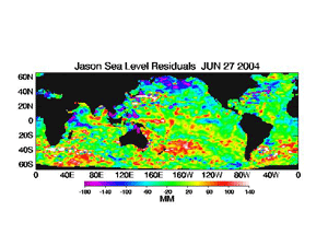
Above average trade wind flow was observed during June in the equatorial Pacific, resulting in negative zonal wind anomalies for the month. The increase in the trade winds enhanced equatorial and coastal upwelling, which increased the colder than average SST anomalies in the eastern equatorial Pacific and along the South American coast. The June average zonal wind field clearly illustrates that stronger than average easterly anomalies were present in the equatorial Pacific from South America to the dateline (180� longitude), with the strongest anomalies observed south of the equator. Satellite altimetry of ocean surface topography from the NASA/JPL Jason-1 satellite over the Pacific basin and global oceans is shown to the left. Decreases in sea-level and negative sea-level anomalies developed in the central equatorial Pacific in late June (see the 27 June 2004 overpass). |


|
Outgoing Longwave Radiation (OLR):
The monthly averaged OLR index value for June was negative across the region centered over the dateline in the western Pacific between 160� E and 160� W. Since the beginning of 2004 there has been no consistent trend in the OLR index, which has shifted sign several times after a nine-month period of positive values. The map to the left shows the spatial pattern of global OLR anomalies in June. The negative OLR anomalies in the western Pacific reflected areas of enhanced convection north of Indonesia in the northwestern tropical Pacific, as well as an area of enhanced convection associated with the South Pacific Convergence Zone (SPCZ), while positive OLR anomalies and supressed tropical convection was observed in June over the central and eastern Pacific just north of the equator. High frequency variability in OLR is typically associated with the Madden-Julian Oscillation (MJO) (MJO related convective activity propagates west to east in the near-equatorial region from the Indian Ocean into the Pacific Ocean approximately every 30-60 days). During June, there was a lack of MJO related activity across the Pacific basin, which was reflected in the positive OLR anomalies observed across the central and eastern Pacific. However, a moderate MJO event in the Indian Ocean moved into the far western Pacific at the end of June, likely enhancing convection in the western Pacific region. The latest MJO activity can be seen in CPC's graphs of Daily MJO Indices. |
 |
Southern Oscillation Index (SOI): Similar to the OLR index, there has been no consistent trend in the SOI in 2004. The standardized SOI shifted from a positive value in May to a negative one in June, with an averaged index value of -1.3 for the month. Since November 2003, the SOI has switched signs numerous times, reflecting the lack of any consistent mean-sea-level pressure pattern across the tropical Pacific associated with ENSO. |
MAY
   |
Sea-Surface Temperatures (SSTs) and
Mixed-Layer Conditions:
Above normal SST anomalies increased across the western equatorial Pacific in May, and this was reflected in the monthly averaged SST anomaly in the Ni�o 4 Index region. In the central equatorial Pacific, the SST anomalies decreased slightly in May, which led to a decrease in the monthly averaged Ni�o 3.4 index (map of Ni�o regions). For the most recent ocean surface temperature conditions, please see the loop of satellite-derived weekly SST anomalies for May.
The observed changes in the SST anomalies in these two Ni�o regions were evident in the data from NCDC's Extended Reconstructed Sea Surface Temperature dataset (ERSST v. 2). In May, the Ni�o 3.4 anomaly decreased to +0.14�C (+0.252�F) above normal, and the 3-month running mean decreased as well. Despite this slight cooling, the May value for the Ni�o 3.4 index continued the trend of above average equatorial SST conditions that began in June 2003. A running 3-month mean SST anomaly above +0.5�C in the Ni�o 3.4 region is one indicator that an El Ni�o is occurring. (For the official NOAA classification scheme, please see NOAA's El Ni�o/La Ni�a Index Definition and see the CPC ENSO Diagnostic Discussion for their latest official assessment of ENSO conditions). Sub-surface temperatures in the mixed-layer warmed across the equatorial Pacific region in May due to the passage of an oceanic Kelvin wave. Warmer water from the western Pacific propagated eastward during the month, and this eastward movement was evident in the loop of May sub-surface ocean temperatures and anomalies. The warmer surface and sub-surface conditions in the eastern Pacific during May were reflected in an increase of the monthly average depth of the 20�C isotherm, which is an approximate depth of the center of the oceanic thermocline (the oceanic thermocline in the eastern Pacific is anomalously deeper during El Ni�o episodes, and shallower during La Ni�a episodes). |
   |
Equatorial Zonal Winds (U-Component Winds) and Sea-Level Topography:
Zonal wind anomalies were negative across the eastern and central equatorial Pacific Ocean, and were the result of slightly above average easterly trade wind flow in May. The observed increase in the trade winds, which is clearly shown in the loop of May 5-day averaged zonal winds, helped to enhance equatorial and coastal upwelling and the development of the cold anomaly in the eastern equatorial Pacific and along the South American coast during the first half of the month. The May average zonal wind field clearly illustrates that stronger than average easterly anomalies were present in the equatorial Pacific from South America to 160�W. Satellite altimetry of ocean surface topography from the NASA/JPL Jason-1 satellite over the Pacific basin and global oceans is shown to the left. In the eastern equatorial Pacific, the observed decrease in sea-level and the negative sea-level anomalies began in March and continued into early May 2004, but the sea-level anomalies since that time have returned to near-normal along the equatorial zone in the eastern Pacific. |


|
Outgoing Longwave Radiation (OLR):
The average OLR index value for May was positive across the region centered over the western Pacific between 160� E and 160� W. The OLR Index has gone through a series of abrupt shifts that began in January 2004 when the index switched from a nine-month period of positive values. The map to the left shows the spatial pattern of global OLR anomalies in May. These negative OLR anomalies reflected areas of enhanced convection north of Indonesia in the northwestern tropical Pacific, as well as an area of enhanced convection associated with the South Pacific Convergence Zone (PCZ), while positive OLR anomalies and associated tropical convection was suppressed over the eastern Pacific along the equator. High frequency variability in OLR is typically associated with the Madden-Julian Oscillation (MJO) (MJO related convective activity propagates west to east in the near-equatorial region from the Indian Ocean into the Pacific Ocean approximately every 30-60 days). Enhanced convection related to MJO activity propagated eastward across the equatorial Pacific in April and early May, and a weaker MJO event moved into the western Pacific basin in mid-May. It is likely that the MJO event in April generated the oceanic Kelvin wave that slowly propagated eastward across the Pacific basin in May. The latest MJO activity can be seen in CPC's graphs of Daily MJO Indices. |
 |
Southern Oscillation Index (SOI): The standardized SOI shifted from a negative value in April to a positive one in May, with an averaged index value of 1.1 for the month. Since November 2003, the SOI has switched signs several times, reflecting the lack of any consistent mean-sea-level pressure pattern across the tropical Pacific associated with ENSO. In summary, the observed oceanic and atmospheric indices in May suggest that near-neutral ENSO conditions have continued to dominate the observed climatic conditions in the equatorial Pacific basin. However, significant changes in the oceanic mixed-layer did occur in May due to the passage of the Kelvin wave, which suggests that above normal SSTs will likely continue along the equator in the central Pacific and in the Ni�o 3.4 region. |
April
   |
Sea-Surface Temperatures (SSTs) and
Mixed-Layer Conditions:
Below normal SST anomalies developed across the eastern equatorial Pacific and along the South American coast in April, which enhanced the equatorial cold-tongue in this region. In the central and western equatorial Pacific, above average SST anomalies increased during the month, which were reflected by increases in the monthly averaged Ni�o 3.4 and Ni�o 4 indices (map of Ni�o regions). For the most recent oceanic temperature conditions, please see the loop of satellite-derived April weekly SST anomalies.
The increase in positive SST anomalies in the Ni�o 3.4 and Ni�o 4 regions (map of Ni�o regions) were evident in the data from NCDC's Extended Reconstructed Sea Surface Temperature dataset (ERSST v. 2 - note that this is the first month where version 2 of the ERSST dataset has been used). In April, the Ni�o 3.4 anomaly warmed to +0.32°C (+0.576°F) above normal, and the 3-month running mean warmed as well, which continued the trend of above average equatorial SST conditions that began in June 2003. A running 3-month mean SST anomaly above +0.5°C in the Ni�o 3.4 region is one indicator that an El Ni�o warm event is occurring. (For the official NOAA classification scheme, please see NOAA's El Ni�o/La Ni�a Index Definition and see the CPC ENSO Diagnostic Discussion for their latest official assessment of ENSO conditions). Sub-surface temperatures in the mixed-layer remained below normal across the eastern equatorial Pacific region in April. These below normal temperature anomalies were observed between the South American coast and 140°W during April. Warmer water from the western Pacific propagated eastward during the month, and this eastward movement was evident in the loop of April sub-surface ocean temperatures. The cooler surface and sub-surface conditions in the eastern Pacific during April were reflected in a decrease of the monthly average depth of the 20°C isotherm, which is an approximate depth of the center of the oceanic thermocline (the oceanic thermocline in the eastern Pacific is anomalously deeper during El Ni�o episodes, and shallower during La Ni�a episodes). |
   |
Equatorial Zonal Winds (U-Component Winds) and Sea-Level Topography:
Zonal wind anomalies were negative across the eastern equatorial Pacific Ocean, and were the result of stronger than average easterly trade wind flow in April. The trade winds were particularly strong during the latter half of the month. The observed increase in the trade winds, which is clearly shown in the loop of April 5-day averaged zonal winds, helped to enhance equatorial upwelling and the development of the cold-tongue in the eastern equatorial Pacific. The April mean clearly illustrates that stronger than average easterly anomalies were present in the eastern Pacific from South America to 130°W, as well as a narrow band of negative zonal wind anomalies immediately along the equator extending westward from 130°W to the dateline.
Satellite altimetry of ocean surface topography from the NASA/JPL Jason-1 satellite over the Pacific basin and global oceans are shown to the left. In the eastern equatorial Pacific, the observed decrease in sea-level and the negative sea-level anomalies began in March and continued into April 2004, which clearly reflects the enhanced trade wind flow in the near-equatorial region that was observed by the TAO buoy array during this time-period. |


|
Outgoing Longwave Radiation (OLR):
The average OLR index value for April was negative across the region centered over the western Pacific between 160° E and 160° W. The April index was the second consecutive negative monthly value, which was preceded by a series of abrupt shifts that began in January 2004 when the index switched from a nine-month period of positive values. The map to the left shows the spatial pattern of OLR anomalies in April. These OLR anomalies reflected areas of enhanced convection north of Indonesia in the northwestern tropical Pacific, while convection was suppressed over the equatorial eastern Pacific region. High frequency variability in OLR is typically associated with the Madden-Julian Oscillation (MJO) (MJO related convective activity propagates west to east in the near-equatorial region from the Indian Ocean into the Pacific Ocean approximately every 30-60 days). Enhanced convection related to MJO activity propagated eastward across the equatorial Pacific in late March, and another, albeit weaker, MJO event moved across the Pacific basin in April. Despite the influence of MJO activity, deep tropical convection remained over the far western part of the Pacific Basin, and no significant tropical convection had developed east of the dateline. The latest MJO activity can be seen in CPC's graphs of Daily MJO Indices. |
 |
Southern Oscillation Index (SOI): The standardized SOI was negative for the second consecutive month, with an averaged index value of -1.3 for April. Since November 2003, the SOI has switched signs several times, reflecting the lack of any consistent mean-sea-level pressure pattern across the tropical Pacific associated with ENSO. The observed oceanic and atmospheric indices in April suggest that near-neutral ENSO conditions have remained across the equatorial Pacific basin. Although cooler SSTs in the eastern Pacific may appear to indicate a shift toward an ENSO cold event (i.e. La Ni�a), it is interesting to note that similar conditions developed in May 2003, but were abruptly changed due to MJO activity that generated an oceanic Kelvin wave in May-June 2003. Atmospheric forcing (i.e. westerly wind bursts) associated with past El Ni�os and La Ni�as has developed quickly, and therefore conditions will be monitored closely over the critical May-June period for potential changes in the state of ENSO. |
March
   |
Sea-Surface Temperatures (SSTs) and
Mixed-Layer Conditions:
SSTs decreased across the central and eastern equatorial Pacific in March. The observed SST anomalies remained slightly above normal in the central equatorial Pacific, and slightly below normal in the western equatorial Pacific, which were reflected by decreases in the monthly averaged Ni�o 3.4 and Ni�o 4 indices (map of Ni�o regions). For the latest oceanic temperature conditions, please see the loop of satellite images of March weekly SST anomalies.
The decreases in SSTs in the Ni�o 3.4 and Ni�o 4 regions (map of Ni�o regions) were evident in the data from NCDC's Extended Reconstructed Sea Surface Temperature (ERSST) dataset. March was the ninth consecutive month where the observed SST anomaly in the Ni�o 3.4 region was above average for the central Pacific. Although slightly warmer than average for the month, the Ni�o 3.4 anomaly cooled to +0.07°C (+0.126°F) above normal, while the 3-month running mean cooled as well (+0.19°C; +0.35°F), which continued a trend toward neutral SST conditions that began in December 2003. A running 3-month mean SST anomaly above +0.5°C in the Ni�o 3.4 region is one indicator that an El Ni�o warm event is occurring. (For the official NOAA classification scheme, please see NOAA's El Ni�o/La Ni�a Index Definition and see the CPC ENSO Diagnostic Discussion for their latest official assessment of ENSO conditions). Sub-surface temperatures also cooled across the central and eastern Pacific region in March. Positive sub-surface temperature anomalies that were present at the beginning of March began to cool during the month, with below normal temperatures developing in the mixed-layer and spreading eastward. These below normal temperature anomalies propagated quickly eastward during March, and were centered at approximately at 130°W by the end of the month. This eastward movement was evident in the loop of March sub-surface ocean temperatures, and was associated with a strengthening of the near-equatorial easterly trade winds. The cooler surface and sub-surface conditions in the eastern Pacific during March were reflected in a decrease of the monthly average depth of the 20° C isotherm, which is used as an approximate depth of the oceanic thermocline (the oceanic thermocline in the eastern Pacific is anomalously deeper during El Ni�o episodes, and shallower during La Ni�a episodes). |

|
Equatorial Zonal Winds (U-Component Wind): In March, the near-equatorial zonal wind anomalies were negative, which reflected the stronger than average easterly trade wind flow across the equatorial Pacific. The anomalously strong trade winds were especially evident during the first part of the month, when several periods of enhanced easterly flow were observed across the basin. This observed increase is clearly shown in the March 5-day averaged zonal winds. These 5-day mean zonal wind speeds illustrate high-frequency fluctuations in the strength of the trade winds, and the March monthly average composite showed that the stronger than average easterly anomalies were present across the equatorial Pacific to the dateline. |


|
Outgoing Longwave Radiation (OLR):
The average OLR index value for March was slightly negative across the region centered between 160° E and 160° W. The negative March anomaly was the third in a series of abrupt shifts that began in January, when the index shifted from a nine-month period of positive values to a negative value for the month. The map to the left for the period 16 February through 16 March clearly shows a widespread area of negative OLR anomalies in the far western Pacific, while positive OLR anomalies were observed over a broad area of the central equatorial Pacific. These OLR anomalies reflected areas of enhanced convection that were present across Indonesia and adjacent areas of the northwestern tropical Pacific, while suppressed convection was present over the equatorial central Pacific. Therefore, the March OLR signal was indicative of near-neutral conditions in the Pacific basin. High frequency variability in OLR is associated with the Madden-Julian Oscillation (MJO) (MJO related convective activity propagates west to east in the near-equatorial region from the Indian Ocean into the Pacific Ocean approximately every 30-60 days). Enhanced convection associated with MJO activity propagated eastward in early-February, and another, albeit weaker, MJO event moved into the basin in late February and early March. Despite the influence of the MJO, deep tropical convection remained over the far western part of the Pacific Basin, and no significant anomalies had developed east of the dateline in March. However, a stronger MJO event did develop at the very end of March in the Indian Ocean, and the associated convection began to move eastward into the western Pacific in early April. The latest MJO activity can be seen in CPC's graphs of Daily MJO Indices. |

|
Southern Oscillation Index (SOI): For the fourth consecutive month the standardized SOI shifted sign, with a monthly averaged index value of -0.2 for March. Since November, the SOI has switched signs each month, reflecting the lack of any sustained and coherent trend in the mean-sea-level pressure pattern across the Pacific basin associated with ENSO. In-depth monitoring of the SOI and other atmospheric and oceanic indices over the next several months may provide better indications of the evolution of ENSO, since ENSO warm and cold events are often initiated during the latter half of the Northern Hemisphere spring (April-June). The current set of indices, both oceanic and atmospheric, illustrate near-neutral ENSO conditions and no clearly defined shift toward a cold or warm event in the equatorial Pacific basin. However, atmospheric forcing (i.e. westerly wind bursts) associated with past El Ni�os and La Ni�as has developed quickly, and therefore conditions will be monitored closely over the critical late-spring period. |
February


|
Sea-Surface Temperatures (SSTs) and
Mixed-Layer Conditions:
Slightly above average sea-surface temperatures (SST) remained across the western and central equatorial Pacific in February, but SST anomalies decreased during the past two months, and were cooler than normal across the eastern Pacific in the Ni�o 1+2 region (map of Ni�o regions). For the lastest oceanic temperature conditions, please see the loop of satellite images of February weekly SST anomalies.
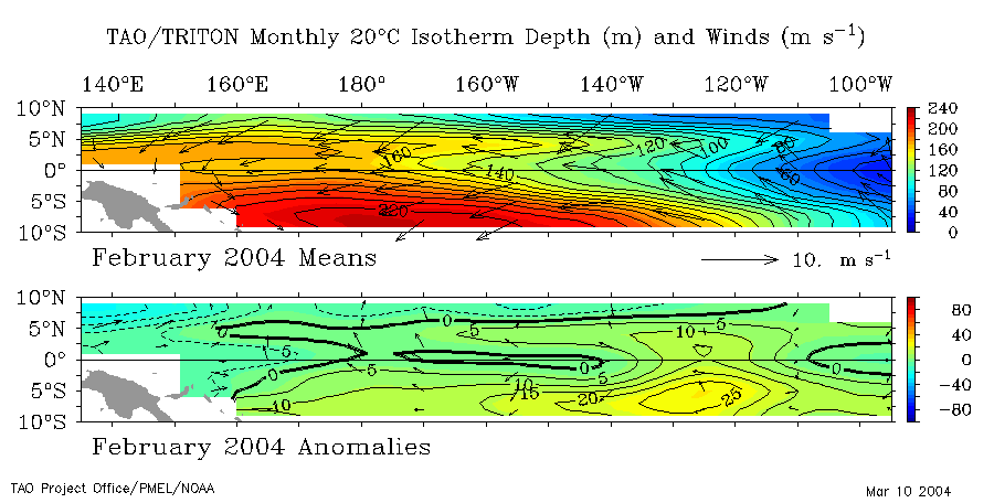
Sub-surface temperatures were cooler than normal in the eastern Pacific in February. Previously, the +2° C mixed-layer anomalies present back in December near 110° W were absent from the January average. However, positive sub-surface temperature anomalies in the central Pacific mixed-layer intensified in January, and propagated eastward during February, and were centered at approximately at 120°W for the month. This movement was evident in a loop of February sub-surface ocean temperatures, and was associated with an eastward propagating oceanic Kelvin Wave. This Kelvin Wave was inititated by a weakening of the equatorial easterlies and enhanced MJO activity in late December. At current rates of propagation (about 8-10 degrees of longitude per week) it is expected to reach the South American coast by mid-March. The cooler surface and sub-surface conditions in the eastern Pacific were reflected in a small reduction of the monthly average depth of the 20° C isotherm, which is used as an approximate depth of the oceanic thermocline (the oceanic thermocline in the eastern Pacific is anomalously deeper during El Ni�o episodes, and shallower during La Ni�a episodes). SSTs in the Ni�o 3.4 region (map of Ni�o regions) were again warmer than normal, based on data from NCDC's Extended Reconstructed Sea Surface Temperature dataset (ERSST). February was the eighth consecutive month where the observed SST anomaly was above average for the central Pacific. Although warmer than average, the February anomaly in the Ni�o 3.4 region decreased in February, and was only +0.15° C (+0.27° F), while the 3-month running mean cooled as well, remaining below +0.5° C. A running 3-month mean SST anomaly above +0.5° C in the Ni�o 3.4 region is one indicator that an El Ni�o warm event is occurring. (For the official NOAA classification scheme, please see NOAA's El Ni�o/La Ni�a Index Definition and see the CPC ENSO Diagnostic Discussion for their latest official assessment of ENSO conditions.) |

|
Equatorial Zonal Winds (U-Component Wind): Equatorial zonal wind anomalies were negative in February, reflecting stronger than average easterly trade wind flow across the Pacific basin. This observed increase in the near-equatorial trade winds is clearly shown in the February 5-day averaged zonal winds. The 5-day averages illustrate high-frequency fluctuations in the strength of the Trade winds, but overall the February monthly mean showed that the stronger than average easterlies propagated across equatorial Pacific to the dateline. |


|
Outgoing Longwave Radiation (OLR):
Although week-to-week variability in OLR anomalies continued in February, the average OLR index value for the month was positive across the region centered between 160° E and 160° W. The positive February anomaly was an abrupt shift from January's negative value, which had been the first month since March 2003 with a negative monthly anomaly. However, the map to the left for the period February 9 through March 9 clearly shows a widespread area of negative anomalies in the western Pacific, which is indicative of enhanced convection. In general, areas of enhanced convection were present across Indonesia and other areas in the western Pacific, while areas of suppressed convection were present over the central Pacific. Therefore, the February OLR signal indicated near-neutral conditions, and was not indicative of an El Ni�o warm event. The week-to-week variability in OLR was associated with the Madden-Julian Oscillation (MJO). MJO related convective activity propagates west to east in the near-equatorial region from the Indian Ocean into the Pacific Ocean approximately every 30-60 days. MJO activity in January propagated eastward in early-February, and another, albeit weaker, MJO event moved into the basin in mid-February. Despite the influence of the MJO, deep tropical convection remained over the far west of the Pacific Basin, and no significant anomalies had developed east of the dateline. The latest MJO activity can be seen in CPC's graphs of Daily MJO Indices. |

|
Southern Oscillation Index (SOI): The standardized SOI abruptly shifted again from negative to positive in February. Since November, the SOI has switched signs each month, reflecting the lack of any sustained and persistent trend in the mean-sea-level pressure pattern across the Pacific basin. Previously, the SOI had been negative for most of the past 24 months. Strongly negative values of the SOI are often indicative of El Ni�o conditions, with strongly positive values indicative of La Ni�a conditions. Careful monitoring of the SOI and other atmospheric and oceanic indices will be critical over the next three months, since ENSO warm and cold events are typically initiated during latter half of the Northern Hemisphere spring (April-June). Overall, the current set of indicators suggest near-neutral conditions and no clear movement toward a cold or warm event. However, factors influencing past events have developed quickly, and therefore conditions must be monitored closely over the critical April-June period . |
January


|
Sea-Surface Temperatures (SSTs) and
Mixed-Layer Conditions:
Warmer than average sea-surface temperatures (SST) remained across much of the equatorial Pacific in January, but temperatures were cooler than the October - early December 2003 peak values in all four Nino regions. For the latest oceanic temperature conditions, please see the loop of satellite images of January weekly SST anomalies.
In the oceanic mixed-layer, temperatures were cooler in the eastern Pacific as the +2° C anomalies present in December near 110° W were absent from the January average. However the positive sub-surface temperature anomaly in the central Pacific mixed-layer intensified and moved further east. This movement is evident in a (loop of January sub-surface ocean temperatures) and is associated with an eastward propagating Kelvin Wave. This Kelvin Wave was inititated by a weakening of the equatorial easterlies and enhanced MJO activity in late December and is expected to reach the South American coast by the end of February, according to NOAA's Climate Prediction Center (CPC) . The cooler surface and sub-surface conditions in the eastern Pacific were reflected in a small reduction of the monthly average depth of the 20° C isotherm, which is used as an approximate depth of the thermocline. (The oceanic thermocline in the eastern Pacific is deeper during El Ni�o episodes.) The depth was less than 50 meters by late January in the equatorial region east of 100° West. SSTs in the Ni�o 3.4 and Ni�o 4 regions were again warmer than normal based on data from NCDC's Extended Reconstructed Sea Surface Temperature dataset (ERSST) (map of Ni�o regions). This is the seventh and eighth consecutive months, respectively, where the observed SST anomalies were above average for the central and western Pacific Ni�o regions. Although warmer than average, the January anomaly in the Ni�o 3.4 region was less than +0.5° C (+.90° F) for the first time since September 2003 and the 3-month running mean was +0.49° C. A running 3-month mean SST anomaly above +0.5° C in the Ni�o 3.4 region is one indicator that a warm event is occurring. (For the official NOAA classification scheme, please see NOAA's El Ni�o/La Ni�a Index Definition and see the CPC ENSO Diagnostic Discussion for the latest official assessment of ENSO conditions.) |

|
Equatorial Zonal Winds (U-Component Wind): As in recent months, there continued to be considerable variability in equatorial winds from week to week during January. The westerly component present in the western and central Pacific in late December propagated eastward during January as shown in this animation of 5-day averaged zonal winds, but the equatorial easterlies became stronger during the latter half of the month throughout the equatorial Pacific. For January, the averaged zonal (U-component) wind-field reflected the weaker than average easterlies in the central Pacific during the first half of the month. These equatorial wind fields are measured by NOAA's Tropical Atmosphere-Ocean (TAO) Array buoy network. |

|
Outgoing
Longwave Radiation (OLR):
Although week-to-week variability in anomalies of Outgoing Longwave Radiation also continued in January, the average OLR for the month was negative in the region centered between 160° E and 160° W. This was the first occurrence of negative OLR anomalies since March 2003. However, the map to the left for the period January 13 through February 11 shows widespread areas of positive anomalies in the central Pacific, which is indicative of suppressed convection. Areas of enhanced convection were present in Indonesia, northern Australia and other areas in the western Pacific. The week-to-week variability in OLR is associated with the Madden-Julian Oscillation (MJO). MJO related convective activity propagates west to east in the near-equatorial region from the Indian Ocean into the Pacific Ocean approximately every 30-60 days. Indications of the convectively active phase of the MJO over the Indian Ocean in late January suggests that enhanced convection may shift into the western and central Pacific in February. The latest MJO event can be seen in CPC's graphs of Daily MJO Indices. |
|
|
Southern Oscillation Index (SOI): Although the standardized SOI abruptly shifted from negative to positive in December, it returned to its negative phase in January. The SOI has been negative for most of the past 24 months. Strongly negative values of the SOI are often indicative of El Ni�o conditions. Continued monitoring of these and other conditions in the equatorial Pacific in coming months will help determine the evolution of ENSO. |
ENSO related Links
Questions?
- For all climate questions other than questions concerning this report, please contact the National Climatic Data Center's Climate Services Division:
| Climate Services Division NOAA/National Climatic Data Center 151 Patton Avenue Asheville, NC 28801-5001 fax: 828-271-4876 phone: 828-271-4800 email: questions@ncdc.noaa.gov |
- For comments and suggestions on this web page, contact:
|
David Levinson NOAA/National Climatic Data Center 151 Patton Avenue Asheville, NC 28801-5001 fax: 828-271-4328 email: David.Levinson@noaa.gov |
- -or-
|
Jay Lawrimore NOAA/National Climatic Data Center 151 Patton Avenue Asheville, NC 28801-5001 fax: 828-271-4328 email: Jay.Lawrimore@noaa.gov |
 NCDC / Climate Monitoring / Climate of 2004 / Latest Monthly Report / ENSO / Search / Help
http://www.ncdc.noaa.gov/oa/climate/research/2004/enso-monitoring.html
Downloaded Sunday, 21-Sep-2008 04:41:12 EDT
Last Updated Thursday, 13-Jan-2005 10:54:16 EST by David.Levinson@noaa.gov
Please see the NCDC Contact Page if you have questions or comments.