USGS - science for a changing world

Kansas Water Science Center

Homehome Sudieswater data & studies Research Labresearch lab Pubspublications Floodflood Droughtdrought Contactcontact
Contract All | Expand All
WATER DATA & STUDIES
DATA CENTER
INFORMATION CENTER
ABOUT KANSAS WSC
USGS IN YOUR STATE

USGS Water Science Centers are located in each state.

There is a USGS Water Science Center office in each State. Washington Oregon California Idaho Nevada Montana Wyoming Utah Colorado Arizona New Mexico North Dakota South Dakota Nebraska Kansas Oklahoma Texas Minnesota Iowa Missouri Arkansas Louisiana Wisconsin Illinois Mississippi Michigan Indiana Ohio Kentucky Tennessee Alabama Pennsylvania West Virginia Georgia Florida Caribbean Alaska Hawaii New York Vermont New Hampshire Maine Massachusetts South Carolina North Carolina Rhode Island Virginia Connecticut New Jersey Maryland-Delaware-D.C.

Water Quality

Location of streamflow gaging stations with water-quality monitors

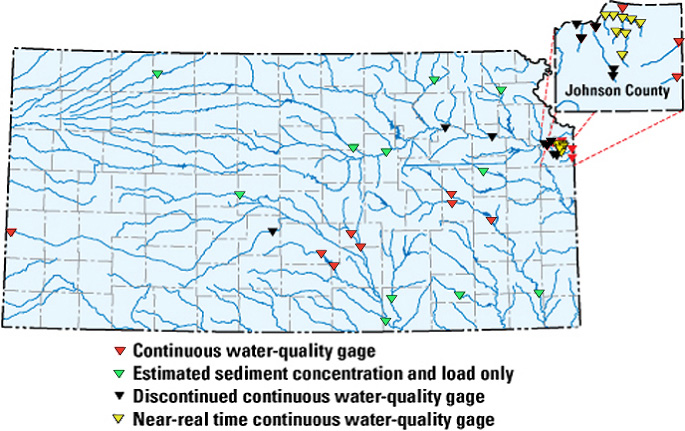
This map shows USGS streamgages (red, green, black and yellow triangles) in Kansas from which estimated concentrations and loads are available.


Real-time Water Quality

U.S. Geological Survey (USGS) development of a real-time water-quality monitoring system for 13 sites in Kansas began in 1998 in cooperation with the city of Wichita as part of the Equus Beds Groundwater Recharge Demonstration Project. Real-time estimates from the monitoring system eliminates the waiting time inherent in chemical analyses to be reported by a laboratory and provides continuous concentrations and loads. The city of Wichita can then alter treatment of the water to meet the changes in the water quality in the Little Arkansas River and prevent degradation of the Equus Beds aquifer by artificial recharge.

Real-time water-quality information in the monitoring system includes hourly measurements of streamflow, specific conductance, pH, water temperature, dissolved oxygen, and turbidity. Because sensor technology currently is not available to directly measure many chemicals of interest in a stream, statistical models are developed to link constituents in laboratory-analyzed samples with the in-stream continuous-sensor measurements. As the hourly sensor measurements are transmitted from the gaging stations to the USGS computers in Lawrence, Kansas, the models are applied and the computed estimates displayed to the web page. The uncertainty of the estimates also is documented so decisions made on the basis of the estimates can be put in proper management perspective.

Estimated real-time 
fecal coliform bacteria concentration in Kansas River DeSoto, KS


Organic Geochemistry Research Laboratory

The Organic Geochemistry Research Laboratory (OGRL) focuses on two important issues of multidisciplinary research. First, is the fate, transport, and degradation of organic contaminants in the environment with special on nonpoint-source contamination from agricultural chemicals. Second, are in the environment emerging contaminants and how they affect the water. These compounds are combined with analytical methods to determine and link to both geochemical and hydrologic processes.


Cyanobacterial (Blue-Green Algal) Blooms:
  Tastes, Odors, and Toxins

Cyanobacteria (also called blue-green algae) cause a multitude of water-quality concerns, including the potential to produce taste-and-odor causing compounds and toxins that are potent enough to poison animals and humans. Taste-and-odor compounds and toxins are of particular concern in lakes, reservoirs, and rivers that are used for either drinking water supplies or full body contact recreation. Taste-and-odor compounds cause malodorous or unpalatable drinking water and fish, resulting in increased treatment costs and loss of aquacultural and recreational revenue.  Cyanobacterial toxins (cyanotoxins) have been implicated in human and animal illness and death in over fifty countries worldwide, including at least 32 U.S. States.  Human toxicoses associated with cyanotoxins have most commonly occurred after exposure through drinking water or recreational activities.

Gaging Station

Cyanobacteria may produce taste-and-odor
compounds that cause malodorous or unpalatable drinking water.
Cheney Reservoir, Kansas.  June 2003.
Photo Courtesy of KDHE.


High Plains Regional Ground Water Quality Study

As part of the the NAtional Water-Quality Assessment (NAWQA) Program, the USGS is evaluating ground-water quality in the High Plains aquifer system.

Location of the High Plains study area in the central United States.

The High Plains aquifer system underlies 175,000 square miles in parts of eight States (CO, KS, NE, NM, OK, SD, TX, and WY) (figure 1). Approximately 27 percent of the irrigated land in the United States is in the High Plains and about 30 percent of the ground water used for irrigation in the U.S. is pumped from the High Plains aquifer.

The quality of water in the High Plains aquifer generally is suitable for irrigation use but, in many places, the water does not meet U.S. Environmental Protection Agency drinking-water standards with respect to several dissolved constituents (dissolved solids/salinity, fluoride, chloride, and sulfate). Only sparsely scattered water-quality data are available for pesticides, volatile organic compounds, and trace metals in the High Plains aquifer system. Nutrient data are available, to a varying degree, across the aquifer.

USGS Home Water Resources Biology Geography Geology Geospatial

Accessibility FOIA Privacy Policies and Notices

Take Pride in America logo USA.gov logo U.S. Department of the Interior | U.S. Geological Survey
URL: /water-quality.html
Page Contact Information: GS-W-KS_info@usgs.gov
Page Last Modified:Thursday, 18-Sep-2008 15:50:22 CDT