Kansas Water Science Center
 WATER DATA & STUDIES WATER DATA & STUDIES
DATA CENTER
INFORMATION CENTER
ABOUT KANSAS WSCUSGS IN YOUR STATEUSGS Water Science Centers are located in each state. 
|
Ground WaterEquus Beds Ground-Water Recharge Project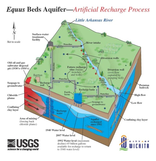 Schematic of the artificial recharge process Description of StudyThe water supply for the city of Wichita, south-central Kansas, currently comes from the Equus Beds aquifer and Cheney Reservoir. Because these sources are not expected to meet projected city water needs into the 21st century (Warren and others, 1995), artificial recharge of the Equus Beds aquifer is being investigated as one alternative to meet future water-supply demands. An additional potential benefit of artificial recharge includes preventing degradation of the water quality of the aquifer by saltwater plumes from the Arkansas River to the southwest and the Burrton oil field to the northwest (Ziegler and others, 1999). Water from the Little Arkansas River was diverted for artificial recharge when flow in the river exceeded base flow. USGS monitoring of the water quantity and quality has continued in the Little Arkansas River and at monitoring wells throughout the study area since the completion of the demonstration phase of the Equus Recharge Project (May 2002). An areal assessment for water quantity and water quality in the Equus Beds aquifer also began in November 2001.
High Plains Water-Level Monitoring StudyThe High Plains Water-Level Monitoring Study (HPWLMS) is the USGS's response to a directive from Congress to report on water-level changes in the High Plains [Ogallala] aquifer The objectives of the HPWLMS are:
OZARK AQUIFER STUDY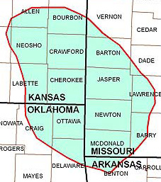 To address water supply and quality issues in the Ozark Aquifer, the U.S. Geological Survey initiated a three- year study in August 2005 in cooperation with the efforts of the state water agencies in the Tri-State area (Kansas, Oklahoma, Missouri). A model is being developed that will simulate ground-water flow within the Ozark and Springfield Plateau aquifers and include interaction between ground and surface water. The model will allow resource managers to simulate the effect of additional ground water withdrawals and provide valuable water availability information. The study also will assess the current water-quality conditions in the Ozark aquifer and provide information on vertical variability of water quality within the aquifer near Pittsburg, Kansas, where brackish water intrusion is a concern. |

![]() U.S. Department of the Interior |
U.S. Geological Survey
U.S. Department of the Interior |
U.S. Geological Survey
URL: /ground-water.html
Page Contact Information: GS-W-KS_info@usgs.gov
Page Last Modified:Thursday, 25-Sep-2008 10:08:59 CDT

 In addition USGS has documented Water level changes in the Equus Beds began in 1940.