Tropical Cyclone Report
Tropical Storm Josephine
17 - 19 September 2002
Richard J. Pasch
National Hurricane Center
14 January 2003
Josephine was a short-lived, high latitude tropical storm well
out at sea.
a. Synoptic History
Josephine was of non-tropical origin. Surface data indicated
that a weak low pressure system formed along a dissipating, nearly
stationary frontal zone about 750 n mi east of Bermuda on 16
September. Over the next day, as the low moved slowly westward, a
small area of deep convection formed near the low-level circulation
center and the system's cloud pattern changed from one that
resembled a non-tropical cyclone to that of a tropical cyclone. It
is estimated that the system became a tropical depression around
1200 UTC 17 September, while centered about 620 n mi east of
Bermuda. The tropical cyclone moved slowly north-northwestward to
northward for about a day. Deep convection associated with the
system was intermittent and at times the low-level center became
exposed. However, the cyclone strengthened slightly and is
estimated to have become a tropical storm by 0600 UTC 18 September.
Soon thereafter, Josephine accelerated northeastward in the flow
ahead of a deep-layer mid-latitude trough. The system lost its
tropical characteristics around 1200 UTC 19 September, at which
time a ship report indicated that the cyclone had strengthened into
an storm with winds near 50 kt well removed from the center. Soon
thereafter, the storm merged with a larger extratropical low and
frontal system. The "best track" chart of Josephine's path is
displayed in Figure 1, with the wind and pressure histories shown in
Figure 2 and Figure 3,
respectively. The best track positions and
intensities are listed in Table 1.
b. Meteorological Statistics
Observations in Josephine (Figure 2 and Figure 3)
include satellite-based Dvorak technique intensity estimates from the
Tropical Analysis and Forecast Branch (TAFB), the Satellite
Analysis Branch (SAB) and the U. S. Air Force Weather Agency
(AFWA). Additionally, there was a report of 37 kt winds from a ship
(see Table 2) as well as QuikSCAT and SSM/I winds near 35 kt around
0600 UTC 18 September. When Josephine became extratropical at 1200
UTC 19 September, a ship with call sign C6LV3 reported 50 kt winds
about 76 n mi southeast of the center.
c. Casualty and Damage Statistics
There were no reports of damages or casualties associated with
Josephine.
d. Forecast and Warning Critique
Josephine was a tropical storm for only about a day, so there
are no meaningful forecast statistics. In general, the official
forecasts correctly anticipated that the cyclone would accelerate
northeastward, and that it would not strengthen significantly as a
tropical cyclone. Watches or warnings were not required for
Josephine.
Table 1: Best track for Tropical Storm Josephine, 17-19
September 2002.
Date/Time
(UTC) | Position | Pressure
(mb) | Wind Speed
(kt) | Stage |
Lat.
(°N) | Lon.
(°W) |
| 17 / 1200 | 32.7 | 52.4 | 1016 | 30 | tropical depression |
| 17 / 1800 | 33.2 | 52.7 | 1015 | 30 | " |
| 18 / 0000 | 33.7 | 52.7 | 1014 | 30 | " |
| 18 / 0600 | 34.7 | 52.7 | 1009 | 35 | tropical storm |
| 18 / 1200 | 35.5 | 52.0 | 1009 | 35 | " |
| 18 / 1800 | 36.6 | 50.5 | 1009 | 35 | " |
| 19 / 0000 | 38.0 | 48.8 | 1009 | 35 | " |
| 19 / 0600 | 39.5 | 46.7 | 1009 | 35 | " |
| 19 / 1200 | 41.5 | 43.3 | 1004 | 50 | extratropical |
| 19 / 1800 | | | | | merged with larger extratropical cyclone |
| 19 / 0600 | 39.5 | 46.7 | 1009 | 35 | minimum pressure |
Table 2: Selected ship reports with winds of at least 34 kt for
Tropical Storm Josephine, September 2002.
| Ship Name or Call Sign | Date/Time (UTC) | Lat.
(°N) | Lon.
(°W) | Wind dir/speed (deg/kt) | Pressure (mb) |
| PDKK | 18 / 0300 | 34.1 | 52.0 | 190 / 37 | 1010.8 |
|
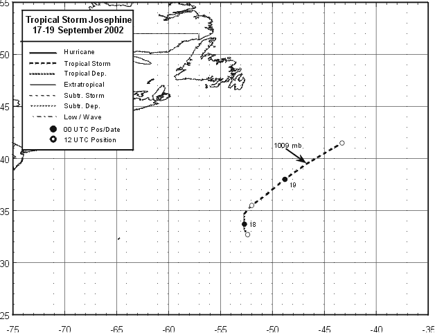
Figure 1:
Best track positions for Tropical Storm Josephine, 17-19
September 2002. Minimum pressure (mb) at arrowhead.
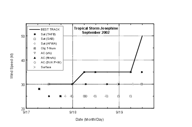
Figure 2:
Best track maximum sustained surface wind speed curve and
satellite-derived intensity estimates for Tropical Storm Josephine, 17-19
September 2002.
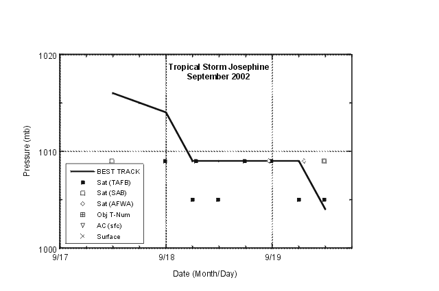
Figure 3:
Best track minimum central pressure curve and
satellite-derived pressure estimates for Tropical Storm Josephine, 17-19
September 2002.
|


