Tropical Cyclone Report
Tropical Storm Edouard
1 - 6 September 2002
Richard J. Pasch
National Hurricane Center
16 January 2003
Edouard made landfall on the northeast coast of Florida as a
minimal tropical storm.
a. Synoptic History
Edouard formed from a disturbance of non-tropical origin.
Cloudiness and isolated showers developed several hundred miles
east-southeast of Bermuda on 25 August, likely in association with
a low-level disturbance that had formed along a dying frontal zone.
The system moved southwestward for several days, and when the
disturbance was located near the southwest end of an upper-level
trough a few hundred miles north of Puerto Rico, deep convection
associated with the system increased. The area of disturbed weather
moved slowly westward over the next couple of days, and on the
31st, when the system was located just to the east of
the northern Bahamas, it began to become better organized. On 1
September deep convection became persistent, and surface and
reconnaissance aircraft data indicate the system became a tropical
depression around 1800 UTC that day, centered about 120 n mi east
of Daytona Beach, Florida. Figure 1
is a map showing the best track
of the tropical cyclone, and Table 1. contains a listing of the best
track
In the early stage of the tropical cyclone, the environment was
characterized by modest west-northwesterly shear, and the system
strengthened into Tropical Storm Edouard by 0600 UTC 2 September.
Later that day and early on the 3rd, the environment
appeared to become more hostile. Water vapor imagery suggested that
dry mid- to upper-tropospheric air was overspreading the center,
and radiosonde data indicated 30 to 40 kt winds affecting the storm
at the 200 mb level. Despite this, Edouard was able to intensify
further, and it reached its peak strength of 55 kt around 1200 UTC
3 September. However, very soon thereafter, the storm soon began to
succumb to the influence of strong shear and dry air aloft and a
weakening trend was underway. By midday on the 3rd, the
associated deep convection had decreased, and the low-cloud
circulation center was clearly exposed.
Soon after Edouard's genesis, steering currents weakened. From
2-3 September, the cyclone moved in a clockwise loop. Then, as a
weak and narrow mid-tropospheric ridge developed to its north,
Edouard headed erratically westward and west-southwestward toward
the northeast coast of Florida. Strong shear continued to impact
the system, and although occasional bursts of deep convection
occurred near the center, the cyclone was barely of tropical storm
strength when the center crossed the coastline in the vicinity of
Ormond Beach, Florida around 0045 UTC 5 September. Edouard weakened
to a depression almost immediately after landfall, and crossed
north-central Florida. The weak depression emerged into the Gulf of
Mexico near Crystal River, Florida around 1400 UTC on the
5th. Strong northwesterly shear, associated with the
upper-tropospheric outflow from developing Tropical Storm Fay
located over the western Gulf, precluded any redevelopment of
Edouard. On the 6th, Tropical Depression Edouard moved
westward over the northeastern Gulf, and by 1200 UTC on that day,
it was a rather insignificant-looking low cloud swirl with minimal
deep convection. The system dissipated shortly thereafter, as it
became absorbed into the larger circulation of Tropical Storm
Fay.
b. Meteorological Statistics
Figure 2 and Figure 3
are curves of the best track maximum wind speed
and minimum central pressure for Edouard, along with the
observations on which these curves are based. Observations for
Edouard include satellite-based Dvorak technique intensity
estimates from the Tropical Analysis and Forecast Branch (TAFB),
the Satellite Analysis Branch (SAB) and the U. S. Air Force Weather
Agency (AFWA), as well as flight-level observations from flights of
the 53rd Weather Reconnaissance Squadron of the U. S.
Air Force Reserve Command. The peak intensity of Edouard, 55 kt, is
based on a reconnaissance aircraft wind measurement of 71 kt at a
flight level of about 1000 ft at 1159 UTC 3 September.
Table 2 lists ship reports of tropical storm force winds
associated with Edouard. There were no reports of sustained
tropical storm force winds over land associated with Edouard. On 4
September, Patrick Air Force Base reported a peak wind gust of 34
kt at 2127 UTC , and the St. Augustine C-MAN station reported a
peak gust of 33 kt at 1900 UTC. Reliable rainfall estimates from
the Melbourne radar indicated maxima of 4 to 5 inches near the
Seminole/Orange County line, just northeast of Union Park (Orange
County) Florida. Storm tides and wave action were not significant,
and there were no tornadoes reported.
c. Casualty and Damage Statistics
There were no reports of casualties due to Edouard. Some
flooding occurred in Brevard, Seminole, and Orange counties in
Florida. This appears to have been mainly roadway flooding and
damages, if any, appeared to be minor. No dollar amounts are
available.
d. Forecast and Warning Critique
Edouard was of tropical storm strength for less than 72 h, so
there is a relatively small sample of forecasts to verify through
48 h. Excluding the tropical depression stage, the average official
track forecast errors for Edouard (with the number of cases in
parentheses) are 32 (10), 57 (8), 75 (6), and 90 (4) for the 12,
24, 36, and 48 h forecasts, respectively. These errors are less
than the most recent 10-yr average average official track errors
for the Atlantic basin. The GUNS and GUNA ensemble forecasts had
somewhat lower average track errors than the official forecasts. In
general, the official track predictions correctly called for
Edouard to loop back and make landfall along the southeast U.S.
coast.
Average official intensity errors were 6, 7, 8, and 13 kt for
the 12, 24, 36, and 48 h forecasts, respectively. For comparison,
the average official intensity errors over the most recent 10-yr
period are 7, 11, 14, and 16 kt, respectively. Although there was a
positive bias to the wind speed forecasts at 36 and 48 h, the
official forecasts correctly recognized that strong shear would
inhibit significant intensification.
Table 3 lists the watches and warnings associated with Edouard.
A tropical storm warning was issued early on 2 September while
Edouard was moving slowly northwestward The looping motion delayed
the threat to the coastline, however, resulting in the
discontinuation of tropical storm warnings later that day. A
tropical storm warning was re-issued for the northeast Florida
coast about 16 h prior to landfall.
Table 1: Best track for Tropical Storm Edouard, 1-6 September
2002
Date/Time
(UTC) | Position | Pressure
(mb) | Wind Speed
(kt) | Stage |
Lat.
(°N) | Lon.
(°W) |
| 01 / 1800 | 29.2 | 78.8 | 1013 | 30 | tropical depression |
| 02 / 0000 | 29.7 | 79.1 | 1011 | 30 | " |
| 02 / 0600 | 30.1 | 79.7 | 1007 | 35 | tropical storm |
| 02 / 1200 | 30.4 | 79.6 | 1007 | 35 | " |
| 02 / 1800 | 30.5 | 79.0 | 1005 | 35 | " |
| 03 / 0000 | 30.5 | 78.6 | 1003 | 35 | " |
| 03 / 0600 | 30.4 | 78.5 | 1003 | 35 | " |
| 03 / 1200 | 30.4 | 78.4 | 1002 | 55 | " |
| 03 / 1800 | 30.0 | 79.0 | 1004 | 45 | " |
| 04 / 0000 | 29.9 | 79.1 | 1005 | 40 | " |
| 04 / 0600 | 29.9 | 79.5 | 1002 | 35 | " |
| 04 / 1200 | 29.9 | 79.8 | 1006 | 35 | " |
| 04 / 1800 | 29.7 | 80.5 | 1009 | 35 | " |
| 05 / 0000 | 29.4 | 81.0 | 1008 | 35 | " |
| 05 / 0600 | 29.2 | 81.6 | 1011 | 25 | tropical depression |
| 05 / 1200 | 28.9 | 82.4 | 1011 | 20 | " |
| 05 / 1800 | 28.6 | 83.4 | 1011 | 20 | " |
| 06 / 0000 | 28.4 | 83.9 | 1009 | 20 | " |
| 06 / 0600 | 28.3 | 84.7 | 1010 | 20 | " |
| 06 / 1200 | 28.5 | 86.0 | 1008 | 20 | " |
| 06 / 1800 | | | | | dissipated |
| 03 / 1200 | 30.4 | 78.4 | 1002 | 55 | minimum pressure |
| 5 / 0045 | 29.4 | 81.1 | 1009 | 35 | landfall near Ormond Beach, FL |
Table 2: Selected ship reports with
winds of at least 34 kt for Tropical Storm Edouard, September
2002.
| Ship Name or Call Sign | Date/Time (UTC) | Lat.
(°N) | Lon.
(°W) | Wind dir/speed (deg/kt) | Pressure (mb) |
| 4XFE | 02 / 1200 | 30.4 | 79.2 | 170 / 35 | 1010.5 |
| 4XFC | 02 / 1800 | 29.8 | 79.0 | 240 / 36 | 1010.5 |
| VGDX | 03 / 0900 | 29.3 | 78.1 | 200 / 38 | 1008.0 |
|
Table 3: Watch and warning summary for
Tropical Storm Edouard, September 2002.
| Date/Time | Action | Location |
| 1/2100 | Tropical storm watch issued | North of Titusville, Florida to Brunswick,
Georgia |
| 2/0900 | Tropical storm warning issued | North of Fernandina Beach, Florida to Savannah
River, Georgia |
| 2/0900 | Tropical storm watch issued | North of Savannah River, Georgia to South Santee
River, South Carolina |
| 2/2100 | Tropical storm warning changed to tropical storm
watch | Fernandina Beach, Florida to Savannah River,
Georgia |
| 3/0300 | Tropical storm watch discontinued | North of Fernandina Beach and south of Flagler
Beach, Florida |
| 3/2100 | Tropical storm watch issued | South of Flagler Beach to Titusville,
Florida |
| 4/1500 | Tropical storm watch changed to tropical storm
warning | Titusville to Fernandina Beach, Florida |
| 4/1500 | Tropical storm warning issued | North of Fernandina Beach, Florida to Brunswick,
Georgia |
| 4/1500 | Tropical storm watch issued | South of Titusville to Sebastian
Inlet, Florida |
| 5/0300 | Tropical storm watch and warning
discontinued | - |
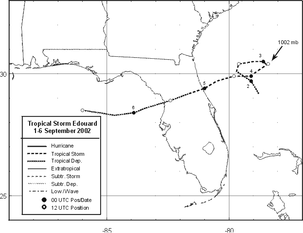
Figure 1:
Best track positions for Tropical Storm Edouard, 1-6 September
2002, with minimum pressure at arrowhead.
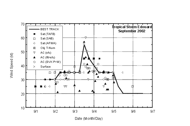
Figure 2:
Selected wind observations and best track maximum sustained
surface wind speed curve for Tropical Storm Edouard, September 2002.
Aircraft observations have been adjusted for elevation using 90%, 80%, and
80% reduction factors for observations from 700 mb, 850 mb, and 1500 ft,
respectively.
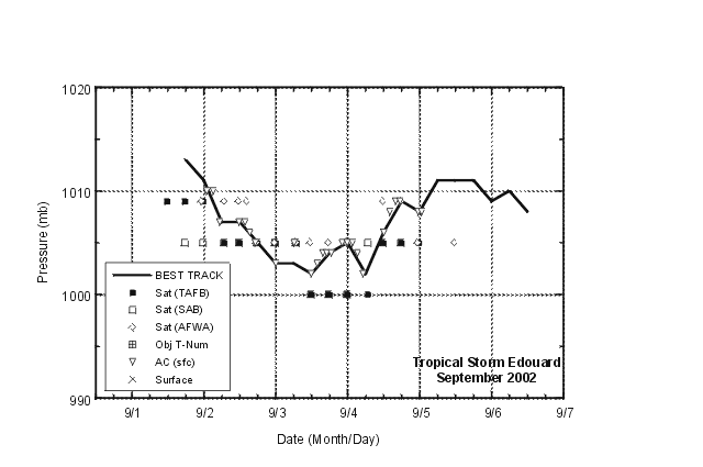
Figure 3:
Selected pressure observations and best track minimum central
pressure curve for Tropical Storm Edouard, September 2002.
|


