The Water Cycle (Water Science for Schools)
The Water Cycle ¦ Water Science for Schools ¦ Contact us ¦ Back
In our section about water storage in the oceans we describe how the oceans act as a large storehouse of water that evaporates to become atmospheric moisture. The oceans are kept full by precipitation and also by runoff and discharge from rivers and the ground. Many people probably have an overly-simplified idea that precipitation falls on the land, flows overland (runoff), and runs into rivers, which then empty into the oceans. That is "overly simplified" because rivers also gain and lose water to the ground. Still, it is true that much of the water in rivers comes directly from runoff from the land surface, which is defined as surface runoff.
 When rain hits saturated or impervious ground it begins to flow overland downhill. It is easy to see if it flows down your driveway to the curb and into a storm sewer, but it is harder to notice it flowing overland in a natural setting. During a heavy rain you might notice small rivulets of water flowing downhill. Water will flow along channels as it moves into larger creeks, streams, and rivers. This picture gives a graphic example of how surface runoff (here flowing off a road) enters a small creek. The runoff in this case is flowing over bare soil and is depositing sediment into the river (not good for water quality). The runoff entering this creek is beginning its journey back to the ocean.
As with all aspects of the water cycle, the interaction between precipitation and surface runoff varies according to time and geography. Similar storms occurring in the Amazon jungle and in the desert Southwest of the United States will produce different surface-runoff effects. Surface runoff is affected by both meteorological factors and the physical geology and topography of the land. Only about a third of the precipitation that falls over land runs off into streams and rivers and is returned to the oceans. The other two-thirds is evaporated, transpired, or soaks (infiltrates) into ground water. Surface runoff can also be diverted by humans for their own uses.
The small creek shown in the picture above will merge with another creek, eventually flowing into a larger river. Thus, this creek is a tributary to a river somewhere downstream, and the water in that river will eventually flow into an ocean. The concept is not that much different from the small capillaries in your body carrying blood to larger arteries, eventually finding its way to your heart, analagous to the ocean.
![]() Type of precipitation (rain, snow, sleet, etc.)
Type of precipitation (rain, snow, sleet, etc.)
![]() Rainfall intensity
Rainfall intensity
![]() Rainfall amount
Rainfall amount
![]() Rainfall duration
Rainfall duration
![]() Distribution of rainfall over the drainage basin
Distribution of rainfall over the drainage basin
![]() Direction of storm movement
Direction of storm movement
![]() Precipitation that occurred earlier and resulting soil moisture
Precipitation that occurred earlier and resulting soil moisture
![]() Other meteorological and climatic conditions that affect evapotranspiration, such as temperature, wind, relative humidity, and season
Other meteorological and climatic conditions that affect evapotranspiration, such as temperature, wind, relative humidity, and season
![]() Land use
Land use
![]() Vegetation
Vegetation
![]() Soil type
Soil type
![]() Drainage area
Drainage area
![]() Basin shape
Basin shape
![]() Elevation
Elevation
![]() Topography, especially the slope of the land
Topography, especially the slope of the land
![]() Drainage network patterns
Drainage network patterns
![]() Ponds, lakes, reservoirs, sinks, etc. in the basin, which prevent or delay runoff from continuing downstream
Ponds, lakes, reservoirs, sinks, etc. in the basin, which prevent or delay runoff from continuing downstream
 As more and more people inhabit the Earth, and as more development and urbanization occur, more of the natural landscape is replaced by impervious surfaces, such as roads, houses, parking lots, and buildings that reduce infiltration of water into the ground and accelerate runoff to ditches and streams. In addition to increasing imperviousness, removal of vegetation and soil, grading the land surface, and constructing drainage networks increase runoff volumes and shorten runoff time into streams from rainfall and snowmelt. As a result, the peak discharge, volume, and frequency of floods increase in nearby streams.
 Urbanization can have a great effect on hydrologic processes, such as surface-runoff patterns. Imagine it this way: in a natural environment, think of the land in the watershed alongside a stream as a sponge (more precisely, as layers of sponges of different porosities) sloping uphill away from the stream. When it rains some water is absorbed into the sponge (infiltration) and some runs off the surface of the sponge into the stream (runoff). Assume a storm lasting one hour occurs and one-half of the rainfall enters the stream and the rest is absorbed by the sponges. Now, gravity is still at play here, so the water in the sponges will start moving in a general downward direction, with most of it seeping out and into the streambanks during the next day or two.
 Next, imagine that roads and buildings have replaced most of the watershed surface. When that one inch of rainfall occurs, it can't infiltrate these impervious surfaces and will runoff directly into the stream, and very quickly, too! The result is a very quick and short-lived urban flood, rather than a gradual rise and fall in the river. Still, a flood lasting even 10 short minutes is enough to ruin your basement.
This concept is illustrated by this hydrograph of a rural (Newaukum Creek - blue line) and an urban (Mercer Creek - green line) creek in Washington State. If you measured the area under both curves (the total volume of water that flowed by the measurement location for the time period shown on the X axis) in the chart, they might be the same. But in the urban stream, the water at the measurement site rose at a much higher rate and reached a much higher stage (height) than the rural stream did. The tall, steep curve of Mercer Creek showed that much higher streamflows occurred in the urban stream. The urban stream stage fell back towards baseflow much quicker, too, indicating that it wasn't receiving much seepage from ground water. The rural stream rose much slower and reached a lower peak, meaning it may not have flooded at all. It took longer to fall back to baseflow as ground water slowly seeped into the streambanks over the next week.
![]() Effects of Urban Development on Floods, USGS Fact Sheet 076-03.
Effects of Urban Development on Floods, USGS Fact Sheet 076-03.
![]() USGS: Surface-water data for the Nation
USGS: Surface-water data for the Nation
![]() USGS:
Real-time streamflow data
USGS:
Real-time streamflow data
![]() USGS: Surface-water information
USGS: Surface-water information
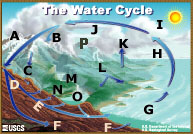 |
A - Storage in ice and snow B - Precipitation C - Snowmelt runoff to streams D - Infiltration E - Ground-water discharge F - Ground-water storage G - Water storage in oceans H - Evaporation |
I - Condensation J - Water storage in the atmosphere K - Evapotranspiration L - Surface runoff M - Streamflow N - Springs O - Freshwater storage P - Sublimation |

![]() U.S. Department of the Interior |
U.S. Geological Survey
U.S. Department of the Interior |
U.S. Geological Survey
URL: http://ga.water.usgs.gov/edu/watercyclerunoff.html
Page Contact Information: Howard Perlman
Page Last Modified: Wednesday, 13-Aug-2008 07:26:58 EDT
