 | |
The water cycle: Ground-water storage | Back • Water-cycle home |
|
| |
The water cycle: Ground-water storage | Back • Water-cycle home |

 Large amounts of water are stored in the ground. The water is still moving, possibly very slowly, and it is still part of the water cycle. Most of the water in the ground comes from precipitation that infiltrates downward from the land surface. The upper layer of the soil is the unsaturated zone, where water is present in varying amounts that change over time, but does not saturate the soil. Below this layer is the saturated zone, where all of the pores, cracks, and spaces between rock particles are saturated with water. The term ground water is used to describe this area. Another term for ground water is "aquifer," although this term is usually used to describe water-bearing formations capable of yielding enough water to supply peoples' uses. Aquifers are a huge storehouse of Earth's water and people all over the world depend on ground water in their daily lives.
The top of the surface where ground water occurs is called the water table. In the diagram, you can see how the ground below the water table is saturated with water (the saturated zone). Aquifers are replenished by the seepage of precipitation that falls on the land, but there are many geologic, meteorologic, topographic, and human factors that determine the extent and rate to which aquifers are refilled with water. Rocks have different porosity and permeability characteristics, which means that water does not move around the same way in all rocks. Thus, the characteristics of ground-water recharge vary all over the world.
 I hope you appreciate my spending an hour in the blazing sun to dig this hole at the beach. It is a great way to illustrate the concept of how at a certain depth the ground, if it is permeable enough to allow water to move through it, is saturated with water. The top of the pool of water in this hole is the water table. The breaking waves of the ocean are just to the right of this hole, and the water level in the hole is the same as the level of the ocean. Of course, the water level here changes by the minute due to the movement of the tides, and as the tide goes up and down, the water level in the hole moves, too. Just as with this hole, the level of the water table is affected by other environmental conditions.
In a way, this hole is like a dug well used to access ground water, albeit saline in this case. But, if this was freshwater, people could grab a bucket an supply themselves with the water they need to live their daily lives. You know that at the beach if you took a bucket and tried to empty this hole, it would refill immediately because the sand is so permeable that water flows easily through it, meaning our "well" is very "high-yielding" (too bad the water is saline). To access freshwater, people have to drill wells deep enough to tap into an aquifer. The well might have to be dozens or thousands of feet deep. But the concept is the same as our well at the beach—access the water in the saturated zone where the voids in the rock are full of water.
 In an aquifer, the soil and rock is saturated with water. If the aquifer is shallow enough and permeable enough to allow water to move through it at a rapid-enough rate, then people can drill wells into it and withdraw water. The level of the water table can naturally change over time due to changes in weather cycles and precipitation patterns, streamflow and geologic changes, and even human-induced changes, such as the increase in impervious surfaces, such as roads and paved areas, on the landscape.
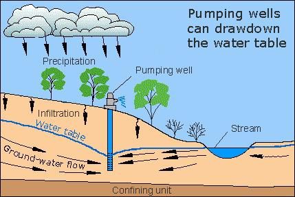
The pumping of wells can have a great deal of influence on water levels below ground, especially in the vicinity of the well, as this diagram shows. If water is withdrawn from the ground at a faster rate that it is replenished by precipitation infiltration and seepage from streams, then the water table can become lower, resulting in a "cone of depression" around the well. Depending on geologic and hydrologic conditions of the aquifer, the impact on the level of the water table can be short-lived or last for decades, and the water level can fall a small amount or many hundreds of feet. Excessive pumping can lower the water table so much that the wells no longer supply water—they can "go dry."
 Ground water occurs only close to the Earth's surface. There must be space between the rock particles for ground water to occur, and the Earth's material becomes denser with more depth. Essentially, the weight of the rocks above condense the rocks below and squeeze out the open pore spaces deeper in the Earth. That is why ground water can only be found within a few miles of the Earth's surface.
As these charts show, even though the amount of water locked up in ground water is a small percentage of all of Earth's water, it represents a large percentage of total freshwater on Earth. The pie chart shows that about 1.7 percent of all of Earth's water is ground water and about 30.1 percent of freshwater on Earth occurs as ground water. As the bar chart shows, about 5,614,000 cubic miles (mi3), or 23,400,000 cubic kilometers (km3), of ground water exist on Earth. About 54 percent is saline, with the remaining 2,526,000 mi3 (10,530,000 km3) , about 46 percent, being freshwater.
 Water in aquifers below the oceans is generally saline, while the water below the land surfaces (where freshwater, which fell as precipitation, infiltrates into the ground) is generally freshwater. There is a stable transition zone that separates saline water and freshwater below ground. It is fortunate for us that the relatively shallow aquifers that people tap with wells contain freshwater, since if we tried to irrigate corn fields with saline water I suspect the stalks would refuse to grow.
| Water source | Water volume, in cubic miles | Water volume, in cubic kilometers | Percent of total water | Percent of total freshwater | |
|---|---|---|---|---|---|
| Fresh ground water | 2,526,000 | 10,530,000 | 0.8% | 30.1% | |
| Ground water | 5,614,000 | 23,400,000 | 1.7% | -- | |
| Total global water | 332,500,000 | 1,386,000,000 | -- | -- | |
| Source: Gleick, P. H., 1996: Water resources. In Encyclopedia of Climate and Weather, ed. by S. H. Schneider, Oxford University Press, New York, vol. 2, pp.817-823. | |||||
♦ Ground Water
and Surface Water A Single Resource, USGS Circular 1139
♦ NASA Earth Observatory; The Water Cycle
♦ USGS Ground Water Atlas of the United States
♦ USGS: Ground-water data for the Nation
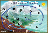 |
A - Storage in ice and snow B - Precipitation C - Snowmelt runoff to streams D - Infiltration E - Ground-water discharge F - Ground-water storage G - Water storage in oceans H - Evaporation |
I - Condensation J - Water storage in the atmosphere K - Evapotranspiration L - Surface runoff M - Streamflow N - Springs O - Freshwater storage P - Sublimation |

![]() U.S. Department of the Interior | U.S. Geological Survey
U.S. Department of the Interior | U.S. Geological Survey
URL: http://ga.water.usgs.gov/edu/watercyclegwstorage.html
Page Contact Information: Howard Perlman
Page Last Modified: Wednesday, 13-Aug-2008 07:25:18 EDT