Earth Features (All Years):
|
 |
|
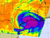
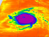
9/13/08 - Ike Roared Ashore in Texas
Hurricane Ike is seen in infrared by NASA's Aqua spacecraft about an
hour after making landfall Sept. 13 in Galveston, Texas.
|
| |
|
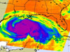
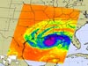
9/12/08 - Ike Begins Battering Gulf Coast
A monstrously large, extremely dangerous Hurricane Ike is already
affecting the Gulf Coast. NASA's Aqua spacecraft took this infrared
image early Sept. 12.
|
| |
|
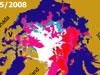
9/11/08 - QuikScat Maps Historic Sea Ice Changes
QuikScat has detected a recent major melting of sea ice (depicted in
red and magenta) that is clearing Arctic sea routes.
|
| |

|
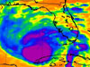
9/11/08 - Ike Advances on the Gulf Coast
A very large and growing Hurricane Ike steams toward the Texas coast
in this Sept. 11 afternoon infrared image from NASA's Aqua spacecraft.
|
| |
|
9/5/08 - September Peak Month for Atlantic Hurricanes
Why is September the peak month for hurricanes? NASA oceanographer Bill Patzert provides some insights.
|
| |

|
9/5/08 - East Coast Braces for Hanna's Arrival
Purples denote Tropical Storm Hanna's strongest winds (left image) and highest, coldest cloud tops (right image) in these Sept. 5 views from NASA's QuikScat and Aqua spacecraft, respectively.
|
| |
|
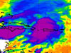
9/4/08 - Unlikable Ike Looms Large
Hurricane Ike marches west in this Sept. 4 early morning infrared image from NASA's Aqua spacecraft. Ike is a compact but powerful storm with maximum sustained winds of 217 kilometers (135 miles) per hour.
|
| |
|
9/3/08 - Hanna and Her Sister
While Tropical Storm Hanna moves toward the Bahamas, in the eastern Atlantic, her younger sister, Tropical Storm Josephine, begins her westward trek in these Sept. 3 infrared images from NASA's Aqua spacecraft.
|
| |

|
9/2/08 - Hanna Goes to Haiti
Tropical Storm Hanna follows in Gustav's footsteps, affecting Haiti and the Dominican Republic in this Sept. 2 afternoon infrared image from NASA's Aqua satellite. Hanna is expected to become a hurricane tomorrow and may affect the entire U.S. eastern seaboard by this weekend.
|
| |
|
9/1/08 - Gustav Grinds Ashore
This Sept. 1 early morning infrared image from NASA's Aqua spacecraft
shows Hurricane Gustav about six hours before the Category Two storm
made landfall in Louisiana.
|
| |
| + Next 10 |