Skip Navigation Linkswww.weather.gov
NOAA logo - Click to go to the NOAA homepage National Weather Service Forecast Office   NWS logo - Click to go to the NWS homepage
WFO Little Rock, Arkansas
Home News Organization  
 
What's New
Local Forecast by City, ST (ex. Cabot, AR) or ZIP
 
Current Hazards
  Watches & Warnings
Submit a Storm Report
Road Reports (U.S.)
Current Conditions
  Observations
Satellite
Rivers & Lakes AHPS
Precip Estimate
Hydrology
Radar Imagery
  Local and National Pictures
Forecasts
  Activity Planner
Local Forecast Page
Aviation Weather
Fire Weather
Tropical Weather
Forecast Tools
Climate
  Local
National
More...
Weather Safety
  Skywarn Page
NOAA Weather Radio
Severe & Winter Weather Guides
Monthly Storm Reports and Storm Data
Special Pages
  Historic Weather Events in Arkansas
The New Technology
Cooperative Observer Program
Community Outreach
About the Office
  Meet the Staff
The Scribe Newsletter
Office Awards
Office Directions
Other Items
  Wind Chill & Heat Index Charts
Sun/Moon Data
Weather Calculator
Weather Shots
List of Weather Web Sites
Contact Us Contact Us
Watches and Warnings
Product Notice
Please check the TIME and DATE of all products!!  Click REFRESH to update page and associated maps.
Watches, Warnings, Advisories in Arkansas and Surrounding States
Directions: Click on map below to look at forecasts/hazards in Arkansas and surrounding states. Click to the right of the map for hazards only.
Click on the map below for the latest forecast. En Español
Last map update: Fri, Sep. 19, 2008 at 11:01:42 pm CDT
Read watches, warnings & advisories.

Zoom
Out

Flood Warning
Hazardous Weather Outlook
Short Term Forecast
Cities in Arkansas Coordinates (make sure "Lon" is negative)
Lat:   Lon:
Text Products Issued for Counties in Arkansas
Text Products Issued for the Little Rock County Warning Area
Latest Severe Thunderstorm Warnings Latest Tornado Warnings
Latest Flash Flood:
Watches / Warnings / Statements
Latest Short Term Forecasts 
Latest Severe Weather Statements Latest Watch County Notification Message
Latest Winter Weather Messages Latest Non-Precipitation Messages
When are these products issued?
Local Storm Reports
 Most Recent Local Storm Reports for Little Rock County Warning Area!!
Recent Local Storm Reports (U.S.)...Graphics and Text!!
Note:  In a report,  time is in "Z" or "Coordinated Universal Time" (subtract 5 hours in Daylight Time or 6 hours in Standard Time...2145Z is 1645  <445pm CDT> or 1545 <345pm CST>).  Size in reports is as follows: tornado is "F" rated (0 "weak" to 5 "violent"), hail is in inches ("075" is .75 inches), wind is in mph. UNK means the size was unknown at the time of the report.   
Recent Reports Including the Little Rock County Warning Area    

These reports are preliminary.  For more official reports (that have appeared or will appear in Storm Data), click here.
 
Watches, Warnings, Advisories and Statements in the U.S.
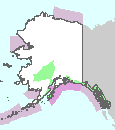
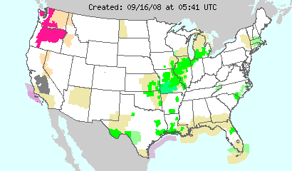
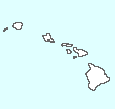
Directions: Click on the map above to go to areas (i.e. National Weather Service websites) where Watches, Warnings, Advisories and Statements (i.e. hazards) exist. For text products describing the hazards, click on a state in the dropdown menu below.

1 - Warnings & Advisories
2 - Watches
3 - Hazardous Weather Outlooks/Special Weather Statements
4 - Short Term Forecasts
Convective Outlooks (U.S.)
Day 1 (Today/Tonight) | Day 2 (Tomorrow/Tomorrow Night)
Note:  General thunder (non-severe) is to the right of each brown line, a slight risk of severe thunderstorms is in green, a moderate risk is in red and a high risk is in pink.
A Look Ahead: Day 3 | Days 4-8


National Weather Service
Little Rock Weather Forecast Office
Page last modified: 15 September, 2008
Disclaimer

Credits

Glossary
Privacy Policy

About Our Organization

Career Opportunities