Skip Navigation Linkswww.weather.gov
NOAA logo - Click to go to the NOAA homepage National Weather Service Forecast Office   NWS logo - Click to go to the NWS homepage
WFO Little Rock, Arkansas
Home News Organization  
 
What's New
Local Forecast by City, ST (ex. Cabot, AR) or ZIP
 
Current Hazards
  Watches & Warnings
Submit a Storm Report
Road Reports (U.S.)
Current Conditions
  Observations
Satellite
Rivers & Lakes AHPS
Precip Estimate
Hydrology
Radar Imagery
  Local and National Pictures
Forecasts
  Activity Planner
Local Forecast Page
Aviation Weather
Fire Weather
Tropical Weather
Forecast Tools
Climate
  Local
National
More...
Weather Safety
  Skywarn Page
NOAA Weather Radio
Severe & Winter Weather Guides
Monthly Storm Reports and Storm Data
Special Pages
  Historic Weather Events in Arkansas
The New Technology
Cooperative Observer Program
Community Outreach
About the Office
  Meet the Staff
The Scribe Newsletter
Office Awards
Office Directions
Other Items
  Wind Chill & Heat Index Charts
Sun/Moon Data
Weather Calculator
Weather Shots
List of Weather Web Sites
Contact Us Contact Us
Interactive Forecast Preparation System (IFPS)
IFPS
Forecasters at the National Weather Service are using the Interactive Forecast Preparation System (IFPS) to create a whole new suite of forecast products. For more information, look below.  
National Digital Forecast Database (NDFD)
National Digital Forecast Database logo The demand for more detailed forecast information is increasing. The Interactive Forecast Preparation System (IFPS) is helping the National Weather Service meet these demands, with the capability to create a powerful set of forecast grids.
Each grid is like a package containing weather information (i.e. temperature, wind, cloud cover, precipitation, etc) for a small area. When put together like pieces of a puzzle, these grids make up the National Digital Forecast Database (NDFD). The NDFD has a world of possibilities, with small scale or larger scale products made available in both text and graphical formats.

Check It Out!   

Graphical Forecast


Graphical forecasts are generated through the NDFD for each National Weather Service County Warning Area (CWA)...including the Little Rock CWA (as shown to right). A probability of precipitation (POP) graphic for the Little Rock County Warning Area (CWA).
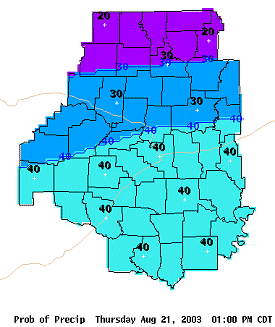
In the picture: A probability of precipitation (POP) graphic for the Little Rock County Warning Area (CWA).
 
When put together (as a mosaic), the graphics for the National Weather Service CWAs (122 of them) become a seamless national graphical forecast.

Check It Out! 

 
Point Forecast
 
A county versus point forecast perspective. Up until the NDFD, forecasts were created on a county by county basis. With small forecast grids available, now forecasts can be made for points within counties! 
In the picture: A county versus point forecast perspective.
 
As an illustration, try the county forecast and point forecast drop-down menus below. You'll notice that point forecasts are for specific latitudes and longitudes.
 

Now try a point forecast...which is made for specific latitudes and longitudes (a much smaller scale). In addition to a 7-day forecast, there is also a meteogram and tabular data available for each point.
 
Cities in Arkansas Coordinates (make sure "Lon" is negative)
Lat:   Lon:
 

Check It Out!

Tabular Forecast
 
As mentioned in the "Point Forecast" section, the National Weather Service is creating new text (tabular) products. 
 
A piece of a Tabular Point Forecast.
In the picture: A piece of a Tabular Point Forecast.
 
The Tabular Point Forecast, for example, is a very specific forecast of expected weather conditions in 3 hour increments.   
 

Check It Out!


National Weather Service
Little Rock Weather Forecast Office
Page last modified: 13 November, 2007
Disclaimer

Credits

Glossary
Privacy Policy

About Our Organization

Career Opportunities