
Unified Interior Regions
Region 4: Mississippi Basin
Regions L2 Landing Page Tabs
Welcome to the Mississippi Basin Region! Our streamgage network is used to monitor and assess water resources across the region. Other research focuses on fisheries and aquatic ecosystems, midcontinental plant/animal species, invasive species, wildlife disease, and energy and mining.
News
")
USGS: Delta will erode parts of Louisiana, Texas coasts
Editor’s note: This story updates and replaces a story published October 8, reflecting a new forecast that reduces the extent of Hurricane Delta’s impacts on central Gulf Coast sandy shorelines.
To learn more about USGS’s role in providing science to decision makers before, during and after Hurricane Delta, visit www.usgs.gov/delta

USGS Deploying Storm Tide Sensors Along Gulf Coast for Hurricane Delta
To learn more about USGS’s role in providing science to decision-makers before, during and after Hurricane Delta, visit the USGS Hurricane Delta page at www.usgs.gov/delta.

USGS Science to Keep Us Safe: Floods and Drought
The scarcity or overabundance of water presents some of the most dangerous, damaging and costly threats to human life, ecosystems and property in the form of drought, floods and debris flows.
Publications

Movement of synthetic organic compounds in the food web after the introduction of invasive quagga mussels (Dreissena bugensis) in Lake Mead, Nevada and Arizona, USA
Introductions of dreissenid mussels in North America have been a significant concern over the last few decades. This study assessed the distribution of synthetic organic compounds (SOCs) in the food web of Lake Mead, Nevada/Arizona, USA and how this distribution was influenced by the introduction of invasive quagga mussels. A clear spatial...
Goodbred, Steven L.; Rosen, Michael R.; Patino, Reynaldo; Alvarez, David; Echols, Kathy R.; King, Kerensa; Umek, John
Water resources of Pointe Coupee Parish, Louisiana
Information concerning the availability, use, and quality of water in Pointe Coupee Parish, Louisiana, is critical for proper water-supply management. The purpose of this fact sheet is to present information that can be used by water managers, parish residents, and others for stewardship of this vital resource. In 2014, 364 million gallons per day...
White, Vincent E.
Considerations for incorporating quality control into water quality sampling strategies for the U.S. Geological Survey
This report describes considerations for incorporating routine quality-assessment and quality-control evaluations into U.S. Geological Survey discrete water-sampling programs and projects. U.S. Geological Survey water-data science in 2020 is characterized by robustness, external reproducibility, collaborative large-volume data analysis, and...
Medalie, Laura and copper (right) exposed fish")
Behavioral Toxicology Laboratory
The Behavioral Toxicology Laboratory develops behavioral methods in aquatic toxicology. These assays are used to characterize and quantify effects of contaminants on aquatic organisms. They have utilized these methods with a variety of organisms including larval and juvenile fish and amphibians.

Forest Structure Resulting from ‘Wildlife Forestry Silviculture’
Wildlife forestry is management of forest resources, within sites and across landscapes, to provide sustainable, desirable habitat conditions for all forest-dependent (silvicolous) fauna while concurrently yielding economically viable, quality timber products. In practice, however, management decisions associated with wildlife forestry often reflect a desire to provide suitable habitat for...

Mapping High Marsh along the Northern Gulf of Mexico Coast
USGS is collaborating with Mississippi State University to investigate the effects of fire on Gulf of Mexico marshes. The project will include mapping high marsh and monitoring black rail, yellow rail, and mottled duck responses to prescribed fire application.

Creating a System-Wide Assessment and Monitoring Program (SWAMP) for Coastal Louisiana
USGS researchers will provide technical guidance to inform the development of monitoring plans for the western coast of Louisiana.
Louisiana Public Awareness, Hydrologic Studies, and Hydrologic Data
Louisiana Public Awareness, Hydrologic Studies, and Hydrologic Data

Ozark Dome-Arkoma Basin-Ouachita Transect
The Ozark Dome-Arkoma Basin-Ouachita Transect (ODABOuT) project examines the three-dimensional geology of a transect of the southern orogenic margin of North America in its best surface exposure in western Arkansas. The Ozark Dome and Arkoma Basin represent a foreland uplift and foreland basin that formed as a result of the impinging Ouachita orogenic belt. Understanding the geometry and...

Real-Time Storm Response
Coastal change forecasts and pre- and post-storm photos documenting coastal change for landfalling storms. Currently responding to Hurricane Dorian.

Gulf Coast Ecosystem Restoration Council Monitoring and Assessment Program Development
The National Oceanic and Atmospheric Administration (NOAA) and USGS will jointly lead the development of foundational components for Gulf region-wide monitoring.

Contact Us
<div class="pane-content">
<div class="field field-name-og-group-ref field-type-entityreference field-label-hidden"><div class="field-items"><div class="field-item even"><a href="/centers/lmg-water">Lower Mississippi-Gulf Water Science Center</a></div></div></div> </div>
</div>

Geospatially Enabled, Web-based Habitat Reporting Tool to Support Monitoring and Assessment along the Louisiana Shore
The State of Louisiana's Barrier Island Comprehensive Monitoring (BICM) program has partnered with USGS to developed two habitat classifications schemes for monitoring barrier island habitats and habitats in beach-dune systems along the mainland. These schemes builds upon previous BICM habitat mapping efforts.

Model Improvements for Louisiana’s 2023 Coastal Master Plan
The Louisiana Coastal Protection and Restoration Authority’s Coastal Master Plan is a blueprint for responding to environmental changes. As part of the agency’s continued engagement, USGS supports model developments and improvements for the 2023 Coastal Master Plan.
 - Black (TM)")
Geochemical analyses of bauxite and associated rocks from the Arkansas bauxite region, central Arkansas
This data release compiles major and trace element analytical results of samples of bauxite (aluminum ore) and associated rocks collected from the Arkansas bauxite region, located near the center of Arkansas in Pulaski and Saline Counties. Samples were collected by the U.S. Geological Survey (USGS) in April 2018 as part of the USGS' focus on increased understanding of the United State

Suspended-sediment concentration data from water samples collected in 2016-17 in Grand Bay, Alabama and Mississippi
In wetlands within and near Grand Bay National Estuarine Research Reserve, parts of the salt marsh are eroding relatively rapidly. To understand the connection between sediment fluxes and these processes, the U.S. Geological Survey made oceanographic and water-quality measurements from August 2, 2016, to January 28, 2017
Airborne magnetic and radiometric survey, southeast Missouri and western Illinois, 2018-2019
This publication provides digital flight line data for a high-resolution horizontal magnetic gradient and radiometric survey over an area of southeast Missouri and western Illinois. The survey represents the first airborne geophysical survey conducted as part of the U.S. Geological Survey (USGS) Earth Mapping Resource Initiative (Earth MRI) effort (Day, 2019). Earth MRI is a coopera
Geochemical data supporting a comparison of apatite between regional magmatism and the Pea Ridge Iron Oxide-Apatite-Rare Earth Element (IOA-REE) and Boss Iron Oxide-Copper-Cobalt-Gold-REE Deposits (IOCG) deposits, southeastern Missouri, USA
This data release presents high-spatial resolution geochemical analyses collected from Mesoproterozoic apatite crystals in igneous rocks from the St. Francois Mountains terrane and coeval ore rocks from the Pea Ridge iron oxide-apatite-rare earth element (IOA-REE) and Boss iron oxide-copper-gold (IOCG) deposits. These deposits are located in the southeast Missouri iron metallogenic provin
Archive of Chirp Subbottom Profile Data Collected in 2018 from the Northern Chandeleur Islands, Louisiana
From August 16 to 21, 2018, the U.S. Geological Survey (USGS) conducted a geophysical survey to investigate the geologic controls on barrier island evolution and medium-term and interannual sediment transport along the sand berm constructed in 2011 (offshore, at the northern end of the Chandeleur Islands, Louisiana) as mitigation of the Deepwater Horizon oil spill. This investigat
Channel bed elevations for a 5-mile reach on the Maumelle River upstream of Lake Maumelle near Little Rock, Arkansas, 2019
The U.S. Geological Survey (USGS) in cooperation with the U.S. Army Corps of Engineers (USACE) did a bathymetric survey of the lower reach of the Maumelle River upstream of Lake Maumelle, near Little Rock, Arkansas, from July 9—11, 2019. Channel bed elevations (thalweg) were collected to support a USACE modeling effort on a 5-mile reach of the Maumelle River. In parts
USGS Gulf Coast Petroleum Systems and National and Global Oil and Gas Assessment Projects-Louisiana-Mississippi Salt Basins and Western Gulf Provinces, Upper Cretaceous Tuscaloosa Marine Shale Assessment Unit Boundaries and Assessment Input Data Forms
This data release contains the boundaries of assessment units and input data for the assessment of undiscovered gas hydrate resources on the north slope of Alaska. The Assessment Unit is the fundamental unit used in the National Assessment Project for the assessment of undiscovered oil and gas resources. The Assessment Unit is defined within the context of the higher-level Total Petroleum...
Airborne electromagnetic, magnetic, and radiometric survey, Shellmound, Mississippi, March 2018
Airborne electromagnetic (AEM), magnetic, and radiometric data were acquired in late February to early March 2018 along 2,364 line-kilometers in the Shellmound, Mississippi study area. Data were acquired by CGG Canada Services, Ltd. with three different helicopter-borne sensors: the CGG Canada Services, Ltd. RESOLVE frequency-domain AEM instrument that is used to map subsurface
Crustal Architecture Beneath the Southern Midcontinent (USA) -- Data Grids and 3D Geophysical Models
Regional grid files and 3D voxel models were used to study crustal architecture beneath the Southern Midcontinent (USA) by McCafferty and others (2019). The study covered a rectangular, multi-state area of 924 by 924 kilometers centered on Missouri, and a corresponding volume extending from the topographic surface to a depth of 50 kilometers below sea level. The grid files consist of
Ground-based time-domain electromagnetic data and resistivity models for the Mississippi Alluvial Plain Project
The Mississippi Alluvial Plain (MAP) Project contains several geologic units which act as important aquifers. We collected several sets of time-domain electromagnetic (TEM) data consisting of two higher-density surveys and six regional-scale transects. The higher density surveys were collected to compare and contrast to other geophysical data not included in this data release, such as a

Coastal and Marine Geoscience Data System
Information about scientific data collected through field activities conducted by scientists in the USGS Coastal and Marine Hazards and Resources program

National Water Information System (NWIS) Mapper
The NWIS mapper provides access to over 1.5 million sites contained in the USGS National Water Information System (NWIS), including sites where current and historical surface-water, groundwater, springs, and atmospheric data has been collected. Users can search by site type, data type, site number, or place.

This map shows the provinces assessed by the USGS for undiscovered oil and gas resources.

Louisiana Fact Sheets by Parish

Shreveport Area—Caddo and Bossier Parishes Flood Map

Ascension Parish

Amite River Basin

River and Coastal Forecast Information
Lower Mississippi River Forecast Center, Slidell, Louisiana—(NWS)

Network wells depicted on the Climate Response Network location map
Note: Color shading in the table below indicates multiple wells that plot as a single point on the state location map above.
Note: BLS = Water Level in Feet Below Land Surface, RVD = Water Level referenced to a vertical datum

June 1 marks the beginning of hurricane season. Should storms arrive on the Louisiana coast, the people in coastal communities across the State, along with many Federal, State, and local agencies will need to know how the storms are affecting the coastal and low-lying areas.The USGS maintains an extensive network of coastal gages that provides critical time-sensitive water level.

Real-time displays of current floating conditions at various sites along the Arkansas Buffalo River.

Subsurface geometry of the Mississippi Embayment Regional Aquifer Study (MERAS)

The 3DEP products and services available through The National Map consist of standard digital elevation models (DEMs) at various horizontal resolutions, elevation source and associated datasets, an elevation point query service and bulk point query service. All 3DEP products are available, free of charge and without use restrictions.

The Arkansas Groundwater - Quality Network is a web map interface that provides rapid access to the U.S. Geological Survey's (USGS) NWIS and the U.S. Environmental Protection Agency's (EPA) STORET databases of ambient groundwater information. The interface enables users to perform simple graphical analysis and download selected water-quality data.
Movement of synthetic organic compounds in the food web after the introduction of invasive quagga mussels (Dreissena bugensis) in Lake Mead, Nevada and Arizona, USA
Introductions of dreissenid mussels in North America have been a significant concern over the last few decades. This study assessed the distribution of synthetic organic compounds (SOCs) in the food web of Lake Mead, Nevada/Arizona, USA and how this distribution was influenced by the introduction of invasive quagga mussels. A clear spatial...
Goodbred, Steven L.; Rosen, Michael R.; Patino, Reynaldo; Alvarez, David; Echols, Kathy R.; King, Kerensa; Umek, John Water resources of Pointe Coupee Parish, Louisiana
Information concerning the availability, use, and quality of water in Pointe Coupee Parish, Louisiana, is critical for proper water-supply management. The purpose of this fact sheet is to present information that can be used by water managers, parish residents, and others for stewardship of this vital resource. In 2014, 364 million gallons per day...
White, Vincent E. Considerations for incorporating quality control into water quality sampling strategies for the U.S. Geological Survey
This report describes considerations for incorporating routine quality-assessment and quality-control evaluations into U.S. Geological Survey discrete water-sampling programs and projects. U.S. Geological Survey water-data science in 2020 is characterized by robustness, external reproducibility, collaborative large-volume data analysis, and...
Medalie, Laura
Quality of data from the U.S. Geological Survey National Water Quality Network for water years 2013–17
Water samples from 122 sites in the U.S. Geological Survey National Water Quality Network were collected in 2013–17 to document ambient water-quality conditions in surface water of the United States and to determine status and trends of loads and concentrations for nutrients, contaminants, and sediment to estuaries and streams. Quality-control (QC...
Medalie, Laura; Bexfield, Laura M.
Water levels and selected water-quality conditions in the Mississippi River Valley alluvial aquifer in eastern Arkansas, 2014
In 2014, the U.S. Geological Survey, in cooperation with the Arkansas Geological Survey and the Arkansas Natural Resources Commission, determined water-level altitudes in 468 wells in eastern Arkansas and collected water-quality samples from 144 wells. Water-level altitudes were calculated based on the measured depth to water in each well and used...
Rodgers, Kirk D.; Whaling, Amanda R. An analysis of streamflow trends in the southern and southeastern US from 1950-2015
In this article, the mean daily streamflow at 139 streamflow-gaging stations (sites) in the southern and southeastern United States are analyzed for spatial and temporal patterns. One hundred and thirty-nine individual time-series of mean daily streamflow were reduced to five aggregated time series of Z scores for clusters of sites with similar...
Rodgers, Kirk D.; Roland II, Victor L.; Hoos, Anne B.; Crowley-Ornelas, Elena; Knight, Rodney
Predicted pH of groundwater in the Mississippi River Valley alluvial and Claiborne aquifers, south-central United States
Regional aquifers in the Mississippi embayment are the principal sources of water used for public and domestic supply, irrigation, and industrial uses throughout the region. An understanding of how water quality varies spatially, temporally, and with depth are critical aspects to ensuring long-term sustainable use of these resources. A boosted...
Kingsbury, James A.; Knierim, Katherine J.; Haugh, Connor J. Small mammal responses to wetland restoration in the Greater Everglades ecosystem
Wetlands have experienced dramatic losses in extent around the world, disrupting ecosystem function, habitat, and biodiversity. In Florida’s Greater Everglades, a massive restoration effort costing billions of dollars and spanning multiple decades is underway. As Everglades restoration is implemented in incremental projects, scientists and...
Romanach, Stephanie; D'Acunto, Laura; Chapman, Julia; Hanson, Matthew R A comparison of plant communities in restored, old field, and remnant coastal prairies
Temperate grasslands are experiencing worldwide declines due to habitat conversion. Grassland restoration efforts are employed to compensate for these losses. However, there is a need to better understand the ecological effects of grassland restoration and management practices. We investigated the effects of three different grassland management...
Feher, Laura; Allain, Larry; Osland, Michael; Pigott, Elisabeth; Reid, Christopher; Latiolais, Nicholas Stable isotope dynamics of herbivorous reef fishes and their ectoparasites
Acanthurids (surgeonfishes) are an abundant and diverse group of herbivorous fishes on coral reefs. While their contribution to trophic linkages and dynamics in coral reef systems has received considerable attention, the role of linkages involving their parasites has not. As both consumers of fish tissue and prey to microcarnivores, external...
Jenkins, William; Demopoulos, Amanda; Nicholson, Matthew C.; Sikkel, Paul C. Identifying turbulence features hindering swimming capabilities of grass carp larvae (Ctenopharyngodon idella) through submerged vegetation
Aquatic vegetation can provide habitat and refuge for a variety of species in streams. However, the flow features generated by submerged patches of vegetation can also pose a challenge for fish larvae. We conducted a series of experiments with live grass carp larvae (starting ∼50 h post hatch) in a laboratory racetrack flume, using a submerged...
Tinoco, Rafael O.; Prada, Andres F.; George, Amy E.; Stahlschmidt, Benjamin H.; Jackson, P. Ryan; Chapman, Duane C. Stress gradients interact with disturbance to reveal alternative states in salt marsh: Multivariate resilience at the landscape scale
Stress gradients influence many ecosystem processes and properties, including ecosystem recovery from and resistance to disturbance. While recent analytical approaches have advanced multivariate metrics of ecosystem resilience that allow quantification of conceptual resilience models and identification of thresholds of state change, these...
Jones, Scott; Stagg, Camille; Yando, Erik S.; James, W. Ryan; Buffington, Kevin J.; Hester, Mark W.
In 1977, the Congress of the United States recognized the need for uniform, current, and reliable information on water use and directed the U.S. Geological Survey (USGS) to establish a National Water-Use Information Program (NWUIP) to complement the Survey's data on the availability and quality of the Nations water resources.

Water Well Constrution Reports entered online.

Outstanding in the Field (Ep 4): Amphibian Surveys – Call of the Frog
The USGS Ecosystems Mission Area brings you Outstanding in the Field, a series of stories about our science, our adventures, and our efforts to better understand our fish and wildlife and the ecosystems that support them. In this episode we describe the USGS’s efforts to track frog populations in the southeast United States.

Barry's wave, surge likely to affect beaches in four states
This Coastal Change Storm Hazard Team map was created Friday, July 12, 2019 and shows forecast beach erosion (the strip of colored bars closest to the coast), overwash (middle strip) and inundation (outer strip) effects of Tropical Storm Barry’s predicted landfall in Louisiana. See https://marine.
...
Variable Warming Upper Midwest Lakes and Implications for Sport Fish
Climate change is predicted to alter sport fish communities in Midwestern lakes, but managers currently have limited information on individual lakes that can be used to set local expectations or intervene with mitigation strategies. Northeast and North Central CASC supported researchers, with strong participation from the Midwest Glacial Lakes Partnership, have combined

Testing New Drone Technology to Measure Floodwaters
A USGS crew used new drone technology to test and evaluate new technology to measure water speed from the air without touching the water. This drone footage was taken on the Missouri River at Hermann, Missouri on March 27, 2019. Scientists compared these new method results to the conventional way of taking measurements from a boat.
This work is a part of a national

USGS crews respond to flooding on the Big Sioux River
USGS technician Chris Broz helps take water measurements on the Big Sioux River during record flooding in March, 2019.

Spring 2019 Flooding - Big Sioux River, Akron, IA
After record flooding on the Big Sioux River, USGS crews mobilized to take important water measurements.

Spring 2019 Flooding - Big Sioux River, Hawarden, IA
After record flooding on the Big Sioux River, USGS crews mobilized to take important water measurements.

Spring 2019 Flooding - Big Sioux River
After record flooding on the Big Sioux River, USGS crews mobilized to take important water measurements.

National Oil and Gas Assessment Provinces
This is a graphic from the USGS National Oil and Gas Assessment Explorer application, which allows user to drill into 70 oil and gas assessment provinces throughout the United States.

Aerial photograph looking southwest along Breton Island, Louisiana
Aerial photograph looking southwest along Breton Island, Louisiana, taken July 2013
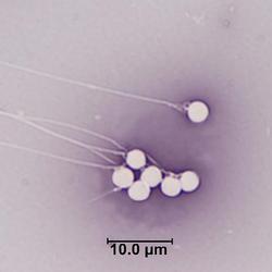
Eosin-nigrosin staining of spermatozoa from common carp
Eosin-nigrosin staining of spermatozoa from common carp (Cyprinus carpio) testes collected from the Lake Mead National Recreation Area, Nevada
Editor’s note: This story updates and replaces a story published October 8, reflecting a new forecast that reduces the extent of Hurricane Delta’s impacts on central Gulf Coast sandy shorelines.
To learn more about USGS’s role in providing science to decision makers before, during and after Hurricane Delta, visit www.usgs.gov/delta
To learn more about USGS’s role in providing science to decision-makers before, during and after Hurricane Delta, visit the USGS Hurricane Delta page at www.usgs.gov/delta.
The scarcity or overabundance of water presents some of the most dangerous, damaging and costly threats to human life, ecosystems and property in the form of drought, floods and debris flows.

To learn more about USGS’s role in providing science to decision makers before, during and after Hurricane Laura, visit www.usgs.gov/laura
U.S. Geological Survey field crews are measuring flooding across the country as spring weather is in full swing. Warming temperatures, increased precipitation and snowmelt have caused moderate to major flooding in the upper Midwest, East Coast, Central Plains and the Southeast portions of the country.

Budget Focuses on Bringing Science, Facilities, and Infrastructure into the 21st Century

New Phase of USGS Low-level Surveys Begins in November

Editor: In the public interest and in accordance with the Federal Aviation Administration regulations, the USGS is announcing this low-level airborne project. Your assistance in informing the local communities is appreciated.

Though Louisiana landfall is likely, highest waves expected to strike east of the storm

NOAA's annual prediction based on USGS data

Reporters: Do you want to accompany a USGS field crew as they inspect high-water marks? Please contact Marisa Lubeck or Paul Rydlund.

Media: Please join the U.S. Geological Survey, CGG Airborne and various partners for a demonstration of the low-flying helicopter and description of what scientists are seeking in and around the Mississippi Alluvial Plain.
Contacts
Locations

Region 4: Mississippi Basin

Fork Polk Project Office
Phone: (337) 531-4522 Fax:
Fax: (337) 531-6039

Louisiana Water Science Center
Phone: (225) 298-5481
Fax: (225) 298-5490
Arkansas Water Science Center
Phone: (501) 228-3600
Fax: (501) 228-3601

Ruston Program Office
Phone: (318) 251-9630
Fax: (318) 251-0372

Missouri Water Science Center
Phone: 573-308-3667
Fax: (573) 308-3645

National Geospatial Technical Operations Center - Rolla, MO
Lower Mississippi-Gulf Water Science Center - Little Rock, AR Office
Phone: (501) 228-3600

Lower Mississippi-Gulf Water Science Center - Jackson, MS Office
Phone: (601) 933-2900
Fax: (601) 933-2901
Lower Mississippi-Gulf Water Science Center - Baton Rouge, LA Office
Phone: (225) 298-5481
Fax: (225) 298-5490

Wetland and Aquatic Research Center - Lafayette, LA
Phone: 337-266-8500
Fax: 337-266-8513

Columbia Environmental Research Center
Phone: 573-875-5399

Iowa Water Science Center
Phone: 319-337-4191
Fax: (319) 358-3606

Western Iowa Field Office - Council Bluffs
Phone: 712-323-0824
Fax: 712-322-7775
Central Iowa Field Office - Fort Dodge
Phone: 515-576-4571
Fax: 515-576-1692
")
Lower Mississippi-Gulf Water Science Center - Ruston, LA Office
Phone: (318) 251-9630

Lower Mississippi-Gulf Water Science Center - Fayetteville, AR Office
Phone: (479) 442-4888
Western Missouri Field Office - Lee's Summit
Phone: 816-554-3489
Fax: 816-554-9273
Eastern Missouri - Olivette
Phone: 314-567-7077 or 314-567-5440
Fax: 314-567-7641
