
3D Elevation Program
Home
To respond to growing needs for high-quality elevation data, the goal of 3DEP is to complete acquisition of nationwide lidar (IfSAR in AK) by 2023 to provide the first-ever national baseline of consistent high-resolution topographic elevation data – both bare earth and 3D point clouds – collected in a timeframe of less than a decade.
Data Download and Visualization
The National Map Data Download, Applications, & Visualization Services
Access DataBroad Agency Announcement (BAA)

The BAA provides detailed information on how to partner with the USGS and other Federal agencies to acquire high-quality 3D Elevation data.
BAA PortalNews
 data")
FY21 U.S. Geological Survey Broad Agency Announcement for 3D Elevation Program Released
https://usgs.gov/3DEP/BAAThe USGS has issued the Fiscal Year 20/21 Broad Agency Announcement (BAA) for the 3D Elevation Program.

Earth MRI Funds Critical Minerals Projects in Twenty-One States
The U.S. Geological Survey and the Association of American State Geologists are pleased to announce the projects that have received funding for FY2020 under the USGS Mineral Resources Program’s Earth Mapping Resources Initiative, or Earth MRI. New projects in 21 states will receive $7.97 million in funding in fiscal year 2020 to improve the Nation’s mapping of shallow and deep geology.

Multiagency Initiative Begins Work on Critical Minerals and Geothermal Energy Research in Nevada
A multiagency partnership led by the USGS and the Department of Energy seeks to shed light on lithium and other critical mineral resource potential as well as geothermal energy potential in western Nevada
Publications

The 3D Elevation Program and energy for the Nation
High-resolution light detection and ranging (lidar) data are used in energy infrastructure siting, design, permitting, construction, and monitoring to promote public safety through the reduction of risks. For example, lidar data are used to identify safe locations for energy infrastructure by analyzing terrain parameters and identifying and...
Thatcher, Cindy A.; Lukas, Vicki; Stoker, Jason M.
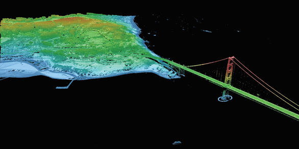
The National Map—New data delivery homepage, advanced viewer, lidar visualization
As one of the cornerstones of the U.S. Geological Survey’s (USGS) National Geospatial Program, The National Map is a collaborative effort among the USGS and other Federal, State, and local partners to improve and deliver topographic information for the Nation. The National Map is featuring direct links to new and improved GIS data access utilities...
The 3D Elevation Program—Supporting California's Economy
IntroductionCalifornia faces unprecedented challenges presented by shifting weather patterns that are defining a “new normal.” The result has been extreme weather events, prolonged drought, flooding, and debris flows. These conditions drive severe tree mortality, increase wildfire occurrence and intensity, reduce water availability, and hasten...
Ostergren, Carol L.; Decker, Drew; Carswell,, William J.