


National Forecast Charts Legacy Page:
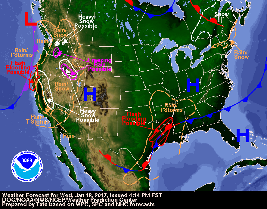
Valid Wed Jan 18, 2017
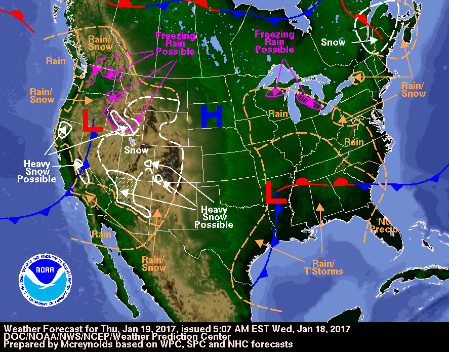
Valid Thu Jan 19, 2017
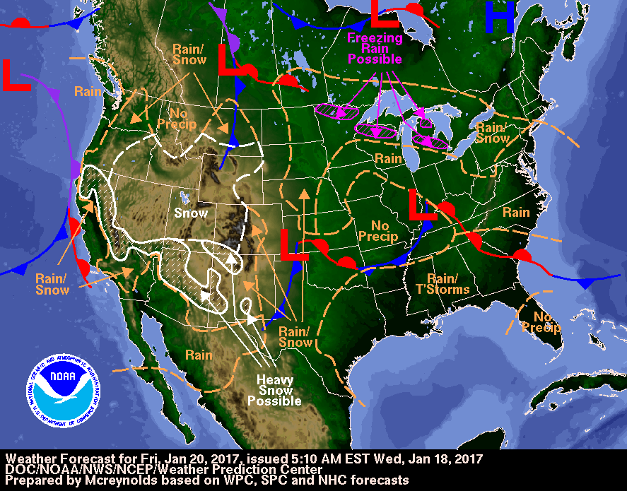
Valid Fri Jan 20, 2017

Image Format:
+ Additional Links
- » Description of the National Forecast Chart
- » Product Archives
- » Download hazards in KML or shapefile format


North American Surface Analysis Legacy Page:
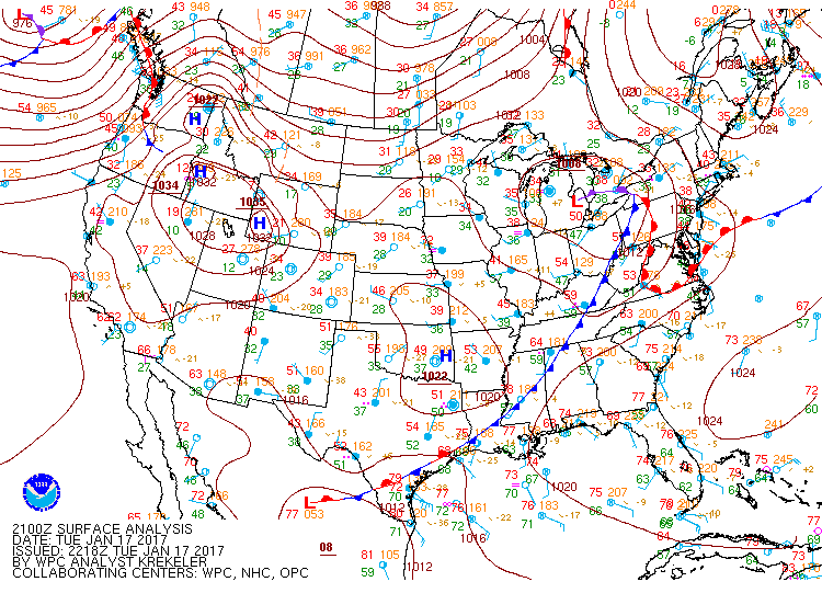
Analyzed at 21Z Tue Jan 17, 2017
Analyzed at 00Z Wed Jan 18, 2017
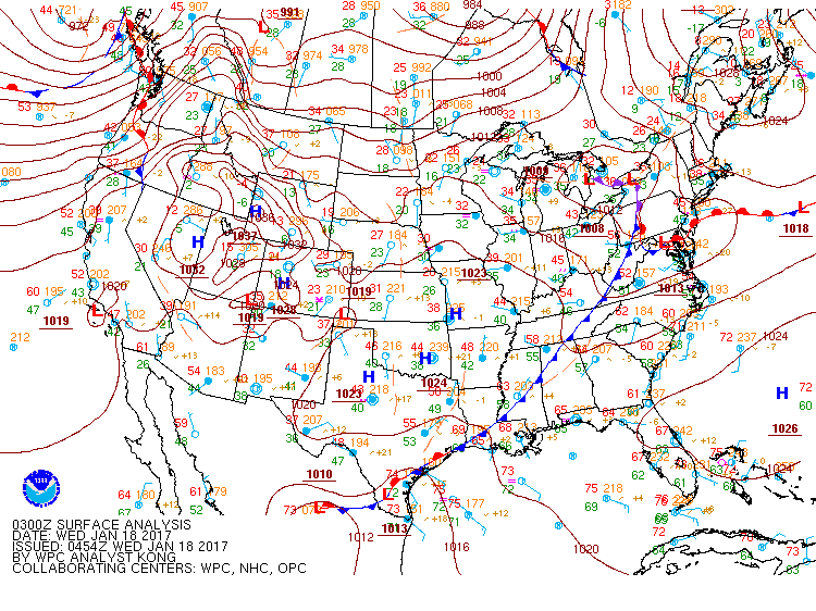
Analyzed at 03Z Wed Jan 18, 2017
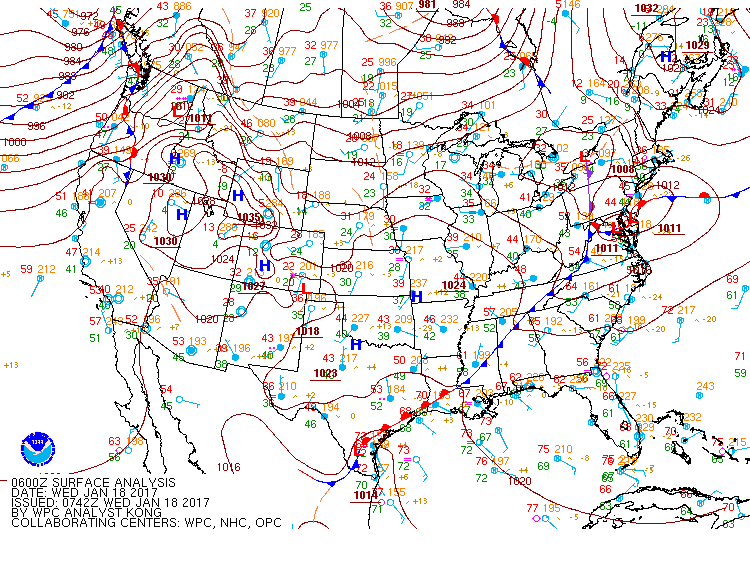
Analyzed at 06Z Wed Jan 18, 2017
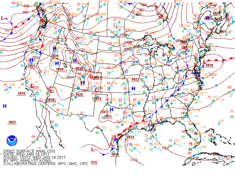
Analyzed at 09Z Wed Jan 18, 2017
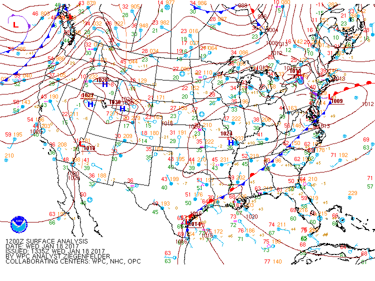
Analyzed at 12Z Wed Jan 18, 2017
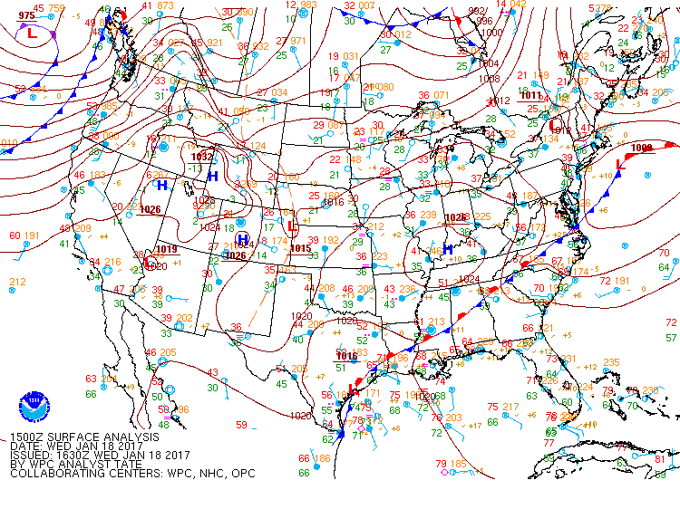
Analyzed at 15Z Wed Jan 18, 2017
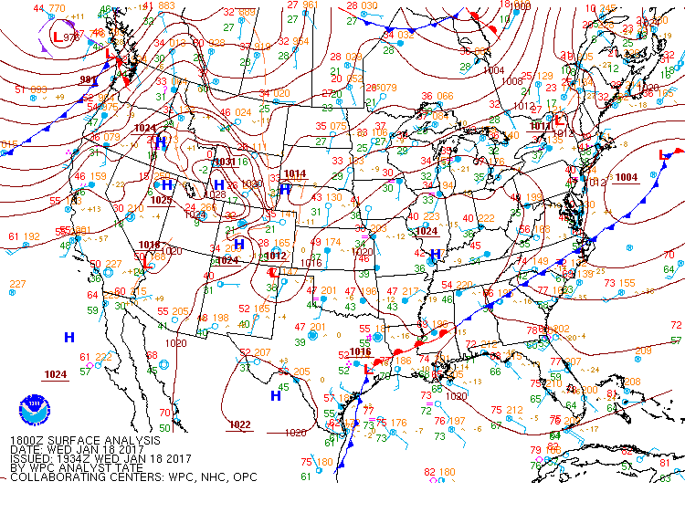
Analyzed at 18Z Wed Jan 18, 2017
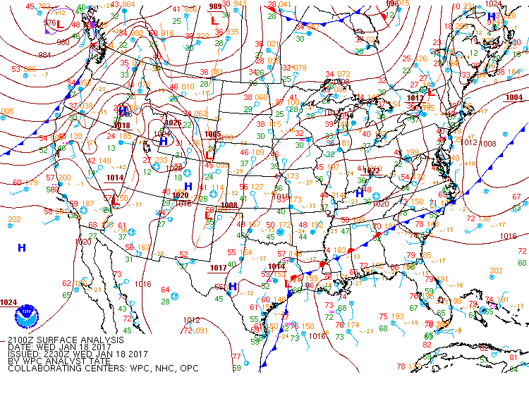
Analyzed at 21Z Wed Jan 18, 2017
Image Format:

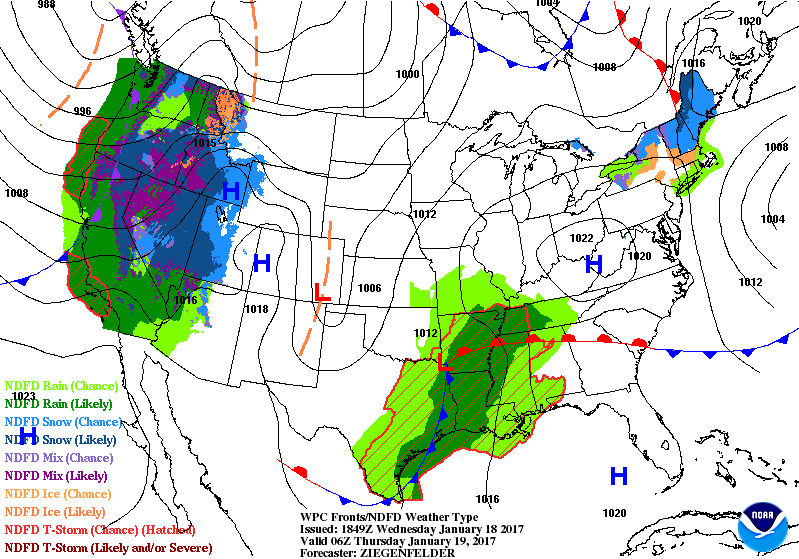
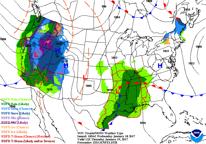
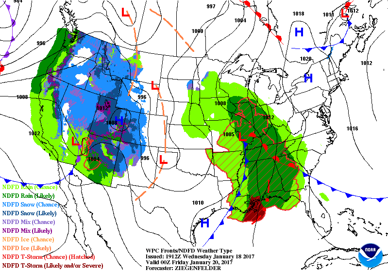
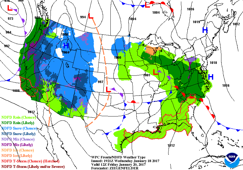
Surface Fronts and Sea-Level Pressures Legacy Page:
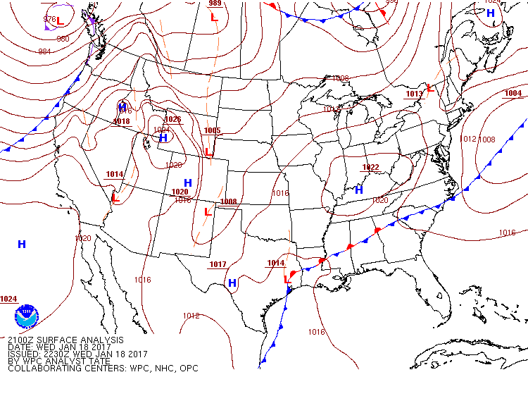
Analyzed 21Z Wed Jan 18, 2017
Valid 06Z Thu Jan 19, 2017
Valid 12Z Thu Jan 19, 2017
Valid 18Z Thu Jan 19, 2017
Valid 00Z Fri Jan 20, 2017
Valid 12Z Fri Jan 20, 2017
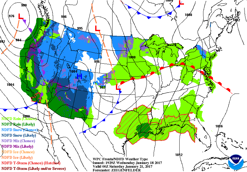
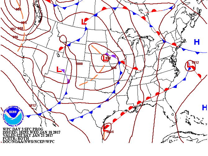
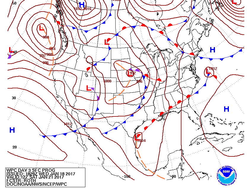
Valid 00Z Sat Jan 21, 2017
Valid 12Z Sat Jan 21, 2017
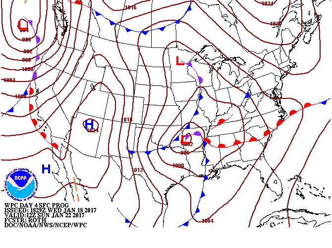
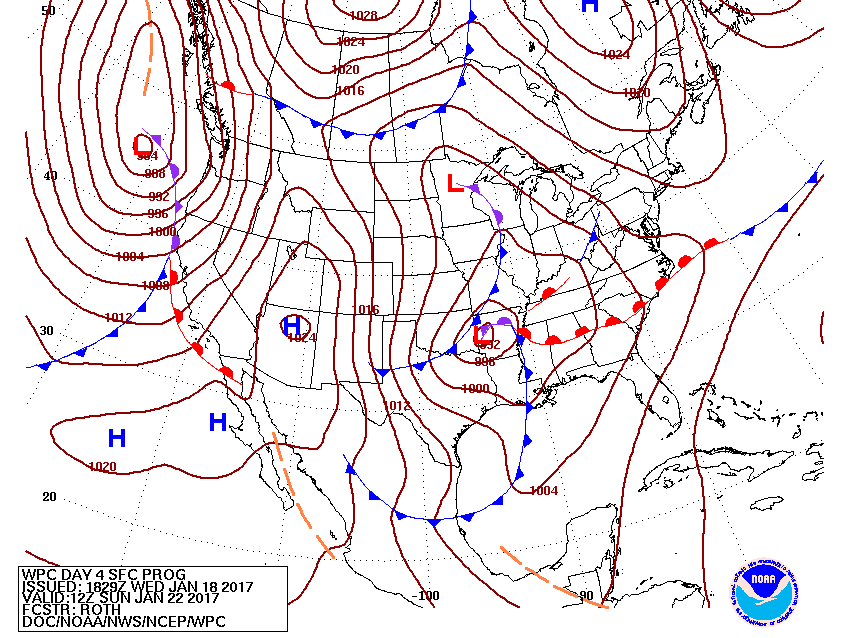
Valid 12Z Sun Jan 22, 2017
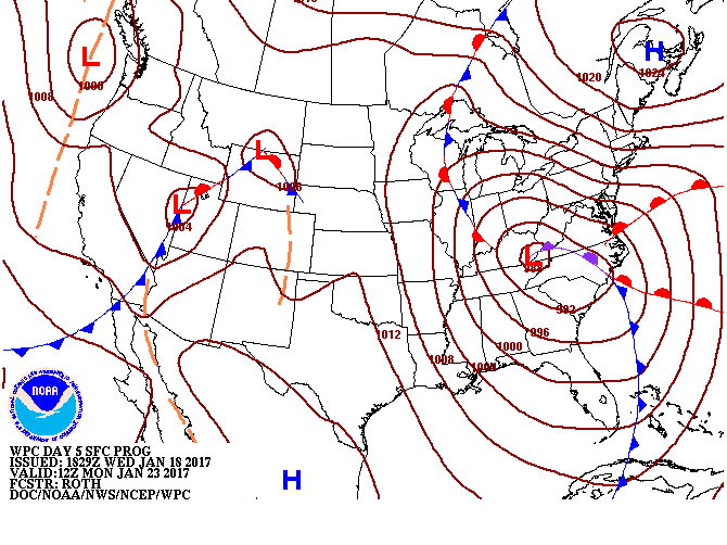
Valid 12Z Mon Jan 23, 2017
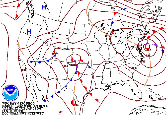
Valid 12Z Tue Jan 24, 2017
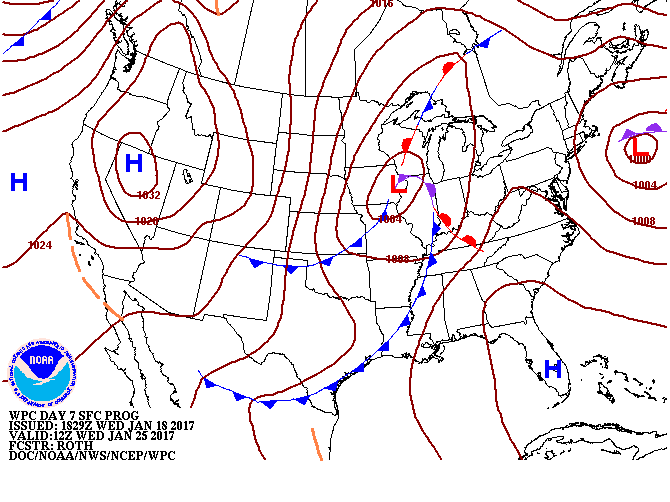
Valid 12Z Wed Jan 25, 2017

+ Short Range Forecast Discussion (Day ½-2½)
+ Medium Range Forecast Discussion (Day 3-7)
+ Additional Links
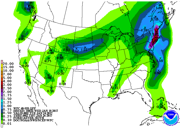
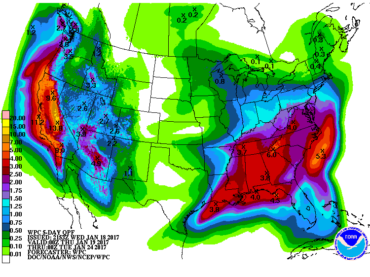
Short Range Forecast Discussion
NWS Weather Prediction Center College Park MD
318 PM EST Wed Jan 18 2017

Valid 00Z Thu Jan 19 2017 - 00Z Sat Jan 21 2017

...Heavy snow possible over the Sierras...

...Heavy rain possible over most of the West Coast...

...Heavy rain possible over the Lower Mississippi Valley into the
Tennessee Valley...

...Snow possible over parts of Northern New England...

Low pressure developing over Eastern Texas/Lower Mississippi
Valley will lift northward to the Western Ohio Valley by Friday.
The system will produce showers and thunderstorms over parts of
the Western Gulf Coast and the Lower Mississippi Valley that will
move eastward to parts of the Southeast by Thursday evening into
Friday.  During the day on Thursday, the showers and thunderstorms
will extend as far north as the Western Ohio Valley through late
Thursday night.  Rain will develop along the boundary over parts
of the Middle Mississippi Valley by Thursday morning that will
move into parts of the Upper Mississippi Valley, Great Lakes, and
Ohio Valley by Friday morning.  In addition, upper-level energy
will move over Northern New England overnight Wednesday produce
rain and higher elevation snow over parts of the Northeast through
Thursday evening.

Meanwhile, a deep upper-level trough just off the West Coast will
move inland to the Rockies by Friday.  A plume of moisture will
stream into parts of Central/Northern California that will move
southward to Southern California by Thursday afternoon.  Onshore
flow will continue to move into California Thursday into Friday.
The storm will produce rain and higher elevation snow over
California into the Pacific Northwest as well as parts of the
Great Basin and the Northern Rockies.  Rain and snow will move
into parts of the Great Basin/Southwest on Thursday moving
eastward to the Rockies overnight Thursday into Friday.  As the
upper-level trough moves inland, snow levels will drop down to
5,000 ft over the Southwestern California mountains.  Some of the
snow and rain will be heavy at times over the West Coast.


Ziegenfelder


Graphics available at www.wpc.ncep.noaa.gov/basicwx/basicwx_wbg.php
EXTENDED FORECAST DISCUSSION
NWS WEATHER PREDICTION CENTER COLLEGE PARK MD
831 AM EST WED JAN 18 2017

VALID 12Z SAT JAN 21 2017 - 12Z WED JAN 25 2017

GENERAL FLOW PATTERN/GUIDANCE EVALUATION
~~~~~~~~~~~~~~~~~~~~~~~~~~~~~~~~~~~~~~~~
A BURGEONING POSITIVE ANOMALY ACROSS EASTERN CANADA FAVORS CLOSED
CYCLONES MOVING UNDER ITS BASE NEAR THE 40TH PARALLEL, WHICH IS
SEEN WITHIN THE AVAILABLE GUIDANCE.  OVERALL, THE GUIDANCE IS
QUITE AGREEABLE AND IN BETTER THAN AVERAGE AGREEMENT.  DETAIL
ISSUES REMAIN, AS USUAL.  TO DEAL WITH THESE, STARTED WITH THE
BLEND OF THE 00Z ECMWF, 00Z UKMET, 00Z CANADIAN, AND 06Z GFS FOR
THE SURFACE PRESSURES, FRONTS, AND 500 HPA HEIGHTS EARLY ON BEFORE
INCLUDING INCREASING AMOUNTS OF THE 00Z NAEFS MEAN AND 00Z ECMWF
ENSEMBLE MEAN SOLUTIONS.  THE TEMPERATURES, RAIN CHANCES, CLOUD,
WEATHER, AND DEW POINT GRIDS WILL BE MORE ENSEMBLE MEAN-HEAVY, AS
USUAL.  THE DAYS 4-7 QPF IS EXPECTED TO BE BASED ON A COMPROMISE
OF THE 00Z ECMWF/06Z GFS EARLY ON BEFORE LEANING MORE IN THE GFS
DIRECTION LATE AS IT AND THE CANADIAN MODEL APPEAR TO BE HANDLING
THE SYSTEM MOVING FROM THE EAST OUT INTO THE WESTERNMOST ATLANTIC
BETTER THAN THE OPERATIONAL ECMWF RUN.


WEATHER THREATS
~~~~~~~~~~~~~~~

WEST/PLAINS
~~~~~~~~~~~
THE MOST PRONOUNCED EFFECTS OF PACIFIC SYSTEMS SHOULD BE IN THE
SATURDAY NIGHT-MONDAY TIME FRAME.  THE HEAVIEST RAIN/HIGH
ELEVATION SNOWS SHOULD FIRST ARRIVE AT THE CENTRAL WEST COAST
BEFORE SHIFTING SOUTHWARD WITH TIME WITH THE BEST ONSHORE FLOW.
FAVORED COASTAL LOCATIONS AND SIERRA NEVADA RANGE MAY SEE UP TO
SEVERAL INCHES OF LIQUID EQUIVALENT PRECIPITATION.  STRONGEST
WINDS WILL LIKELY AFFECT THE CNTRL-NRN WEST COAST SATURDAY
NIGHT-SUNDAY. HIGHS WILL BE BELOW NORMAL OVER MUCH OF THE WEST
DURING THE PERIOD WITH SOME AREAS MORE THAN 10F COLDER THAN AVG ON
ONE OR MORE DAYS. AS THIS SYSTEM TRACKS NORTHEAST ACROSS THE
PLAINS, THERE WILL LIKELY BE A BAND OF SNOW TO THE NW OF THE LOW
TRACK.  THE PLAINS WHICH WILL BEGIN TO SEE SOME OF THE COOLER AIR
MOVE IN FROM THE WEST BY TUESDAY-WEDNESDAY. THE FCST IS CONSISTENT
WITH THE UPPER MS VALLEY REGION SEEING MULTIPLE DAYS OF MORNING
LOWS 30-40F ABOVE NORMAL WITH SOME RECORD WARM MINS.

SOUTHEAST/EAST
~~~~~~~~~~~~~~
AS THIS SYSTEM CROSSES THE CENTRAL AND EASTERN STATES, IT WILL BE
ACCOMPANIED BY A BROAD SHIELD OF PRECIPITATION WITH THE HEAVIEST
RAINS EXPECTED FROM THE EASTERN GULF COAST NORTHEAST ALONG THE
APPALACHIANS/EAST COAST.  CONSULT SPC OUTLOOKS FOR LATEST INFO
REGARDING POTENTIAL SEVERE WEATHER ALONG THE GULF COAST DURING THE
WEEKEND.  RAIN OVER THE EAST COAST STATES WILL BE ENHANCED BY
STRONG ATLANTIC INFLOW, BUT INSTABILITY SHOULD BE MINIMAL THE
FARTHER YOU GO NORTHWARD.  A RELATIVE MAXIMUM IN PRECIPITATION IS
ALSO EXPECTED FROM THE SOUTH-CENTRAL PLAINS INTO THE LOWER OH
VALLEY WITH A SYSTEM TAPPING LESSER AMOUNTS OF MOISTURE AS THE
POLAR FRONT REMAINS FARTHER SOUTHWARD.  PRECIPITATION TYPE STILL
LOOKS TO BE NEARLY ALL RAIN WITH ANY WINTRY WEATHER (SNOW AND
FREEZING RAIN) CONFINED TO NEW ENGLAND... AND LOCALLY WITH UPPER
LOWS.  ABOVE TO MUCH ABOVE NORMAL TEMPERATURES ASIDE FROM THE FL
PENINSULA ARE EXPECTED AFTER A WARM WEEKEND.

ROTH/RAUSCH
Quantitative Precipitation Forecasts Legacy Page:


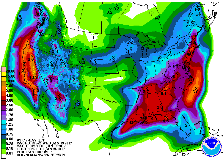
» View
Probabilistic Precipitation Guidance (Day 1-3)
+ Forecast Discussion (Day 1-3)
+ Additional Links
+ Forecast Discussion (Day 1-3)
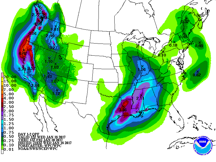
QUANTITATIVE PRECIPITATION FORECAST DISCUSSION
NWS WEATHER PREDICTION CENTER COLLEGE PARK MD
556 PM EST WED JAN 18 2017
FINAL DAY 1...DAY 2 AND DAY 3 QPF DISCUSSION
VALID JAN 19/0000 UTC THRU JAN 22/0000 UTC
REFERENCE AWIPS GRAPHICS UNDER...PRECIP ACCUM - 24HR
DAY 1...
...SE TX AND LOWER MS VALLEY INTO THE CENTRAL GULF COAST STATES/TN
VALLEY...
AN AMPLIFIED AND INCREASINGLY NEGATIVLY TILTED MID-UPPER LEVEL
TROUGH/CLOSED LOW WILL SWING THROUGH THE S-CENTRAL PLAINS TONIGHT
AND THURSDAY. HEIGHT FALLS AND FAVORABLE UPPER JET FLOW/DIFFLUENCE
WILL ENHANCE LIFT IN A MOISTURE FUELED REGION AS PER 30-40 KT LLJ
INFLOW INTO/OVER A LOWER ATMOSPHERIC AND WAVY FRONTAL ZONE. THE
REGION HAS A MID-UPPER LEVEL MOISTURE CONNECTION TO THE TROPICAL
ERN PACIFIC AND THROUGH LOWER LEVELS FROM THE GULF OF MEXICO. THIS
SUPPORTS MODEL PRECIPITATBLE WATER VALUES THAT PLUME/POOL TO AOA
1.75". WHILE ACTIVITY MAY TEND TO INCREASE TO THE NORTH WITH
SYSTEM NEG TILT LATER PERIOD...HEIGHT FALLS AND CONVECTION RELATED
GRADIENTS SHOULD TEND TO FOCUS HEAVIEST CONVECTION (UPWARDS OF
2-4"+ LOCALLY WITH TRAINING) MORE TO THE SOUTH MUCH OF THE PERIOD.
THIS WOULD LEAD TO RUNOFF ISSUES. THIS SCENARIO IS MORE IN LINE
WITH THE 12 UTC ARW/GEM REGIONAL AND RECENT UKMET/ECMWF/ECMWF
ENSEMBLE MEAN GUIDANCE. A COMPOSITE OF THESE CLUSTERED SOLUTIONS
MAINTAINS CLOSE WPC CONTINUITY. THE GFS/GEFS/NAM CONTINUE TO OFFER
A MORE NORTHWARD SHIFTED CLUSTER OF SOLUTIONS.
...PACIFIC NORTHWEST/CALIFORNIA INTO THE GREAT BASIN/NORTHERN
ROCKIES...
SATELLITE/BLENDED TPW LOOPS SHOW A LONG FETCH ATMOSPHERIC RIVER
SLAMMING INTO THE WEST COAST WITH UPSTREAM CONNECTIONS BACK
THROUGH THE WRN TROPICAL PACIFIC. THIS IS FUELING HEAVY RAIN AND
HIGH ELEVATION AND INLAND ICE AND SNOW. THIS WILL CONTINUE TO
SETTLE SOUTHEAST DURING THIS FORECAST PERIOD. PWS IN THE 700/500
MB LAYER ARE QUITE HIGH AND WILL BE AIMED NEARLY ORTHOGONAL INTO
ESPECIALLY THE SW OR/NRN CA COASTAL RANGES LATE WEDNESDAY AND THEN
DOWN INTO CENTRAL THEN SRN CA AND THE SIERRA-NEVADA INTO THURSDAY.
ENHANCED MOISTURE FLUX AND PW ANOMALIES WILL BE IN PLACE GIVEN THE
STRONG LOW TO MID LEVEL WIND FIELD AND UPSTREAM MOISTURE FEED WITH
PW VALUES OF 2 TO 3 STANDARD DEVIATIONS ABOVE THE MEAN. THE
HEAVIEST RAINS WILL BE IN PLACE ACROSS THESE AREAS WHERE SOME
LOCALLY TERRAIN ENHANCED RAINS UPWARDS TO 4" ARE POSSIBLE BEFORE
WEAKENING. THIS WILL LIKELY CAUSE CONCERNS FOR RUNOFF PROBLEMS
INCLUDING DEBRIS FLOWS AND MUDSLIDES NEAR ANY BURN SCAR AREAS.
THESE AREAS WILL BE SUSCEPTIBLE TO FLASH FLOODING IN PARTICULAR.
RUNOFF PROBLEMS HERE WILL ALSO AGAIN BE A CONCERN AND ESPECIALLY
WITH SUCH WET ANTECEDENT CONDITIONS. FARTHER INLAND...THE DEEP
FETCH OF MID LEVEL PACIFIC MOISTURE WILL CONTINUE TO OVERRUN
COLDER AIR OVER THE N-CENTRAL INTERMOUNTAIN WEST WHICH WILL
PROMOTE A LARGE AREA OF WINTRY PRECIPITATION INCLUDING SNOW BUT
ALSO LINGERING FREEZING RAIN/ICING OVER THE DEEPER INTERIOR
VALLEYS. PLEASE CONSULT THE LATEST QPFHSD FOR MORE DETAILS ON THE
EXPECTED WINTER WEATHER IMPACTS.
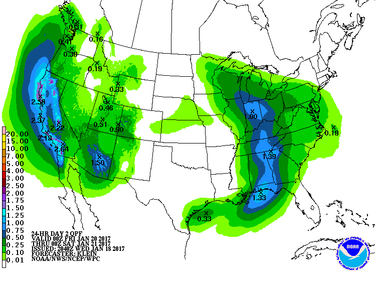
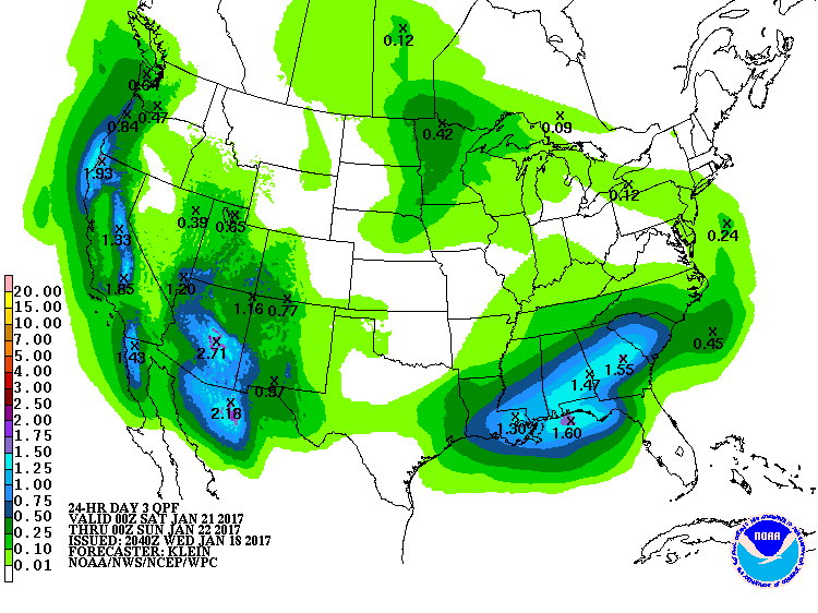
DAYS 2 AND 3...
...CALIFORNIA/PACIFIC NORTHWEST/GREAT BASIN/SOUTHWEST US...
AN ACTIVE WEATHER PATTERN CONTINUES ACROSS THE WESTERN STATES THIS
PERIOD AS AN ANOMALOUSLY STRONG PACIFIC JET SENDS A SERIES OF
ENERGETIC SYSTEMS THROUGH THE REGION. MODEL MASS FIELDS WERE IN
RELATIVELY GOOD AGREEMENT...SO GENERALLY FAVORED A MULTI-MODEL
BLEND FOR THE DAY 2/3 QPF.
AT THE START OF DAY 2...00Z FRIDAY...ONE SHORT WAVE TROUGH WILL BE
MOVING QUICKLY THROUGH THE SOUTHWEST AND SOUTHERN INTERMOUNTAIN
REGION BEFORE EXITING INTO THE SOUTHERN HIGH PLAINS DURING THE DAY
FRIDAY. STRONGEST DYNAMICS WILL FOCUS EARLY IN THE PERIOD ACROSS
AZ AND TO A LESSER AMOUNT FARTHER NORTH INTO SOUTHERN UT AND THE 4
CORNERS REGION. PWATS REMAIN ANOMALOUSLY HIGH (1-2 STANDARD
DEVIATIONS ABOVE NORMAL)...BUT OVERALL WILL BE DECREASING WITH THE
SYSTEM BECOMING CUT OFF FROM ITS PACIFIC MOISTURE SOURCE.
REGARDLESS...WITH UPSLOPE FLOW ENHANCING LIFT ALONG FAVORED WEST
TO SOUTHWEST-FACING SLOPES..EXPECT MODERATE TO LOCALLY HEAVY
PRECIPITATION (SNOW AT HIGHER ELEVATIONS) ACROSS CENTRAL/SOUTHERN
AZ. AREAL AVERAGE AMOUNTS WILL GENERALLY RANGE UPWARDS OF 1-1.5
INCHES...HEAVIEST ALONG THE MOGOLLON RIM.
UPSTREAM...THE NEXT IN THE SERIES OF SYSTEMS WILL REACH THE CA
COAST BY 12Z FRIDAY...THEN ADVANCE QUICKLY THROUGH THE
SOUTHWEST/SOUTHERN INTERMOUNTAIN REGION FRIDAY
NIGHT/SATURDAY...EVENTUALLY EMERGING INTO THE SOUTHERN HI PLAINS
BY THE END OF DAY 3. IMPRESSIVE UPPER DYNAMICS WILL SUPPORT TRIPLE
POINT LOW DEVELOPMENT JUST OFF THE CA COAST FRIDAY MORNING...WHICH
COMBINED WITH STRONG ONSHORE FLOW WILL BRING MODERATE TO HEAVY
PRECIPITATION INTO NORTHERN/CENTRAL CA BY FRIDAY MORNING. WITH
THE COLD FRONT PUSHING INLAND DURING FRIDAY...PRECIPITATION WILL
ADVANCE DOWN THE COAST AND INTO THE SOUTHWEST BY LATE IN THE DAY.
MODELS INDICATE THAT THIS SYSTEM WILL TAP INTO DEEPER MOISTURE
THAN ITS PREDECESSOR...SO WHILE IT IS A FAST-MOVER...SUSPECT THE
DEEP MOISTURE AND STRONG DYNAMICS WILL LEAD TO HIGH PRECIPITATION
RATES...ESPECIALLY ALONG COASTAL RANGES AND INTO THE SIERRAS.
AREAL AVERAGE AMOUNTS IN THESE AREAS WILL RANGE FROM 1-3 INCHES.
MAIN CONCERN FOR FLASH FLOOD POTENTIAL WILL BE ACROSS THE SOUTHERN
CA BURN AREAS...SO AM MAINTAINING A MARGINAL RISK FOR EXCESSIVE
RAINFALL THROUGH THE DAY 2 AND EARLY DAY 3 PERIODS.
DURING DAY 3...THE HEAVIEST QPF WITH THIS FEATURE WILL BE MOVING
THROUGH THE SOUTHWEST AND SOUTHERN INTERMOUNTAIN REGION. MODELS
ARE TRACKING THIS FEATURE FARTHER SOUTH THAN THE WAVE THAT MOVES
THROUGH ON DAY 2...AND ALSO MAINTAINING A BETTER CONNECTION TO ITS
PACIFIC MOISTURE SOURCE (POSSIBLY A RESULT OF LESS SHORT WAVE
RIDGING DEVELOPING IMMEDIATELY UPSTREAM). AS A RESULT...BELIEVE
QPF WILL BE BOTH HEAVIER AND POSSIBLY CENTERED A LITTLE FARTHER
SOUTH THAN ON DAY 2. AREAL AVERAGE AMOUNTS ACROSS MUCH OF
SOUTHERN/CENTRAL AND NORTHWESTERN AZ WILL RANGE UPWARDS OF .50-1
INCH...WITH LOCALLY HEAVIER AMOUNTS ALONG FAVORED SLOPES ALONG THE
MOGOLLON RIM. MEANWHILE...PERSISTENT POST-FRONTAL ONSHORE FLOW
AROUND THE CYCLONE OFF THE PAC NW COAST WILL MAINTAIN UNSETTLED
SHOWERY WEATHER ACROSS NORTHERN/CENTRAL CA NORTHWARD THROUGH
WESTERN SECTIONS OF OR/WA.
...MS VALLEY INTO THE TN/OH VALLEY/GREAT LAKES/SOUTHEAST/GULF
COAST STATES AND MID ATLANTIC...
DAY 2...THE UPPER LOW OVER THE CENTRAL PLAINS AT THE START OF THE
PERIOD WILL OPEN UP AND TAKE ON AN INCREASING NEGATIVE TILT AS IT
LIFTS THROUGH UPPER MIDWEST AND GREAT LAKES STATES. HIGHLY
DIFFLUENT FLOW ALOFT OUT AHEAD OF THE LOW AND ITS TRAILING SHORT
WAVE ENERGY COMBINED WITH A FEED OF GULF MOISTURE WILL SUPPORT
WIDESPREAD SHOWER/THUNDERSTORM ACTIVITY FROM THE EASTERN GULF
COAST NORTHWARD THROUGH THE TN INTO OH VALLEYS ON THURSDAY NIGHT.
MODELS WERE IN GENERAL AGREEMENT WITH THE EVOLUTION OF THE MASS
FIELDS...SO AGAIN OPTED FOR A MULTI-MODEL BLEND INCORPORATING THE
GFS/ECMWF/CANADIAN GEM AND NATIONAL BLEND. WHILE THE CONVECTION IS
EXPECTED TO REMAIN PROGRESSIVE...GIVEN THE ANOMALOUS PWATS OF 2-3
STANDARD DEVIATIONS ABOVE NORMAL AND SOME POTENTIAL FOR LOCAL CELL
TRAINING...WILL MAINTAIN A MARGINAL RISK FOR EXCESSIVE RAINFALL
FROM THE CENTRAL GULF COAST STATES INTO THE TN VALLEY THROUGH THE
EARLY PART OF DAY 2.
DURING FRIDAY MORNING...ENERGY ALONG THE SOUTHERN END OF THE
TROUGH WILL WEAKEN AS IT MOVES THROUGH THE MEAN RIDGE POSITION AND
PUSHES OFF THE EAST COAST...TAKING WITH IT THE MAIN FEED OF GULF
MOISTURE. AT THE SAME TIME...THE SHORT WAVE ENERGY FARTHER NORTH
BECOMES MORE STRUNG OUT AND IMPINGES UPON A MORE STABLE AIR
MASS...THUS OVERALL QPF WITH THIS FEATURE WILL BE LESSENING DURING
THE DAY ON FRIDAY. EXPECT AN AREA OF .10-.40 INCH QPF FROM THE
UPPER MIDWEST SOUTHEASTWARD THROUGH THE LOWER GREAT LAKES AND
MID-ATLANTIC REGION BETWEEN 12Z FRI-00Z SAT (SO SOME RAIN FOR THE
INAUGURATION IN DC ON FRIDAY...BUT AT THIS TIME...FORECAST AMOUNTS
ARE EXPECTED TO REMAIN LOW ENOUGH TO PRECLUDE FLASH FLOODING
CONCERNS).
DURING DAY 3...THE UPPER TROUGH MOVING THROUGH THE SOUTHWEST ON
DAY 2 WILL PUSH INTO THE PLAINS...LOWERING HEIGHTS ACROSS THE
SOUTHERN PLAINS AND WESTERN GULF COAST STATES. THIS WILL ALLOW
GULF MOISTURE TO ONCE AGAIN FLOW NORTHWARD AND OVERRUN THE
REMNANTS OF A WEAK BOUNDARY ASSOCIATED WITH THE ABOVEMENTIONED
FEATURE MOVING INTO THE UPPER MIDWEST DURING DAY 2. MODELS
INDICATE POTENTIAL DEVELOPMENT OF A SOUTHERN STREAM JET
COUPLET...AND COMBINED WITH HIGH PWS AND A VERY UNSTABLE AIR MASS
IN THE VICINITY OF THE SURFACE BOUNDARY SHOULD SUPPORT CONVECTION
BREAKING OUT FRIDAY NIGHT ALONG THE CENTRAL GULF COAST AND EXPAND
EAST-NORTHEASTWARD ACROSS THE SOUTHEASTERN U.S SATURDAY. THERE ARE
SOME DIFFERENCES HANDLING THE SPEED AND NORTHWARD EXTENT OF THIS
CONVECTION...WITH THE NAM NOTABLY FARTHER NORTH THAN THE CONSENSUS
OF OTHER GUIDANCE. AT THIS POINT...AM FAVORING A BLEND OF THE
GFS/ECMWF AND IN-HOUSE ENSEMBLE BIAS-CORRECTED GUIDANCE...WHICH
SUPPORT AREAL AVERAGE AMOUNTS OF 1-2 INCHES FROM CENTRAL LA
EAST-NORTHEASTWARD THROUGH SOUTHERN MS/AL AND CENTRAL GA. BY THE
END OF THE PERIOD...LEFT EXIT REGION JET DYNAMICS FROM THE SYSTEM
THAT AFFECTS CA AND THE WEST COAST DAY 2 WILL LIKELY SUPPORT
ADDITIONAL CONVECTION DEVELOPING ALONG THE CENTRAL EASTERN GULF
COAST BY SATURDAY AFTERNOON/EVENING.
GRAPHICS AVAILABLE ON THE WEB AT
WWW.WPC.NCEP.NOAA.GOV/QPF/QPF2.SHTML
SCHICHTEL/KLEIN
24HR QP VT 20/00Z
0.01 469621 476627 482636 484642 488647 494650 500657 503663
505670 505694 507710 505725 504730 501736 497743 487763
479784 475793 472798 467800 463797 461793 461789 464784
469775 471769 472761 469755 467751 463749 457749 446752
442755 439762 436763 434760 431754 433749 434744 434738
434734 431733 430731 429729 427731 423733 422730 426722
425717 422712 422708 425703 428700 429694 430689 431685
429683 429672 429666 431658 433649 436644 439641 441637
443634 449628
0.01 535201 536194 536189 530181 524171 520168 517164 513162
510159 503152 492139 489136 485134 480133 478132 472138
481144 482147 481149 477150 472148 470145 467140 464138
464129 463125 464118 464117 461112 452110 450111 447111
440110 432106 421105 413107 411107 409105 408100 406092
404086 402083 399087 394083 388085 381080 375079 370081
365086 360086 356084 343101 340095 335095 333098 331103
331111 330118 328124 324131 322136 322142 321146 319149
315151 303150 301154 299160 297166 299167 305173 307175
309179 314185 320192 326200 328211 339225 345231 350237
371244 389255 399260 409264 419266 423268 427267 447273
458277 464279 466278 469279 488286 498290 508293 511284
516275 519270 519264 520255 519247 517235 516228 514224
513218 513215 515214 519215 522214 528215 531211 535201
0.01 434909 434898 432890 423874 419867 415863 411857 405852
393846 386844 378840 365838 362839 357840 351842 350837
348835 345841 341844 336845 326846 307847 300849 294853
284862 275875 267886 264893 261899 255911 246925 244932
244943 244953 243960 241968 242979 246984 249986 248988
246991 242997 240007 239014 239018 241020 243022 247023
254020 257017 260015 264013 266010 271005 277001 286991
290987 294981 298974 304968 315960 321957 328959 336958
340957 344956 356947 367938 369936 373934 379940 384943
388943 391941 400939 407941 415941 422938 428933 431926
434909
0.01 409789 407787 405787 403789 400790 398791 395793 393794
391796 392799 395798 397796 400795 404795 405794 407792
409789
0.25 516259 516252 515244 510230 503215 499210 491207 486202
482203 472210 466211 461211 452215 442217 436221 431222
427223 423223 421219 421215 420211 418208 413204 412201
408199 402201 396198 388194 380187 375183 370180 366177
364171 362164 366163 370163 371160 373162 380165 387167
392168 396170 402174 408176 413181 415183 418181 422178
424176 428176 433180 437184 442186 447185 458182 470173
474175 476178 477182 479190 481193 484196 487196 489194
494190 503184 508183 514185 518189 522192 522188 518182
513177 508173 501169 496163 491159 485157 480158 475158
472156 467153 463153 462158 461163 460166 459165 455161
452155 443145 437128 433124 426127 417133 407126 401123
397124 396127 396132 395136 393140 389140 382138 379137
378133 375127 372120 366118 355127 349117 344113 340113
339116 340121 338131 339136 340139 343144 347155 350157
349161 345160 330158 313158 310160 310164 313169 322178
326182 329188 331193 331199 332205 334212 337217 343222
369237 380242 394247 402250 410252 422253 432253 445251
458251 467253 475256 483265 491276 496281 502284 507282
510278 512274 514267 516259
0.25 486236 487233 487231 485233 486235 486236 486236
0.25 480680 480675 477675 475674 472673 470673 468674 466677
466681 465684 465687 467689 470687 472688 474687 477684
478683 480680
0.25 400901 401894 399887 394876 389869 382862 375857 370856
364855 352855 342858 332862 321866 310869 303872 295877
287885 277900 273907 268917 264927 262937 259947 254958
252962 254968 259970 261972 267980 271981 277979 283974
290966 296960 304954 312949 319945 337935 344931 350930
354927 363923 366921 369915 379916 384916 387913 391908
395906 400901
0.25 359163 358162 356161 355162 356164 358164 359163
0.50 513263 514259 515253 513245 510235 507228 500216 497213
493213 486211 481211 474214 472216 468216 464214 460215
449221 444223 444226 447227 453227 457228 458231 443231
439234 435234 430233 424233 419228 417223 417218 416214
413211 410211 405207 400203 393199 383192 372184 358177
352180 349178 347175 345169 341164 336162 331162 327160
322160 320160 316163 315166 317168 323173 327177 330181
333186 335195 335204 338211 342216 347221 359228 371234
386242 401247 414249 428250 441248 455246 465246 472247
480249 488265 495276 498278 502279 505277 507274 513263
0.50 503254 502248 500244 494237 490228 488223 485220 479219
474219 472221 469225 475227 478231 481235 483245 490244
496251 498255 501256 503254
0.50 452173 452166 451161 446154 440147 437138 434135 429133
425136 423140 422145 424150 426159 429163 433166 439172
442174 446174 452173
0.50 407159 407156 407154 406152 404151 403151 401153 400155
401157 402158 403160 405160 407159
0.50 375143 374139 370136 365137 363141 360141 356138 351139
352144 357145 361145 363144 366145 369147 373147 375143
0.50 380895 380890 380884 379878 377874 371869 365867 351861
345862 338867 332870 323873 309878 301880 294885 288890
284895 275908 272914 270921 269931 267941 266950 267958
272963 275965 281965 286962 292957 305949 317941 341924
353915 364907 374902 378898 380895
1.00 502236 502233 502232 501230 500228 500227 500224 499224
498221 496221 495221 493222 493225 493228 494229 494230
495233 496235 498236 499236 501237 502236
1.00 445240 444239 443240 444240 445240 445240
1.00 446162 445160 443157 441154 440152 438151 436148 434145
432144 430147 430152 431154 432157 435160 437161 439163
442165 445164 446162
1.00 430243 428240 424237 415233 413229 414224 413218 412216
408215 405212 399206 385196 372185 363182 357182 356187
362192 365195 367200 370208 368210 363208 355204 352201
349197 345179 343170 340167 337168 340172 340174 338174
335169 335167 330164 325165 326168 332174 337181 339189
340200 341204 344208 351213 356218 358221 362224 379232
395241 404244 413244 424246 428245 430243
1.00 366889 364883 360877 352870 344870 338873 329879 305889
293894 288897 284902 277912 275916 274925 275933 274943
277950 283951 288952 294949 303943 323930 333922 342915
351906 359899 363894 366889
1.50 442159 441156 439155 438154 436153 435155 436156 437158
439159 440161 442159
1.50 411223 411221 410220 408220 407222 407224 407225 408227
410225 411225 411223
1.50 404217 402211 399208 390202 382195 375188 370185 364184
360185 362189 369196 376205 379208 384211 394216 398219
403218 404217
1.50 372222 373220 372218 370218 369219 369222 371223 372222
1.50 365220 366219 365216 363214 362213 360212 358211 357212
357214 358215 358217 359218 360219 361220 362221 364221
365220
1.50 346198 346196 346195 346196 346198 346198
1.50 355894 356887 354879 350875 346874 337879 329884 320889
311893 300897 291901 288903 284908 280916 279923 279929
280935 280941 283944 289946 297942 314931 330919 337913
343906 355894
2.00 400216 400211 397208 392204 385200 379194 374189 368186
364186 364189 370194 375200 381204 386208 393212 399216
400216
2.00 350892 350886 349882 347879 344880 329888 322893 314896
297903 289906 286910 284914 284918 284925 285935 286940
292940 299937 307932 314926 326916 339905 345899 350892
24HR QP VT 21/00Z
0.01 521261 519252 517243 511229 505217 502211 498207 491205
489203 491201 491196 490196 483198 473200 460199 454202
449197 449193 451190 455186 459182 461178 462173 464169
468170 470169 475172 480173 481178 483185 488188 491190
493194 498195 503195 507193 514193 514187 516185 521181
523179 522176 519172 516166 512160 509156 504157 499161
493162 488162 484156 477154 472152 470148 468144 467139
467133 467130 467124 469116 475104 479099 480097 481092
482082 482075 481072 476069 473068 471066 468060 463061
459067 454068 418083 415074 415065 411059 407055 402053
397054 389062 381059 379062 374060 372057 374055 373052
369052 362051 356052 351055 345056 329053 325054 323056
318060 313062 311064 311069 310073 308075 304078 299084
295089 291096 289103 286114 289127 291140 292143 291146
288155 284167 283172 285174 287179 290186 292189 291193
292207 298218 306226 323244 328256 331261 334264 339270
346275 362279 370282 377285 388290 402295 414304 419308
425311 430314 437317 445318 449319 452319 458320 465319
474318 480316 481306 483302 485300 489295 498292 503289
505289 506284 506279 508277 512272 518266 521261
0.01 499152 498149 495147 491140 489136 486135 479132 473126
472133 470137 472141 480140 486145 489149 491150 493153
496153 499152
0.01 491942 491930 489922 486909 483894 480884 479878 477873
472860 467851 463841 456828 451818 442796 437784 432773
423753 420747 416743 409735 396724 374723 363722 360722
356725 345733 337740 330745 324754 321758 321763 321770
322773 324778 323784 324791 324795 321797 317798 316800
311804 308808 304812 292824 278839 274842 270846 267853
262866 259876 255885 255889 257893 254903 253909 253916
253921 255927 259936 261938 265938 268941 266943 262954
260958 261964 262969 263972 265973 265979 265982 267983
273983 277980 281982 287981 292979 295975 298969 300963
302957 301949 300944 300937 301926 304913 306907 307905
310903 322903 333903 341902 348901 354900 360899 372899
382901 389908 395917 409929 414933 419936 428940 447945
454952 462957 466960 473960 478959 482957 485953 487948
491942
0.01 443171 441168 440163 437158 434155 434150 437146 434141
431140 429142 424150 420150 417147 414144 409145 409149
412150 415153 419161 426167 432173 437174 441173 443171
0.01 433983 433973 430970 423961 419956 417952 411942 408937
405933 401931 396931 393936 393944 393959 394964 393966
391974 389979 387986 383997 383001 381004 381010 380020
380028 382033 385038 389041 392039 397027 401015 404008
406005 410998 413996 418992 422990 426988 429987 433983
0.01 340069 340067 339065 337065 335065 333065 331066 330066
328066 327068 328070 328072 329074 331074 333074 334074
336073 338071 340069
0.25 498229 498226 497226 496226 495228 495229 497230 498229
0.25 483270 484266 484262 481257 475249 474244 475239 477235
477231 474233 473236 471240 466239 463236 461231 457228
452230 442230 438231 434233 429233 426231 427228 434226
437222 437218 435217 429215 425215 422217 421214 419210
415207 411207 407202 398197 390193 384191 378185 372177
366171 365168 365162 368156 371152 374148 375143 377137
376132 376126 374122 366118 358118 351113 346104 345098
347093 344088 341087 332082 323084 316088 310095 306102
305108 305113 308119 311122 316125 321126 326127 329130
335135 343141 347144 351146 353149 353155 353158 351161
346165 342163 338160 335160 316155 309154 305156 305161
309169 311173 312179 318199 321203 323206 328212 333220
338227 346243 353252 360258 374269 383274 393279 409288
421293 427295 432296 440295 448293 454291 462288 467289
472287 478284 483270
0.25 462913 463905 463899 461890 455877 454867 451860 444848
441837 440834 436835 434835 432833 429827 424811 421804
418797 414790 409785 405782 399780 396786 395794 392796
392800 393808 389810 384810 377810 371808 364808 356809
349812 339819 336821 331822 325826 311829 304831 299834
294839 290843 282856 277867 272881 270888 270896 273904
275907 278908 291906 296903 300899 308888 320880 327882
331885 346883 358886 363885 366884 373881 377880 381880
386881 392884 398888 408896 413901 419905 431909 443913
448917 453919 458918 460916 462913
0.25 427235 427233 426230 424232 425234 426235 427235 427235
0.25 399120 400118 399116 397115 396115 394113 392114 392116
392117 394118 395119 395120 397120 399120 399120
0.25 396089 398081 397076 393072 387071 382074 380073 373065
369063 365065 364070 365073 366079 367085 369090 375098
376101 378101 380097 387098 390095 392096 396089
0.25 367137 367136 365136 363137 361137 360138 360141 361142
362143 364142 364141 365139 366138 367137
0.25 287952 288945 286941 284939 281941 280945 278949 278956
277960 276966 277968 279968 282966 284962 285959 286956
287952
0.50 463279 462276 461275 460277 460278 462279 463279
0.50 457269 459264 459260 457254 453247 447244 442243 433242
424236 417230 416226 416218 415215 413214 408213 400205
394200 385195 378189 373184 369182 361178 351177 346171
343166 337164 328161 322159 316158 312159 311162 312165
323180 331197 340214 345222 350228 358237 363243 368251
374258 379262 384264 393268 402274 410279 421284 429285
437282 444277 448275 451272 457269
0.50 434885 435880 434875 432870 428861 423852 419842 415836
412833 405829 400826 396824 387829 377833 373836 368836
362828 354825 347826 344829 337836 327839 315840 309839
304840 298845 291853 287860 282870 280880 278890 279896
282899 288897 292894 298889 305882 313877 322872 330870
335871 339874 343875 348875 362875 367874 371871 380866
385866 389868 404880 420889 425891 428890 434885
0.50 365202 364199 362197 361195 359192 356189 355187 353185
350186 349190 350193 352195 355198 357199 360201 362202
365202
0.50 352122 351117 347113 343103 342097 339093 336090 330090
322094 319095 318098 316103 316111 320114 329118 334121
337124 340128 345131 347128 348123 352122
1.00 428252 428244 425239 417234 413230 414222 412218 408218
406217 403214 401210 397206 393204 388202 383200 379196
376192 372188 368185 363182 358184 360188 364191 371198
381204 386207 389211 393215 397218 401221 402224 397227
391225 384221 364211 354204 351200 349196 346185 344174
342168 336166 326162 320161 319166 326172 346208 352211
354216 357219 363222 374237 379242 384244 393249 403254
414258 419257 423256 428252
1.00 348849 348846 348844 347842 347840 346838 344839 343840
343841 341843 341844 341845 341846 342847 343849 345850
347850 348849
1.00 313864 313861 311860 304860 299861 294866 292870 289877
290881 292883 296881 301878 305875 309871 313867 313864
1.50 411228 412226 412224 411221 409221 407222 406224 407226
407227 408228 410229 411228
1.50 401246 402240 400235 397233 393234 390231 387228 382227
380231 382236 385238 390241 394242 398245 401246
1.50 400213 398211 397210 395209 394209 394212 396214 398214
400213 400213
1.50 369190 368187 367187 366186 364185 362185 361186 362187
363188 364189 365189 367190 369190 369190
1.50 346200 346198 346197 345196 345194 344195 344198 345200
345201 346200
1.50 344189 344186 343184 343182 343181 341180 341181 340183
340186 341188 342189 343189 344189
1.50 332166 330166 329165 327165 328167 330167 332167 332166
24HR QP VT 22/00Z
0.01 569972 567967 567960 564952 563948 561944 558941 555938
552932 549925 544920 537920 524896 520894 516895 514897
512895 511892 508882 508877 506872 504865 500855 497847
494840 491833 488825 480809 476801 472795 467788 462782
461786 462792 463800 469818 475835 476844 472839 463828
453816 440788 436778 434775 433769 426750 420733 416727
412724 406719 400716 395712 391710 387712 383710 379711
370713 366714 363717 354719 341724 337731 332730 330732
323736 319742 315747 311752 308758 305765 300772 301781
301786 300791 301801 300806 298809 293813 289819 284823
273834 268838 266841 266846 263853 263860 263870 262879
261882 261888 263897 266934 266944 267953 268959 270963
272966 275968 281968 289965 294968 297971 297975 299982
300987 300992 296012 294018 290024 288027 287033 285041
285046 286049 285059 277062 270064 267066 267070 269077
271080 270084 268091 269096 272100 275106 278112 281118
283122 283126 281134 279144 279149 280151 284159 288167
291172 294178 301191 306196 311199 317205 323209 328214
335220 346230 352236 358242 356244 355248 356257 358264
359267 362270 367275 376277 392282 409287 418290 423292
427291 435293 440291 443289 448289 451292 456295 457298
457304 460311 461314 465315 472318 484323 496328 516280
512276 511268 511249 509243 509238 508235 507227 505221
502217 498216 496213 495207 497203 496195 492191 480188
472195 463198 458201 454200 453198 451196 451193 451185
0.01 451185 451176 454176 456172 455167 456159 454152 448141
457141 457138 453133 446128 443122 445118 446117 450114
451111 451107 447098 443096 438098 434097 430092 426091
428094 429101 427106 423105 420104 417102 412093 410088
412082 414076 414069 412065 407061 397055 392054 387051
383049 378044 375040 375033 376021 378016 379012 378004
376999 376994 373990 367990 362988 353989 347989 344989
344992 342998 342004 345008 347013 344016 340019 336021
332021 327020 323020 320018 318013 317010 317005 317001
315997 315994 319983 323972 328960 334950 341943 357930
362927 365924 368920 373916 379907 385902 395884 397881
398882 400885 402890 406903 410916 410931 409933 409937
408946 407952 407961 405963 405967 404975 405991 408003
411007 413013 416017 422018 430011 436004 441993 447993
452996 461999 468009 471013 473019 481027 484027 486027
487030 487036 486043 487050 490055 496066 495074 493078
497092 500095 503103 506107 510113 517119 523126 534128
547126 553124 556122
0.01 493079 490073 484067 475059 465050 460047 453046 445045
443045 441048 440053 439057 438067 442071 448073 450075
454076 460077 463075 465071 469071 472072 483078 489081
493079
0.01 447736 447734 447732 446731 445731 443732 443735 445737
445738 447737 447736
0.01 437211 434198 431193 426189 425186 425182 421178 416173
411170 404168 402172 402176 403189 401190 398190 397194
399195 402196 405196 410194 413193 420197 423198 425200
428204 432209 437211
0.01 441834 432824 431820 429817 425813 421808 417802 410791
407784 403778 400772 396768 391763 389761 384761 381761
377760 370762 367764 369766 371770 372774 377789 378799
380807 381812 382816 385822 394832 398837 402843 405848
410854 407868 413872 416872 419874 422871 424867 426862
430861 429857 427850 427845 428841 431835 435834 439835
441834
0.25 506967 506959 504952 502938 501931 498926 493916 490912
488911 485912 481921 477924 472926 468928 464931 456937
450945 443954 441958 437961 435965 435968 436969 445965
454961 458962 462964 471969 476972 479971 482971 483973
485978 490981 495982 499980 502976 506967
0.25 476289 476287 476286 475285 474285 475286 475288 476289
476289
0.25 480262 483248 481243 480237 478232 476231 474232 472239
468238 465236 463231 462225 464218 465214 460211 453216
446218 437219 427219 423217 421214 417210 415210 409210
405207 396201 390196 382191 374185 370182 366180 356178
352178 349181 344190 338197 338202 340206 346211 354217
360224 368230 380243 387250 395256 403261 412266 423268
432269 450269 459267 467268 476268 480262
0.25 469281 469278 469277 468276 468274 466273 465272 463274
464276 464277 465279 466280 467281 468282 469281
0.25 417123 417119 416117 410117 405117 402113 399109 395108
384110 383106 386102 390099 390090 389084 385079 381076
378071 373063 369060 362060 351062 347065 349070 347077
343078 340079 338078 336072 338068 341065 342060 341056
338053 327050 321049 316047 309045 305045 303047 301054
301061 302069 297070 285071 280072 277073 276078 277084
278090 282099 286109 291119 297126 305133 311134 318134
324132 327134 330138 331144 336147 340148 351150 358151
363154 368154 373152 381147 383141 384133 387129 392125
399120 404119 408122 414125 417123
0.25 399225 399222 397220 394218 390215 385213 377209 371203
362197 359196 355196 355200 359203 366209 373214 379220
382223 387226 390227 394227 399225
0.25 359819 360810 358803 353793 341773 341764 342759 342752
342748 339747 335746 329748 324752 320756 316765 316772
318778 320784 320791 318802 314813 309824 305827 300827
295828 291831 284839 280849 275861 273871 272879 273886
276900 277907 279914 281926 285935 290945 295949 301951
308951 310950 317951 321949 328940 332935 328933 326928
325926 326922 335900 342877 346866 350855 357832 359819
0.25 354111 353109 353108 352107 351108 351109 352110 353111
354111
0.25 343177 344171 343167 341165 336161 333157 328153 323154
317152 312148 307145 300144 297144 294146 292153 295158
298162 308170 318176 328181 333182 340181 343177
0.50 459240 457236 455236 450235 446236 444240 440241 434236
427232 420227 417227 415224 414220 412217 388198 375189
368183 361181 354180 351183 351188 367194 378205 391214
397218 402220 404223 403226 399229 393230 389230 385229
382231 382236 388242 394247 401251 408254 417256 425256
431256 439254 442252 444250 444245 447244 454243 459240
0.50 377139 379123 366124 363121 362122 361128 358127 354119
351114 348108 345099 343091 339085 334080 327077 325076
321078 316080 307079 300076 292075 285076 281080 282088
287102 291108 295113 299120 304124 311128 318129 328121
333127 336133 341139 346143 350143 352142 357137 361138
363142 367148 369149 373146 377139
0.50 378098 379096 380094 379092 378091 376091 374093 373096
373098 374099 375100 376100 377099 378098
0.50 351822 351811 347803 342796 337792 332792 330794 326802
322808 319816 314831 312835 308836 302834 297833 295835
290841 287849 286856 284864 281873 280878 280884 282892
285911 287920 290928 294934 296937 299939 302939 305936
310930 317918 322911 325904 327896 331889 336874 342857
346840 349830 351822
0.50 338170 337167 334165 327160 320157 314153 307149 302149
299152 300156 302159 309164 314167 321171 325172 328172
335171 338170
0.50 332060 333058 332056 330055 329055 327054 325055 324057
324059 325061 326062 327061 328061 330061 332060 332060
1.00 427247 427244 425242 421238 416234 411233 405235 400236
399239 400241 404245 407248 410249 417249 423250 427247
1.00 390208 391206 390205 390204 389203 387202 385201 385200
384200 382199 380198 379197 377196 376198 377199 378201
380202 381203 383204 385205 386207 388208 389208 390208
390208
1.00 367189 367187 366186 364185 362184 361184 359184 357184
355184 356187 357187 358188 360188 362189 364189 365190
367190 367189
1.00 347116 347113 346110 343105 341100 338094 337092 333092
329095 325098 322100 321104 324109 329113 333116 338120
341121 343120 347116
1.00 340825 340818 338811 333808 330811 324819 320830 316842
314847 309850 304847 300844 297844 295846 294851 292865
290878 290892 292898 294903 297908 300913 302914 305914
308911 311906 313901 315894 317890 321879 326868 334847
340825
1.00 328168 329166 328166 327164 326163 325163 323162 322161
320161 318160 317159 316159 315161 316163 317164 318164
319165 321166 321167 323167 325168 326168 328168 328168
1.00 317116 317110 315106 314103 313096 314090 312087 306086
303083 299082 294081 290083 289087 292096 297103 303108
307115 310118 315118 317116
1.50 418242 419240 417239 416238 414238 414239 412240 413242
415243 417243 418242
1.50 343114 343111 342111 341109 339107 338106 337106 335106
334105 333106 333108 334110 335112 336114 338114 339115
340115 342114 343114
1.50 329826 329824 327826 326827 326829 328830 329829 329827
329826
1.50 304093 305091 305089 304088 303087 302086 301085 299085
297084 296086 295087 295088 296090 297091 298092 298093
300094 302094 304093 304093
1.50 303871 303870 303869 301868 299868 298868 297866 297868
297870 297872 297874 297875 298876 299877 301876 301875
302874 303873 303871
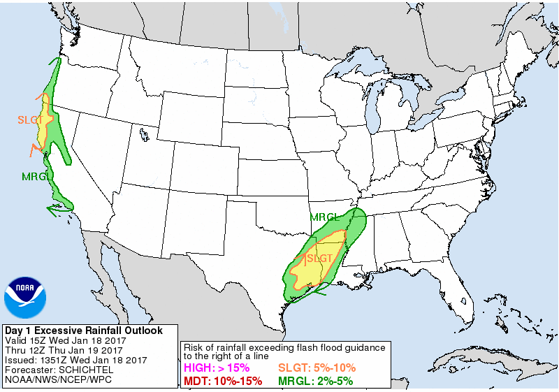
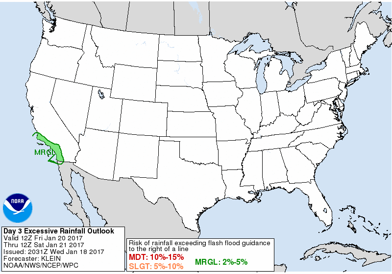
Excessive Rainfall Forecasts Legacy Page:
Valid 15Z Wed Jan 18 2017 - 12Z Thu Jan 19 2017
Valid 12Z Thu Jan 19 2017 - 12Z Fri Jan 20 2017
Valid 12Z Fri Jan 20 2017 - 12Z Sat Jan 21 2017

+ Forecast Discussion
+ Additional Links
EXCESSIVE RAINFALL DISCUSSION
NWS WEATHER PREDICTION CENTER COLLEGE PARK MD
851 AM EST WED JAN 18 2017

...VALID 15Z WED JAN 18 2017 - 12Z THU JAN 19 2017...
...REFERENCE AWIPS GRAPHIC UNDER...DAY 1 EXCESSIVE RAINFALL...


MARGINAL RISK OF RAINFALL EXCEEDING FFG TO THE RIGHT OF A LINE FROM
50 NW ONP 30 NW S47 25 SSE AST 25 WSW MMV 20 SW CVO 20 NNW RBG
15 N SXT 15 SSE SXT 30 W SIY 30 SW SIY MHS 20 SE MHS 25 NE RDD
30 NE CIC 30 ENE OVE 25 SW TVL 45 WNW MMH 30 ENE MCE 10 NNE MHR
25 W MYV 10 W VCB 10 SSW SUU OAK 10 NE WVI 30 ESE SNS 25 NNE 87Q
15 SE PRB 25 NE SMX 30 NNE SBA 10 NNW 3A6 CQT 25 SSE NTD
45 NW NSI 75 SSW LPC.

MARGINAL RISK OF RAINFALL EXCEEDING FFG TO THE RIGHT OF A LINE FROM
10 SE KXIH 20 NNW KGVX 25 WNW KBQX 25 ENE KRP 20 WSW VCT
15 SSW 3T5 20 W 62H 25 NW LHB 30 S CRS 25 NNW PSN 10 ESE 3T1
20 S DEQ 15 SW HOT 25 W LZK 10 NNW LRF 30 SSE M19 20 SE JBR
25 SE HKA 20 SSW MKL 35 N TUP 15 WNW TUP 35 ENE GWO 40 N HKS
30 SW TVR 30 SE ESF 35 WNW 7R4 20 W KCMB 15 SSW KVBS 10 SE KXIH.

SLIGHT RISK OF RAINFALL EXCEEDING FFG TO THE RIGHT OF A LINE FROM
20 ESE TYR 40 NW SHV 30 ESE TXK 25 NNW ELD 20 SSW PBF 35 NE LLQ
15 N GLH 20 SE BQP 15 W ACP 15 W LCH 15 SE BPT 25 NNE KXIH LVJ
15 E 5R5 20 NNW 5R5 30 SSE 11R 25 ENE 11R 15 WNW CLL 15 NE LHB
20 S PSN 20 ESE TYR.

SLIGHT RISK OF RAINFALL EXCEEDING FFG TO THE RIGHT OF A LINE FROM
45 WNW CEC 55 NNW CEC 50 SSW OTH 25 WSW SXT 35 E CEC 30 NW O54
25 NNE O54 20 ENE O54 15 SSW O54 35 SSW O54 35 NE UKI 25 SE UKI
10 NE STS 25 SSW STS 50 WSW STS 65 W STS.


15 UTC UPDATE...NO CHANGES WERE APPLIED TO THE EARLIER ISSUED
EXCESSIVE RAINFALL OUTLOOK PRODUCT FOR THIS UPDATE.

SCHICHTEL


...EASTERN TEXAS/LOWER MISSISSIPPI VALLEY...

THE TAIL END OF A FRONTAL ZONE STALLED OUT OVER SOUTHEAST TX AND
THE LOWER MS VALLEY WILL BE THE FOCUS FOR NUMEROUS SHOWERS AND
THUNDERSTORMS THIS PERIOD...WITH HEAVY TO POSSIBLY EXCESSIVE
RAINFALL EXPECTED AS DEEP LAYER MOISTURE AND AT LEAST MODEST AXIS
OF INSTABILITY POOLS ALONG THE FRONT. MEANWHILE...FAVORABLE
RIGHT-ENTRANCE REGION JET DYNAMICS ARE EXPECTED TO BE IN PLACE
OVER THIS REGION DOWNWIND OF A BROAD UPPER TROUGH AND CLOSED LOW
OVER THE SOUTHERN HIGH PLAINS AND THE FOUR CORNERS REGION. BY
LATER WEDNESDAY NIGHT AND EARLY THURSDAY THE UPSTREAM TROUGH WILL
BE ADVANCING EAST AND BECOMING MORE NEUTRALLY TILTED AS IT EJECTS
EAST TOWARD ACROSS THE SOUTHERN PLAINS. THIS WILL ALLOW FOR SOME
STRENGTHENING OF THE JET FORCING/LARGE SCALE ASCENT OVER SOUTHEAST
TX AND INTO SOUTHWEST LA IN VICINITY OF THE FRONT. PWATS ARE
FORECAST TO APPROACH AND POSSIBLY EXCEED 1.75 INCHES OVER THIS
AREA WITH THE HELP OF A 30 KT S/SW LOW LEVEL JET ADVANCING IN OFF
THE GULF OF MEXICO. IN ADDITION...THE CIRA-LPW PRODUCT SHOWS A
WELL-DEFINED SUBTROPICAL MOISTURE TAP COMING NORTHEAST ACROSS
MEXICO FROM THE EASTERN PACIFIC OCEAN IN THE 700/300 MB LAYER
WHICH WILL BE FOSTERING WARMER RAIN PROCESSES THAT WILL ENCOURAGE
HEAVIER RAINFALL RATES. THE MEAN LAYER FLOW WILL TEND TO BE NEARLY
PARALLEL THE FRONT...AND WITH THE PERSISTENT LEVEL OF LARGER SCALE
FORCING...LOW LEVEL CONVERGENCE ALONG THE FRONT AND FAVORABLE
THERMODYNAMICS...THERE WILL LIKELY BE AN AXIS OF BACKBUILDING AND
TRAINING CONVECTION. MUCAPE VALUES ARE CURRENTLY FORECAST TO BE ON
THE ORDER OF 500 TO 1000 J/KG...BUT THIS MAY BE UNDERDONE GIVEN
THE PERSISTENT MOIST LOW LEVEL JET OFF THE GULF OF MEXICO AND
POTENTIAL FOR SOMEWHAT GREATER BOUNDARY LAYER WARMING JUST
SOUTHEAST OF THE FRONT. THE NAM/GFS AND ECMWF MAY BE TENDING THE
FOCUS THEIR HEAVIER RAINFALL POTENTIAL A BIT TOO FAR NORTH AWAY
FROM THE BETTER INSTABILITY AXIS...AND AS A RESULT WPC KEPT THE
FOCUS OF THE HEAVIEST RAINS JUST A BIT FARTHER SOUTH OVER FAR
EASTERN TX AND WESTERN LA WHICH IS A BIT CLOSER TO THE LEVEL OF
MOISTURE/INSTABILITY AND LARGER SCALE ASCENT. THE EXPECTATION IS
FOR RAINFALL AMOUNTS OF AS MUCH AS 3 TO 4 INCHES WITH ISOLATED
HEAVIER AMOUNTS POSSIBLY TO AROUND 5 INCHES WHERE TRAINING
CONVECTION SETS UP THIS PERIOD. WILL CONTINUE TO MONITOR.

...PACIFIC NORTHWEST/CALIFORNIA INTO THE GREAT BASIN/NORTHERN
ROCKIES...

STRONG ATMOSPHERIC RIVER CONDITIONS WILL BE WELL UNDERWAY ACROSS
THE PACIFIC NORTHWEST EARLY WEDNESDAY WITH HEAVY RAIN AND HIGH
ELEVATION SNOW...AND THIS SHOULD GRADUALLY ADVANCE SOUTH DOWN
ACROSS NORTHERN AND CENTRAL CA THROUGH WEDNESDAY NIGHT AND EARLY
THURSDAY AS A COLD FRONT SETTLES SOUTHEAST ACROSS THE REGION. THE
LATEST CIRA-LPW AND AMSU 89 GHZ DATA CONTINUES TO SHOW AN
ORIENTATION OF THIS ATMOSPHERIC RIVER THAT EXTENDS IMPRESSIVELY
WELL SOUTHWEST ALL THE WAY BACK TO THE TROPICAL WESTERN PACIFIC
OCEAN. PWS IN THE 700/500 MB LAYER ARE QUITE HIGH AND WILL BE
AIMED NEARLY ORTHOGONAL INTO ESPECIALLY THE SOUTHWEST OR/NORTHWEST
CA COASTAL RANGES BY LATE WEDNESDAY AND THEN DOWN INTO CENTRAL CA
AND THE CENTRAL/NORTHERN SIERRA-NEVADA THROUGH EARLY THURSDAY.
ENHANCED MOISTURE FLUX AND PW ANOMALIES WILL BE IN PLACE GIVEN THE
STRONG LOW TO MID LEVEL WIND FIELD AND UPSTREAM MOISTURE FEED. IN
FACT...A SOUTHWEST LOW LEVEL JET UPWARDS OF 70 KTS IS FORECAST
ACROSS SOUTHWEST OR AND NORTHWEST CA WHICH WILL FOSTER 850/700 MB
MOISTURE FLUX ANOMALIES OF 4 TO 5 STANDARD DEVIATIONS ABOVE THE
MEAN...AND PW VALUES OF 2 TO 3 STANDARD DEVIATIONS ABOVE THE MEAN.
THE HEAVIEST RAINS WILL BE IN PLACE ACROSS THESE AREAS WHERE AS
MUCH AS 4 TO 8 INCHES OF RAIN IS POSSIBLE. THIS WILL LIKELY CAUSE
CONCERNS FOR RUNOFF PROBLEMS INCLUDING DEBRIS FLOWS AND MUDSLIDES
NEAR ANY BURN SCAR AREAS. THESE AREAS WILL BE SUSCEPTIBLE TO FLASH
FLOODING IN PARTICULAR. SOMEWHAT LESSER AMOUNTS OF 2 TO 4 INCHES
WILL BE EXPECTED DOWN ACROSS THE CENTRAL CA COASTAL RANGES AND
INTO THE FOOTHILLS OF THE NORTHERN/CENTRAL SIERRA-NEVADA WITH
ISOLATED HEAVIER AMOUNTS. RUNOFF PROBLEMS HERE WILL ALSO AGAIN BE
A CONCERN AND ESPECIALLY WITH SUCH WET ANTECEDENT CONDITIONS.
FARTHER SOUTH TOWARD SOUTHERN CA THERE WILL BE AN INCREASE IN
ONSHORE FLOW LATE IN THE PERIOD AND SOME LOCALLY HEAVY RAINS MAY
APPROACH THE COASTAL RANGES HERE BY EARLY THURSDAY. WILL NEED TO
MONITOR FUTURE SHORT RANGE TRENDS FOR SOUTHERN CA FOR SENSITIVE
BURN SCAR AREAS AS THE DEEP MOISTURE PLUME TO THE NORTH ALONG WITH
THE FRONT ARRIVES.

ORRISON
Winter Weather Forecasts Legacy Page:

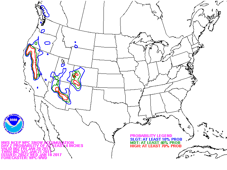
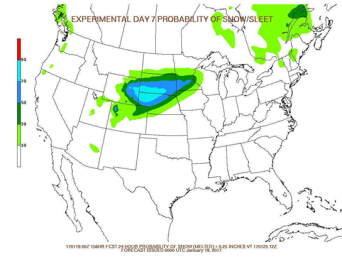
» Interactive Winter Weather Map (Day 1-3)
» Interactive Winter Weather Map (Day 4-7)
+ Forecast Discussion (Day 1-3)
+ Additional Links
» Interactive Winter Weather Map (Day 4-7)
+ Forecast Discussion (Day 1-3)
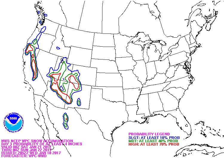
PROBABILISTIC HEAVY SNOW AND ICING DISCUSSION
NWS WEATHER PREDICTION CENTER COLLEGE PARK MD
420 PM EST WED JAN 18 2017

VALID 00Z THU JAN 19 2017 - 00Z SUN JAN 22 2017

FREEZING PRECIPITATION ACROSS THE INTERIOR OF
WASHINGTON/OREGON/IDAHO...

SOME FREEZING PRECIPITATION SHOULD BE LINGERING INTO THE EARLY
EVENING...BUT AMOUNTS APPROACHING THOSE WHICH FELL SINCE TUESDAY
ARE NOT EXPECTED.  THE COARSER RESOLUTION MODELS ARE PROBABLY
SCOURING OUT THE COLD AIR TOO QUICKLY...BUT THE TREND WILL BE FOR
WARMER AIR TO MAKE ITS WAY INTO THE INTERIOR PORTINO OF THE
NORTHWEST AND FOR PRECIPITATION INTENSITY TO WANE BEFORE ENDING.


SNOWFALL ACROSS THE NORTHWEST/CALIFORNIA/INTERMOUNTAIN
WEST/SOUTHERN ROCKIES...

PERIODIC HEAVY MOUNTAIN SNOW WILL OVERSPREAD THE REGION THE NEXT
SEVERAL DAYS AS THE LEADING EDGE OF THE UPPER TROUGH CURRENTLY
MOVING ASHORE SPLITS ACROSS THE INTERMOUNTAIN WEST AS ONE TROUGH
SPLITS WITH A SECOND ONE ON ITS HEELS. THROUGH FRIDAY...THE BEST
CHANCES OF SNOW WILL EXTEND FROM THE MOUNTAINS IN ID SOUTH THROUGH
GREAT BASIN AND FROM THE SHASTA/SISKIYOU MOUNTAINS SOUTH ALONG THE
ENTIRE LENGTH OF THE SIERRA/NEVADA MOUNTAINS AND INTO THE
TRANSVERSE RANGES IN SOUTHERN CA.  AS THE ENTIRE TROUGH MAKES ITS
WAY EASTWARD...SNOW SHOULD BE MAKING ITS WAY ACROSS THE MOGOLLON
RIM...SOUTHERN GREAT BASIN AND PARTS OF THE SOUTHERN ROCKIS BY THE
TIME THE FORECAST PERIOD ENDS LATE FRIDAY/EARLY SATURDAY.  SNOW
LEVELS SHOULD BE STARTING FAIRLY HIGH AHEAD OF THE MAIN TROUGH BUT
SETTLE TO AROUND 3000 FT IN THE NORTH TO AROUND 5000 FT IN THE
SOUTH. BY THIS TIME...THE 12Z ENSEMBLE MEMBERSHIP IS STILL EVENLY
DISTRIBUTED WITH THE SPREAD NEAR OR BELOW AVERAGE...SUGGESTING
ABOVE NORMAL CONFIDENCE IN THE AUTOMATED PROBABILITIES.

BANN
Medium Range Forecasts Legacy Page:
Valid 12Z Sat Jan 21, 2017
Valid 12Z Sun Jan 22, 2017
Valid 12Z Mon Jan 23, 2017
Valid 12Z Tue Jan 24, 2017
Valid 12Z Wed Jan 25, 2017
Image Options:


+ Forecast Discussion
+ Additional Links
EXTENDED FORECAST DISCUSSION
NWS WEATHER PREDICTION CENTER COLLEGE PARK MD
831 AM EST WED JAN 18 2017

VALID 12Z SAT JAN 21 2017 - 12Z WED JAN 25 2017

GENERAL FLOW PATTERN/GUIDANCE EVALUATION
~~~~~~~~~~~~~~~~~~~~~~~~~~~~~~~~~~~~~~~~
A BURGEONING POSITIVE ANOMALY ACROSS EASTERN CANADA FAVORS CLOSED
CYCLONES MOVING UNDER ITS BASE NEAR THE 40TH PARALLEL, WHICH IS
SEEN WITHIN THE AVAILABLE GUIDANCE.  OVERALL, THE GUIDANCE IS
QUITE AGREEABLE AND IN BETTER THAN AVERAGE AGREEMENT.  DETAIL
ISSUES REMAIN, AS USUAL.  TO DEAL WITH THESE, STARTED WITH THE
BLEND OF THE 00Z ECMWF, 00Z UKMET, 00Z CANADIAN, AND 06Z GFS FOR
THE SURFACE PRESSURES, FRONTS, AND 500 HPA HEIGHTS EARLY ON BEFORE
INCLUDING INCREASING AMOUNTS OF THE 00Z NAEFS MEAN AND 00Z ECMWF
ENSEMBLE MEAN SOLUTIONS.  THE TEMPERATURES, RAIN CHANCES, CLOUD,
WEATHER, AND DEW POINT GRIDS WILL BE MORE ENSEMBLE MEAN-HEAVY, AS
USUAL.  THE DAYS 4-7 QPF IS EXPECTED TO BE BASED ON A COMPROMISE
OF THE 00Z ECMWF/06Z GFS EARLY ON BEFORE LEANING MORE IN THE GFS
DIRECTION LATE AS IT AND THE CANADIAN MODEL APPEAR TO BE HANDLING
THE SYSTEM MOVING FROM THE EAST OUT INTO THE WESTERNMOST ATLANTIC
BETTER THAN THE OPERATIONAL ECMWF RUN.


WEATHER THREATS
~~~~~~~~~~~~~~~

WEST/PLAINS
~~~~~~~~~~~
THE MOST PRONOUNCED EFFECTS OF PACIFIC SYSTEMS SHOULD BE IN THE
SATURDAY NIGHT-MONDAY TIME FRAME.  THE HEAVIEST RAIN/HIGH
ELEVATION SNOWS SHOULD FIRST ARRIVE AT THE CENTRAL WEST COAST
BEFORE SHIFTING SOUTHWARD WITH TIME WITH THE BEST ONSHORE FLOW.
FAVORED COASTAL LOCATIONS AND SIERRA NEVADA RANGE MAY SEE UP TO
SEVERAL INCHES OF LIQUID EQUIVALENT PRECIPITATION.  STRONGEST
WINDS WILL LIKELY AFFECT THE CNTRL-NRN WEST COAST SATURDAY
NIGHT-SUNDAY. HIGHS WILL BE BELOW NORMAL OVER MUCH OF THE WEST
DURING THE PERIOD WITH SOME AREAS MORE THAN 10F COLDER THAN AVG ON
ONE OR MORE DAYS. AS THIS SYSTEM TRACKS NORTHEAST ACROSS THE
PLAINS, THERE WILL LIKELY BE A BAND OF SNOW TO THE NW OF THE LOW
TRACK.  THE PLAINS WHICH WILL BEGIN TO SEE SOME OF THE COOLER AIR
MOVE IN FROM THE WEST BY TUESDAY-WEDNESDAY. THE FCST IS CONSISTENT
WITH THE UPPER MS VALLEY REGION SEEING MULTIPLE DAYS OF MORNING
LOWS 30-40F ABOVE NORMAL WITH SOME RECORD WARM MINS.

SOUTHEAST/EAST
~~~~~~~~~~~~~~
AS THIS SYSTEM CROSSES THE CENTRAL AND EASTERN STATES, IT WILL BE
ACCOMPANIED BY A BROAD SHIELD OF PRECIPITATION WITH THE HEAVIEST
RAINS EXPECTED FROM THE EASTERN GULF COAST NORTHEAST ALONG THE
APPALACHIANS/EAST COAST.  CONSULT SPC OUTLOOKS FOR LATEST INFO
REGARDING POTENTIAL SEVERE WEATHER ALONG THE GULF COAST DURING THE
WEEKEND.  RAIN OVER THE EAST COAST STATES WILL BE ENHANCED BY
STRONG ATLANTIC INFLOW, BUT INSTABILITY SHOULD BE MINIMAL THE
FARTHER YOU GO NORTHWARD.  A RELATIVE MAXIMUM IN PRECIPITATION IS
ALSO EXPECTED FROM THE SOUTH-CENTRAL PLAINS INTO THE LOWER OH
VALLEY WITH A SYSTEM TAPPING LESSER AMOUNTS OF MOISTURE AS THE
POLAR FRONT REMAINS FARTHER SOUTHWARD.  PRECIPITATION TYPE STILL
LOOKS TO BE NEARLY ALL RAIN WITH ANY WINTRY WEATHER (SNOW AND
FREEZING RAIN) CONFINED TO NEW ENGLAND... AND LOCALLY WITH UPPER
LOWS.  ABOVE TO MUCH ABOVE NORMAL TEMPERATURES ASIDE FROM THE FL
PENINSULA ARE EXPECTED AFTER A WARM WEEKEND.

ROTH/RAUSCH
Forecast Tools (Prototype):
1/3/6/24-hr Changes

Change in weather parameters over the last 1/3/6/24 hours. The data used here is either from the Real-Time Mesoscale Analysis (RTMA) or the Rapid Refresh (RAP). The RTMA is shown at its native resolution of 2.5km and is used for surface variables. The RAP is shown at 32km (native resolution 13km) and is primarily used for non-surface (i.e., upper level) variables. For more information please see the RTMA or the RAP website.
GEFS Probabilities

This forecast product shows probabilistic information for the lower 48 states from the GEFS. This updates four times daily. Probabilities of exceeding or remaining less than such variables as precipitation, temperature, or sea-level pressure at various thresholds are displayed.
Links to Other Useful Forecast Tools
Meteorological Conversions and CalculationsStorm Prediction Center's Forecast Tools
Ensemble Situational Awareness Table


.jpg)