| 200 |  |
Setting up an observing tent to protect the instrument from the wind somewhere south of Monterey. |
California, Southern |
201 |  |
A triangulation station along the coast south of Monterey. Silk Hat Harry is on the right. |
California, Southern |
202 | 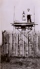 |
Floyd Risvold setup and ready to begin observations at a California-Mexico border monument. |
California-Mexico Border 1933 |
203 |  |
Setting up the observation tent at Station Malpaso. Note rocks anchoring observation stand. Strong winds and fog were the biggest adversaries at many stations along the California coast. |
California, Southern 1933 |
204 |  |
Station Malpaso - the "O" tent is up and the observation party is waiting for the fog to lift. They spent 6 days at Malpaso waiting for the fog to lift. |
California, Southern 1933 |
205 |  |
Triangulation station on the Navy radio station about 4 miles north of the Mexican border. |
California, Southern 1933 |
206 |  |
A plastic relief model made by a Braund Reliefograph developed by John Braund of the Coast and Geodetic Survey. Frontispiece to: Surveying and Mapping, Vol. IX, no. 3, pp. 183-186. |
Washington, D.C. |
207 |  |
Baseline measurement party erecting signal in Owens Valley. |
California, Owens Valley 1933 November |
208 |  |
Floyd Risvold and Silk Hat Harry Quinlavin sent to recover light left at Station Mt. Laurel in the high Sierra on the west side of Owens Valley unable to complete mission because of deep snow. This was at the end of truck travel before attempting to start up. |
California, Owens Valley 1933 November |
209 |  |
Party chief Lieutenant Jack Johnson in the high Sierra on the west side of Owens Valley, California. Attempting to head up to station Mt. Laurel during the first major snowstorm of the year. This part of the trail was very steep. |
California, Owens Valley 1933 November |
210 |  |
Silk Hat Harry Quinlavin and Floyd Risvold at about 9000 feet heading into the high Sierra to recover a signal lamp left at station Mt. Laurel. Trip was aborted because of deep snow. |
California, Owens Valley 1933 November |
211 |  |
Vic Smith and Dube Erickson at triangulation station along the 46th Parallel. The instrument was an old style theodolite that had to be physically lifted off its support to reverse it. |
Montana, 46th Parallel Survey 1934 July |
212 |  |
Headquarters camp of Lieutenant Ector B. Latham at Lolo Pass along the 46th Parallel. Triangulation operations. |
Montana, Lolo Pass 1934 |
213 |  |
Bill Husemeyer at the theodolite and Vic Smith sitting on instrument bow at a station along the 46th Parallel in Montana. |
Montana, 46th Parallel Survey 1934 |
214 |  |
Crossing stream with pack horses on way up Sheep Mountain. Bill Husemeyer and Cowboy Roy Bixby. |
Montana, Missoula National Forest 1934 July |
215 |  |
Rudy Kessler, Lou (for Louisiana), Henry Hottes, Jack Doherty, and Bill Husemeyer. |
Montana 1934 |
216 |  |
Station Tractor near Roundup, Montana. An 18 foot wooden tower. It took three occupations to get acceptable closure on angles at this station because of refraction problems. |
Montana 1934 |
217 |  |
A lightkeeper's leanto just below mountain station on 46th Parallel survey in Montana. A two hour climb from the end of truck travel. |
Montana, 46th Parallel Survey 1934 |
218 |  |
Showing light. Probably on the east side of the San Joaquin Valley in the foothills of the Sierra Nevada Mountains. Lieutenant John Bowie, Jr., Chief of Party. |
California 1931/32 |
219 |  |
A large wooden tower on an Arizona Station next to a water tank. Note palm trees. |
Arizona |
220 |  |
Probably the same wooden tower as seen from the water tank in image cgs00219. Bilby steel towers were not available to every triangulation party in the early 1930's. |
Arizona |
221 |  |
An unidentified triangulation station with tower, possibly in Arizona. |
Arizona |
222 |  |
The Point Loma Lighthouse, used as triangulation station. This is at the southern end of Point Loma and the site of Cabrillo National Monument. Charles Pierce, Chief of Party. |
California, San Diego 1933 October |
223 |  |
A triangulation station was located on the top of El Cortez Hotel, a familiar San Diego landmark that was built in 1927. Charles Pierce, Chief of Party. |
California, San Diego 1933 October |
224 |  |
Triangulation Party, Lieutenant Charles Pierce, Chief of Party. Standing L to R - Winnie Pierce, Claud Hayes, Charles Pierce, Silk Hat Harry Quinlavin, Clarence Olson. Front Row - Floyd Risvold, Henry Herch, George Talcell, and George Blair. |
California, San Diego 1933 November |
225 |  |
On the way to Station Tubac near Nogales, Arizona. Tubac was on the high peak. A one-hour pack for this observing party. |
Arizona, Nogales 1935 March 6. |
226 |  |
Panorama of Santa Catalina Mountains as seen from Tucson. Looking to north. |
Arizona, Tucson 1935 March |
227 |  |
West end of Santa Catalina Mountains as seen from Tucson. |
Arizona, Tucson 1935 March |
228 |  |
East end of Santa Catalina Mountains as seen from Tucson. |
Arizona, Tucson 1935 March |
229 |  |
Packing off of Station Well near Randsburg, California. Near present day U.S. 395 in China Lake area. Building party returning. Party of Lieutenant Jack Johnson. |
California, Randsburg 1933 November |
230 |  |
Station Offset No. 135. In camp at Los Tres Bellotas (The Three Acorns) ranch, 1/2 mile north of the Mexican border. Lieutenant Ector B. Latham, Chief of Party. |
Arizona/Mexico border area 1935 March 15 |
231 |  |
The storm that drove us out of Montana. Late 1934. Party of Lieutenant Ector B. Latham, 46th Parallel Survey. |
Montana, 46th Parallel Survey 1934 Fall |
232 |  |
Cowboy Roy Bixby has the horses packed and ready to head out of the high country. The storm that drove us out of Montana. Lieutenant Ector B. Latham, 46th Parallel Survey. |
Montana, 46th Parallel Survey 1934 Fall |
233 |  |
Cowboy Roy Bixby leads string of pack horses out of the high country. The storm that drove us out of Montana. Lieutenant Ector B. Latham, 46th Parallel Survey. |
Montana, 46th Parallel Survey 1934 Fall |
234 |  |
Camp at Stockton in the San Joaquin Valley. |
California, San Joaquin Valley 1931-32 Winter |
235 |  |
Dube Erickson stamping name of station on geodetic marker. |
California, San Francisco Bay area 1931-32 Winter |
236 |  |
Jan, Tex, and Norm Sylar setting up observation tent on Angel Island. |
California, Angel Island, San Francisco Bay 1932 March |
237 |  |
Station Nelson located on Mount Nelson in the distance. A three hour pack. Near Helena, Montana. Lieutenant Ector B. Latham, Chief of Party. |
Montana, Near Helena 1934 Summer |
238 |  |
Shadows cast on nearby mountains by observing party on a high peak at Station Kent. Lieutenant Jack Johnson, Chief of Party. |
New Mexico, Near Las Cruces 1934 February |
239 |  |
Mountains as seen from Station Line. Lieutenant Jack Johnson, Chief of Party. |
New Mexico 1934 March |
240 |  |
Cliff Lamb and Dick Donaldson at Station El Paso near Randsburg. |
California, Randsburg 1933 November |
241 |  |
Back row: Cliff Lamb, Dick Donaldson, Bob Garvie. Front row: W. E. Bussey, and Dee Phillips at Station El Paso near Randsburg. |
California, Randsburg 1933 November |
242 |  |
Floyd Risvold on top of cairn marking station El Paso near Randsburg. |
California, Randsburg 1933 November |
243 |  |
The trail up to Station Madden on the top of Madden Peak, 11972 feet, in southwest Colorado. |
Colorado, Near Durango 1934 June 17 |
244 |  |
Setting up the observing tent at Station Madden at 11, 972 feet in southwest Colorado. Mount Hesperus is the high peak in the background. |
Colorado, Near Durango 1934 June 17 |
245 |  |
Observing party at the Kaibab Mine on Madden Peak. Person in foreground is Mrs. Little, a famous woman packer of the southwest Colorado region. |
Colorado, Near Durango 1934 June 17 |
246 |  |
The camp at Sacramento. Lieutenant John Bowie, Jr., Chief of Party. |
California, Sacramento 1931-32 Winter |
247 |  |
The camp at Sacramento. Lieutenant John Bowie, Jr., Chief of Party. |
California, Sacramento 1931-32 Winter |
248 |  |
The camp at Sacramento. Lieutenant John Bowie, Jr., Chief of Party. |
California, Sacramento 1931-32 Winter |
249 |  |
Lieutenant George Anderson doing observing headed a three-man crew ordered to geodetically locate all of the airplane beacons that showed out to sea. Roy Sylar was the truck driver and umbrella holder for the party. |
California coastline 1932 |

