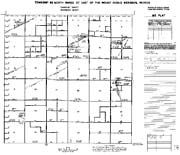
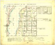
Master Title Plats, Use Plats, and Historical Indices are known as “Title Records”. Master Title Plats (MTP) and Use Plats are a composite diagram for a given township. Depicted on these plats are limited cadastral survey information, ownership information, land status information, restrictions, use authorizations, etc. MTP’s show the land which has been patented, patent numbers, lotting and lotting areas from cadastral survey plats, reservations to the United States as stated in the patent, and land that is still classified as vacant Federal Land…often called Public Land and/or Public Domain. Withdrawals, rights-of-way, National Forest Lands, Indian Country Reservations, Wildlife Refuges, and other similar reservations and actions are also shown. Use Plat is the name assigned to a MTP which in addition to the MTP information, displays mineral leases and permits, and applications for mineral leases and permits issued by BLM, i.e. oil & gas, geothermal, coal, etc. The title information on the Use Plat should be identical to that on the MTP. Each township will have an MTP associated with it, but may not have a Use Plat. Historical Indices provide a history of the land status by identifying all past and present actions that affect title to Federal lands and is recorded in chronological order.
In addition to Title Records, the Nevada “official” survey plats, entry surveys, mineral surveys, mineral connecting sheets, townsite surveys, etc., as well as the survey field notes have been scanned. Currently 12,468 plats and 343,675 pages of field notes exist and will be available to the public on-line. As “official” surveys are completed by the Cadastral Survey Program, they will be added to the site. At this time, users can access the Title Records and many Survey Records from any one of the nine BLM Information Access Centers located in Battle Mountain, Caliente, Carson City, Elko, Ely, Las Vegas, Reno, Tonopah and Winnemucca, or through BLM Nevada’s official “Public Land Records” site: NEVADA'S LAND RECORDS