Northern Rocky Mountain Science Center (NOROCK)
Home | About Us | Science | Product Library | News & Events | Staff | Students | Partners | Contact Us
Northern Rocky Mountain Science Center (NOROCK)
Home | About Us | Science | Product Library | News & Events | Staff | Students | Partners | Contact Us
Geographer
Home
Research Projects
Publications
Phone: 406-888-7991
Fax: 406-888-5835
Email: carl_key@usgs.gov
|
2000 |
2003 |
2007 |
 |
 |
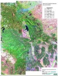 |
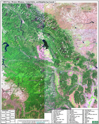
Due to the amount of recent wildfire activity, it becomes increasingly difficult to remember all the fires and when they occurred, let alone their distribution across the region. The above mosaics are intended to assist by providing the location of notable burns for the more significant fire years in western Montana and central Idaho. The aim is also to provide a general sense of the amount and distribution of burned area, and how fire patterns relate to surrounding landscapes over time. The mosaics are just an overview, however; reference snapshots that hopefully lead to further inquiry. They are simply comprised of multiple Landsat browse images, which have a nominal resolution of 240 meters. Browse images can be reviewed and downloaded from the USGS Global Visualization Viewer. Fire names and locations were obtained via the Incident Information System, the USGS GeoMac site, and from personal contacts and knowledge. The mosaics are not constructed with any consistent positional or geographic map accuracy. They are intended for visualization and relational purposes only. Further information is available for most fires from a variety of web sites, including archived incident reports during the fire, and post-fire assessment and mapping data.
Click on the above images to access PDF versions of maps.