|
|
Processing the Data Obtained from MISR
Contents:
As part of NASA's Earth Observing System (EOS), data from MISR is transmitted
from the Terra spacecraft to the ground, where it is handled by the EOS
Data and Information System (EOSDIS). EOSDIS is an extensive ground
data system set up to manage the data from all of NASA's current Earth
science research satellites. It's functions include controlling the spacecraft
and its instruments, processing the instrument data into products useful
for scientists, distributing those products, and archiving all the data
and products.
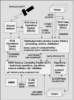 EOS
instrument data received by ground stations in New Mexico, Alaska, or
Norway are passed to the EOS Data and Operations Center (EDOS) at NASA's
Goddard Space Flight Center in Maryland, where they are checked
and divided into separate data streams, depending on the data type and
destination. Science data are then forwarded to several sites across the
United States, known as as Distributed Active Archive Centers (DAACs),
where the data are processed into products, distributed, and archived..
The DAAC that handles MISR data is within the Atmospheric
Sciences Data Center (ASDC) at NASA's Langley Research Center in Virginia.
The software for converting MISR data into usable science products is
developed by the MISR Project staff at the Jet Propulsion Laboratory (JPL)
in California and provided to the ASDC for operational use. The MISR staff
at JPL work closely with the ASDC staff to ensure MISR data products are
produced in the desired order and with the required quality. EOS
instrument data received by ground stations in New Mexico, Alaska, or
Norway are passed to the EOS Data and Operations Center (EDOS) at NASA's
Goddard Space Flight Center in Maryland, where they are checked
and divided into separate data streams, depending on the data type and
destination. Science data are then forwarded to several sites across the
United States, known as as Distributed Active Archive Centers (DAACs),
where the data are processed into products, distributed, and archived..
The DAAC that handles MISR data is within the Atmospheric
Sciences Data Center (ASDC) at NASA's Langley Research Center in Virginia.
The software for converting MISR data into usable science products is
developed by the MISR Project staff at the Jet Propulsion Laboratory (JPL)
in California and provided to the ASDC for operational use. The MISR staff
at JPL work closely with the ASDC staff to ensure MISR data products are
produced in the desired order and with the required quality.
 In
addition to the processing of MISR data, the ASDC archives and distributes
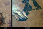
data products from a MISR airborne simulator called AirMISR.
The ASDC also processes and manages the data from several other EOS instruments. In
addition to the processing of MISR data, the ASDC archives and distributes
data products from a MISR airborne simulator called AirMISR.
The ASDC also processes and manages the data from several other EOS instruments.
Scientists interested in obtaining MISR data products should visit the
ASDC's web site, http://eosweb.larc.nasa.gov.
Return to top
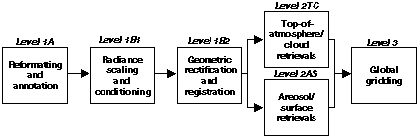
The generation of MISR science data products can be divided into five
production steps, as illustrated above. It is convenient to think of these
five steps as occurring in sequence, with the predecessor producing at
least one complete product, a portion of which is the primary input for
the successor. These steps are grouped into three "Levels",
1, 2, and 3. Level 1 processing provides corrected (or calibrated) instrument
data. Level 2 processing provides retrieval of derived scientific quantities,
such as atmospheric aerosol and cloud measurements. Level 3 processing
produces global maps. Here is more detail about the individual products.
- Level 1 Products
- These have been processed and calibrated to remove many of the instrument
effects. The resulting products thus contain minimal instrument or spacecraft
artifacts and are most suitable for subsequent scientific derivations.
-
- Level 1A: Reformatted Product
- The raw data from the instrument, which is intricately structured
and compressed, is reformatted into more straightforward computer
files. At the same time, many checks are made on the quality of
the data to ensure that the instrument is working correctly.
-
- Level 1B1: Radiometric Product
- Two types of processing are included in this product. Firstly,
the Radiance Scaling operation converts the camera's digital output
to a measure of energy incident on the front optical surface. The
measurement is expressed in units called radiance (energy per unit
area, wavelength, and solid angle) as defined by the an international
scale. Secondly, Radiance Conditioning modifies the radiances to
remove instrument-dependent effects. Specifically, image sharpening
is provided, and focal-plane scattering is removed. Additionally,
all radiances are adjusted to remove slight spectral sensitivity
differences among the 1504 detector elements of each spectral band
and each camera.
-
- Level 1B2: Georectified Radiance Product
- The nine sets of imagery from the nine cameras are registered to one another and to the ground.
This is an image processing application made necessary because the nine views of each point on the
ground are not acquired simultaneously (images from cameras at the two
extreme angles are 7 minutes apart.) This product is mapped into
a standard map projection called Space Oblique Mercator (SOM). There
is a cloud mask derived as part of the Level 1B2, called thte Radiometric
Camera-by-camera Cloud Mask (RCCM). (Other types of cloud mask form
part of the Level 2 products.)
-
- Local Mode Product
-
MISR
is capable of taking image data in two different spatial resolution
modes. In Local Mode, selected targets of 300 kilometers long are
observed at the maximum resolution of 275 meters (pixel to pixel) in
all cameras. Local Mode data target sites and acquisition history is
available here.
-
Level 2 Products
- These are geophysical measurements derived from the instrument data.
-
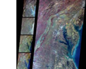
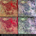
- Level 2 Top-of-Atmosphere/Cloud Product

- This contains measurements of cloud heights and winds, cloud
texture, top-of-atmosphere albedos and bidirectional reflectance
factors, and other related parameters. Click the thumbnail
image at the right to see what this product looks like.
-
- Level 2 Aerosol/Surface Product

- This products includes a range of parameters such as tropospheric
aerosol optical depth; aerosol composition and size; surface directional
reflectance factors and bi-hemispherical reflectance; and other
related parameters. Click the thumbnail
image at the right to see an example of what this product looks
like.
Level 3 Products
- These are global maps of various parameter elements from the Level 2
products. The maps are produced monthly, seasonally (every three months),
and annually. Visualization
of select MISR Level 3 data is now available.
The Levels 1 and 2 products are in swaths, each derived from a single MISR
orbit, where the imagery is 360 km wide and approximately 20,000 km long.
Return to top
Implementing the MISR data products
The MISR Science Team currently consists
of 17 members. Some are collocated with the MISR Project at JPL, but most
are located at other facilities, such as universities, both in the United
States and Europe. The Science Team provides the scientific algorithms,
i.e. the scientific methods, used by the MISR Project staff to implement
the software used in production of data products at the ASDC. The Science
Team is also responsible for validating that the products contain the
correct scientific content. This validation activity
is described elsewhere on this web site.
At JPL, the MISR Project Staff base their development around a computing
center known as the MISR Science Computing Facility (SCF). There is a
high-speed on-line connection between the SCF and the ASDC/DAAC at NASA
Langley. Production at the ASDC uses several Silicon Graphics Inc. (SGI)
computers with a total of approximately 128 processors. For archiving purposes,
the ASDC has on-line tape libraries with a total capacity of approximately
400 Terabytes to accommodate MISR data for the duration of the Terra mission.
The release of each data product goes through four stages: Alpha,
Beta, Provisional, and Validated.
MISR products are first released publicly at the Beta stage, and then
progress through the Provisional to the Validated stage. MISR's Beta
products became available in July 2000 for Level 1 and in March 2001
for Level 2 products. The initial Level 3 Beta products will be
available in late 2001. The primary Level 2 products reached the first
stage of Validated status by late 2003.
Return to top
Next: Access MISR data
|


