Glacier and Landscape Change in Response to Changing Climate
 |
Repeat photography is a technique in which a historical photograph and a modern photograph, both having the same field of view, are compared and contrasted to quantitatively and qualitatively determine their similarities and differences. The following sections depict how this technique was used at a number of locations in Alaska, including Glacier Bay National Park and Preserve, Kenai Fjords National Park, and the northwestern Prince William Sound area of the Chugach National Forest, to document and understand changes to glaciers and landscapes as a result of changing climate. Through analysis and interpretation of these photographic pairs, information is extracted to document Alaskan landscape evolution and glacier dynamics for the last century-and-a-quarter on local and regional scales and the response of the Alaskan landscape to retreating glacier ice.
This images used on this Web site are available for public domain and do not require permission from the U.S. Geological Survey for use. See USGS Policy -- Copyrights and Credits for additional information on crediting the USGS.
| Muir Glacier and Inlet | ||||
 September 2, 1892 High Resolution image |
 August 11, 2005 High Resolution image |
A pair of northeast looking photographs, both taken from the same location on the west shoreline of Muir Inlet, Glacier Bay National Park and Preserve, Alaska showing the changes that have occurred to Muir Glacier during the 113 years between September 2, 1892 and August 11, 2005. The 1892 photograph shows the more than 100-meter (328-feet) high, more than 4 kilometers (2.5 miles) wide tidewater terminus of the glacier with a face capped by angular séracs. Some icebergs, evidence of recent calving, can be seen floating in Muir Inlet. The mountain located right-of-center is Mount Wright. Mount Case is in the background. Note the absence of vegetation. (H. F. Reid photograph, muir1892_417, courtesy of National Snow and Ice Data Center). In the 2005 photograph, Muir Glacier is no longer visible, as it has retreated more than 50 kilometers (31 miles). During the interval between photographs, Muir Glacier ceased to have a tidewater terminus. Note the lack of floating ice and the abundant vegetation on many slopes throughout the photograph. (USGS Photograph by Bruce F. Molnia). |
||
 Between 1880s – 1890s High Resolution image |
 August 11, 2005 High Resolution image |
A pair of northwest looking photographs, both taken from the same location on the east shoreline of Muir Inlet, Glacier Bay National Park and Preserve, Alaska showing the changes that have occurred to Muir Glacier during a period of more than a century, between 1880s – 1890s date of the black-and-white photograph and August 11, 2005. The early photograph shows the more than 100-meters (328-feet) -high tidewater terminus of the glacier with a face capped by angular séracs. Numerous icebergs, some more than 2 meters (6.6 feet) in diameter are grounded on the tidal flat in the fore- and middle-ground of the photograph. The tidal flat is probably ice cored, underlain by glacier ice. The tides in this area are greater than 3 m (9.9 feet). A photographer and seven tourists are exploring the icebergs. Note the formal dress of the people in the photograph, including the bustle on the woman on the right and the bowler hat and morning coat on the photographer. Many late-19th century photographs of Muir Glacier were made by tourists. Information associated with this photograph attributes it to a photographer named G. D. Hazard. Hazard may have been a camera-carrying passenger on one of the steamers that visited Glacier Bay. Tops of several bedrock ridges just poke above the top of the glacier on the skyline on the right side of the photograph. (G. D. Hazard, 7807, courtesy of Glacier Bay National Park and Preserve Archive). By the date of the 2005 photograph, Muir Glacier has retreated more than 50 kilometers (31 miles) and is completely out of the field of view. The glacier in the distance to the right center of the photograph is Riggs Glacier. Formerly a tributary to Muir Glacier, it is approximately 40 kilometers (26 miles) from the late-19th century photo point and about 10 kilometers (6.2 miles) from Muir Glacier. The beach in the foreground is covered by a cobble and pebble lag deposit, which was winnowed from sediment that was deposited by Muir Glacier and by melting grounded icebergs. Many of the cobbles are covered by barnacles. Note the abundant vegetation on the west side of the inlet. (USGS Photograph by Bruce F. Molnia). |
||
 Mid-1890s High Resolution image |
 August 11, 2005 High Resolution image |
A pair of northeast looking photographs, both taken from the same location on the west shoreline of Muir Inlet, Glacier Bay National Park and Preserve, Alaska showing the changes that have occurred to Muir Glacier during a period of more than a century, between the late-19th century and August 11, 2005. The late-19th century photograph, actually a postcard, shows the approximately 100-meters (328-feet)-high tidewater terminus of the glacier with a face capped by angular séracs. The eastern part of Muir Glacier’s terminus is composed of ice contributed by Adams Glacier, flowing out of what is now Adams Inlet, located in the gap between the essentially-snow-free mountains in the center of the picture. Numerous icebergs, some more than 5 meters (16 feet) in diameter, are grounded in the shallow water in the foreground of the photograph. Photographs used on many late-19th and early 20th-century postcards, including this one, were airbrushed to simplify the complex topography of the image’s mountains. No vegetation is visible. (L.V. Winter and P. E. Pond, postcard # C141 in the personal collection of the author). In the roughly 105-110 years between photographs, Muir Glacier has retreated more than 50 kilometers (31 miles) and is completely out of the field of view. The angular rocks in the foreground are part of a cobble lag deposit winnowed from sediment previously deposited by Muir Glacier and by melting grounded icebergs. Note the abundant vegetation on the near-ground slopes on the east side of Muir Inlet and in the lower part of Adams Inlet. (USGS Photograph by Bruce F. Molnia). |
||
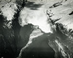
 Late 19th century High Resolution image |
 August 11, 2005 High Resolution image |
A pair of northeast looking photographs, both taken from the same location on the west shoreline of Muir Inlet, Glacier Bay National Park and Preserve, Alaska showing the changes that have occurred to Muir Glacier during a period of more than a century, between the late-19th century and August 11, 2005. The late-19th century photograph, actually a postcard, shows the approximately 100-m-high tidewater terminus of the glacier with a face capped by angular séracs. The eastern part of Muir Glacier’s terminus is composed of ice contributed by Adams Glacier, flowing out of what is now Adams Inlet, located in the gap between the essentially-snow-free mountains in the center of the picture. Numerous icebergs, some more than 5 m in diameter, are grounded in the shallow water in the foreground of the photograph. Photographs used on many late-19th and early 20th-century postcards, including this one, were airbrushed to simplify the complex topography of the image’s mountains. No vegetation is visible. (L.V. Winter and P. E. Pond, postcard # C141 in the personal collection of the author). In the roughly 105-110 years between photographs, Muir Glacier has retreated more than 50 km and is completely out of the field of view. The angular rocks in the foreground are part of a cobble lag deposit winnowed from sediment previously deposited by Muir Glacier and by melting grounded icebergs. Note the abundant vegetation on the near-ground slopes on the east side of Muir Inlet and in the lower part of Adams Inlet. (USGS Photograph by Bruce F. Molnia). |
||
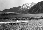
 June 1895 High Resolution image |
 August 28, 2004 High Resolution image |
|
||
 June 1899 High Resolution image Flash Movie -- 1899 - 2003 |
 September 2003 High Resolution image |
A pair of north-looking photographs, both taken from the same shoreline location near Muir Point, Muir Inlet, Glacier Bay National Park and Preserve, Alaska, that document changes that have occurred during the 104 years between June 1899 and September 2003. The 1899 photograph by Grove Karl Gilbert shows the calving terminus of Muir Glacier extending almost to the photo point and the absence of any identifiable vegetation (USGS Photo Library Photograph - Gilbert 276). The 2003 photograph documents the disappearance of Muir Glacier from the field of view. The distant glacier at the extreme right is Rigs Glacier, more than 30 kilometers (20 miles) to the north. Since 1899, Muir Glacier retreated more than 40 kilometers (25 miles). Note the extensive vegetation that has developed. (USGS Photograph by Bruce F. Molnia). | ||
 June 1899 High Resolution image Flash Movie -- 1899 - 2003 |
 September 2003 High Resolution image |
A pair of northeast-looking photographs, both taken from the same shoreline location near Muir Point, Muir Inlet, Glacier Bay National Park and Preserve, Alaska, that document changes that have occurred during the 104 years between June 1899 and September 2003. The 1899 photograph by Grove Karl Gilbert shows the calving terminus of Muir Glacier, near its confluence with Adams Glacier. No vegetation is visible (USGS Photo Library Photograph - Gilbert 278). The 2003 photograph documents the disappearance of Muir and Adams Glaciers from the field of view. Muir Glacier has retreated more than 40 kilometers (25 miles) to the north. Note the extensive vegetation that has developed. (USGS Photograph by Bruce F. Molnia). | ||
 August 13, 1941 High Resolution image  August 31, 2004 High Resolution image |
 August 4, 1950 High Resolution image |
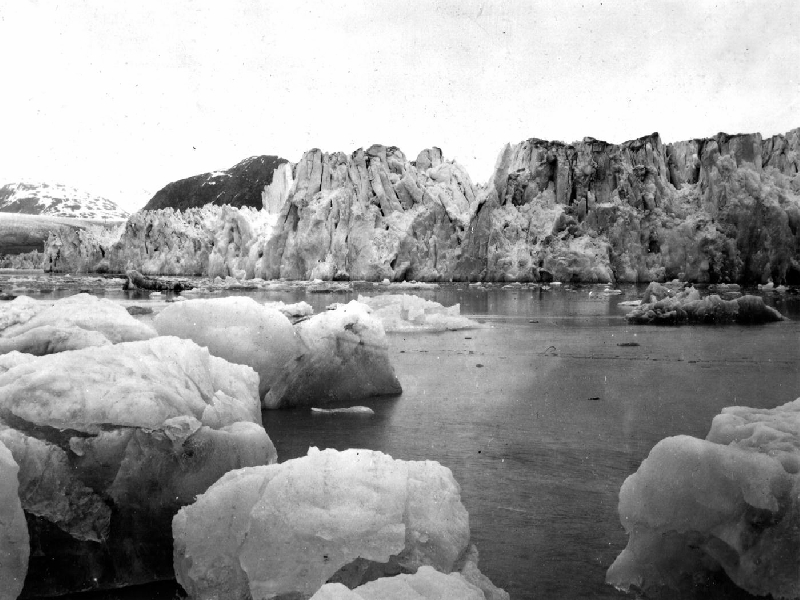
Three northeast-looking photographs taken from a Glacier Bay Photo station that was established in 1941 by William O. Field on White Thunder Ridge, Muir Inlet, Glacier Bay National Park and Preserve, Alaska. The three photographs document the significant changes that have occurred during the 63 years between August 13, 1941 and August 31, 2004. The 1941 photograph shows the lower reaches of Muir Glacier, then a large, tidewater calving valley glacier and its tributary Riggs Glacier. Muir and Riggs Glaciers filled Muir Inlet. The séracs in the lower right-hand corner of the photograph mark the location of Muir Glacier’s terminus. The ice thickness in the center of the photographs is more than 0.7 kilometers (0.43 miles). For nearly two centuries prior to 1941, Muir Glacier had been retreating. Maximum retreat exceeded 50 kilometers (31 miles). In places, more than a 1.0 kilometer (0.62 mile) thickness of ice had been lost. Note the absence of any identifiable vegetation and the numerous bare bedrock faces present on both sides of the glacier (W. O. Field, # 41-64, courtesy of the National Snow and Ice Data Center and Glacier Bay National Park and Preserve Archive). The August 4, 1950 photograph, the first of two repeat photographs documents the significant changes that have occurred during the 9 years between it and the 1941 photograph. Muir Glacier has retreated more than 3 kilometers (1.9 miles), exposing Muir Inlet, and thinned 100 meters (328 feet) or more. However, it still is connected with tributary Riggs Glacier. White Thunder Ridge continues to be devoid of vegetation. In places, erosion has removed some of the till from its surface. (W. O. Field, # F50-R29, courtesy of the Glacier Bay National Park and Preserve Archive). The August 31, 2004 photograph, the second repeat photograph, documents the significant changes that have occurred during the 63 years between the first and third photographs and during the 54 years between second and third photographs. Muir Glacier has retreated out of the field of view and is now located more than 7 kilometers (4.4 miles) to the northwest. Riggs Glacier has retreated as much as 0.6 kilometers (0.37 miles) and thinned by more than 0.25 kilometers (0.16 miles). Note the dense vegetation, dominated by Alnus, that has developed on the till cover of White Thunder Ridge. Also note the correlation between Muir Glacier’s 1941 thickness and the trimline on the left side of the 2004 photograph. (USGS Photograph by Bruce F. Molnia). | ||
 August 15, 1976 High Resolution image |
 September 8, 2003 High Resolution image |
A pair of north-looking photographs, both taken from the same shoreline location in upper Muir Inlet, Glacier Bay National Park and Preserve, Alaska, that document changes that have occurred during the 27 years between August 15, 1976 and September 8, 2003. The 1976 photograph shows the calving terminus of Muir Glacier extending the width of the fiord. A thinning tributary flows in the valley to its north. Aside from algae growing on a lighter colored dike, there is no vegetation visible in the photograph (1976 USGS Photograph by Bruce F. Molnia). The 2003 photograph documents the disappearance of Muir Glacier from the field of view. The two small cirque glaciers at the upper left have probably not been connected to Muir glacier. Muir Glacier has retreated about 10 kilometers (6.2 miles) to the north. Note that vegetation is beginning to develop. (USGS Photograph by Bruce F. Molnia). | ||
 August 28, 1980 High Resolution image |
 September 8, 2003 High Resolution image |
Two north-northwest looking ship-deck-based photographs that show changes in Muir Glacier and Muir Inlet, Glacier Bay National Park and Preserve, St. Elias Mountains, Alaska, between August 28, 1980 and September 8, 2003, The 1980 photograph show the nearly 50-meters (164-foot)-high retreating tidewater terminus of Muir Glacier with part of its face capped by a few angular séracs. Note the icebergs, especially in the smoother, arcuate ship’s wake in the lower right side of the photograph. The location of Muir’s terminus is less than 1.0 kilometer (0.62 miles) from the landward end of Muir Inlet. (USGS photograph by Bruce F. Molnia) The September 7, 2003, taken 23 years later, documents that Muir Glacier has retreated more than 2 kilometers (1.24 miles) and ceased to have a tidewater terminus. Note that the retreat of Muir Glacier has left several ice-cored morainal mounds between the shoreline and the terminus. Since 1980, Muir Glacier has thinned by several hundred meters (more than 700 feet) permitting a view of a mountain with a summit elevation of greater than 1,500 meters (4,920 feet), located in the center of the photograph. A careful examination of the 1980 photograph shows that the summit of this mountain was visible but that it blended in with adjacent clouds. No evidence of vegetation is seen anywhere in the photograph. (USGS Photograph by Bruce F. Molnia). | ||
| Reid Glacier | ||||
 June 10, 1899 High Resolution image |
 September 6, 2003 High Resolution image |
A pair of northwest looking photographs, both taken from the same location on the southwest side of Reid Inlet, Glacier Bay National Park and Preserve, Alaska, showing the changes that have occurred to Reid Glacier during a period of more than a century, between June 10, 1899 and September 6, 2003. The 1899 photograph is taken towards the northwest and shows the approximately 60-meter (197-foot)-high tidewater terminus of the then retreating Reid Glacier. The glacier terminus is adjacent to the mouth of Reid Inlet. The hillside in the foreground is covered by a few centimeters (few inches) of snow. No trees are present on the hillside or on any other surface in the field of view. A few icebergs of various sizes are floating in the water in front of the glacier. A large block of grounded glacier ice is located adjacent to the snow-covered slope in the left middle-ground of the photograph. It appears to have recently separated from the body of the retreating glacier and is stranded adjacent to the shoreline of the inlet. The concentric ripples suggest that a large calving event has recently occurred at the terminus to the right of the stranded ice. (G. K. Gilbert, 258, courtesy of the USGS Photographic Library). In the 104 years between photographs, Reid Glacier has retreated about 3 kilometers (1.9 miles) and is just visible at the head of the fiord on the left side of the field of view. The hillside in the foreground is covered with dense vegetation, including both conifers and deciduous trees. Vegetation, predominantly alder, covers much of the lower slopes on the opposite side of the inlet. Nearly all of the trees are rooted in glacier till. Species present include Alnus (alder), Salix (willow), and Populus (cottonwood). The spit in the foreground is part of the recessional moraine deposited by Reid Glacier when it sat at the mouth of its fiord during the early 20th century. (USGS Photograph by Bruce F. Molnia). | ||
 August 13, 1924 High Resolution image  September 6, 2003 High Resolution image |
 August 29, 1941 High Resolution image |
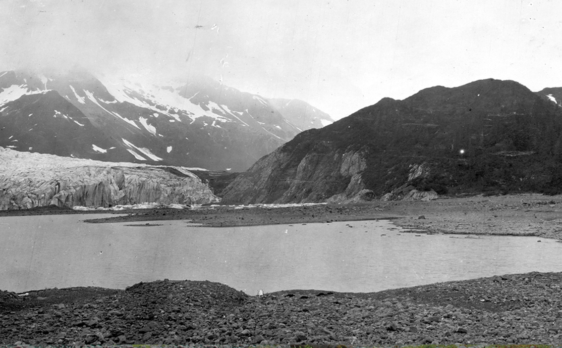
Three north looking photographs, all taken from the same location at the mouth of Reid Inlet, Glacier Bay National Park and Preserve, Alaska, showing the changes that have occurred to Reid Glacier and Inlet during a period of 79 years, between August 13, 1924 and September 6, 2003. The 1924 photograph shows the approximately 50-meter (164 foot)-high tidewater terminus of the then retreating Reid Glacier. The terminus of the glacier spans the width of Reid Inlet. In the 25-year period between 1899 and 1924, Reid Glacier retreated about 1.5 kilometers (0.93 miles) from the mouth of Reid Inlet. If vegetation is present, it cannot be seen on this photograph. A few icebergs of various sizes are floating in the inlet. (A. H. Brooks, 1299, courtesy of the USGS Photographic Library). In the second photograph, taken on August 29, 1941, the retreating, approximately 30-meter (98 foot)-high terminus of Reid Glacier, which previously spanned the width of Reid Inlet, is now barely half as wide. Its southern margin has retreated above tidewater and continues to retreat by melting. Part of the fiord-mouth spit, an early 20th century recessional moraine deposit, is visible in the foreground. In the 17 years between 1924 and 1941, Reid Glacier retreated another 1.5 kilometers (0.93 miles). If vegetation is present, it cannot be seen on this photograph. The grounded icebergs and the exposed surface of the spit suggest that the photograph was made at low tide. (W. O. Field, F41-80, courtesy of the National Snow and Ice Data Center). Between 1941 and 2003, the terminus of Reid Glacier has retreated only a few hundred meters (less than a thousand feet). Note the reduction in the number and size of icebergs floating in the inlet. Many boulders on the recessional moraine spit in the foreground are now covered by marine algae. The algae’s chance of survival has increased as the number of icebergs that could scour it from the surface of these lag boulders has decreased. (USGS Photograph by Bruce F. Molnia). | ||
| Lamplugh Glacier | ||||
 August 1941 High Resolution image |
 September 8, 2003 High Resolution image |
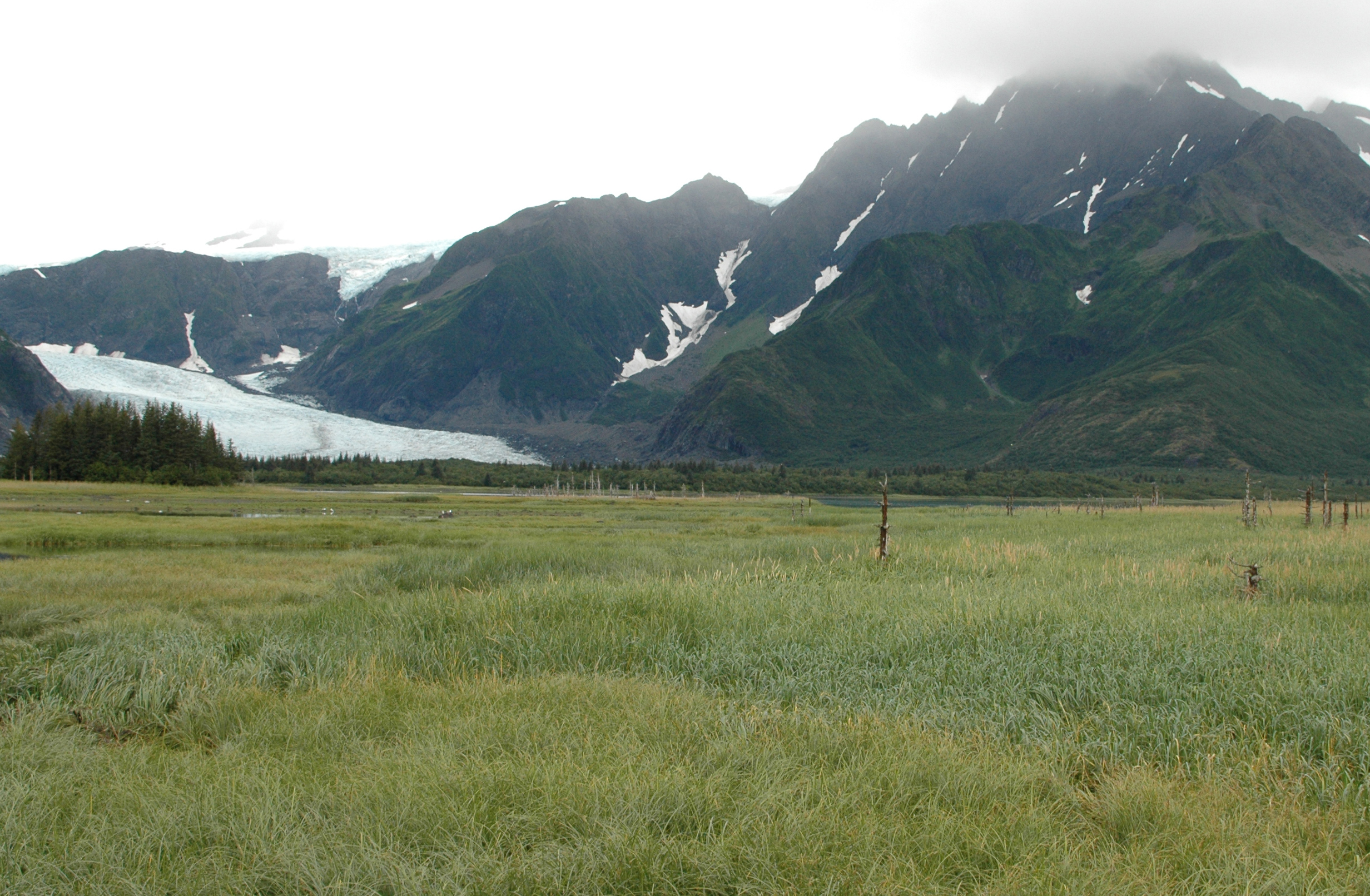
A pair of southwest-looking photographs, both taken from the same location adjacent to Lamplugh Glacier showing the changes which have occurred at the lower end of Lamplugh’s inlet during the 62 years between August 1941 and September 8, 2003. The 1941 photograph by William O. Field shows the calving terminus of Lamplugh Glacier extending to within (0.8 kilometers) 0.5 miles of the photo point (Field photograph # 430-41). No vegetation is visible. The 2003 photograph shows that the terminus of Lamplugh Glacier is more than 0.5 kilometers (0.3 miles) forward of its 1941 position. Additionally, glacial sediment on the bedrock ridge in the foreground indicates that Lamplugh Glacier had advanced beyond the photo point at some time during the interval between photographs, probably in the late -1960s. Note the isolated vegetation. (USGS Photograph by Bruce F. Molnia). | ||
| Carroll Glacier | ||||
 August 1906 High Resolution image Flash Movie -- 1899 - 2003 |
 September 7, 2003 High Resolution image |
A pair of north-looking photographs, both taken from the same location on Triangle Island, Queen Inlet, Glacier Bay National Park and Preserve, Alaska, showing the changes that have occurred to Carroll Glacier and upper Queen Inlet during the 97 years between August 1906 and September 7, 2003. The 1906 photograph, by USGS Geologist Charles Will Wright, shows the calving terminus of Carroll Glacier sitting at the head of Queen Inlet (USGS Photo Library Photograph - Wright 333). No vegetation is visible. The 2003 photograph shows that the terminus of Carroll Glacier has changed to a stagnant, debris-covered glacier that has significantly thinned and retreated from its 1906 position. The head of Queen Inlet has been filled by sediment. An examination of early 20th century nautical charts suggests that the sediment fill exceeds 125 meters (410 feet). Note the developing vegetation on the island. (USGS Photograph by Bruce F. Molnia). |
||
 August 1906 High Resolution image |
 June 21, 2004 High Resolution image |
A pair of northwest-looking photographs, both taken from the same location, several hundred meters (about 650 feet) up a steep alluvial fan located in a side valley on the east side of Queen Inlet, Glacier Bay National Park and Preserve, Alaska, showing the changes that have occurred to Carroll Glacier and upper Queen Inlet during the 98 years between August 1906 and June 21, 2004. The 1906 photograph by Charles Will Wright shows the calving terminus of Carroll Glacier sitting at the head of Queen Inlet. No vegetation is visible. (USGS Photo Library Photograph - Wright 333) The 2004 photograph shows that the terminus of Carroll Glacier has changed to a stagnant, debris-covered glacier that has significantly thinned and retreated from its 1906 position. The head of Queen Inlet has been filled by sediment. An examination of early 20th century nautical charts suggests that the sediment fill exceeds 125 meters (410 feet). Note the developing vegetation on the sediment fill. (USGS Photograph by Bruce F. Molnia). | ||
| Plateau Glacier | ||||
 September 9, 1961 High Resolution image |
 September 14, 2003 High Resolution image |
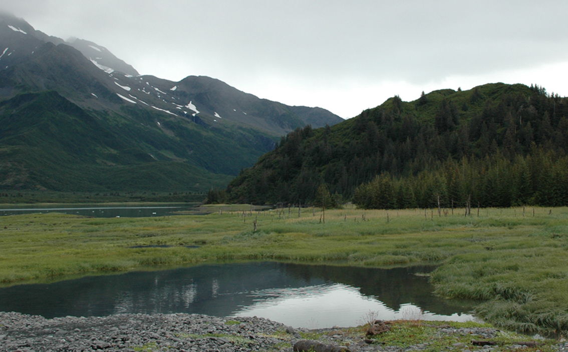
Two northwest looking photographs located on the northeast side of Wachusett Inlet, Saint Elias Mountains, Alaska. The September 9, 1961 photograph shows the lower reaches of Plateau Glacier, then a tidewater calving valley glacier with parts of its terminus being land based on either side of the fiord. The central part of the terminus is capped with séracs and rises about 35 meters (115 feet) above tidewater. The terminus has a large semi-circular embayment in its center. Including submarine ice, the total ice thickness here is greater than 200 meters (656 feet). Note the absence of any vegetation in the foreground, which is covered by a boulder till. To the upper right of center, a black, linear medial moraine can be seen on the surface of a tributary to Plateau Glacier that descends from Mount Wordie. Two people are located on the knob in the center of the photograph. (M.T. Millet photograph M-61-P51, courtesy of the Glacier Bay National Park and Preserve Archive). The September 14, 2003 repeat photograph documents changes that occurred during the ensuing 42 years. Plateau Glacier retreated out of the field of view and has all but melted away, after leaving a small remnant, Plateau Remnant, on the flanks of the Bruce Hills (northeast of the field of view). The tributary glacier that formerly supported the medial moraine has retreated more than 2.75 kilometers (1.71 miles), thinned by as much as 275 meters (902 feet), and left an area of debris-covered ice in the path of its retreat. The dense vegetation covering much of the foreground area that was previously only bare boulder till includes Alnus, Salix, Populus, and Picea. The vegetation was so dense that the two geologists, wearing orange float-coat, standing at the shoreline on the right side of the peninsula, were unable to reach the point of the headland occupied by the two individuals in the 1961 photograph. (National Park Service photograph by R.D. Karpilo). |
||
Kenai Fjords National Park |
||||
| Pedersen Glacier | ||||
 July 23, 1909 High Resolution image |
 August 13, 2004 High Resolution image |
A pair of southwest-looking photographs taken from about the same shoreline location of Pedersen Glacier, Aialik Bay, Kenai Fjords National Park, Alaska. The pair documents significant changes that have occurred during the 95 years between July 23, 1909 and August 13, 2004. The 1909 photograph by U.S. Grant shows the north side of the then retreating terminus of Pedersen Glacier, grounded on the beach above tidewater. Little, if any vegetation is present in the photograph (USGS Photo Library Photograph–Grant 131). The 2004 photograph documents the retreat of Pedersen Glacier from the field of view, a retreat of about 1.5 kilometers (0.93 miles). Diverse vegetation, featuring alder and spruce, has become established on the hill slopes and on the elevated ground of the former terminus. Beach vegetation is also becoming established. (USGS Photograph by Bruce F. Molnia). | ||
 Between the mid-1920s and the early 1940s High Resolution image |
 August 10, 2005 High Resolution image |
A pair of north looking photographs of Pedersen Glacier, Kenai Mountains, Aialik Bay, Alaska, both taken from the same location on the west shoreline of Aialik Bay. The first photograph is an undated summer view, probably dating from between the mid-1920s and the early 1940s. This photograph is from a postcard labeled Pederson Glacier, Aialik Bay, Alaska. The water in the foreground is part of an ice-marginal lake/lagoon located adjacent to Aialik Bay. When photographed, Pedersen Glacier was calving icebergs into the lake from a séracs-capped terminus that ranged from 20-40 m (66–131 feet) high. No vegetation is visible. (undated, unnumbered postcard; unknown photographer, courtesy of Kenai Fjords National Park). The second photograph dates from August 10, 2005. In the roughly 60 - 80 years between photographs, most of the lake/lagoon has filed with sediment and now supports several varieties of grasses, shrubs, and aquatic plants. Several dozen dead trees are remnants of a mid-20th century forest that was drowned by more than 3 meters (9.8 feet) of down warping of the coast during the 1964 Alaskan Earthquake. Pedersen Glacier’s terminus has retreated more than 2 kilometers (1.24 miles). The tributary located high above Pedersen Glacier separated from it sometime during the third quarter of the 20th century. No icebergs are visible. Isolated patches of snow are present at a few higher elevation locations. Note the stands of trees that have developed between the sediment filled wetland and the glacier. (USGS Photograph by Bruce F. Molnia). |
||
 1909 High Resolution image |
 2005 High Resolution image |
A pair of northwest looking photographs of Pedersen Glacier, Kenai Fjords National Park, Kenai Mountains, Aialik Bay, Alaska, both taken from the same location on the west shoreline of Aialik Bay. The first photograph by U.S. Grant, is a July 23, 1909 view of the then retreating northern part of the terminus. The water in the foreground is part of an ice-marginal lake/lagoon located adjacent to Aialik Bay. When photographed, Pedersen Glacier was calving icebergs into the lake from a sérac-capped terminus that was as much 40 meters (131 feet) high. Very little vegetation is visible. (USGS Photo Library Photograph – Grant 130). The second photograph dates from August 10, 2005. In the 94 years between photographs, most of the lake/lagoon has filed with sediment and now supports several varieties of grasses, shrubs, and aquatic plants. Several dozen dead trees are remnants of a mid-20th century forest that was drowned by more than 3 meters (9.8 feet) of down warping of the coast during the 1964 Alaskan Earthquake. Pedersen Glacier’s terminus is no longer in the field of view and has retreated more than 2 kilometers (1.2 miles) to the west. Only a few small icebergs are visible, the result of calving into a new lake that has formed as Pedersen Glacier has retreated. Note that vegetation has developed on nearly every exposed land surface. (USGS Photograph by Bruce F. Molnia). |
||
Yalik Glacier |
||||
 1909 High Resolution image |
 2004 High Resolution image |
A pair of north looking photographs of Yalik Glacier, Kenai Fjords National Park, Kenai Mountains, Nuka Passage, Alaska,, both taken from the same location in Nuka Passage, about 6 kilometers (3.7 miles) south of the position of the 1909 terminus of the glacier. The first photograph by D.F. Higgins, is an August 6, 1909 view of the then retreating northern part of the terminus. The absence of any icebergs indicates that by 1909, the glacier was no longer tidewater. When photographed, Yalik Glacier had a gently sloping terminus with little elevation at its margin. It is impossible to determine if vegetation was present. (USGS Photo Library Photograph – Grant 235). The second photograph dates from August 8, 2004. In the 95 years between photographs, Yalik Glacier has thinned by more than 100 meters (328 feet) and retreated more than 1.5 kilometers (0.93 miles). It is now fronted by an ice-marginal lake. The shoreline south of the glacier supports several varieties of grasses, shrubs, and trees. Note the vegetation on the mountain slopes. (USGS Photograph by Bruce F. Molnia). |
||
Aialik Glacier |
||||
 1909 High Resolution image |
 2005 High Resolution image |
A pair of northwest looking photographs of Aialik Glacier, Kenai Fjords National Park, Kenai Mountains, Aialik Bay, Alaska, both taken from the same location on the northwest shoreline of Squab Island. The first photograph by U.S. Grant, is a July 20, 1909 view of the then slowly retreating western part of the terminus. When photographed, Aialik Glacier was actively calving icebergs into the bay from a sérac-capped terminus that was as much as 40 meters (131 feet) high. No vegetation is visible. (USGS Photo Library Photograph –Grant 128). The second photograph dates from August 12, 2005. In the 96 years between photographs, the terminus of Aialik Glacier remains close to its 1909 position, retreating a maximum of 300 meters (984 feet) and thinning 20–50 meters (65.6-164 ft). Although only a few small icebergs are visible in the photograph, Aialik Glacier is still a major tidewater calving glacier. Note that vegetation has developed on nearly every exposed land surface. (USGS Photograph by Bruce F. Molnia). |
||
| McCarty Glacier | ||||
 July 30, 1909 High Resolution image |
 August 11, 2004 High Resolution image |
A pair of northeast-looking photographs taken from about 5 miles north of the mouth of McCarty Fjord, Kenai Fjords National Park, Alaska. The pair documents significant changes that have occurred during the 95 years between July 30, 1909 and August 11, 2004. The 1909 photograph by U.S. Grant shows the east side of the terminus of the then retreating McCarty Glacier, a tidewater glacier. Little, if any vegetation is present on the upper slopes, but beach grass is present in the foreground and trees are present on the back beach to the right (USGS Photo Library Photograph – Grant 143). The 2004 photograph shows part of McCarty Glacier, which has retreated more than 15 kilometers (9.3 miles) up the bay. Dense, diverse vegetation, featuring alder, willow, and spruce, has become established on the hill slopes and back beach areas. Note the beach grass in the foreground. (USGS Photograph by Bruce F. Molnia). | ||
 July 30, 1909 High Resolution image |
 August 11, 2004 High Resolution image |
A pair of northwest-looking photographs taken from about 8 kilometers (5 miles) north of the mouth of McCarty Fjord, Kenai Fjords National Park, Alaska. The pair documents significant changes that have occurred during the 95 years between July 30, 1909 and August 11, 2004. The 1909 photograph by USGS Geologist U.S. Grant shows the west side of the terminus of the then retreating McCarty Glacier, a tidewater glacier. Little, if any vegetation is present in the photograph (USGS Photo Library Photograph – Grant 144). The 2004 photograph documents the retreat of McCarty Glacier from the field of view, a retreat of more than 15 kilometers (9.8 miles). Dense, diverse vegetation, featuring spruce, has become established on the hill slopes. (USGS Photograph by Bruce F. Molnia). | ||
 July 30, 1909 High Resolution image |
 August 11, 2004 High Resolution image |
A pair of northwest-looking photographs, both taken from the same location in McCarty Fiord, Kenai Mountains, Alaska, shows changes to the McCarty Fiord area between 1909 and 2004. The July 30, 1909 photograph shows the west side of the terminus of the then retreating McCarty Glacier, It was taken from a location about 8 kilometers (5 miles) north of the mouth of McCarty Fiord. The area in the foreground is composed of a variety of types of glacial deposits including recessional moraines and outwash. The area is probably underlain by a thick mass of relict ice. Note the barren zone and adjacent Picea-dominated vegetation, located to the left of the summit ridge of glacier ice. A number of Alnus are growing in the foreground. (USGS photograph by D.F. Higgins). The August 11, 2004 photograph is taken from the same location, but more than years later. During the period between photographs, the terminus of McCarty Glacier has retreated about 15 kilometers (9.8 miles) to the north. The area in the foreground, formerly covered by a variety of types of glacial sedimentary deposits, is now open ocean water, the result of melting of the relict glacier ice underlying the sediment deposits. In places, the depth to the fiord floor exceeds 200 meters (656 feet). The former barren zone and adjacent hillside is now covered by dense vegetation, featuring mature Picea. Note the absence of any icebergs. (USGS Photograph by Bruce F. Molnia). |
||
| Holgate Glacier | ||||
 July 24, 1909 High Resolution image |
 August 13, 2004 High Resolution image |
A pair of northwest-looking photographs taken from near the head of Holgate Arm, Aialik Bay, Kenai Fjords National Park, Alaska. The pair documents significant changes that have occurred during the 95 years between July 24, 1909 and August 13, 2004. The 1909 photograph by USGS Geologist U.S. Grant shows Holgate Glacier, a tidewater glacier at the head of the fiord with “Little Holgate Glacier,” one of its former tributaries, located to its left. “Little Holgate Glacier terminates at the shoreline. No vegetation is present at the head of the fiord (USGS Photo Library Photograph–Grant 132). The 2004 photograph documents the continuing retreat of both glaciers. “Little Holgate Glacier’ has separated into several smaller ice masses and Holgate’s terminus, while still tidewater, has retreat from the field of view. Alder has become established on the hill slopes. (USGS Photograph by Bruce F. Molnia). | ||
| Bear Glacier | ||||
 September 2, 2002 High Resolution image  August 13, 2007 High Resolution image |
 August 6, 2005 High Resolution image |
Three oblique aerial photographs that show changes in the terminus of Bear Glacier, Kenai Mountains, Kenai Fjords National Park, Alaska, during the five year period between 2002 and 2007. The September 2, 2002 oblique aerial photograph of is taken towards the north and shows the retreating, calving terminus of the glacier, located at the head of a large ice-marginal lake, informally named Bear Lake. Prior to 1950, the entire basin of Bear Lake was filled by Bear Glacier’s piedmont lobe. By 1961, a small lake occupying less than 10% of the basin had developed adjacent to the southeast margin of the glacier. By 1984, the lake nearly doubled in size. In the 18 years between 1984 and September 2002, the lake quadrupled in size. The triangular-shaped terminus of the glacier depicted here has retreated at least 2 kilometers (1.2 miles) from its 1984 maximum position. The large tabular icebergs and the low relief, low-gradient terminus suggests that the terminus has thinned so much that much of its lower reaches are afloat. Floating glacier termini typically retreat rapidly and calve large tabular icebergs. (USGS photograph by Bruce F. Molnia). The second photograph was made on August 6, 2005. During the 35 months between photographs, the triangular-shaped terminus of the glacier retreating more than 3 kilometers (1.9 miles) with the large triangular lobe disappearing, the result of intensive passive calving. The glacier has also thinned by about 10 meters (33 feet). The large tabular icebergs that are present are evidence of the rapid disarticulation of the glacier’s terminus. (USGS photograph by Bruce. F. Molnia). The third photograph was made on August 13, 2007. From 2005-2007, the terminus continued to retreat through passive calving, although at a slower rate than prior to 20005. A few of the large tabular icebergs are remnants of even larger icebergs present in 2005. Others are the result of continuing disarticulation of the glacier’s western terminus. In the 24 months between images, the western margin of the glacier retreated more than 0.4 kilometers (0.25 miles). (USGS Photograph by Bruce F. Molnia). | ||
 Taken during the 1920s High Resolution image |
 August 12, 2005 High Resolution image |
A pair of northeast-looking photographs, both taken from the same location on a ridge in Bulldog Cove, near Bear Glacier Point, Kenai Mountains, Alaska, shows changes to Bear Glacier between the early 1920s and 2005. The older photograph is from a postcard labeled Harding Glaciers, Resurrection Bay, Alaska. The water in the foreground is part of lower Resurrection Bay. The name Harding Glacier or Glaciers was never officially adopted for Bear Glacier. In 1923, President Warren G. Harding visited Alaska, including a trip to Resurrection Bay and nearby Seward. The name Harding Icefield was officially approved in 1950 for the upland accumulation area that feeds Bear Glacier and a number of other glaciers of the Kenai Fiords. When photographed in the 1920s, Bear Glacier’s piedmont lobe was greatly expanded. Note that a few small shrubs or trees are present on the low sediment plain in front of the glacier’s terminus. (undated, unnumbered postcard; unknown photographer, courtesy of Kenai Fjords National Park). The second photograph was made on August 12, 2005. In the approximately 80 years between photographs, Bear Glacier’s piedmont lobe has retreated completely out of the field of view. Large icebergs, floating in the ice-marginal lake that fills the basin formerly occupied by Bear Glacier’s piedmont lobe, represent the only glacier ice that is visible. Isolated patches of snow are present at a few higher elevation locations. Note the dense vegetation that has developed around the margin of the lake and on most of the lower gradient slopes. (USGS Photograph by Bruce F. Molnia). |
||
 1909 High Resolution image |
 2005 High Resolution image |
A pair of northeast looking photographs taken from the same location on the cobble backbeach south of Bear Glacier, Kenai Fjords National Park, Kenai Mountains, Resurrection Bay, Alaska. The first photograph by U.S. Grant, is a July 20, 1909 photograph of the eastern part of the terminus of Bear Glacier, fronted by a small outwash plain and several moraine ridges. When photographed, the glacier was slowly retreating. (USGS Photo Library - Photograph Grant 123). ). The second photograph dates from August 11, 2005. In the 96 years between photographs, Bear Glacier has retreated more than 3 kilometers (1.9 miles) and is no longer in the field of view. It has thinned by as much as 200 meters (656 feet). The sediment body in the foreground is often overtopped by storm waves, hence the driftwood log. The water in the middle of the photograph is part of the river that connects the large ice-marginal lake that has developed adjacent to the retreating terminus with Resurrection Bay. Note the abundant vegetation north of the river. (USGS Photograph by Bruce F. Molnia). |
||
 1909 High Resolution image |
 2005 High Resolution image |
A pair of north looking photographs taken from the same location on the backbeach south of Bear Glacier, Kenai Fjords National Park, Kenai Mountains, Resurrection Bay, Alaska. The first photograph by U.S. Grant, is a July 20, 1909 photograph of the eastern part of the terminus of Bear Glacier, fronted by a small outwash plain and a small lagoon. When photographed, the glacier was slowly retreating. (USGS Photo Library - Photograph Grant 120). The second photograph dates from August 11, 2005. In the 96 years between photographs, Bear Glacier has retreated more than 3 kilometers (1.9 miles) and thinned by as much as 200 meters (656 feet). Only a very small part of Bear Glacier is visible. The tributary descending from the mountains was not visible in 1909 as it was hidden by the then massive terminus of the glacier. The lagoon present in 1909 has been filled with sediment and the outwash plain to the north is covered by grasses, wildflowers, shrubs, and trees. (USGS Photograph by Bruce F. Molnia). |
||
| Northwestern Glacier | ||||
 1909 High Resolution image |
 2004 High Resolution image |
A pair of northwest-looking photographs, both taken from the same location in Harris Bay, Kenai Fjords National Park, Kenai Mountains, Alaska, showing the changes that have occurred to Northwestern Glacier and its adjacent regions during the 95 year period from July 26, 1909 and August 11, 2004. The 1909 photograph by U.S. Grant shows the then retreating terminus of Northwestern Glacier, then extending to within 450 meters (1,476 feet) of its late-Little Ice Age maximum position. In places, the height of the terminus exceeded 50 meters (164 feet). No vegetation is visible in the photograph. (USGS Photo Library - Photograph Grant 136). By August 2004, Northwestern Glacier has retreated out of the field of view. In fact, the 2004 terminus is located more than 10 kilometers (6.2 miles) to the northwest. Ogive Glacier, a former tributary glacier to Northwestern Glacier, is the glacier visible to the left of center. Ice-free Harris Bay and Northwestern Lagoon make up the foreground of the image. (USGS Photograph by Bruce F. Molnia). |
||
 1909 High Resolution image |
 2005 High Resolution image |
A pair of northwest-looking photographs, both taken from the same location on a cobble beach on the west shoreline of Harris Bay, Kenai Fjords National Park, Kenai Mountains, Alaska, showing the changes that have occurred to Northwestern Glacier and its adjacent regions during the 95 year period from July 26, 1909 and August 11, 2004. The 1909 photograph by U.S. Grant shows the then retreating terminus of Northwestern Glacier, then extending to within within 450 meters (1,476 feet) of its late-Little Ice Age maximum position. In places, the height of the terminus exceeded 50 meters (164 feet). No vegetation is visible in the photograph. (USGS Photo Library - Photograph Grant 137). By August 2004, Northwestern Glacier has retreated out of the field of view. In fact, the 2004 terminus is located more than 10 kilometers (6.2 miles) to the northwest. Ice-free Harris Bay makes up the foreground of the image. (USGS Photograph by Bruce F. Molnia). |
||
 1920s-1940s High Resolution image |
 August 12, 2005 High Resolution image |
A pair of north looking photographs, both taken from the same location on the west shoreline of Harris Bay, Kenai Fjords National Park, Kenai Mountains, Alaska. The first photograph is an undated winter to early summer view, probably dating from between the mid-1920s and the 1940s. This photograph is from a postcard. The rocky shoreline in the foreground is covered by numerous pieces of brash ice, small icebergs, calved by the retreating Northwestern Glacier. When photographed, Northwestern Glacier had a sérac-capped terminus that ranged from 20-50 meter (65.6-164 feet) high. No vegetation is visible. (Undated, unnumbered postcard; unknown photographer, courtesy of Kenai Fjords National Park). The second photograph dates from August 12, 2005. In the roughly 60 - 80 years between photographs, Northwestern Glacier has retreated out of the field of view. In fact, the 2005 terminus is located more than 10 kilometers (6.2 miles) to the northwest. Ice-free Harris Bay makes up the foreground of the image. (USGS Photograph by Bruce F. Molnia). |
||
 1920s-1940s High Resolution image |
 August 12, 2005 High Resolution image |
A pair of northeast looking photographs, both taken from the same location on the west shoreline of Harris Bay, Kenai Fjords National Park, Kenai Mountains, Alaska. The first photograph is an undated winter to early spring view, probably dating from between the mid-1920s and the 1940s. The shallow water adjacent to the shoreline in the foreground appears to be covered by a small thickness of sea ice, containing a number of pieces of brash ice. Northwestern Glacier spans most of the width of the photograph. When photographed, the glacier was retreating and had a sérac-capped terminus that ranged from 20-50 meters (65.6-164 feet) high. Note the large trees. This location was being used for subsistence hunting by local Native Alaskans. (Undated, unnumbered photograph; unknown photographer, courtesy of Kenai Fjords National Park). The second photograph dates from August 12, 2005. In the roughly 60 - 80 years between photographs, Northwestern Glacier has retreated out of the field of view. Sedimentation and uplift have expanded the shore area and produced a marshy wetland covered by a diverse array of vegetation. (USGS Photograph by Bruce F. Molnia). |
||
Western Prince William Sound |
||||
| Harvard Glacier | ||||
 July 1, 1909 High Resolution image |
 September 3, 2000 High Resolution image |
A pair of north-looking photographs taken from near the head of Harvard Arm, College Fiord, Prince William Sound, Chugach National Forest, Alaska. The pair documents significant changes that have occurred during the 91 years between July 1, 1909 and September 3, 2000. The 1909 photograph by USGS Geologist U.S. Grant shows Harvard Glacier at the head of the fiord with Radcliffe Glacier, one of its largest tributaries, flowing into it at the right of center, Baltimore Glacier, a retreating hanging glacier is at the left side of the photo. Vegetation is not apparent. If any is present, it is on the hill slopes above the fiord (USGS Photo Library Photograph–Grant 208). The 2000 photograph documents the continuing advance of Harvard Glacier, which has completely obscured the view of Radcliff Glacier. Baltimore Glacier has continued to retreat and thin. Alder has become established on the hill slopes, but is difficult to see from the photo location. Harvard Glacier has advanced more than 1.25 kilometers (0.78 miles) since 1909. (USGS Photograph by Bruce F. Molnia). | ||
| Toboggan Glacier | ||||
 August 20, 1905 High Resolution image  August 22, 2008 High Resolution image |
 September 4, 2000 High Resolution image |
Three north-looking photographs, all taken from about the same offshore location, about 0.5 kilometers (0.3 miles) north of Toboggan Glacier, Harriman Fiord, Prince William Sound, Chugach National Forest, Alaska. The three photographs document significant changes that have occurred during the 103 years between August 20, 1905 and August 22, 2008. An intermediate age photograph shows the glacier on September 4, 2000. The 1905 photograph shows that Toboggan Glacier was thinning and retreating and was surrounded by a large bedrock barren zone. This suggests that retreat and thinning began in the mid- to late-19th century. Minimal vegetation existed on the fiord-facing hill slopes. In 1905, the terminus appears to have thinned to about 50% of its former thickness. Note the gently dipping sediment plain adjacent to the terminus. Note the two arcuate ridges, capped by several hummocky mounds that are located on the surface of the outwash sediments. The ridges are recessional moraines, dating from the late 19th century. (USGS Photo by Sidney Paige - 731). The 2000 photograph documents that after 95 years, the glacier is still thinning and retreating. Its terminus, a thin tongue of ice, can be seen surrounded by a mass of debris. The glacier has thinned as much as 150 meters (492 feet) and retreated more than 0.5 kilometers (0.3 miles). A large accumulation of snow sits on the valley floor adjacent to where the northern-most hanging glacier tributary previously joined Toboggan Glacier. The tributary no longer makes contact, having retreated more than 0.6 kilometers (0.37 miles) up the valley wall. The former zone of barren bedrock is now covered by vegetation. (USGS photograph by Bruce. F. Molnia). The August 22, 2008 photograph documents the continuing thinning and retreat of Toboggan Glacier. The thin tongue of terminus ice that was visible 8 years earlier is gone. Both hanging glacier tributaries continue to retreat. (USGS photograph by Bruce F. Molnia). | ||
| Yale Glacier | ||||
 June 1937 High Resolution image |
 July 28, 2006 High Resolution image |
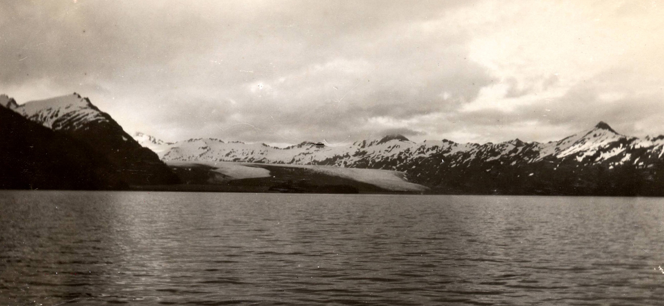
This pair of oblique aerial photographs of Yale Glacier, Chugach Mountains, Chugach National Forest, Alaska, documents changes that occurred during the 69 years between June 1937 and July 28, 2006. Both photographs are taken towards the north and show the retreating, calving, tidewater terminus of Yale Glacier, located at the head of Yale Arm, College Fiord, Prince William Sound, Alaska. In 1937, Yale Glacier’s terminus was located at about the same position that it occupied when it was visited by the Harriman Alaska Expedition in 1899. A stream of icebergs issues from several embayments cut into the approximately 45 meter (148 feet) high face on the east side of the terminus. Several current and former tributary valley glaciers descend the east wall of the fiord. The two closest to the terminus have lost contact with Yale Glacier. Except for the moraine-covered ice on both margins of the glacier, snow still covers most of the lower reaches of the glacier. (B. Washburn, #122, courtesy of National Snow and Ice Data Center). During the intervening 69 years between photographs, Yale Glacier has retreated as much as 6 kilometers (3.7 miles), with most of the retreat occurring post-1957. The width of the tidewater part of the terminus of the glacier is much less than half of what it was in 1937. Yale Glacier has thinned substantially, in places by more than 250 meters (820 feet). All of the eastern tributaries have retreated and lost contact with Yale Glacier. An island and a large area of glacially sculpted bedrock have emerged from beneath the retreating glacier. Retreat of the land-based western portion of the terminus has kept pace with the retreat of the eastern tidewater portion of the glacier. A well-developed trimline is visible on the west side of the glacier. The 2006 photograph was made from an altitude of approximately 3,200 meters (10,500 feet), while Washburn’s, 1937 photograph was made from an altitude of more than 5,200 meters (17,050 feet). (USGS Photograph by Bruce F. Molnia). | ||
Denali National Park |
||||
| Unnamed Glacier | ||||
 June 1919 High Resolution image |
 August 2004 High Resolution image |
A pair of north-looking photographs, both taken from the same location near the retreating unnamed valley glacier that forms the East Fork of the Teklanika River, Denali National Park and Preserve, Alaska. The pair documents changes that have occurred during the 85 years between June 1919 and August 2004. The 1919 photograph by USGS Geologist Stephen Capps shows the then retreating, debris-covered terminus of “East Fork Teklanika Glacier” with an elevated lateral moraine on its west (left) side. Small tundra plants are the only identifiable vegetation (USGS Photo Library Photograph – Capps). The 2004 photograph documents the continued thinning and retreat of “East Fork Teklanika Glacier.” The glacier has retreated more than 0.3 kilometers (0.19 miles) since 1919, retreating at an average rate of about 4.0 meters per year (13 feet per year). (2004 NPS Photograph by Ron Karpilo). | ||
| Northern Rocky Mountain Science Center (NOROCK) - Repeat Photography Project | ||||
Glacier Home Page ||
Weather and Climate ||
Water on Earth ||
Introduction to Glaciers ||
Monitoring Earth's Glaciers ||
Glaciers and Sea Level ||
Glaciers of Alaska ||
Repeat Photography ||
Frozen in Time? ||
Additional Information

![]() U.S. Department of the Interior |
U.S. Geological Survey
U.S. Department of the Interior |
U.S. Geological Survey
URL: http://www.usgs.gov/global_change/glaciers/repeat_photography.asp
Page Contact Information: Ask USGS
Page Last Modified: Thursday, December 18, 2008
