| Projects & Studies
|
| »
|
Flood Risk Management Continuing Authority, Red River of the North: Wahpeton, N.D.
|
| »
|
Integrated Watershed Study: Minnesota River Basin in Minnesota, South Dakota, North Dakota and Iowa
|
| »
|
Lower St. Anthony Falls Rapids Restoration, Mississippi River, Minneapolis, Minn.
|
| »
|
Mississippi Headwaters Reservoirs Project Sites
|
| »
|
Mississippi Place, Mississippi River, St. Paul, Minn.
|
| »
|
Mississippi River Recreation and Environmental Stewardship, Eau Galle Dam
|
| »
|
Reconnaissance Study: Minnesota River Basin in MN, SD, IA and ND
|
| »
|
Recreational Boating Study of the Mississippi River, Pools 4 to 9, Summer 2003
|
| »
|
River Resource Values and Expectation
|
| »
|
Western Flood Control Sites - Minnesota: Lake Traverse, Orwell Lake, Hwy 75 - Bigstone, Lac qui Parle
|
| »
|
Western Flood Control Sites – North Dakota: Lake Ashtabula, Homme Lake Souris River
|
|
|
|
Winnibigoshish Lake and Dam
*** Lake Winnibigoshish Recreation Area is offering full services. ***
|
|
Overview
|
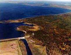
The Lake Winnibigoshish Recreation Area is situated at the outlet of Lake Winnibigoshish, located about 14 miles northwest of Deer River, Minn. The lake is 67,000 acres in size and has 141 miles of shoreline. It was formed by a huge ice block left behind by a receding glacier.
Area forests contain towering red pine, which are home to an abundant assortment of animals including bald eagles, porcupines, black bears, chipmunks and many others. Seasonal berries that decorate the forest floor include blackberries, raspberries and blueberries. Spectacular sunsets can be viewed from the dam structure as you look west out over the reservoir.
|
The well maintained, clean recreation area offers camping, boating, picnicking, fishing and playground areas. The camp sites are located east of the Mississippi River and Winnibigoshish Dam. A majority of the camp sites are available for reservation. Some have access to electricity. There is also a camp site and rest room accessible to those who are mobility impaired.
Lake Winnibigoshish is one of the premier walleye, perch and musky lakes in the state. Fishing is allowed from the shoreline, as well as from boats. There is one boat ramp that leads into the Mississippi River for a cool and relaxing day.
|
|
Directions
|
From Deer River, Minn., go west on U.S. Hwy. 2 for one mile, turn right on MN Hwy. 46 and go 12 miles, turn left on Itasca County 9 and go 2 miles, turn left at signs.
|
|
Recreation Information
|

Make a reservation with the National Recreation Reservation Service
Detailed information on individual campsites, picnic shelters, availability, cost, etc.
|
 You can reserve camp sites and day use facilities at many U.S. Army Corps of Engineers recreation areas nation-wide, as well as many other agencies, online by visiting RECREATION.GOV. Reservations may also be made by calling RECREATION.GOV toll free at 1-877-444-6777.
|
|
History
|
The Winnibigoshish Lake Dam is located on the Mississippi River at the outlet of Lake Winnibigoshish. This is the largest reservoir in the system; it controls the runoff from a 1,442-square-mile drainage area containing 28 lakes.
The Corps of Engineers began construction of the original timber dam at "Winni" in 1881. It was put into operation in 1884. Nearly 2 million feet of white and Norway pine cut from the lakeshore were employed in construction of the pilings, dams and other structures. Logging operations, labor and material shortages, weather problems and the difficulties of constructing roads and installing machinery in near-wilderness conditions caused construction delays. The project employed 300 skilled and unskilled laborers, including local Chippewa Indians. In 1882, the Corps of Engineers announced that, "The Winnibigoshish Dam is the inauguration of the reservoir system for the entire country."
|
The present concrete structure was constructed between 1899 and 1900. Stop logs divide five 13-foot sluiceways into three sections. A 12-foot log sluice and a five-foot fishway, the latter constructed in 1912, are no longer in use.
During the first phase of dam construction, workmen built 17 buildings across the channel to the west, opposite the present site. All of the buildings were of log construction. A map of 1883, made by Capt. Thomas Allen, shows the Corps' headquarters and the nearby location of an Indian village and burial mounds. At the time of dam reconstruction between 1899 and 1900, the complex of buildings was also reconstructed at the opposite side of the dam.
|
Of special note is a prominent prehistoric linear burial mound located east of the present Corps of Engineers' maintenance building. Also, the Lake Winnibigoshish Dam was listed on the National Register of Historical Places in 1982.
|
|
|
[Printable Copy]
|