| Projects & Studies
|
| »
|
Ambrough Slough Habitat Project, Pool 10, Wisconsin
|
| »
|
Aquatic Ecosystem Restoration: Section 206, Paint Creek Restoration, Waukon, Iowa
|
| »
|
Asian Carp Barrier System Upper Mississippi River
|
| »
|
Blackhawk Park Backwater Restoration Project , Victory, Wisconsin
|
| »
|
Bussey Lake Habitat Project, Guttenberg, Iowa
|
| »
|
Capoli Slough Habitat Project, Pool 9, Wisconsin
|
| »
|
Christine and Hickson Dams
|
| »
|
Cold Springs Habitat Project, Crawford County, Wis.
|
| »
|
Conway Lake Habitat Project, Lansing, Iowa
|
| »
|
Drayton Dam Habitat Restoration, Drayton, North Dakota
|
| »
|
Dresbach Island Revegetation Project
|
| »
|
East Channel Habitat Project, La Crescent, Minn./Wis.
|
| »
|
Endangered Species - Conservation of Native Mussels
|
| »
|
Environmental Infrastructure Assistance - City of Garrison and Kathio Township, Minnesota
|
| »
|
Environmental Infrastructure Assistance Program: Section 219 - Devils Lake and All of North Dakota
|
| »
|
Environmental Infrastructure Assistance Program: Section 219 at Central Lakes, Goodview, Grand Rapids, Willmar, Minnesota
|
| »
|
Environmental Infrastructure Assistance Program: St. Croix Falls, Wisconsin
|
| »
|
Fargo-Moorhead and Upstream Feasibility Study
|
| »
|
Feasibility Study: Blue Earth River Basin in Minnesota and Iowa
|
| »
|
Finger Lakes Habitat Project , Wabasha, Minnesota
|
| »
|
General Investigations: Hydropower, Crown Hydro, Minneapolis, Minnesota
|
| »
|
General Investigations: Hydropower, Ford Plant, Minneapolis, Minnesota
|
| »
|
Grand Marais River Aquatic Ecosystem Restoration
|
| »
|
Guttenberg Waterfowl Ponds Habitat Project, Iowa
|
| »
|
Habitat Restoration: Mississippi River, Pool 8 Islands Phase III, Wisconsin/Minnesota
|
| »
|
Habitat Restoration: Mississippi River, Clear (Finger) Lake, Pool 5, Minnesota
|
| »
|
Harpers Slough Habitat Project, Pool 9, Iowa
|
| »
|
Hay Creek Aquatic Ecosystem Restoration - Roseau County, Minnesota
|
| »
|
Indian Slough Habitat Project, Buffalo County, Wis.
|
| »
|
Integrated Watershed Study: Minnesota River Basin in Minnesota, South Dakota, North Dakota and Iowa
|
| »
|
Island 116 Channel Closure & Shoreline Stabilization
|
| »
|
Island 42 Habitat Project, Wabasha County, Minn.
|
| »
|
Kinnickinnic River Aquatic Ecosystem Restoration
|
| »
|
Lake Onalaska Habitat Project, La Crosse, Wisconsin
|
| »
|
Lake Winneshiek Habitat Project, Ferryville, Wis.
|
| »
|
Lansing Big Lake Habitat Project, Lansing, Iowa
|
| »
|
Long Lake Habitat Project , Trempealeau, Wisconsin
|
| »
|
Long Meadow Lake Habitat Project, Bloomington, Minn.
|
| »
|
Lower St. Anthony Falls Rapids Restoration, Mississippi River, Minneapolis, Minn.
|
| »
|
Marsh Lake Ecosystem Restoration Feasibility Study, Lac Qui Parle Wildlife Area, MN
|
| »
|
McGregor Lake Habitat Project, Prairie du Chien, Wisconsin
|
| »
|
Minnehaha Creek Watershed Study
|
| »
|
Mississippi River Bank Stabilization Habitat Project, Minn/Wis/Iowa
|
| »
|
Mississippi River Locks and Dams Nos. 2-10 Embankment Rehabilitation
|
| »
|
Mississippi River Recreation and Environmental Stewardship, Eau Galle Dam
|
| »
|
Mississippi River: Lock & Dam 3 Navigation Safety and Embankments, Minnesota and Wisconsin
|
| »
|
Mud Lake Water Management
|
| »
|
North Ottawa Impoundment Project, Grant County, Minn.
|
| »
|
Orr, Minnesota Water Line Replacement - Section 569 Environmental Infrastructure Program
|
| »
|
Painter Creek Habitat Restoration, Minnehaha Creek, Minnesota
|
| »
|
Peterson Lake Habitat Project, Wabasha, Minnesota
|
| »
|
Pigs Eye Habitat Restoration Lake, St. Paul, Minnesota
|
| »
|
Polander Lake Habitat Project, Winona, Minnesota
|
| »
|
Pool 8 Islands Phase I Habitat Project, Wisconsin
|
| »
|
Pool 8 Islands Phase II Habitat Project, Stoddard, Wis.
|
| »
|
Pool 9 Island Habitat Project, Wisconsin
|
| »
|
Pool Slough Habitat Project, New Albin, Iowa
|
| »
|
Reconnaissance Report: Baraboo/Wisconsin River
|
| »
|
Reconnaissance Study: Minnesota River Basin in MN, SD, IA and ND
|
| »
|
Recreational Boating Study of the Mississippi River, Pools 4 to 9, Summer 2003
|
| »
|
Red Lake River/Zah Gheeng Marsh Projects, Clearwater County, Minn.
|
| »
|
Red River of the North Basin: Basin-Wide Watershed Management Planning
|
| »
|
Red River of the North Basin: Minnesota, North Dakota, South Dakota and Manitoba, Reconnaissance Study
|
| »
|
Rice Lake Habitat Project, Savage, Minnesota
|
| »
|
River Resource Values and Expectation
|
| »
|
Ruffy Brook Aquatic Ecosystem Restoration, Clearwater County, Minnesota
|
| »
|
Sand Hill River Aquatic Ecosystem Restoration, Minn.
|
| »
|
Small Scale Drawdown Habitat Project, Buffalo City, Wis.
|
| »
|
South Washington Watershed District
|
| »
|
Spring Lake Islands Habitat Project, Buffalo City, Wis.
|
| »
|
Spring Lake Peninsula Habitat Project, Buffalo City, Wis.
|
| »
|
St. Croix Headwaters Watershed Study, Wisconsin
|
| »
|
St. Croix River: Endangered Mussel Conservation - Zebra Mussel Control
|
| »
|
St. Croix Watershed Reconnaissance Study
|
| »
|
Streambank Protection: Section 14 Minnehaha Creek WPA Walls, Minnesota
|
| »
|
Streambank Protection: Section 14, Barnes County, Kathryn, North Dakota
|
| »
|
Streambank Protection: Section 14, Pug Hole Lake, Minnesota
|
| »
|
Streambank Protection: Section 14, Sartell, Minnesota
|
| »
|
Sturgeon Lake, Pine County, Minnesota, Wastewater Collection and Treatement Facility
|
| »
|
Sunrise River Watershed Study, Minnesota
|
| »
|
Trempealeau National Wildlife Refuge, Trempealeau, Wis
|
| »
|
Upper Mississippi River - Illinois Waterway System Navigation Study
|
| »
|
Upper St. Croix Lake Sanitary District Wastewater Collection Systems Improvement Project
|
| »
|
WKTY-AM Study Area
|
| »
|
Western Flood Control Sites - Minnesota: Lake Traverse, Orwell Lake, Hwy 75 - Bigstone, Lac qui Parle
|
| »
|
Western Flood Control Sites – North Dakota: Lake Ashtabula, Homme Lake Souris River
|
| »
|
Wild Rice River (MN) Feasibility Study
|
| »
|
Wild Rice River Aquatic Ecosystem Restoration, Minn.
|
| »
|
Zebra Mussels and Management Implications for Endangered Freshwater Mussels on the Upper Mississippi River System
|
|
|
|
Mud Lake Water Management
Mud Lake is part of the U.S. Army Corps of Engineers, St. Paul District, Lake Traverse flood control project (see link at right). It is located at the headwaters of the Red River of the North on the Minnesota-South Dakota border near Wheaton, Minn. Mud Lake has long been an important breeding and migration staging area for waterfowl, but land use changes in its watershed, and reservoir water level management have reduced its value as waterfowl habitat. Specifically, water level stabilization has resulted in a lack of submersed and emergent aquatic vegetation and its associated invertebrate communities.
|
In 1983, the Mud Lake Management Group was formed to coordinate management activities at the lake. This group was comprised of representatives from the Corps' St. Paul District, the U.S. Fish and Wildlife Service, the South Dakota Game and Fish Department, the Minnesota Department of Natural Resources, Ducks Unlimited, lakeshore landowners and local sportsmen's groups.
|
The working group focused on water level manipulation, specifically drawdowns, as a means of improving the waterfowl habitat of Mud Lake. Deliberate drawdown is a widely used technique for managing waterfowl impoundments that exposes sediments, thereby encouraging the release of nutrients and the reestablishment of wetland plants. The group also began a vegetation monitoring effort to provide data to guide management activities. The first vegetation survey, completed in 1984, showed a large open-water area in relation to the area of emergent and submersed vegetation (see figure).
|
|
Following recommendations by the the working group, a drawdown of Mud Lake was conducted in 1988. This drawdown produced an excellent vegetative response. A 1992 survey showed that a large area of previously open water was converted to emergent and submersed vegetation. However, by 1994, the vegetation had again reverted back to a condition similar to that in 1984. A vegetation survey conducted in 2000 showed even further decline. The vegetation data provides evidence (see table) to indicate that another drawdown is needed and that a good vegetation response could result from it.
|
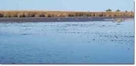
The following photographs show shallow open water areas in Mud Lake in 2000 that should support emergent and submerged aquatic vegetation.
|
|
In 2000, the working group developed a new management plan that included a two-year drawdown of the lake. During a drawdown, the water level of the lake would be held at least four feet lower than the normal level. Following this, the water level would be increased by two feet the first year and returned to normal the second year after drawdown. The plan was written in an adaptive format so that it could be changed as the need arises; thereby allowing the group to address other management problems and opportunities.
|
A drawdown was originally scheduled to begin in the spring of 2001. However, because of high water that year it was postponed until the spring of 2002. In March of 2002, the drawdown was started with the intention of continuing it through the fall of 2003, following the guidelines in the management plan.
|
The drawdown went fairly well in 2002. However, high water in late summer resulted in less than ideal conditions. Prior to the high water, the drawdown had produced a good vegetative response on the exposed mud flats. The Corps took photographs at selected locations to document the plant response (see link at right).
The drawdown continued into 2003 and appeared to be going well until the end of June, when high levels of precipitation and concerns from a Cargill plant downstream lead to halting the drawdown for the remainder of the year (see link to news release). Following this, the Mud Lake Management Group planned to continue the drawdown in 2004. The 2004 drawdown began in March and continued through the September. Water levels were increased for the fall hunting season. Mud Lake has again been drawn down for the summer of 2005. Water levels may be raised again for the fall hunting season if conditions allow.
|
Once water levels are returned to normal, the Corps will continue to monitor the vegetation at Mud Lake. This information will aid the working group in making decisions regarding management activities at the lake. Because wetland vegetation will naturally decline with stable water levels, drawdowns will be an important tool for the future management of Mud Lake.
|
|
|
[Printable Copy]
|