Didemnum sp. - Georges Bank Images

| August 25, 2006 |
Click here for video of Didemnum sp. colonies in Georges Bank. |
Video imagery VB_GB7_GBvideo1. Didemnum sp. colonies growing on gravel habitat; various colors represent different colonies growing against each other. Georges Bank (41 deg 55.12 m N lat, 67 deg 18.61 min W lon). Water depth 48m. August 25, 2006. Video credit: Page Valentine and Dann Blackwood (USGS). Video duration 2 min. Location no. 70.
Click here to download video. |
| November 1, 2003 |

Image VB_GB1_36660070 |
Image VB_GB1_36660070. Tunicate colonies of Didemnum sp. completely covering pebble gravel habitat. Small burrowing anemones surrounded and overgrown by tunicates. Two clam siphons surrounded by tunicate are visible in lower right center of image. Image height is 19 inches (48 cm). Station 311020 (41 deg 57.148 min N lat, 67 deg 30.891 min W lon). Northern Georges Bank. Water depth 47 m (154 ft). November 1, 2003. Collectors: Page Valentine, Jeremy Collie, Robert Reid. Photo credit: Page Valentine and Dann Blackwood, U.S. Geological Survey. Location no. 2.
Click here to download image. |
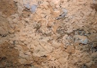
Image VB_GB1_36660079 |
Image VB_GB1_36660079. Tunicate colonies of Didemnum sp. almost completely covering pebble gravel habitat. Tunicate is growing over colonies of sea pork (Aplidium sp.; upper left), hydroids (upper right center), and polychaete worm (Filograna implexa; upper center and right center). Image height is 20 inches (51 cm). Station 311020 (41 deg 57.148 min N lat, 67 deg 30.891 min W lon). Northern Georges Bank. Water depth 47 m (154 ft). November 1, 2003. Collectors: Page Valentine, Jeremy Collie, Robert Reid. Photo credit: Page Valentine and Dann Blackwood, U.S. Geological Survey. Location no. 2.
Click here to download image. |
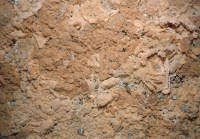
Image VB_GB1_36660080 |
Image VB_GB1_36660080. Tunicate colonies of Didemnum sp. completely covering pebble gravel habitat. Two clam siphons surrounded by tunicate are visible in center of image. Image height is 20 inches (51 cm). Station 311020 (41 deg 57.148 min N lat, 67 deg 30.891 min W lon). Northern Georges Bank. Water depth 47 m (154 ft). November 1, 2003. Collectors: Page Valentine, Jeremy Collie, Robert Reid. Photo credit: Page Valentine and Dann Blackwood, U.S. Geological Survey. Location no. 2.
Click here to download image. |

Image VB_GB1_36660086 |
Image VB_GB1_36660086. Tunicate colonies of Didemnum sp. completely covering pebble gravel habitat. Image height is 20 inches (51 cm). Station 311020 (41 deg 57.148 min N lat, 67 deg 30.891 min W lon). Northern Georges Bank. Water depth 47 m (154 ft). November 1, 2003. Collectors: Page Valentine, Jeremy Collie, Robert Reid. Photo credit: Page Valentine and Dann Blackwood, U.S. Geological Survey. Location no. 2.
Click here to download image.
|

Image VB_GB1_36660087 |
Image VB_GB1_36660087. Tunicate colonies of Didemnum sp. encrusting a boulder on pebble gravel habitat. Sea scallop approximately 5 inches (13 cm) in diameter unaffected by tunicates. One clam siphon is surrounded by tunicate visible to right of sea scallop. Station 311020 (41 deg 57.148 min N lat, 67 deg 30.891 min W lon). Northern Georges Bank. Water depth 47 m (154 ft). November 1, 2003. Collectors: Page Valentine, Jeremy Collie, Robert Reid. Photo credit: Page Valentine and Dann Blackwood, U.S. Geological Survey. Location no. 2.
Click here to download image.
|

Image VB_GB1_36660089 |
Image VB_GB1_36660089. Tunicate colonies of Didemnum sp. encrusting pebble gravel habitat and a sea scallop 5 inches (13 cm) in diameter. Station 311020 (41 deg 57.148 min N lat, 67 deg 30.891 min W lon). Northern Georges Bank. Water depth 47 m (154 ft). November 1, 2003. Collectors: Page Valentine, Jeremy Collie, Robert Reid. Photo credit: Page Valentine and Dann Blackwood, U.S. Geological Survey. Location no. 2.
Click here to download image. |

Image VB_GB1_36670001 |
Image VB_GB1_36670001. Tunicate colonies of Didemnum sp. encrusting pebble gravel habitat. Sea scallop approximately 5 inches (13 cm) in diameter) with hydroid colony overgrown by tunicate. Two clam siphons visible to right of center of the image. Station 311020 (41 deg 57.148 min N lat, 67 deg 30.891 min W lon). Northern Georges Bank. Water depth 47 m (154 ft). November 1, 2003. Collectors: Page Valentine, Jeremy Collie, Robert Reid. Photo credit: Page Valentine and Dann Blackwood, U.S. Geological Survey. Location no. 2.
Click here to download image.
|

Image VB_GB1_36670005 |
Image VB_GB1_36670005. Tunicate colonies of Didemnum sp. encrusting pebble gravel habitat. Young haddock 5 inches (13 cm) long. Station 311020 (41 deg 57.148 min N lat, 67 deg 30.891 min W lon). Northern Georges Bank. Water depth 47 m (154 ft). November 1, 2003. Collectors: Page Valentine, Jeremy Collie, Robert Reid. Photo credit: Page Valentine and Dann Blackwood, U.S. Geological Survey. Location no. 2.
Click here to download image.
|

Image VB_GB1_36670012 |
Image VB_GB1_36670012. Small, expanding tunicate colony of Didemnum sp. lying near the margin of a larger colony on exposed sand in pebble gravel habitat. Image height is 18 inches (46 cm). Station 311021 (41 deg 58.474 min N lat, 67 deg 30.969 min W lon). Northern Georges Bank. Water depth 41 m (135 ft). November 1, 2003. Collectors: Page Valentine, Jeremy Collie, Robert Reid. Photo credit: Page Valentine and Dann Blackwood, U.S. Geological Survey. Location no. 3.
Click here to download image. |

Image VB_GB1_36670020 |
Image VB_GB1_36670020. Tunicate colonies of Didemnum sp. encrusting pebble gravel habitat. Pebbles can be observed through the single thin layer of tunicates in the lower right hand part of the photo. Image height is 14 inches (36 cm). Station 311021 (41 deg 58.474 min N lat, 67 deg 30.969 min W lon). Northern Georges Bank. Water depth 41 m (135 ft). November 1, 2003. Collectors: Page Valentine, Jeremy Collie, Robert Reid. Photo credit: Page Valentine and Dann Blackwood, U.S. Geological Survey. Location no. 3.
Click here to download image. |

Image VB_GB1_36670028 |
Image VB_GB1_36670028. Tunicate colonies of Didemnum sp. completely covering pebble gravel habitat and overgrowing hydroid colonies. Image height is 17 inches (43 cm). Station 311021 (41 deg 58.474 min N lat, 67 deg 30.969 min W lon). Northern Georges Bank. Water depth 41 m (135 ft). November 1, 2003. Collectors: Page Valentine, Jeremy Collie, Robert Reid. Photo credit: Page Valentine and Dann Blackwood, U.S. Geological Survey. Location no. 3.
Click here to download image. |
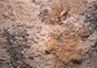
Image VB_GB1_36670042 |
Image VB_GB1_36670042. Tunicate colonies of Didemnum sp. encrusting pebble gravel habitat and overgrowing hydroid colonies (center and upper center of image) and a dark yellow sponge colony (lower center of image). Image height is 18 inches (46 cm). Station 311021 (41 deg 58.474 min N lat, 67 deg 30.969 min W lon). Northern Georges Bank. Water depth 41 m (135 ft). November 1, 2003. Collectors: Page Valentine, Jeremy Collie, Robert Reid. Photo credit: Page Valentine and Dann Blackwood, U.S. Geological Survey. Location no. 3.
Click here to download image. |

Image VB_GB1_36670043 |
Image VB_GB1_36670043. Tunicate colonies of Didemnum sp. advancing from left to right over pebble gravel habitat. Image height is 20 inches (51 cm). Station 311021 (41 deg 58.474 min N lat, 67 deg 30.969 min W lon). Northern Georges Bank. Water depth 41 m (135 ft). November 1, 2003. Collectors: Page Valentine, Jeremy Collie, Robert Reid. Photo credit: Page Valentine and Dann Blackwood, U.S. Geological Survey. Location no. 3.
Click here to download image. |

Image VB_GB1_36670050 |
Image VB_GB1_36670050. Very small, expanding tunicate colonies of Didemnum sp. on exposed sand in pebble gravel habitat with hydroid colonies. Image height is 19 inches (48 cm). Station 311022 (41 deg 58.179 min N lat, 67 deg 31.848 min W lon). Northern Georges Bank. Water depth 43 m (141 ft). November 1, 2003. Collectors: Page Valentine, Jeremy Collie, Robert Reid. Photo credit: Page Valentine and Dann Blackwood, U.S. Geological Survey. Location no. 4.
Click here to download image. |

Image VB_GB1_36670052 |
Image VB_GB1_36670052. Small, expanding tunicate colonies of Didemnum sp. on exposed sand in pebble gravel habitat with hydroid colonies. Image height is 19 inches (48 cm). Station 311022 (41 deg 58.179 min N lat, 67 deg 31.848 min W lon). Northern Georges Bank. Water depth 43 m (141 ft). November 1, 2003. Collectors: Page Valentine, Jeremy Collie, Robert Reid. Photo credit: Page Valentine and Dann Blackwood, U.S. Geological Survey. Location no. 4.
Click here to download image. |

Image VB_GB1_36670054 |
Image VB_GB1_36670054. Small, expanding tunicate colonies of Didemnum sp. on exposed sand in pebble gravel habitat with hydroid colonies. Image height is 19 inches (48 cm). Station 311022 (41 deg 58.179 min N lat, 67 deg 31.848 min W lon). Northern Georges Bank. Water depth 43 m (141 ft). November 1, 2003. Collectors: Page Valentine, Jeremy Collie, Robert Reid. Photo credit: Page Valentine and Dann Blackwood, U.S. Geological Survey.Location no. 4.
Click here to download image. |

Image VB_GB1_36670060 |
Image VB_GB1_36670060. Very small tunicate colonies of Didemnum sp. invading a gravel habitat. Tunicate colonies is center and in upper right of image. Young haddock is approximately 8 inches (20 cm) long. Station 311022 (41 deg 58.179 min N lat, 67 deg 31.848 min W lon). Northern Georges Bank. Water depth 43 m (141 ft). November 1, 2003. Collectors: Page Valentine, Jeremy Collie, Robert Reid. Photo credit: Page Valentine and Dann Blackwood, U.S. Geological Survey. Location no. 4.
Click here to download image. |

Image VB_GB1_36670063 |
Image VB_GB1_36670063. Small, expanding tunicate colonies of Didemnum sp. on pebble gravel habitat with hydroid colonies. Tunicate colony in center of image is on small patch of sand. Image height is 26 inches (66 cm). Station 311022 (41 deg 58.179 min N lat, 67 deg 31.848 min W lon). Northern Georges Bank. Water depth 43 m (141 ft). November 1, 2003. Collectors: Page Valentine, Jeremy Collie, Robert Reid. Photo credit: Page Valentine and Dann Blackwood, U.S. Geological Survey. Location no. 4.
Click here to download image. |

Image VB_GB1_36670066 |
Image VB_GB1_36670066. Very small tunicate colonies of Didemnum sp. colonizing many pebbles. Hydroid colonies on pebble gravel habitat. Sea scallop is approximately 4 inches (10 cm) in diameter. Station 311022 (41 deg 58.179 min N lat, 67 deg 31.848 min W lon). Northern Georges Bank. Water depth 43 m (141 ft). November 1, 2003. Collectors: Page Valentine, Jeremy Collie, Robert Reid. Photo credit: Page Valentine and Dann Blackwood, U.S. Geological Survey. Location no. 4.
Click here to download image. |

Image VB_GB1_36670069 |
Image VB_GB1_36670069. Small, expanding tunicate colonies of Didemnum sp. on pebble gravel habitat. Dark yellow sponge colony in left center of image. Image height is 20 inches (51 cm). Station 311022 (41 deg 58.179 min N lat, 67 deg 31.848 min W lon). Northern Georges Bank. Water depth 43 m (141 ft). November 1, 2003. Collectors: Page Valentine, Jeremy Collie, Robert Reid. Photo credit: Page Valentine and Dann Blackwood, U.S. Geological Survey. Location no. 4.
Click here to download image. |

Image VB_GB1_36670092 |
Image VB_GB1_36670092. Tunicate colonies of Didemnum sp. completely covering pebble gravel habitat. Encrusted mussel shell in right center of image. Image height is 18 inches (46 cm). Station 311022 (41 deg 58.179 min N lat, 67 deg 31.848 min W lon). Northern Georges Bank. Water depth 43 m (141 ft). November 1, 2003. Collectors: Page Valentine, Jeremy Collie, Robert Reid. Photo credit: Page Valentine and Dann Blackwood, U.S. Geological Survey. Location no. 4.
Click here to download image. |

Image VB_GB1_36670097 |
Image VB_GB1_36670097. Tunicate colonies of Didemnum sp. encrusting pebble gravel habitat and overgrowing hydroid colonies. Image height is 18 inches (46 cm). Station 311022 (41 deg 58.179 min N lat, 67 deg 31.848 min W lon). Northern Georges Bank. Water depth 43 m (141 ft). November 1, 2003. Collectors: Page Valentine, Jeremy Collie, Robert Reid. Photo credit: Page Valentine and Dann Blackwood, U.S. Geological Survey. Location no. 4.
Click here to download image. |

Image VB_GB1_36670098 |
Image VB_GB1_36670098. Tunicate colonies of Didemnum sp. encrusting pebble gravel habitat. Along the right side of the image, tunicates can be observed overgrowing hydroids attached to the pebbles below. Image height is 12.5 inches (32 cm). Station 311022 (41 deg 58.179 min N lat, 67 deg 31.848 min W lon). Northern Georges Bank. Water depth 43 m (141 ft). November 1, 2003. Page Valentine, Jeremy Collie, Robert Reid. Photo credit: Page Valentine and Dann Blackwood, U.S. Geological Survey. Location no. 4.
Click here to download image.
|

Image VB_GB1_36680009 |
Image VB_GB1_36680009. Tunicate colonies of Didemnum sp. encrusting pebble gravel habitat and hydroid colonies. Image height is 18 inches (46 cm). Station 311022 (41 deg 58.179 min N lat, 67 deg 31.848 min W lon). Northern Georges Bank. Water depth 43 m (141 ft). November 1, 2003. Collectors: Page Valentine, Jeremy Collie, Robert Reid. Photo credit: Page Valentine and Dann Blackwood, U.S. Geological Survey. Location no. 4.
Click here to download image. |
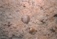
Image VB_GB1_36680013 |
Image VB_GB1_36680013. Tunicate colonies of Didemnum sp. encrusting pebble gravel habitat. Partly-encrusted sea scallop is 4 inches (10 cm) in diameter. Station 311022 (41 deg 58.179 min N lat, 67 deg 31.848 min W lon). Northern Georges Bank. Water depth 43 m (141 ft). November 1, 2003. Collectors: Page Valentine, Jeremy Collie, Robert Reid. Photo credit: Page Valentine and Dann Blackwood, U.S. Geological Survey. Location no. 4.
Click here to download image. |

Image VB_GB1_36680014 |
Image VB_GB1_36680014. Tunicate colonies of Didemnum sp. completely covering pebble gravel habitat and surrounding hydroid colonies and a small burrowing anemone. Gastropod is approximately 4 inches (10 cm) long. Station 311022 (41 deg 58.179 min N lat, 67 deg 31.848 min W lon). Northern Georges Bank. Water depth 43 m (141 ft). November 1, 2003. Collectors: Page Valentine, Jeremy Collie, Robert Reid. Photo credit: Page Valentine and Dann Blackwood, U.S. Geological Survey. Location no. 4.
Click here to download image. |

Image VB_GB1_36680015 |
Image VB_GB1_36680015. Tunicate colonies of Didemnum sp. advancing over pebble gravel habitat. Unaffected sea scallop is 3 inches (8 cm) in diameter. Station 311022 (41 deg 58.179 min N lat, 67 deg 31.848 min W lon). Northern Georges Bank. Water depth 43 m (141 ft). November 1, 2003. Collectors: Page Valentine, Jeremy Collie, Robert Reid. Photo credit: Page Valentine and Dann Blackwood, U.S. Geological Survey.Location no. 4.
Click here to download image. |

Image VB_GB1_36970016 |
Image VB_GB1_36970016. Tunicate colonies of Didemnum sp. encrusting a boulder on pebble gravel habitat. Tunicates surrounding and overgrowing attached anemones and grey sea pork (Aplidium sp.). Image height is 22 inches (56 cm). Station 311023 (42 deg 00.109 min N lat, 67 deg 32.449 min W lon). Northern Georges Bank. Water depth 41 m (135 ft). November 1, 2003. Collectors: Page Valentine, Jeremy Collie, Robert Reid. Photo credit: Page Valentine and Dann Blackwood, U.S. Geological Survey. Location no. 5.
Click here to download image. |

Image VB_GB1_36970024 |
Image VB_GB1_36970024. Small, expanding colony of Didemnum sp. . Hydroid colony surrounded by tunicates. Pebble gravel habitat with small burrowing anemones. Image height is 25 inches (63 cm). Station 311023 (42 deg 00.109 min N lat, 67 deg 32.449 min W lon). Northern Georges Bank. Water depth 41 m (135 ft). November 1, 2003. Collectors: Page Valentine, Jeremy Collie, Robert Reid. Photo credit: Page Valentine and Dann Blackwood, U.S. Geological Survey.Location no. 2.
Click here to download image. |
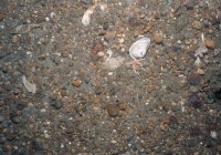
Image VB_GB1_36970026 |
Image VB_GB1_36970026. Very small colony of Didemnum sp. in upper right part of image to left of tan pebble. Pebble gravel habitat with small burrowing anemones. Image height is 20 inches (51 cm). Station 311023 (42 deg 00.109 min N lat, 67 deg 32.449 min W lon). Northern Georges Bank. Water depth 41 m (135 ft). November 1, 2003. Collectors: Page Valentine, Jeremy Collie, Robert Reid. Photo credit: Page Valentine and Dann Blackwood, U.S. Geological Survey.Location no. 5.
Click here to download image. |
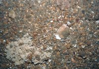
Image VB_GB1_36970034 |
Image VB_GB1_36970034. Small, expanding colony of Didemnum sp. on pebble gravel habitat. Hydroid colony surrounded by tunicates. Small burrowing anemones present. Sea scallop is approximately 4 inches (10 cm) in diameter. Two clam siphons above sea scallop in image. Station 311023 (42 deg 00.109 min N lat, 67 deg 32.449 min W lon). Northern Georges Bank. Water depth 41 m (135 ft). November 1, 2003. Collectors: Page Valentine, Jeremy Collie, Robert Reid. Photo credit: Page Valentine and Dann Blackwood, U.S. Geological Survey. Location no. 5.
Click here to download image. |

Image VB_GB1_36970035 |
Image VB_GB1_36970035. Very small tunicate colonies on hydroids in lower left center of image and in upper left center of image. Pebble gravel habitat with attached hydroids and small burrowing anemones. Image height is 19 inches (48 cm). Station 311023 (42 deg 00.109 min N lat, 67 deg 32.449 min W lon). Northern Georges Bank. Water depth 41 m (135 ft). November 1, 2003. Collectors: Page Valentine, Jeremy Collie, Robert Reid. Photo credit: Page Valentine and Dann Blackwood, U.S. Geological Survey. Location no. 5.
Click here to download image. |

Image DB_GB5_03015041 |
Image DB_GB5_03015041. Tunicate colony of Didemnum sp. encrusting the calcareous tubes of the colonial worm Filograna implexa. The tunicate colony is contracted. White bar is 2 centimeters (0.8 inches). Station 311024 (41 deg 57.439 min N lat, 67 deg 31.160 min W lon). Northern Georges Bank. Water depth 45 m (148 ft). November 1, 2003. Collectors: Jeremy Collie, Page Valentine, Robert Reid. Photo credit: Dann Blackwood, U.S. Geological Survey.Location no. 6.
Click here to download image.
|

Image DB_GB5_03015035 |
Image DB_GB5_03015035, tunicate colony of D. sp. encrusting a mussel shell.. Tunicate colony of Didemnum sp. encrusting a mussel shell. The long rope-like extensions possible encrust organisms such as hydroids that commonly attach to shells. The tunicate colony is contracted. White bar is 2 centimeters (0.8 inches). Station 311024 (41 deg 57.439 min N lat, 67 deg 31.160 min W lon). Northern Georges Bank. Water depth 45 m (148 ft). November 1, 2003. Collectors: Jeremy Collie, Page Valentine, Robert Reid. Photo credit: Dann Blackwood, U.S. Geological Survey. Location no. 6.
Click here to download image. |

Image DB_GB6_0301548a |
Image DB_GB6_0301548a. Tunicate colonies of Didemnum sp. encrusting a naturalist dredge sample of pebble gravel and shell material. Note the tunicate appendages on the mussel shell in the left center part of the photo. The tunicate colonies are contracted. Station 311032 (41 deg 57.19 min N lat, 67 deg 31.080 min W lon). Northern Georges Bank. Water depth 47 m (154 ft). November 1, 2003. Collectors: Jeremy Collie, Page Valentine, Robert Reid. Photo credit: Dann Blackwood, U.S. Geological Survey. Location no. 7.
Click here to download image. |

Image DB_GB6_0301548b |
Image DB_GB6_0301548b. Tunicate colonies of Didemnum sp. encrusting a naturalist dredge sample of pebble gravel. The encrusted sea scallop is approximately 5 inches (13 cm) in diameter. Station 311032 (41 deg 57.19 min N lat, 67 deg 31.080 min W lon). Northern Georges Bank. Water depth 47 m (154 ft). November 1, 2003. Collectors: Jeremy Collie, Page Valentine, Robert Reid. Photo credit: Dann Blackwood, U.S. Geological Survey. Location no. 7.
Click here to download image. |
|

 U.S. Department of the Interior |
U.S. Geological Survey
U.S. Department of the Interior |
U.S. Geological Survey