
General Information
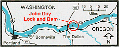 John Day Dam is located at the head of Lake Celilo, 216 miles upstream from the mouth of the Columbia River. The dam crosses the river near Rufus, Oregon, about 25 miles upstream from The Dalles, just below the mouth of the John Day River. To get to John Day Dam take exit 109 from Interstate 84.
 John Day Dam (66k JPEG)
The project consists of a navigation lock, spillway, powerhouse and fish passage facilities on both shores. Various recreational facilities are provided along the shores of Lake Umatilla and on the John Day River (Lake Umatilla, impounded by the dam, extends upstream about 76 miles to the foot of McNary Dam).
Construction began in 1958 and was completed in 1971, at a total cost of $511 million. At the time of it's completion, John Day Dam Powerhouse was the second largest in the world. Completion of the John Day Dam marked the final step in harnessing the lower waters of the Columbia River.
The workforce that maintains and operates John Day Lock and Dam includes engineers, powerhouse and lock operators, skilled crafts, warehouse workers, rangers, guides and office administrators.
Power Generating Capacity
 The first of the 16 main generators began operating in 1968; the last in 1971. At peak production, the powerhouse is capable of producing 2.2 million kilowatts, enough to meet the electrical needs of two cities the size of Seattle, Washington.
Watercraft Lockage
 Lake Umatilla provides slack water for navigation, with a minimum 15 foot depth in the main channel. The navigation lock, located on the Washington shore, is 86 feet wide, 675 feet long, and provides 15 feet of water depth over the sills. With a 113-foot maximum lift, it is the highest single-lift lock in the free world. Millions of tons of commodities move through the locks every year, including petroleum, nitrogen, farm and forest products, grain and wood products.
Project Data |
Measure |
Metric |
|---|---|---|
| Powerhouse Length | 1975 ft | 606 m |
| Powerhouse Generating Capacity | 2,160,000 kw | |
| Navigation Lock Chamber Length | 675 ft | 198.1 m |
| Navigation Lock Chamber Width | 86 ft | 26.7 m |
| Navigation Lock Maximum Lift | 113 ft | 34.4 m |
| Lake Umatilla Length | 76.4 mi | 123 km |