
USGS/Cascades Volcano Observatory, Vancouver, Washington
California Volcanoes and Volcanics
Maps and Graphics
-
 [Interactive Imagemap] ...
[Map,150K,GIF] ...
[Interactive Imagemap] ...
[Map,150K,GIF] ...
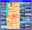
Cascade Range Volcanoes
-- Graphic by: Lyn Topinka, 1996
-
 [Map,20K,InlineGIF]
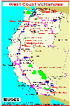
Major West Coast Volcanoes - Washington, Oregon, and California
-
 [Map,27K,InlineGIF]
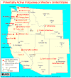
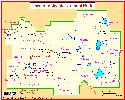
Potentially Active Volcanoes of the Western United States
-- Modified from: Brantley, 1994, Volcanoes of the United States:
USGS General Interest Publication
-
 [Graphic,70K,InlineGIF]
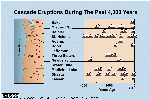
Cascades Eruptions During the Past 4000 Years
-
 [Map,65K,InlineGIF]
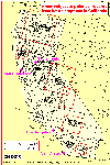
Areas subject to potential hazards from future eruptions in California.
-- Modified from: Miller, 1989, USGS Bulletin 1847
-
 [Map,12K,InlineGIF]
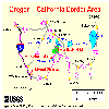
California-Oregon border area, with Mount Shasta, Medicine Lake, and
Lava Beds National Monument
-- Modified from: National Park Service, 1998
-
 [Map,16K,InlineGIF]
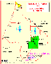
Lava Beds National Monument, Medicine Lake Caldera, and Vicinity
-- Modified from: Donnelly-Nolan, 1981, USGS Circular 838, and
Dzurisin et.al., 1991, JGR, v.96, no.B10
-
 [Map,22K,InlineGIF]
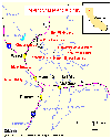
Location Map: Mount Shasta and Vicinity
-- Modified from: Miller, 1980, USGS Bulletin 1503
-
 [Map,14K,InlineGIF]
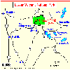
Location Map: Lassen Volcanic National Park and Vicinity
-- Modified from: National Park Service
-
 [Map,21K,InlineGIF]
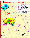
Lassen Volcanic National Park with Select Place Names
-- Modified from: National Park Service
-
 [Map,18K,InlineGIF]
Long Valley Vicinity
-- Modified from: USGS/Menlo Park
Return to:
[California Volcanoes and Volcanics Menu] ...
[MORE Cascade Range Maps and Graphics]
[Lassen Peak Maps and Graphics]
[Long Valley-Mammoth-Inyo-Mono Maps and Graphics]
[Medicine Lake-Lava Beds Maps and Graphics]
[Mount Shasta Maps and Graphics]

Use of CVO Material and Copyright Information
URL for CVO HomePage is:
<http://vulcan.wr.usgs.gov/home.html>
URL for this page is:
<http://vulcan.wr.usgs.gov/Volcanoes/California/Graphics/framework.html>
If you have questions or comments please contact:
<GS-CVO-WEB@usgs.gov>
09/02/08, Lyn Topinka