
USGS/Cascades Volcano Observatory, Vancouver, Washington
Medicine Lake, California
Lava Beds, California
Maps and Graphics
-
 [Interactive Imagemap] ...
[Map,150K,GIF] ...
[Interactive Imagemap] ...
[Map,150K,GIF] ...
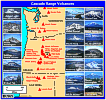
Cascade Range Volcanoes
-- Graphic by: Lyn Topinka, 1996
-
 [Map,20K,InlineGIF]
Major West Coast Volcanoes - Washington, Oregon, and California
-
 [Map,27K,InlineGIF]
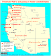
Potentially Active Volcanoes of the Western United States
-- Modified from: Brantley, 1994, Volcanoes of the United States:
USGS General Interest Publication
-
 [Graphic,70K,InlineGIF]
Cascades Eruptions During the Past 4000 Years
-

Seismic Monitoring at Cascade Volcanic Centers - The Big Picture
Informational text and shaded relief map
showing locations of all PNSN/NCSN seismic stations operating in the Pacific Northwest as of November, 2003. Map includes the 13 major Cascade volcanic centers.
-- Excerpt from: Moran, 2005, USGS Scientific Investigations Report 2004-5211
-
 [Map,65K,InlineGIF]
Areas subject to potential hazards from future eruptions in California.
-- Modified from: Miller, 1989, USGS Bulletin 1847
-
 [Map,12K,InlineGIF]
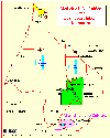
California-Oregon border area, with Mount Shasta, Medicine Lake, and
Lava Beds National Monument
-- Modified from: National Park Service, 1998
-
 [Map,16K,InlineGIF]
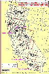
Lava Beds National Monument, Medicine Lake Caldera, and Vicinity
-- Modified from: Donnelly-Nolan, 1981, USGS Circular 838, and
Dzurisin et.al., 1991, JGR, v.96, no.B10
-
 [Map,40K,InlineGIF]
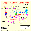
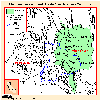
Medicine Lake Volcano and Mount Shasta Area
-- Location map showing the Medicine Lake volcano - Mount Shasta area of the
southern Cascade Range, northern California.
Pale green pattern indicates extent of lavas
of Medicine Lake volcano. Heavy lines are faults, with bar and ball on
downthrown side (Gay and Aune [1958] and air photograph interpretation).
Blue line represents the 1954-1989 leveling route.
Contour interval is 1000 feet (305 m).
-- Modified from: Dzurisin, et.al., 1991,
IN: Journal of Geophysical Research, v.96, no.B10.
Return to:
[Medicine Lake Menu] ...
[Medicine Lake Eruptive History Menu] ...
[MORE Cascade Range Maps and Graphics]
[MORE California Maps and Graphics]

Use of CVO Material and Copyright Information
URL for CVO HomePage is:
<http://vulcan.wr.usgs.gov/home.html>
URL for this page is:
<http://vulcan.wr.usgs.gov/Volcanoes/MedicineLake/Graphics/framework.html>
If you have questions or comments please contact:
<GS-CVO-WEB@usgs.gov>
09/02/08, Lyn Topinka